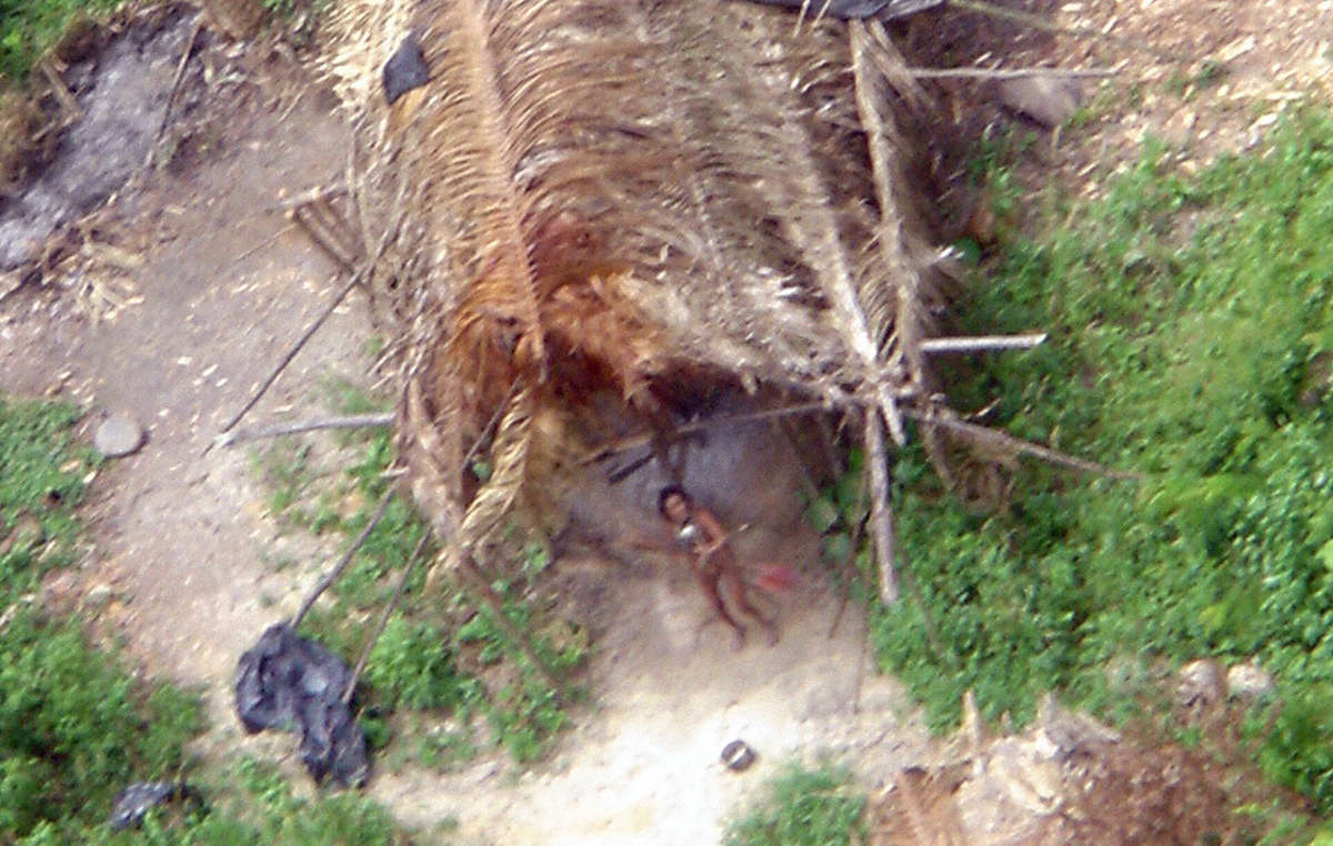
by DGR News Service | Nov 16, 2020 | Biodiversity & Habitat Destruction
by Blake Lavia and Tzintzun Aguilar-Izzo / Talking Wings Collective
Oct 9th, 2020, Movimiento por la Defensa de la Sierra, Coatepec, Veracruz, Mexico
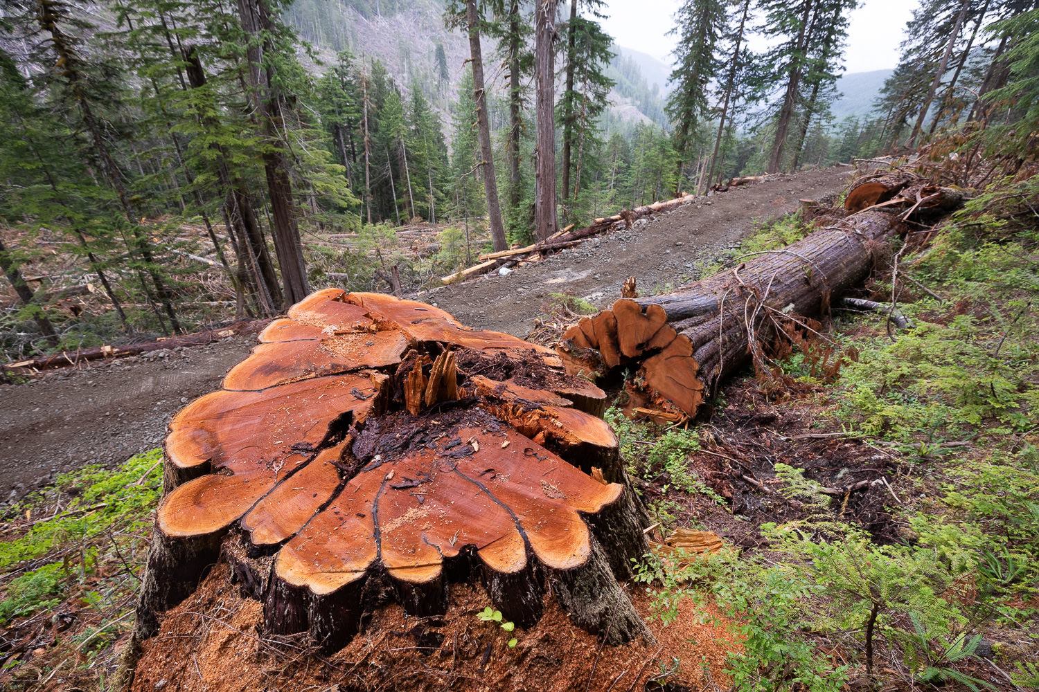
Five thousand acres of cloud forest are currently being threatened in Coatepec, Veracruz, Mexico. This land is, at present, being held by squatters, who, with the backing of local politicians, have claimed to be the forest’s rightful owners. They displaced dozens of families and are threatening one of Mexico’s most vital ecosystems. These 5,000 acres of land contain three municipal parks and one archeological site. While the land’s original stewards and forest protectors are engaged in a legal battle with the “invaders,” the deforestation of this fragile ecosystem has already commenced. This act of environmental devastation has wide political/economic ramifications. If you control Coatepec’s mountains, you control the subsistence and livelihood of millions.
The Coatepec Cloud Forest
The cloud forest above Coatepec is known as “la fabrica de agua” (the water factory). It is one of the last “water factories” of its kind in Mexico, and it moderates the weather of the entire region. The clouds that roll in from the Gulf of Mexico are captured by the forest canopy, the moisture forming a thick mist that shrouds the mountainside. Trees, moss, and orchids collaborate in an infinitely diverse ecosystem to retain the water that feed the region’s rivers, bringing life to the valleys bellow. The cities of Coatepec, Xalapa, and Cardel rely on this water, not to mention most of the communities of central Veracruz.
Globally, cloud forests are bastions of biodiversity. They harbor animal, and plant that are threatened by the shifting tides of the climate crises and uncontrolled land use. Coatepec’s cloud forest now hosts 90 plant, animal, and fungal species on the verge of extinction. Coupled with the biodiversity loss, the destruction of this ecosystem holds serious repercussions for the entire watershed. Without the cloud forest, the rivers will run dry, and the entire region will see considerably less rainfall. In short, the destruction of the cloud forest will spell drought and devastation for all.
The Invasion
In January 2019, a faction of the “Central Independiente de Obreros Agrícolas y Campesinos” (The Independent Organization of Agricultural Laborers and Farmers) set up an encampment on the 2,000 acres of cloud forest known as the Jinicuil Manso estate. CIOAC verbally threatened more than 500 original stewards of the land and claimed to be the legal owner of the property. While the information is difficult to corroborate, local activist networks say that the organizers of the CIOAC encampment came from outside the region, and do not hold legal rights to the said property. The community members who own land in the Jinicuil Manso estate submitted complaints to the local authorities. While the government “invited” the squatters to move off the premises, they requested that the community members refrain from engaging directly with CIOAC, to prevent physical aggression.
The situation was further complicated in February 2020, when the local authorities issued a “measurement and demarcation notice,” requesting that all the landowners submit paperwork confirming their title to the land. Many of the land’s stewards were not aware of the government’s decree. Others did not have the paperwork to prove that they owned their properties, even though the land had been in their family for generations. The local government never specified the reasons for this “demarcation notice,” and never compared the documents submitted by the land’s stewards with those provided by CIOAC. Instead, they refused to consider the documents submitted, and appear to favor CIOAC’s land claim, a land claim that local activists argue has been falsified.
The Electoral Politics of Water and Land
The local community groups, such as “Por la Defensa de la Sierra de Coatepec,” and the individual landowners, are currently involved in court cases with CIOAC. Throughout the process, it has it became clear the larger political forces are involved in the illegal “settlement” of the cloud forest. The CIOAC members have direct connection with major political parties in the area, with whom they have garnered ample political support. In addition, they have publicly thanked the governor of the State of Veracruz, Cuitlahuac García Jiménez, for his backing (though it is unclear whether this was just political posturing on the part of CIOAC).
Land, environmental destruction, and electoral politics has been devastatingly intertwined in Mexico for decades. When CIOAC first “invaded” the cloud forest, they invited citizens from the surrounding regions to squat on the appropriated land. Community members who did not own land of their own, and/or were seeking greater financial stability, settled in the cloud forest. Forest protectors have observed between 100 to 300 community members in the encampments at a time. They cut down trees, hunt the local fauna, and set up their septic systems to run off into the precious streams. When forest protectors attempt to plant trees or talk with the squatters, the squatters respond violently. They have been known to brandish guns and machetes, defending the land that has been promised to them.
Political figures from various parties in the region have sought to partner with the CIOAC settlers, nurturing a solid voting block of support. Leading up to the future regional and national elections, the ruling political parties have reacted favorably to the CIOAC’s land claims. However, underneath the surface, the forest protectors and activists claim that there is an even darker story. The people that live in the encampments of Jinicuil Manso could also be serving as a human shield, emptying the land for a larger economic interest that seeks to control the most vital resource of all: water.
The Conquest of the Cloud Forest
While at first glance the squatters could appear to be land hungry farmers, they are in fact just a cog in the virulent political system. Local activists believe that the squatters could be a facade for a political and economic interest that seeks to take over the forest of the region. Nestle, Coca-Cola, and other international corporations have huge factories in Coatepec, and have been seeking to control the region’s water supply for decades. Over the last series of elections, the community members have seen this same political/environmental ploy play out, though not to this level of devastation.
Veracruz is one the deadliest regions for land and water protectors in the world. “Por la Defensa de la Sierra de Coatepec” continues to organize throughout the region, raising awareness about the plight of the cloud forest, and the people that have been displaced. However, the settlers began threatening the lives of the forest protectors. When the organizers tried to negotiate with them in person, they were attacked with machetes. In the end, the CIAOC managed to scare most of the forest protectors into silence by actively threatening their families, while local authorities have turned a blind eye.
Action
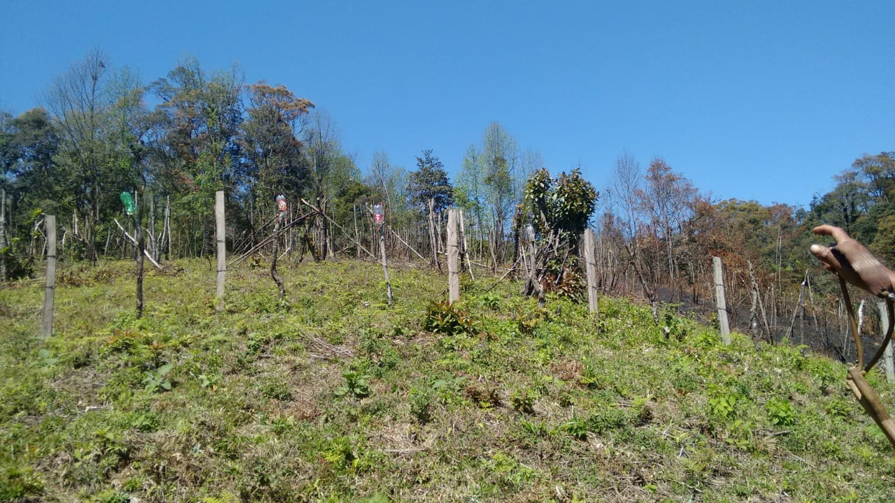
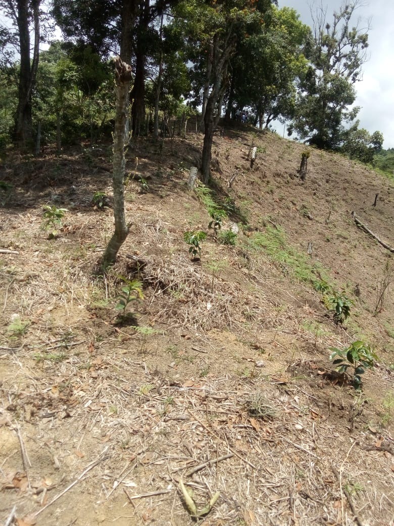
While many forest protectors are too afraid to speak in public or to the press, the fight is not over. On the 29th of November 2020, “Por la Defensa de la Sierra de Coatepec” will return to the stolen land to begin reforesting the trees that have been cut down. They will also initiate a barter market with the local community members who have been directly affected by the theft of land. While many forest protectors have been forced to move to surrounding cities to protect their families, they are willing to risk their lives to defend and bring life back to the cloud forest.
How You Can help!
– Follow the “Movimiento por la Defensa de la Sierra” on social media and share the story with everyone you know.
– Show your support by commenting on their page, and/or sharing a video of support.
![[Old Growth Blockade] Old-Growth Blockade Enters Fourth Month](https://dgrnewsservice.org/wp-content/uploads/sites/18/2020/11/fairycreek.jpg)
by DGR News Service | Nov 12, 2020 | Obstruction & Occupation
Fairy Creek Blockade: defending old growth forests on unceded Pacheedaht territory
by Reuben Garbanzo, on Lekwungen territory
Joshua Wright, is a seventeen year old film-maker from Olympia, Washington with an irrepressible passion for protecting the last remaining old-growth temperate rainforests; and has handy access to a state-of-the-art digital mapping program that allows him to track and monitor industrial logging activities in near-real time. In early August, this year, he gave heads up to Vancouver island grassroots forest activists to a road-building crew subcontracted to Surrey-based tenure-holder of TFL 46, Teal Jones, cresting the ridge into the old-growth Yellow Cedar headwaters of Ada’itsx/ Fairy Creek watershed, the last unlogged tributary of the San Juan River system, unceded Pacheedaht territory, near Port Renfrew.
Forest firefighter Will O’Connell surveyed the road-building operation with spell-binding drone footage that captured earth-moving machinery operating on dangerously steep terrain pushing into a watershed never before logged, with no current cutblocks approved, but nonetheless heightening the risk of logging plan approvals, once the investment of road infrastructure had been established. This bold expose of a logging road incursion into one of the last roadless places on southern Vancouver island rapidly spread on social media and in the midst of a pandemic, galvanized forest defenders into non-violent direct action.
On Sunday, August 9th, twenty ancient forest activists from all over the south island, including the nearby communities of Port Renfrew and Cowichan valley, gathered at Lizard Lake and decided to set up a road blockade above the clouds 1000 metres up a treacherous logging road on a steep ridge overlooking the Gordon river valley, on the western flank of Fairy creek, where road-building into the Fairy, was slated the next work day. Tents were set up under the giant bucket of a gargantuan excavator and a 10′ diameter cedar log round from an ancient tree felled in the Klanawa Valley, propped vertically on a plywood frame, was installed as a barricade centrepiece across the road. When the Stone Pacific road crew arrived in darkness at 5 am the next morning they were politely confronted by a dozen people putting on the morning coffee around a small fire on the road end, with the intention of protecting Fairy Creek from road incursion.
Two weeks later another blockade was set up to protect the watershed on its eastern flank and to stop clearcut logging in an area of contiguous ancient forest that is part of the 5100 acre Fairy Creek rainforest, much of which is already under Old-Growth Management and Wildlife Habitat Area designation.
Pop-up blockades disrupting business as usual in other remnant old-growth forest locales have also sent a message to government and industry that in a down-spiraling climate and biodiversity crisis, disruption to the status quo is to be expected until the government takes decisive action to protect what is left of these globally significant and irreplaceable forests. The objectives/demands of all these blockade actions is to protect the last 1-3% of low-elevation old-growth rainforests left standing on so-called Vancouver island.
The Ada’itsx/Fairy Creek blockades are now entering their fourth month with no logging or road-building behind the barricades and no injunctions or arrests. This blockade, now the longest land-based direct action campaign on this island in over two decades has evolved quickly into a decentralized grassroots direct action movement under the banner of oldgrowthblockade, aimed to stem the tide of the colossal destruction of the shocking equivalent of 32 soccer fields of old-growth forests per day on the island alone.
Winterized infrastructure has been built at the main Fairy Creek base Camp, 7 kilometres off the the Pacific Marine Rd. including wood-heated Elder and Indigenous Warriors’ tents, bear-proof kitchen arbour, tool shed and hot water shower and change room. Dozens of volunteers communicating via several online platforms have provided coordination and mobilized material support to the frontlines which have been steadily maintained by a gritty, dedicated crew of core forest defenders, young and not so young, mostly women, who provide daily logistical coordination, elder care, leadership, hosting and reconnaissance on the ground.
This settler-Indigenous blockade has been blessed with the support and wise leadership of Pacheedaht elder Bill Jones who has asked that the entire valley, part of his childhood stomping ground, be dedicated as an Indigenous Protected Area in honour of the victims of the smallpox epidemic. Pacheedaht Chief and council have not responded for or against the blockade. The area is in the electoral riding of Premier John Horgan who has himself yet to respond to the demands of the blockade to protect Fairy Creek rainforest and all remaining old-growth temperate rainforests on the island.
On September 29th, the blockade received a strong statement of support from the Union of British Columbia Chiefs (UBCIC) who issued a breakthrough resolution calling on the Province to implement all 14 recommendations of their Old-Growth Strategy Review report and for the immediate protection of key old-growth forest hotpsots including Fairy Creek. Most significantly, their resolution called for government to assume responsibility in invesment in supporting First Nations to break free from the economic dependency on the old-growth forest destruction of their land-base, a major policy piece in the transition away from the destructive legacy of old-growth logging, once and for all.
To join the blockades:
https://oldgrowthblockade.com
To donate:
https://www.gofundme.com/f/bc-old-growth-blockade
Fairy Creek Blockade Chronology of Events:
August 1st : Discovery of Stone Pacific ( subcontracting to Teal Jones) road construction cresting the Ridge into the unlogged Fairy Creek headwaters
August 9: Grassroots activists from across Vancouver island meet at Lizard Lake and decide to erect an emergency logging road blockade at the end of Reid mainline, on a high ridge on the western side of Fairy Creek headwater, to prevent cutting, bulldozing and blasting activity into Fairy Creek the very next day. Notice is sent to Pacheedhat Chief and Council and Elder Bill Jones of setter-activist intentions to block road-building operations on their unceded territory.
August 10: Ridge camp blockade turns away Stone Pacific road and falling crews. Call out to request people to attend camp to defend against logging road construction into the last unlogged watershed in the San Juan River system.
August 17th: 2nd blockade at River Camp is established at another road access point into Fairy Creek along Granite mainline in the Renfrew Creek watershed, on the east side of Fairy Creek.
August 24th: a temporary, pop-up blockade is set up on Braden Mainline aimed at halting road-building and logging of old-growth forests on Edinburgh mountain, across from Fairy Creek in the San Juan river basin.
August 31st: Ridge camp blockade is moved 7kms down the road to a new blockade location aimed at halting road-construction into Fairy Creek and logging of contiguous old-growth forest adjacent to the Fairy Creek watershed.
September 4: Pacheedaht elder Bill Jones releases an official letter of invitation to Indigenous and non-Indigenous forest defenders to unite on the territory to defend the old-growth rainforests on his ancestral lands. An Elder’s tent is built at River Camp, where the elder has been staying overnight.
September 6: A caravan of Indigenous youth and elders, from many territories visit the blockades to further advise on appropriate respect protocols for forest defenders taking action on the land. 📷
September 22: The blockade camp on Reid main is moved back to its original position at the top of the Ridge at the end of Reid main. More Pacheedaht community members visit the blockades.
October 3: Northview Timber pulls road-building machinery off the mountain, abandoning plans to push roads through into Fairy Creek, past Ridge Camp, until after winter. Ridge camp remains for monitoring. Winterization of River camp continues, including bear-proof communal kitchen shelter, wood-heated communal tents, tool shed and a hot water shower.
October 22: An exploratory trail is cut from the Ridge camp along the Ridge to a lookout point above Ada’itsx/Fairy Creek with a group of Indigenous youth.
October 25: A sacred fire is lit at River Camp by Indigenous elders, youth and matriarchs, for prayer and ceremony, supporting the blockade, the forest and forest protectors.
November 9: Pop-up blockade is established at Grierson main to protect rare valley bottom ancient rainforest from road-building into Camper Creek headwaters.
by DGR News Service | Oct 12, 2020 | Building Alternatives
This piece from Low-Tech Magazine examines the practice of coppicing trees for firewood and other uses. The author argues that this practice offers a sustainable, low-tech, small-scale alternative to industrial logging, and doesn’t threaten to accelerate global warming. While we don’t agree with every element of this piece, it is a very important article.
by Kris De Decker / Low-Tech Magazine
From the Neolithic to the beginning of the twentieth century, coppiced woodlands, pollarded trees, and hedgerows provided people with a sustainable supply of energy, materials, and food.

Pollarded trees in Germany. Image: René Schröder (CC BY-SA 4.0).
How is Cutting Down Trees Sustainable?
Advocating for the use of biomass as a renewable source of energy – replacing fossil fuels – has become controversial among environmentalists. The comments on the previous article, which discussed thermoelectric stoves, illustrate this:
- “As the recent film Planet of the Humans points out, biomass a.k.a. dead trees is not a renewable resource by any means, even though the EU classifies it as such.”
- “How is cutting down trees sustainable?”
- “Article fails to mention that a wood stove produces more CO2 than a coal power plant for every ton of wood/coal that is burned.”
- “This is pure insanity. Burning trees to reduce our carbon footprint is oxymoronic.”
- “The carbon footprint alone is just horrifying.”
- “The biggest problem with burning anything is once it’s burned, it’s gone forever.”
- “The only silly question I can add to to the silliness of this piece, is where is all the wood coming from?”
In contrast to what the comments suggest, the article does not advocate the expansion of biomass as an energy source. Instead, it argues that already burning biomass fires – used by roughly 40% of today’s global population – could also produce electricity as a by-product, if they are outfitted with thermoelectric modules. Nevertheless, several commenters maintained their criticism after they read the article more carefully. One of them wrote: “We should aim to eliminate the burning of biomass globally, not make it more attractive.”
Apparently, high-tech thinking has permeated the minds of (urban) environmentalists to such an extent that they view biomass as an inherently troublesome energy source – similar to fossil fuels. To be clear, critics are right to call out unsustainable practices in biomass production. However, these are the consequences of a relatively recent, “industrial” approach to forestry. When we look at historical forest management practices, it becomes clear that biomass is potentially one of the most sustainable energy sources on this planet.
Coppicing: Harvesting Wood Without Killing Trees
Nowadays, most wood is harvested by killing trees. Before the Industrial Revolution, a lot of wood was harvested from living trees, which were coppiced. The principle of coppicing is based on the natural ability of many broad-leaved species to regrow from damaged stems or roots – damage caused by fire, wind, snow, animals, pathogens, or (on slopes) falling rocks. Coppice management involves the cutting down of trees close to ground level, after which the base – called the “stool” – develops several new shoots, resulting in a multi-stemmed tree.

A coppice stool. Image: Geert Van der Linden.

A recently coppiced patch of oak forest. Image: Henk vD. (CC BY-SA 3.0)

Coppice stools in Surrey, England. Image: Martinvl (CC BY-SA 4.0)
When we think of a forest or a tree plantation, we imagine it as a landscape stacked with tall trees. However, until the beginning of the twentieth century, at least half of the forests in Europe were coppiced, giving them a more bush-like appearance. [1] The coppicing of trees can be dated back to the stone age, when people built pile dwellings and trackways crossing prehistoric fenlands using thousands of branches of equal size – a feat that can only be accomplished by coppicing. [2]


The approximate historical range of coppice forests in the Czech Republic (above, in red) and in Spain (below, in blue). Source: “Coppice forests in Europe”, see [1]
Ever since then, the technique formed the standard approach to wood production – not just in Europe but almost all over the world. Coppicing expanded greatly during the eighteenth and nineteenth centuries, when population growth and the rise of industrial activity (glass, iron, tile and lime manufacturing) put increasing pressure on wood reserves.
Short Rotation Cycles
Because the young shoots of a coppiced tree can exploit an already well-developed root system, a coppiced tree produces wood faster than a tall tree. Or, to be more precise: although its photosynthetic efficiency is the same, a tall tree provides more biomass below ground (in the roots) while a coppiced tree produces more biomass above ground (in the shoots) – which is clearly more practical for harvesting. [3] Partly because of this, coppicing was based on short rotation cycles, often of around two to four years, although both yearly rotations and rotations up to 12 years or longer also occurred.


Coppice stools with different rotation cycles. Images: Geert Van der Linden.
Because of the short rotation cycles, a coppice forest was a very quick, regular and reliable supplier of firewood. Often, it was cut up into a number of equal compartments that corresponded to the number of years in the planned rotation. For example, if the shoots were harvested every three years, the forest was divided into three parts, and one of these was coppiced each year. Short rotation cycles also meant that it took only a few years before the carbon released by the burning of the wood was compensated by the carbon that was absorbed by new growth, making a coppice forest truly carbon neutral. In very short rotation cycles, new growth could even be ready for harvest by the time the old growth wood had dried enough to be burned.
In some tree species, the stump sprouting ability decreases with age. After several rotations, these trees were either harvested in their entirety and replaced by new trees, or converted into a coppice with a longer rotation. Other tree species resprout well from stumps of all ages, and can provide shoots for centuries, especially on rich soils with a good water supply. Surviving coppice stools can be more than 1,000 years old.
Biodiversity
A coppice can be called a “coppice forest” or a “coppice plantation”, but in reality it was neither a forest nor a plantation – perhaps something in between. Although managed by humans, coppice forests were not environmentally destructive, on the contrary. Harvesting wood from living trees instead of killing them is beneficial for the life forms that depend on them. Coppice forests can have a richer biodiversity than unmanaged forests, because they always contain areas with different stages of light and growth. None of this is true in industrial wood plantations, which support little or no plant and animal life, and which have longer rotation cycles (of at least twenty years).

Coppice stools in the Netherlands. Image: K. Vliet (CC BY-SA 4.0)

Sweet chestnut coppice at Flexham Park, Sussex, England. Image: Charlesdrakew, public domain.
Our forebears also cut down tall, standing trees with large-diameter stems – just not for firewood. Large trees were only “killed” when large timber was required, for example for the construction of ships, buildings, bridges, and windmills. [4] Coppice forests could contain tall trees (a “coppice-with-standards”), which were left to grow for decades while the surrounding trees were regularly pruned. However, even these standing trees could be partly coppiced, for example by harvesting their side branches while they were alive (shredding).
Multipurpose Trees
The archetypical wood plantation promoted by the industrial world involves regularly spaced rows of trees in even-aged, monocultural stands, providing a single output – timber for construction, pulpwood for paper production, or fuelwood for power plants. In contrast, trees in pre-industrial coppice forests had multiple purposes. They provided firewood, but also construction materials and animal fodder.
The targeted wood dimensions, determined by the use of the shoots, set the rotation period of the coppice. Because not every type of wood was suited for every type of use, coppiced forests often consisted of a variety of tree species at different ages. Several age classes of stems could even be rotated on the same coppice stool (“selection coppice”), and the rotations could evolve over time according to the needs and priorities of the economic activities.

A small woodland with a diverse mix of coppiced, pollarded and standard trees. Image: Geert Van der Linden.
Coppiced wood was used to build almost anything that was needed in a community. [5] For example, young willow shoots, which are very flexible, were braided into baskets and crates, while sweet chestnut prunings, which do not expand or shrink after drying, were used to make all kinds of barrels. Ash and goat willow, which yield straight and sturdy wood, provided the material for making the handles of brooms, axes, shovels, rakes and other tools.
Young hazel shoots were split along the entire length, braided between the wooden beams of buildings, and then sealed with loam and cow manure – the so-called wattle-and-daub construction. Hazel shoots also kept thatched roofs together. Alder and willow, which have almost limitless life expectancy under water, were used as foundation piles and river bank reinforcements. The construction wood that was taken out of a coppice forest did not diminish its energy supply: because the artefacts were often used locally, at the end of their lives they could still be burned as firewood.

Harvesting leaf fodder in Leikanger kommune, Norway. Image: Leif Hauge. Source: [19]
Coppice forests also supplied food. On the one hand, they provided people with fruits, berries, truffles, nuts, mushrooms, herbs, honey, and game. On the other hand, they were an important source of winter fodder for farm animals. Before the Industrial Revolution, many sheep and goats were fed with so-called “leaf fodder” or “leaf hay” – leaves with or without twigs. [6]
Elm and ash were among the most nutritious species, but sheep also got birch, hazel, linden, bird cherry and even oak, while goats were also fed with alder. In mountainous regions, horses, cattle, pigs and silk worms could be given leaf hay too. Leaf fodder was grown in rotations of three to six years, when the branches provided the highest ratio of leaves to wood. When the leaves were eaten by the animals, the wood could still be burned.
Pollards & Hedgerows
Coppice stools are vulnerable to grazing animals, especially when the shoots are young. Therefore, coppice forests were usually protected against animals by building a ditch, fence or hedge around them. In contrast, pollarding allowed animals and trees to be mixed on the same land. Pollarded trees were pruned like coppices, but to a height of at least two metres to keep the young shoots out of reach of grazing animals.


Pollarded trees in Segovia, Spain. Image: Ecologistas en Acción.
Wooded meadows and wood pastures – mosaics of pasture and forest – combined the grazing of animals with the production of fodder, firewood and/or construction wood from pollarded trees. “Pannage” or “mast feeding” was the method of sending pigs into pollarded oak forests during autumn, where they could feed on fallen acorns. The system formed the mainstay of pork production in Europe for centuries. [7] The “meadow orchard” or “grazed orchard” combined fruit cultivation and grazing — pollarded fruit trees offered shade to the animals, while the animals could not reach the fruit but fertilised the trees.

Forest or pasture? Something in between. A “dehesa” (pig forest farm) in Spain. Image by Basotxerri (CC BY-SA 4.0).

Cattle grazes among pollarded trees in Huelva, Spain. (CC BY-SA 2.5)

A meadow orchard surrounded by a living hedge in Rijkhoven, Belgium. Image: Geert Van der Linden.
While agriculture and forestry are now strictly separated activities, in earlier times the farm was the forest and vice versa. It would make a lot of sense to bring them back together, because agriculture and livestock production – not wood production – are the main drivers of deforestation. If trees provide animal fodder, meat and dairy production should not lead to deforestation. If crops can be grown in fields with trees, agriculture should not lead to deforestation. Forest farms would also improve animal welfare, soil fertility and erosion control.
Line Plantings
Extensive plantations could consist of coppiced or pollarded trees, and were often managed as a commons. However, coppicing and pollarding were not techniques seen only in large-scale forest management. Small woodlands in between fields or next to a rural house and managed by an individual household would be coppiced or pollarded. A lot of wood was also grown as line plantings around farmyards, fields and meadows, near buildings, and along paths, roads and waterways. Here, lopped trees and shrubs could also appear in the form of hedgerows, thickly planted hedges. [8]

Hedge landscape in Normandy, France, around 1940. Image: W Wolny, public domain.

Line plantings in Flanders, Belgium. Detail from the Ferraris map, 1771-78.
Although line plantings are usually associated with the use of hedgerows in England, they were common in large parts of Europe. In 1804, English historian Abbé Mann expressed his surprise when he wrote about his trip to Flanders (today part of Belgium): “All fields are enclosed with hedges, and thick set with trees, insomuch that the whole face of the country, seen from a little height, seems one continued wood”. Typical for the region was the large number of pollarded trees. [8]
Like coppice forests, line plantings were diverse and provided people with firewood, construction materials and leaf fodder. However, unlike coppice forests, they had extra functions because of their specific location. [9] One of these was plot separation: keeping farm animals in, and keeping wild animals or cattle grazing on common lands out. Various techniques existed to make hedgerows impenetrable, even for small animals such as rabbits. Around meadows, hedgerows or rows of very closely planted pollarded trees (“pollarded tree hedges”) could stop large animals such as cows. If willow wicker was braided between them, such a line planting could also keep small animals out. [8]

Detail of a yew hedge. Image: Geert Van der Linden.

Hedgerow. Image: Geert Van der Linden.

Pollarded tree hedge in Nieuwekerken, Belgium. Image: Geert Van der Linden.

Coppice stools in a pasture. Image: Jan Bastiaens.
Trees and line plantings also offered protection against the weather. Line plantings protected fields, orchards and vegetable gardens against the wind, which could erode the soil and damage the crops. In warmer climates, trees could shield crops from the sun and fertilize the soil. Pollarded lime trees, which have very dense foliage, were often planted right next to wattle-and-daub buildings in order to protect them from wind, rain and sun. [10]
Dunghills were protected by one or more trees, preventing the valuable resource from evaporating due to sun or wind. In the yard of a watermill, the wooden water wheel was shielded by a tree to prevent the wood from shrinking or expanding in times of drought or inactivity. [8]

A pollarded tree protects a water wheel. Image: Geert Van der Linden.

Pollarded lime trees protect a farm building in Nederbrakel, Belgium. Image: Geert Van der Linden.
Location Matters
Along paths, roads and waterways, line plantings had many of the same location-specific functions as on farms. Cattle and pigs were hoarded over dedicated droveways lined with hedgerows, coppices and/or pollards. When the railroads appeared, line plantings prevented collisions with animals. They protected road travellers from the weather, and marked the route so that people and animals would not get off the road in a snowy landscape. They prevented soil erosion at riverbanks and hollow roads.
All functions of line plantings could be managed by dead wood fences, which can be moved more easily than hedgerows, take up less space, don’t compete for light and food with crops, and can be ready in a short time. [11] However, in times and places were wood was scarce a living hedge was often preferred (and sometimes obliged) because it was a continuous wood producer, while a dead wood fence was a continuous wood consumer. A dead wood fence may save space and time on the spot, but it implies that the wood for its construction and maintenance is grown and harvested elsewhere in the surroundings.

Image: Pollarded tree hedge in Belgium. Image: Geert Van der Linden.
Local use of wood resources was maximised. For example, the tree that was planted next to the waterwheel, was not just any tree. It was red dogwood or elm, the wood that was best suited for constructing the interior gearwork of the mill. When a new part was needed for repairs, the wood could be harvested right next to the mill. Likewise, line plantings along dirt roads were used for the maintenance of those roads. The shoots were tied together in bundles and used as a foundation or to fill up holes. Because the trees were coppiced or pollarded and not cut down, no function was ever at the expense of another.
Nowadays, when people advocate for the planting of trees, targets are set in terms of forested area or the number of trees, and little attention is given to their location – which could even be on the other side of the world. However, as these examples show, planting trees closeby and in the right location can significantly optimise their potential.
Shaped by Limits
Coppicing has largely disappeared in industrial societies, although pollarded trees can still be found along streets and in parks. Their prunings, which once sustained entire communities, are now considered waste products. If it worked so well, why was coppicing abandoned as a source of energy, materials and food? The answer is short: fossil fuels. Our forebears relied on coppice because they had no access to fossil fuels, and we don’t rely on coppice because we have.
Our forebears relied on coppice because they had no access to fossil fuels, and we don’t rely on coppice because we have
Most obviously, fossil fuels have replaced wood as a source of energy and materials. Coal, gas and oil took the place of firewood for cooking, space heating, water heating and industrial processes based on thermal energy. Metal, concrete and brick – materials that had been around for many centuries – only became widespread alternatives to wood after they could be made with fossil fuels, which also brought us plastics. Artificial fertilizers – products of fossil fuels – boosted the supply and the global trade of animal fodder, making leaf fodder obsolete. The mechanisation of agriculture – driven by fossil fuels – led to farming on much larger plots along with the elimination of trees and line plantings on farms.
Less obvious, but at least as important, is that fossil fuels have transformed forestry itself. Nowadays, the harvesting, processing and transporting of wood is heavily supported by the use of fossil fuels, while in earlier times they were entirely based on human and animal power – which themselves get their fuel from biomass. It was the limitations of these power sources that created and shaped coppice management all over the world.

Harvesting wood from pollarded trees in Belgium, 1947. Credit: Zeylemaker, Co., Nationaal Archief (CCO)

Transporting firewood in the Basque Country. Source: Notes on pollards: best practices’ guide for pollarding. Gipuzkoaka Foru Aldundía-Diputación Foral de Giuzkoa, 2014.
Wood was harvested and processed by hand, using simple tools such as knives, machetes, billhooks, axes and (later) saws. Because the labour requirements of harvesting trees by hand increase with stem diameter, it was cheaper and more convenient to harvest many small branches instead of cutting down a few large trees. Furthermore, there was no need to split coppiced wood after it was harvested. Shoots were cut to a length of around one metre, and tied together in “faggots”, which were an easy size to handle manually.
It was the limitations of human and animal power that created and shaped coppice management all over the world
To transport firewood, our forebears relied on animal drawn carts over often very bad roads. This meant that, unless it could be transported over water, firewood had to be harvested within a radius of at most 15-30 km from the place where it was used. [12] Beyond those distances, the animal power required for transporting the firewood was larger than its energy content, and it would have made more sense to grow firewood on the pasture that fed the draft animal. [13] There were some exceptions to this rule. Some industrial activities, like iron and potash production, could be moved to more distant forests – transporting iron or potash was more economical than transporting the firewood required for their production. However, in general, coppice forests (and of course also line plantings) were located in the immediate vicinity of the settlement where the wood was used.
In short, coppicing appeared in a context of limits. Because of its faster growth and versatile use of space, it maximised the local wood supply of a given area. Because of its use of small branches, it made manual harvesting and transporting as economical and convenient as possible.
Can Coppicing be Mechanised?
From the twentieth century onwards, harvesting was done by motor saw, and since the 1980s, wood is increasingly harvested by powerful vehicles that can fell entire trees and cut them on the spot in a matter of minutes. Fossil fuels have also brought better transportation infrastructures, which have unlocked wood reserves that were inaccessible in earlier times. Consequently, firewood can now be grown on one side of the planet and consumed at the other.
The use of fossil fuels adds carbon emissions to what used to be a completely carbon neutral activity, but much more important is that it has pushed wood production to a larger – unsustainable – scale. [14] Fossil fueled transportation has destroyed the connection between supply and demand that governed local forestry. If the wood supply is limited, a community has no other choice than to make sure that the wood harvest rate and the wood renewal rate are in balance. Otherwise, it risks running out of fuelwood, craft wood and animal fodder, and it would be abandoned.

Mechanically harvested willow coppice plantation. Shortly after coppicing (right), 3-years old growth (left). Image: Lignovis GmbH (CC BY-SA 4.0).
Likewise, fully mechanised harvesting has pushed forestry to a scale that is incompatible with sustainable forest management. Our forebears did not cut down large trees for firewood, because it was not economical. Today, the forest industry does exactly that because mechanisation makes it the most profitable thing to do. Compared to industrial forestry, where one worker can harvest up to 60 m3 of wood per hour, coppicing is extremely labour-intensive. Consequently, it cannot compete in an economic system that fosters the replacement of human labour with machines powered by fossil fuels.
Coppicing cannot compete in an economic system that fosters the replacement of human labour with machines powered by fossil fuels
Some scientists and engineers have tried to solve this by demonstrating coppice harvesting machines. [15] However, mechanisation is a slippery slope. The machines are only practical and economical on somewhat larger tracts of woodland (>1 ha) which contain coppiced trees of the same species and the same age, with only one purpose (often fuelwood for power generation). As we have seen, this excludes many older forms of coppice management, such as the use of multipurpose trees and line plantings. Add fossil fueled transportation to the mix, and the result is a type of industrial coppice management that brings few improvements.

Coppiced trees along a brook in ‘s Gravenvoeren, Belgium. Image: Geert Van der Linden.
Sustainable forest management is essentially local and manual. This doesn’t mean that we need to copy the past to make biomass energy sustainable again. For example, the radius of the wood supply could be increased by low energy transport options, such as cargo bikes and aerial ropeways, which are much more efficient than horse or ox drawn carts over bad roads, and which could be operated without fossil fuels. Hand tools have also improved in terms of efficiency and ergonomics. We could even use motor saws that run on biofuels – a much more realistic application than their use in car engines. [16]
The Past Lives On
This article has compared industrial biomass production with historical forms of forest management in Europe, but in fact there was no need to look to the past for inspiration. The 40% of the global population consisting of people in poor societies that still burn wood for cooking and water and/or space heating, are no clients of industrial forestry. Instead, they obtain firewood in much of the same ways that we did in earlier times, although the tree species and the environmental conditions can be very different. [17]
A 2017 study calculated that the wood consumption by people in “developing” societies – good for 55% of the global wood harvest and 9-15% of total global energy consumption – only causes 2-8% of anthropogenic climate impacts. [18] Why so little? Because around two-thirds of the wood that is harvested in developing societies is harvested sustainably, write the scientists. People collect mainly dead wood, they grow a lot of wood outside the forest, they coppice and pollard trees, and they prefer the use of multipurpose trees, which are too valuable to cut down. The motives are the same as those of our ancestors: people have no access to fossil fuels and are thus tied to a local wood supply, which needs to be harvested and transported manually.

African women carrying firewood. (CC BY-SA 4.0)
These numbers confirm that it is not biomass energy that’s unsustainable. If the whole of humanity would live as the 40% that still burns biomass regularly, climate change would not be an issue. What is really unsustainable is a high energy lifestyle. We can obviously not sustain a high-tech industrial society on coppice forests and line plantings alone. But the same is true for any other energy source, including uranium and fossil fuels.
Written by Kris De Decker. Proofread by Alice Essam.
* Subscribe to our newsletter.
* Support Low-tech Magazine via Paypal or Patreon.
* Buy the printed website.
References:
[1] Multiple references:
Unrau, Alicia, et al. Coppice forests in Europe. University of Freiburg, 2018.
Notes on pollards: best practices’ guide for pollarding. Gipuzkoako Foru Aldundia-Diputación Foral de Gipuzkoa, 2014.
A study of practical pollarding techniques in Northern Europe. Report of a three month study tour August to November 2003, Helen J. Read.
Aarden wallen in Europa, in “Tot hier en niet verder: historische wallen in het Nederlandse landschap”, Henk Baas, Bert Groenewoudt, Pim Jungerius and Hans Renes, Rijksdienst voor het Cultureel Erfgoed, 2012.
[6] While leaf fodder was used all over Europe, it was especially widespread in mountainous regions, such as Scandinavia, the Alps and the Pyrenees. For example, in Sweden in 1850, 1.3 million sheep and goats consumed a total of 190 million sheaves annually, for which at least 1 million hectares deciduous woodland was exploited, often in the form of pollards. The harvest of leaf fodder predates the use of hay as winter fodder. Branches could be cut with stone tools, while cutting grass requires bronze or iron tools. While most coppicing and pollarding was done in winter, harvesting leaf fodder logically happened in summer. Bundles of leaf fodder were often put in the pollarded trees to dry. References:Logan, William Bryant. Sprout lands: tending the endless gift of trees. WW Norton & Company, 2019.
A study of practical pollarding techniques in Northern Europe. Report of a three month study tour August to November 2003, Helen J. Read.
Slotte H., “Harvesting of leaf hay shaped the Swedish landscape“, Landscape Ecology 16.8 (2001): 691-702.
[8] This information is based on several Dutch language publications:Handleiding voor het inventariseren van houten beplantingen met erfgoedwaarde. Geert Van der Linden, Nele Vanmaele, Koen Smets en Annelies Schepens, Agentschap Onroerend Erfgoed, 2020.
Handleiding voor het beheer van hagen en houtkanten met erfgoedwaarde. Thomas Van Driessche, Agentschap Onroerend Erfgoed, 2019
Knotbomen, knoestige knapen: een praktische gids. Geert Van der Linden, Jos Schenk, Bert Geeraerts, Provincie Vlaams-Brabant, 2017.
Handleiding: Het beheer van historische dreven en wegbeplantingen. Thomas Van Driessche, Paul Van den Bremt and Koen Smets. Agentschap Onroerend Erfgoed, 2017.
Dirkmaat, Jaap. Nederland weer mooi: op weg naar een natuurlijk en idyllisch landschap. ANWB Media-Boeken & Gidsen, 2006.
For a good source in English, see: Müller, Georg. Europe’s Field Boundaries: Hedged banks, hedgerows, field walls (stone walls, dry stone walls), dead brushwood hedges, bent hedges, woven hedges, wattle fences and traditional wooden fences. Neuer Kunstverlag, 2013.
If line plantings were mainly used for wood production, they were planted at some distance from each other, allowing more light and thus a higher wood production. If they were mainly used as plot boundaries, they were planted more closely together. This diminished the wood harvest but allowed for a thicker growth.
[9] In fact, coppice forests could also have a location-specific function: they could be placed around a city or settlement to form an impenetrable obstacle for attackers, either by foot or by horse. They could not easily be destroyed by shooting, in contrast to a wall. Source: [5]
[10] Lime trees were even used for fire prevention. They were planted right next to the baking house in order to stop the spread of sparks to wood piles, haystacks and thatched roofs. Source: [5]
[11] The fact that living hedges and trees are harder to move than dead wood fences and posts also has practical advantages. In Europe until the French era, there was no land register and boundaries where physically indicated in the landscape. The surveyor’s work was sealed with the planting of a tree, which is much harder to move on the sly than a pole or a fence. Source: [5]
[12] And, if it could be brought in over water from longer distances, the wood had to be harvested within 15-30 km of the river or coast.
[16] However, chainsaws can have adverse effects on some tree species, such as reduced growth or greater ability to transfer disease.
[17] Multiple sources that refer to traditional forestry practices in Africa:
Leach, Gerald, and Robin Mearns. Beyond the woodfuel crisis: people, land and trees in Africa. Earthscan, 1988.
Leach, Melissa, and Robin Mearns. “The lie of the land: challenging received wisdom on the African environment.” (1998)
Cline-Cole, Reginald A. “Political economy, fuelwood relations, and vegetation conservation: Kasar Kano, Northerm Nigeria, 1850-1915.” Forest & Conservation History 38.2 (1994): 67-78.