Editor’s note: When a hurricane like Helene or Milton ravages coastal communities, already-strained first responders face a novel, and growing, threat: the lithium-ion batteries that power electric vehicles, store PV solar, e-bikes, and countless gadgets. When exposed to the salty water of a storm surge or extreme heat, they are at risk of bursting into flames — and taking an entire house with them.
“Anything that’s lithium-ion and exposed to salt water can have an issue,” said Bill Morelli, the fire chief in Seminole, Florida, and the bigger the battery, the greater the threat. That’s what makes EVs especially hazardous. “[The problem] has expanded as they continue to be more and more popular.”
Also petrochemical-based building materials and furnishings have replaced traditional wood, fabric and metal materials in homes worldwide. But plastics are more flammable and release persistent toxic chemicals when burned or exposed to high heat. Over the last 25 years, wildfires have multiplied and intensified due to global warming, and often now jump the wildland-urban interface, burning whole neighborhoods and leaving behind a dangerous toxic home legacy. After the Camp Fire razed Paradise, California, in 2018, water utilities found high levels of volatile organic compounds in drinking water. Similar issues have arisen in places like Boulder County, Colorado, where the Marshall Fire destroyed nearly 1,000 structures in 2021,
“The extreme heatwaves of 2023, which fueled huge wildfires, and severe droughts, also undermined the land’s capacity to soak up atmospheric carbon. This diminished carbon uptake drove atmospheric carbon dioxide levels to new highs, intensifying concerns about accelerating climate change. Widespread wildfires across Canada and droughts in the Amazon in 2023 released about the same amount of carbon to the atmosphere as North America’s total fossil fuel emissions, underscoring the severe impact of climate change on natural ecosystems.”
The following story talks about the Moss Landing fire but there was also a fire that erupted in southeast Missouri at one of world’s largest lithium-ion battery recycling facilities and also in Madison County, Illinois.
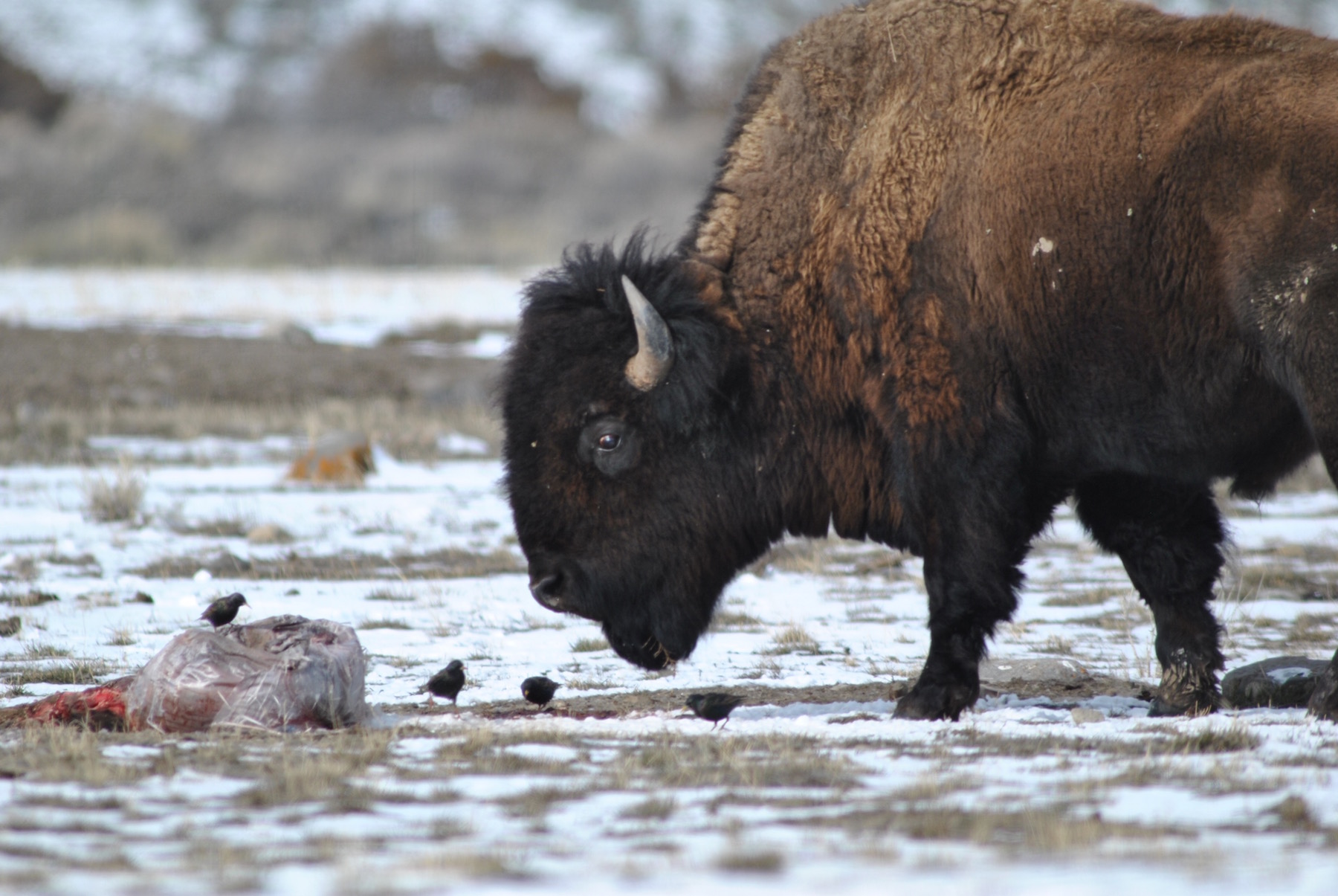
Batteries’ toxic gases can cause respiratory, skin and eye problems. Toxic gases from burning lithium-ion batteries can contaminate wildlife such as Monterey Bay’s unique tidal wetland.
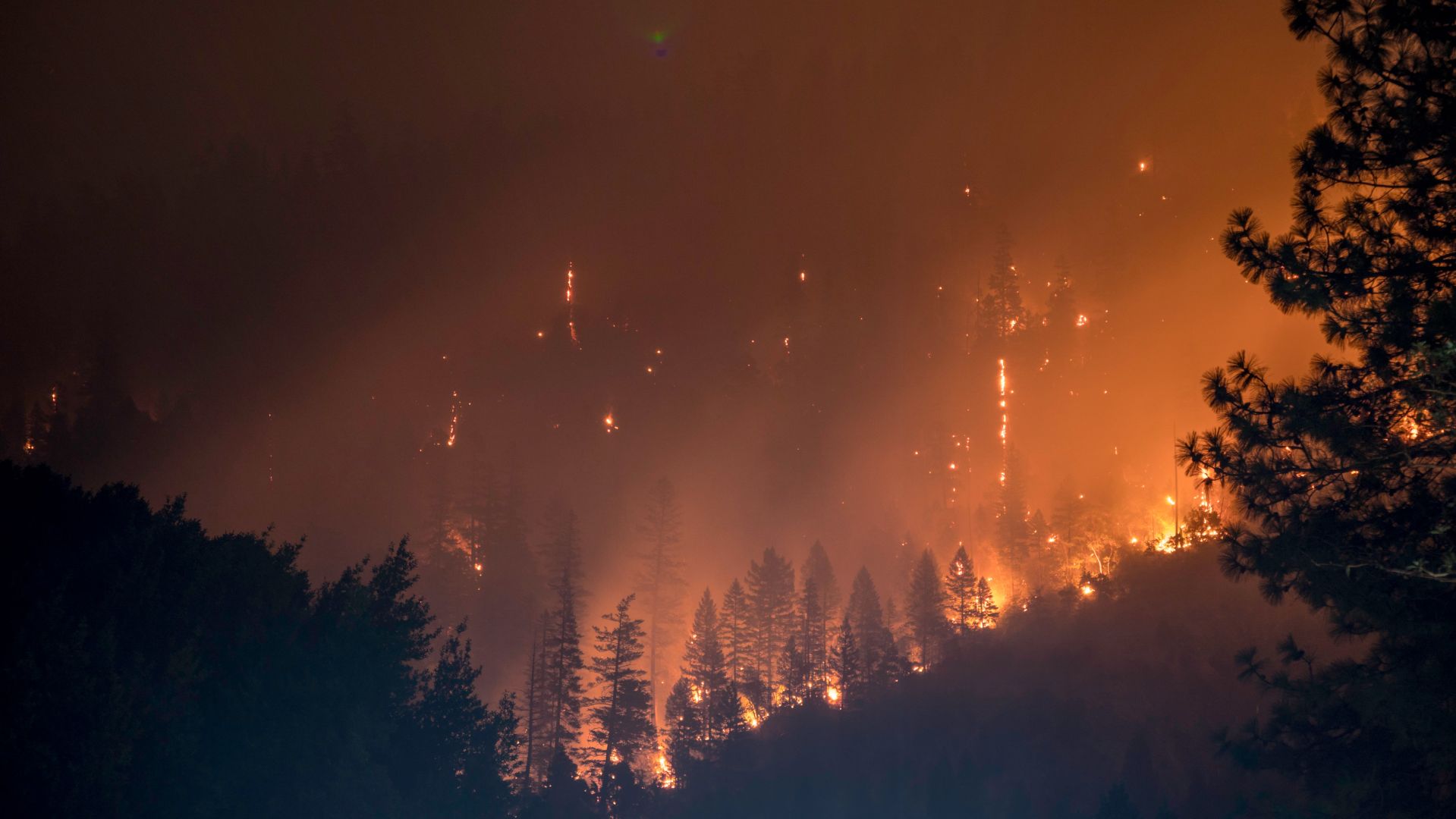
This is the fourth fire at the Moss Landing battery storage facility.
Referring to last week’s explosive fire, County Supervisor Glenn Church said, “This is a wake-up call for the industry. If we’re going to move ahead with sustainable energy, we need a safe battery system in place. State of the art safety protocols did not work.”
County officials lifted evacuation orders Friday evening after the U.S. Environmental Protection Agency found “no threat to human health.” Still, Highway 1 remains closed, and health officials in Monterey, San Venito and Santa Cruz counties advise residents to stay indoors, turn off ventilation systems and limit outdoor exposure. Www.ksbw.com provides live updates.
WILDFIRES AND URBAN FIRES
When the Los Angeles fires started January 7, I learned about the differences between wild and urban fires. Wildfires occur in forests or grasslands, fueled by trees or other vegetation. More than 80% of wildfires start by human activities like abandoned cigarettes, campfires and barbeques. Wildfire smoke can penetrate deep into peoples’ lungs and aggravate heart and lung diseases.
Urban fires—conflagrations—are fueled by combustible construction materials including wood framing, plastics, metals, furniture fabric and solar panels (hazardous waste). Because of houses’ flammable contents, urban fires burn extremely hot and generate toxic emissions. High winds and insufficient water supply intensify urban fires. Burning houses emit chemical toxins and generate more heat than burning trees (which, if alive, hold fire-resistant moisture).
INCLUDING LITHIUM-ION BATTERIES IN FIRE RISK ASSESSMENTS
Here’s a question: How do lithium-ion batteries contribute to urban fires?
Like much of the world, Southern California is now dotted with lithium batteries at every telecom cell site (for backup in the event of a power outage); in every electric vehicle, e-bike and hoverboard; in every EV charger; in laptops, tablets and smartphones—and their chargers; in smart utility meters on grid-connected houses and buildings; in off-grid rooftop solar PV systems’ batteries; in battery energy storage systems (BESS) for large-scale solar facilities and wind facilities.
RECOGNIZING THE FIRE RISKS CAUSED BY DRY AND COVERED SOIL
LA has endured eight months without rain. Drought increases fire risk.
Do fire risks also increase when soil can’t absorb and hold water? Soil’s ability to absorb and hold water is one of the Earth’s main cooling mechanisms. How do we reconcile this when we’ve covered land with paved roads, houses, malls, parking lots, data centers and battery storage facilities?
When rebuilding, what policies will ensure that fire’s toxic emissions (to air, soil and groundwater) will not affect future residents and farmers? Given that Governor Newsom has suspended environmental reviews to speed rebuilding in wildfire zones, what will protect residents in rebuilt areas from toxic exposures?
What measures would prevent lithium-ion batteries (at cell sites, in electric vehicles, smart meters, laptops, tablets, smartphones, rooftop solar system batteries, etc.) from catching fire and exploding? Could we prohibit lithium-ion batteries until they’re proven safe and ecologically sound from cradle-to-grave? New Hampshire legislators have introduced an ACT that would allow towns to decline 5G cell sites.
How could rebuilding Los Angeles respect the Earth? To reduce fire risk, support healthy water cycling and increase locally-produced food, could rebuilding policies encourage healthy soil structure?
To provide much-needed affordable housing in LA and elsewhere, would any mansion-owners turn their homes into multiple-family units?
RECONSIDER “SUSTAINABILITY”
Many communities and corporations aim to sustain themselves by installing battery energy storage systems and solar facilities. According to the California Energy Commission, since 2020, battery storage in the state has increased sevenfold—from 1,474 megawatts in 2020 to 10,383 megawatts by mid-2024. One megawatt can power 750 homes.
In New Mexico, AES Corporation has proposed building a 96 MW, 700-acre solar facility with 45 MWs/39 battery containers in Santa Fe County. (Each battery is about 39’ x 10’ x 8’.) Santa Fe’s Green Chamber of Commerce, the Sierra Club’s Rio Grande Chapter, the Global Warming Express and 350 Santa Fe support AES’s project.
Opponents of AES’s facility include the San Marcos Association, the Clean Energy Coalition and Ashley Schannauer (formerly a hearing officer for the state’s Public Regulatory Commission).
I frequently hear people call battery storage, solar PVs, industrial wind and EVs “sustainable.” Looked at from their cradles to their graves, this is simply not true. Mining lithium ravages ecosystems. So does burning coal and trees to make solar panels’ silicon. Refining lithium and making silicon electrically-conductive takes millions of gallons of water, daily. At end-of-life, these technologies are hazardous waste.
Meanwhile, I have many friends with rooftop solar systems and EVs. I would welcome forums about reducing our overall use of energy, water, extractions and international supply chains. I would welcome learning how to live with less.
As survivors of the LA fires, battery fires, Hurricane Helene, Israel’s decimation of Gaza and other catastrophes rebuild, what would communities look like if we considered our technologies’ impacts to ecosystems and public health from their cradles to graves? What would our communities look like if we think, “Ecosystems and public health first?”
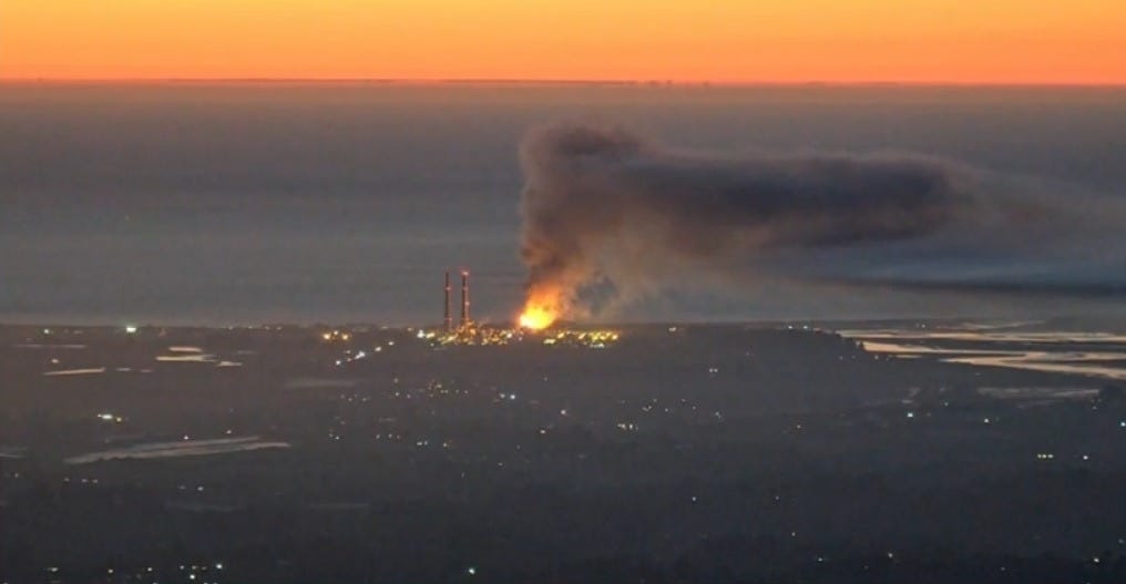
Banner Moss Landing battery plant fire, January 16-17, 2025.
MY MISTAKE While writing article I got help from a physicist of fire ignition, an electrical engineer, a forensic fire investigator and an electrician. I also went to the Internet, which informed me that in the event of an outage, cell sites’ power is backed up by lithium-ion batteries. This isn’t totally correct. While 5G small cells primarily use lithium ion batteries, larger cell towers usually backup with lead-acid batteries. I apologize for this error.
Editor’s note: The Ambler road is being planned in Alaska to connect the Dalton Highway with the Ambler Mining District. It will cross the Arctic National Park, state lands and native lands. The road in itself poses many threats to the wildlife which is described in the following piece. Many stakeholders are involved in this project, some of them support it and some of them oppose it. Proponents include the Congressional delegates from Alaska and native tribes who hope to benefit from the added jobs in their economy. Those who oppose it are the native groups whose subsistence hunting and gathering is threatened by the road and conservationists.
As George Wuerthner mentions in this piece, for a long time, the mining project was not feasible economically, and thus the area was protected from extraction. As we are extracting the last remaining fossil fuels, mining sites like these, which were too expensive in the past, become more necessary for the so called energy transition. We can expect this trend to grow in the future. As fossil fuels peak, there will be more and more extraction of these last remaining pockets of minerals. This mining prospect in Alaska is just another example of this.
While much conservation and political attention have focused on whether to allow oil development in the Arctic National Wildlife Refuge, another project, the Ambler Mining Project, and road construction proposal may pose even greater threats to the Arctic’s wildlife and wildlands. Despite this threat, The Ambler project has thus far received far less attention from the media, politicians and conservation organizations.
The proposed 211-mile Ambler Road would connect the Dalton Highway (pipeline haul road) with the Ambler Mining District in the western Brooks Range. The ore belt that stretches for 200 miles contains copper, cobalt, lead, and zinc and could be one of the most valuable deposits in the world, especially as people turn to electric vehicles.
There is new interest in encouraging the US development of critical minerals and energy, and the Ambler Mining proposal benefits from this push for US sources of minerals.
Although these deposits have been well-known for decades, the cost of mining, smelting, and transportation has precluded development. (I knew about the ore deposits in the 1970s when I lived and worked along the Kobuk River).
Years ago, I taught a class on Alaskan Environmental Politics. I emphasized that Alaska has more oil, coal, minerals, and even forests than most other parts of the United States. Many of these resources remain undeveloped because of the harsh climate, remote locations, and lack of access.
There are, for instance, substantial forest resources in Southeast Alaska. Still, they cannot be cut and transported without government subsidies because it’s cheaper to log trees in Oregon or Washington.
The Prudhoe Bay oil fields were the world’s 10th most significant oil reserves, and the other nine were in the Middle East. The Prudhoe Bay oil fields would have remained undeveloped had it not been for the construction of the Alaskan Oil Pipeline, which made these oil reserves economic to develop.
The Ambler Mineral deposits are considered “world-class.” Getting a road to the Ambler Deposits is the first step in making mining operations profitable. The Bureau of Land Managment (BLM) and the Corps of Engineers under the Trump Administration approved the road plan in 2020, and officials agreed to issue a 50-year right-of-way for the Alaska Industrial Development and Export Authority, the state public corporation working to develop the project.
However, the Biden Administration halted the road project while a Supplemental EIS process mandated by the courts was completed. However, my sources in Alaska suggest this may be for show. The comment period ended on November 4th, and the BLM review will likely be published sometime in the new year.
If you want to understand politics, all you have to do is follow the money.
The mining claims are owned mainly by local Iñupiat people living in NW Alaska coast and inland along the Kobuk River, represented by NANA corporation. They also operate the Red Dog Zinc mine, one of Alaska’s most significant mining and polluted sites.
During the land selection process created by the Alaska Native Claims Settlement Act (ANCSA), native people targeted the lands with valuable known mineralization or fossil fuel resources.
In the case of the Ambler mines, NANA shareholders are likely to be employed during road construction and mining operations.
One study estimates that 20% of all construction jobs will be held by local villagers, providing significant money input into these rural villages. NANA corporate leaders likely believe they are working in the best interests of their constituency.
In addition to NANA and some residents who would benefit from jobs and royalty payments, the road is also supported by the state of Alaska. The Alaska Industrial Development and Export Authority (AIDEA) would own Ambler Road.
Alaska’s Congressional Delegation, including newly elected half-Native Democrat Mary Peltrola and Republican Senator Lisa Murkowski, support the road and mining proposal. Peltrola has also joined her Republican counterparts in the Senate to support oil development in the Naval Petroleum Reserve.
The road, if built, would likely lead to road sprawl and the expansion of development in the region, including perhaps oil development in the Naval Petroleum Reserve to the north of the Brooks Range.
Although the supporters point out that the road would be a private road only accessible to industrial use, opponents point out that the same claim was made about the Pipeline Haul Road. However, in 1994 the state opened the Pipeline Road (Dalton Highway) for unrestricted, public use.
Opposition to the road comes from Tanana Chiefs and other Athabascan Indians living along the Koyukuk River and tributaries. The Athabascan would gain no advantage to a road except perhaps for more accessible and cheaper shipment of supplies. But they fear the road would disrupt subsistence hunting and gathering.
The Athabascans are not necessarily opposed to mining or oil development themselves. Doyon Native Corporation, which represents the Athabascan people of the Yukon Basin, during the land selection process of the Alaskan Native Claims Settlement Act has specifically targeted mineralized lands. Today, they have several active mining operations. However, Doyon has neither endorsed or opposed the Ambler Road and mining projects.
However, Doyon has proposed alternative road access to the Ambler district from Nome.
So, in essence, the road is pitting one ethnic native group against another.
In addition to opposition from some native people, many conservationists also oppose the road. The Ambler Road, if built, would cross the Gates of the Arctic National Park and Preserve and numerous other protected areas like the Kobuk Wild and Scenic Rivers.
The National Park Service did an excellent review of the potential impacts of the road on wetlands, water quality, fish, wildlife, subsistence, and recreational impacts on the park that applies to the total road mileage.
Conservationists and native people opposed to the mine have produced a good video about how the road would impact the Arctic:
An environmental review by the BLM in 2020 found that the road would impact salmon, caribou, and other wildlife.
Roads can be semi-permeable barriers, and although crossing such obstacles is possible, caribou may shift or entirely abandon their seasonal habitat. The disturbance and activity along the road and mining operations are likely to affect caribou in other ways. Studies have shown that caribou may travel up to 9.3 miles to avoid roads and 11.2 miles to avoid settlements.
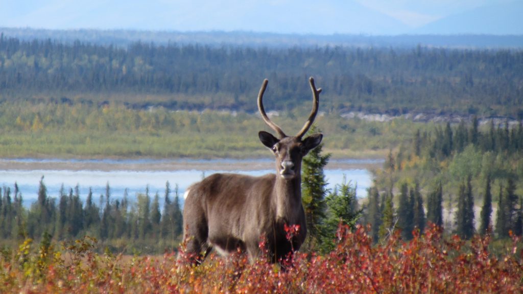
Thousands of caribou like this one traditionally cross the Kobuk River near Onion Portage in the fall. Accessibility statement: Single caribou looks directly at the camera surrounded by red shrubs, with river and forest in background.
For instance, a study of the Native-owned Red Dog Mine Industrial Access road north of Kotzebue found that just four vehicles an hour affected the migration of 30% of collared caribou, or approximately 72,000 individuals of the 2017 population estimates.
Linear features like roads also are used by predators like wolves. This can increase predator influence on prey like caribou. Roads and seismic lines in Alberta have led to increased predation on woodland caribou.
It also does not take much imagination to see that this road will eventually be extended to the coast by Kotzebue, fragmenting the entire western Brooks Range’s ecosystems.
Nevertheless, the road’s construction was approved by the Trump administration. However, the Biden Administration has ordered the Bureau of Land Management to reevaluate the Environmental Review.
The BLM accepted comments until November 4th. Whether the BLM review changes the decision to move forward with the road remains to be seen.
But my sources in Alaska say that the Biden Administration is likely to approve the road to help Alaskan politicians, perhaps with stricter regulations designed to address environmental concerns. The Biden Administration doesn’t want to oppose new Democratic Congressional Representative Mary Petrola who is a supporter of the mine road. Murkowsi was critical to Democrats in voting to convict Donald Trump for his role in the Jan. 6th insurrection, was one of three GOP to vote for nomination of Judge Ketanji Brown Jackson and she was the only GOP member to support the Voting Rights Bill. Biden does not want to alienate her potential support for other Democratic agenda votes.
I can’t emphasize enough that this road is one of the biggest threats to the Arctic’s wildlands and wildlife. It is bigger than just the development impacts that may result from the Ambler Mining operations. I have no doubts that the road, if built, will eventually make other mineral and oil, and gas sources economically viable to develop.
George Wuerthner is a professional photographer, writer, and ecologist. He has written more than three dozen books on natural history and other environmental topics. He is currently the Ed of Public Lands Media. Wuerthner has visited hundreds of mountain ranges around the West, more than 400 wilderness areas, more than 200 national park units, and every national forest west of the Mississippi. Listen to Derrick Jensen’s latest interview with George Wuerthner.
In a recent May 29 Bend Bulletin article, Senator Merkley asserted he “wants to boost spending on forest management by $1 billion annually through work, such as thinning and prescribed burning, to reduce the prospects of catastrophic wildfires.”
An unexamined assumption is that thinning/logging work significantly reduces the pejoratively named “catastrophic” fires.
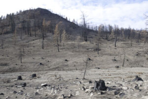
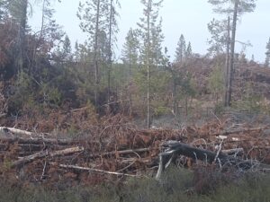
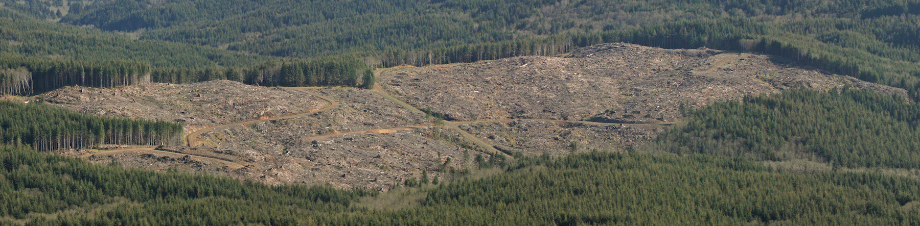
The Holiday Farm Fire burned the western slopes of the Cascades driven by extreme fire weather conditions, including high winds, charred acres of clearcuts, and other “fuel reductions.” Photo George Wuerthner.
Despite assertions from the Forest Service and others who will gain financially from inflated budgets to log our forests, one needs to ask if “fuel reductions” work to halt wildfires when burning under extreme fire weather conditions. That qualifier is important. All large blazes, like those that charred the western Cascades last Labor Day, burn swiftly through logged sites and other “fuel reductions.”
All such blazes occur under drought conditions, high temps, low humidity, and high winds. Thinning/logging and prescribed fires will not significantly preclude large blazes burning under extreme fire weather conditions.
This fire in the Scratchgravel Hills by Helena, Montana, driven by 50 mph, burned through this forest that had been thinned just six months prior to the blaze. Photo George Wuerthner.
I have traveled extensively around the West to view the aftermath of the largest fires, and every single one occurred during extreme fire weather conditions. Nothing, including thinning, logging, and prescribed burns, works to contain such fires when you have these conditions. I know of no exceptions.
Such blazes are only contained when the weather conditions change. Logging does not change the weather.
When it “appears” that fuel reductions worked under extreme conditions, you need to examine the actual burn circumstances during the blaze—the intensity of fire changes hour by hour.
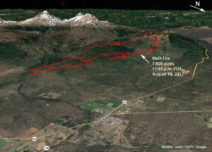
Proponents of forest thinning, including Merkley, suggest previous thinning projects saved Sisters, Oregon from the 2017 Milli Fire that burned within 2-3 miles of town. Yet if you read the Fire Incident Report carefully, such conclusions are questionable.
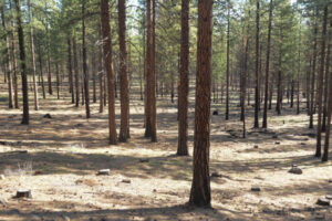
Thinned ponderosa pine stand near Sisters, Oregon, has resulted in a mono-culture of nearly even-aged forest that degrades the forest ecosystem and doesn’t stop fires burning under extreme fire weather. Thinning kills trees to preclude natural processes from killing trees. Photo George Wuerthner.
The Milli Fire burned through two previous burns (Pole Creek and Black Crater), presumably “fuel reductions.” It also burned through some thinned stands before thinning “saved” Sisters.
The red outline shows the wind-driven effect of the Milli Fire. A change in wind direction “saved” Sisters—photo USFS.
What happened is that the wind that had been moving the fire towards Sisters shifted, pushing the fire west and north into lava fields in the Three Sisters Wilderness.
Did thinning save Sisters? Maybe? However, a more nuanced analysis might conclude that a change in weather patterns is what “saved” Sisters.
Worse for our communities is that the Forest Service is “selling” a myth. Thinning/logging has been shown to increase fire spread. Thinning opens the forest to more wind penetration and more soil drying—both factors are conducive to fire spread during extreme fire weather.
Logging/thinning on the Deschutes NF leaves many fine fuels on the ground, often exacerbating fire spread. Photo George Wuerthner.
What burns in wildfires are the fine fuels: grass, shrubs, pine needles, small trees, and so forth. Large trees that thinning removes typically do not burn. That is why we have “snags” after a severe fire.
While thinning and prescribed burning treatments might lower fire intensity briefly immediately after the treatment, the chances that a fire will encounter a treatment is extremely rare.
Ironically, fuel reduction often increases the percentage of fine fuels on a site, ensuring that a blaze can readily spread if driven by high winds.
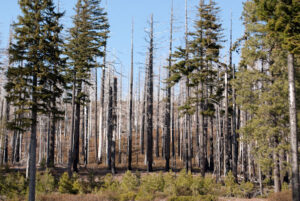
Ignored in the race to log our forests is that high severity fires are essential to healthy forest ecosystems. The biodiversity they produce often exceeds what is found in “green forests.”
Snags are critical to a healthy forest ecosystem. This is a sign of forest “health.” Photo George Wuerthner.
So the “story” the FS sells that thinning is “improving” forest health is another inaccurate statement. Dead trees resulting from fires, bark beetles, and other natural factors are critical to healthy forest ecosystems.
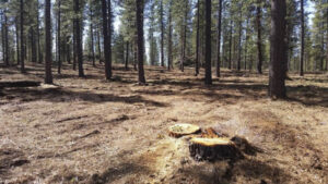
A sanitized forest stand (restoration) on the Deschutes NF, Oregon. Note the lack of small trees, lack of species diversity, lack of snags, down wood, and even shrubs. Photo George Wuerthner.
Thinning/logging is not benign. There are many impacts to the forest ecosystem from “restoration,” “fuel reductions,” and other euphemisms used to justify commercial logging. These include the spread of weeds, sedimentation in streams from logging roads, displacement of sensitive wildlife, loss of biomass, and loss of carbon storage.
Ultimately, we must deal with the GHG emissions that drive climate change, increasing drought, variable weather, and the conditions that favor large blazes.
In the meantime, increasing thinning and prescribed burning, except in the immediate area around communities, does little to protect homes. A much better way to spend scarce funds is to assist communities and homeowners in reducing the flammability of homes, burying power lines, and precluding new home construction in fire-prone areas.
“We do not want those whose first impulse is to compromise. We want no straddlers, for, in the past, they have surrendered too much good wilderness and primeval areas which should never have been lost.“
Mr. Wuerthner provides a long list of key conservation victories, including the Arctic National Wildlife Refuge (ANWR), Yellowstone, Grand Teton, and Olympic National Park – all of which were protected because heroic people refused to compromise. He cites notable failures, as well, writing:
“Pragmatists, in the end, leave messes for future generations to clean up. Capitulating to local interests with half-baked compromises in the interest of expediency typically produces uneven results. Either they do not adequately protect the land or create enormous headaches for future conservationists to undue often at a significant political and economic expense.“
The National Forests system was originally set up by President Theodore Roosevelt to protect forests from commercial activity – not log them. Compromises made by Gifford Pinchot, the first Chief of the Forest Service, resulted in mining companies (and later timber companies) gaining access to our National Forests. In the early 1900’s, almost no one could imagine that the seemingly limitless supply of virgin timber on private lands would one day be exhausted. They could not conceive that in a few generations’ time, timber companies and their partners in government agencies would be fighting tooth and nail to log the dwindling amount of old growth in our national forests – our collective natural heritage.
Lessons for the Elliott Mr. Wuerthner’s impassioned writing has left me wondering what lessons future generations will glean from the current process surrounding the Elliott State Forest (likely to be handed over to OSU with their timber-centric “research design” in the coming weeks). How will they see the unusually short public outreach/comment period and the rush to complete the OSU plan in time for the Land Board’s approval? How will they judge our mainstream environmental groups who seem afraid to openly criticize the egregious shortcomings of the plan and process? Will future Oregonians accept that compromise was the best we could hope for with the Elliott State Forest?
Insight from the Advisory Committee: In a recent email, Bob Sallinger (Portland Audubon member serving on the Advisory Committee) clarified the current situation with OSU’s draft plan for the Elliott:
“The draft plan calls for cutting up to 3287 acres of mature forest (between 65 and 152 years of age) over a period of a couple or two decades using selective harvest (20%-80% retention). Several hundred acres within this 3287 acres are on the younger side (65-100 years old) but the majority is in 100-152 year range…
I don’t think there is anybody in the conservation community that thinks it is a good idea to cut these older stands or that the research benefits outweigh the benefits of preserving 100% of the older stands…Ultimately the question the conservation community will need to decide is whether they can live with the tradeoffs in this plan…
Pretty much 100% of the changes and concessions over the past year have been made to address conservation concerns. Despite that fact, if conservation interests sign-off, it looks like we will have consensus among all stakeholders including tribes, timber, counties, hunters and rec, and schools…
So bottom line is that there are definitely tradeoffs in this plan. There would be under any management scenario. In a perfect world we would lock up the entire Elliott as a carbon/ biodiversity reserve. However the same issues that have necessitated a decades long battle over the Elliott are still in play today.
Folks will have to decide whether the inclusion of things like clearcuts in about 14,000 acres of existing plantations (under 65 years of age) or selective harvest in a limited number of stands >65 are deal breakers or not. In doing so, I would encourage folks to think carefully about the other pathways that are available to us.“
I have great respect for Bob. He has been a true conservation hero on the Advisory Committee. But the 12-member committee was compromised at the outset by the inclusion of hardliners with vested economic interests (Douglas County Commissioner Chris Boice is a great example). When Bob writes about the need to live with tradeoffs and reach consensus among all stakeholders, I wonder what happened to the broader group of stakeholders – the citizens of Oregon. I also wonder why experts in forest ecology and carbon were not included on the committee – while timber interests were.
When it comes to the fate of the Elliott, surveys show Oregonians overwhelmingly support conservation. When I see DSL and the Land Board showing such great deference to OSU, I wonder, “Where’s the deference to Oregonians?” When it comes to this state forest, one ought to defer to the citizens of this state. And when it comes to compromise and tradeoffs, one has only to look at the millions of acres of clearcuts in our state and federal forests to understand that we’ve already compromised our natural heritage.
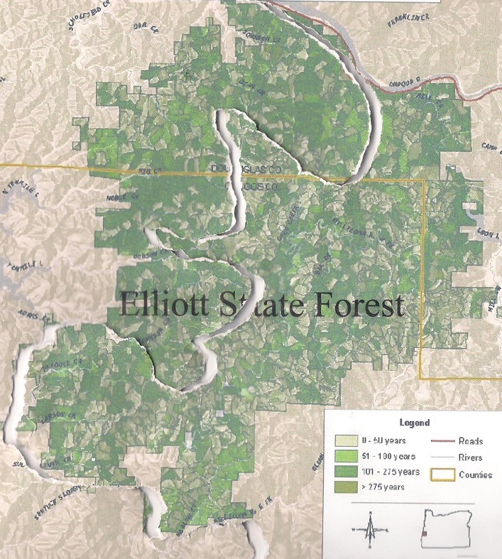
Pictures Tell the Story: OSU’s latest draft plan for the Elliott State Research Forest (ESRF) is an unwieldy mix of contradictions, obfuscation, and technical jargon put together by folks who clearly are not adept at communicating with a broader audience. When it comes to understanding this fundamental issue of compromise in the Elliott, pictures are the key.
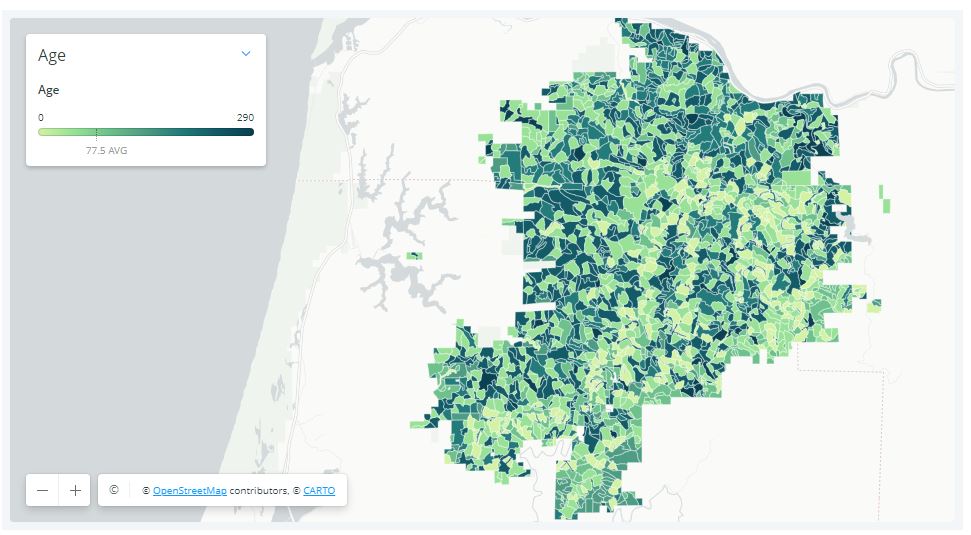
The map below shows the locations of older trees (indicated by darker shades of green) in the Elliott State Forest. It is important to note that significant quantities of older trees are scattered across vast stretches of the Forest.
Tree age classes in the Elliott State Forest (darker = older)
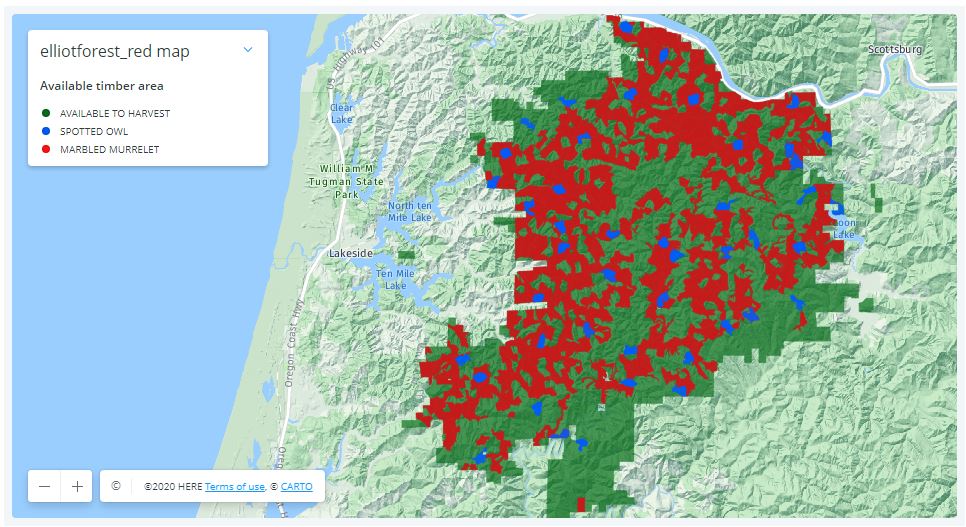
This next map shows the habitat of threatened birds (marbled murrelet in red and northern spotted owls in blue) in the Elliott. Predictably, the habitat is closely aligned with the older stands.
Habitat for threatened birds in the Elliott State Forest
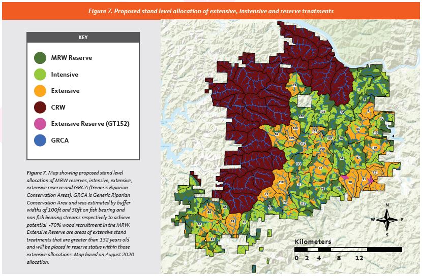
This final map shows how the OSU would divide the forest. The purple areas (denoted as “CRW”) would be “conservation research watersheds”, with limited logging allowed. The dark green areas (labeled as “MRW Reserve”) will be subject to experimental treatments (= logging) in the coming decades. The orange areas (labeled “Extensive”) will undergo thinning in which 20-80% of the trees are to be cut (including thousands of acres of older trees). The light green areas (labeled “Intensive”) are composed of trees less than 65 years of age, and will be subject to clearcutting.
OSU’s research design for the Elliott would perpetuate clearcutting or fragmentation in well over half the forest (conservation reserves shown in purple)
Viewed from the perspective of older trees and habit for our threatened birds, OSU’s plan for the Elliott is a complete disconnect. As the maps clearly show, it would sacrifice a majority of the Forest to continued clearcutting and fragmentation.
George Wuerthner’s eloquent words could not be more applicable to the Elliott:
“In far too many cases, there is a tendency to believe that it is necessary to appease local interests typically by agreeing to weakened protections or resource giveaways to garner the required political support for a successful conservation effort. However, this fails to consider that in nearly all cases where effective protective measures are enacted, it has been done over almost uniform local opposition.
In those instances where local opposition to a conservation measure is mild or does not exist, it probably means the proposal will be ineffective or worse—even set real conservation backward…Nevertheless, many environmentalists now believe that due to regional parochialism and lack of historical context, significant compromises are necessary to win approval for new conservation initiatives.“
The Elliott State Forest has already been heavily compromised – OSU’s plan would perpetuate the mistakes of the past.
The essence of OSU’s plan for the Elliott – the area on the west side would be protected, the area to the east would face continued fragmentation via a complicated matrix of “forest management” (including ~14,000 acres of clearcutting).