Editor’s note: Activists and environmentalists in the Philippines take extreme risks by speaking out to protect land and water. The Philippines has consistently been ranked as the most dangerous country in the world for environmental defenders. This story includes reference to 68-year-old environmental defender Daisy Macapanpan, who was arrested on what appear to be trumped-up charges for resisting the Ahunan pumped hydroelectric dam. This repression is merely the beginning.
Deep Green Resistance has collaborated with grassroots activists in the Philippines for many years. Some of our allies are involved in this fight, and are raising funds to print educational materials, hold events, and support community activism against the Ahunan hydro project by providing expertise, assisting in connections with lawyers, help getting international media coverage, and more. You can donate to these community organizers via PayPal to this email address. This story has not previously been reported in the international press.
MANILA — Casino billionaire Enrique Razon, one of the richest men in the Philippines, is planning a $1.1 billion hydropower dam which threatens Laguna De Bay, the largest lake in the nation and one of the largest in Southeast Asia, as well as the community of Pakil and rainforests on the flanks of the Sierra Madre mountains on the lake’s east bank.
Prime Infrastructure Capital corporation’s Ahunan Pumped-Storage Hydropower Project would destroy nearly 300 hectares of rainforest, leach toxic chemicals into Laguna De Bay, and could jeopardize the water supply for more than 20,000 residents of the area.
Local residents fear that the project could worsen typhoon flooding and lead to landslides, will destroy natural pools that are used in religious practices, and that the region’s frequent earthquakes could damage the dam and reservoir — which is planned to be built on Mt. Inumpong which rises above their community and that is riven by three major fault lines — leading to catastrophic failure.
Despite widespread community opposition, the project is set to break ground in 2023. Community organizers allege that illegal drilling is already taking place and that the Philippe army is guarding the site.
On June 11th, 68-year-old environmental defender Daisy Macapanpan, one of the leaders of the community opposition, was arrested in her home for “rebellion” after delivering a speech against the project. allegedly by 40 police officers with no warrant. She was released on August 10th on bail. Illegal detentions and arrests of environmentalists are common in the Philippines, which has also been ranked as the deadliest country for environmental defenders.
On August 8th, following extensive pressure from the communities and allegations of illegal conduct, the Municipal Councils and Chieftains of four directly impacted communities revoked a previous “no objection” resolution in favor of the project that had been in place since September 2021.
On August 23rd, the Department of Energy and Natural Resources Environmental Management Bureau and the community of Pakil dispatched representatives to investigate allegations on ongoing illegal construction.
Community organizers gathered in Pakil in August 2022 to resist the Ahunan hydroelectric dam project.
Pumped-storage hydropower is unlike regular hydropower dams, which block a river’s flow to produce electricity. Instead, pumped hydro storage (PHS) is an energy storage method. It depends on finding (or engineering) a site where two sizable reservoirs or natural water bodies at significantly different elevations can be connected by pipes. To store energy, operators pump water from the lower to the upper reservoir, and to use the stored energy, let it run back down through electrical power generation turbines.
According to the book Bright Green Lies: How the Environmental Movement Lost Its Way and What we Can Do About It, pumped-storage hydropower dams kill fish, distribute invasive species, destroy riparian vegetation and harm wetlands, decrease water quality, block aquatic migration, and contribute significantly to greenhouse gas emissions. The book also states that “these facilities lead to more fossil fuels being burnt” because of inefficiencies in the process.
The Ahunan Pumped-Storage Hydropower Project would produce 1,400 MW of electricity at full flow, none of which would go to the local community. Prime Infrastructure Capital corporation and the Philippines Department of Energy call the project “clean energy.”
The fish who live in Laguna De Bay are an important source of food for the 8.4 million people living in the surrounding communities. A petition to halt the project has been signed by more than 6,000 of the 15,000 voting-age residents closest to the proposed project.
The World Commission on Dams estimates that at least 40 million to 80 million people have been displaced by dams.
Editor’s note: Hydroelectric dams are not green energy, despite many claims that they are. Hydropower kills rivers, displaces millions of human beings, drives anadromous fish and other life dependent on free-flowing rivers extinct, and actually releases substantial greenhouse gasses. This post includes a short excerpt from Bright Green Lies as well as an article detailing a destructive dam proposal in Bolivia.
Dams are Not Green Energy
Excerpted from Chapter 11: The Hydropower Lie of Bright Green Lies: How the Environmental Movement Lost Its Way by Derrick Jensen, Lierre Keith, and Max Wilbert
Once upon a time, dams were recognized for the environmental atrocities they are. Human beings understood that dams kill rivers, from source to sea. They understood that dams kill forests, marsh- lands, grasslands.
In the 12th century, Richard the Lionhearted (King Richard I of England) put in place a law forbidding dams from preventing salmon passage. In the 14th century, Robert the Bruce did some- thing similar for Scotland. His descendant Robert the III went even further, declaring that three convictions for killing salmon out of season would be a capital offense.
Fast-forward to today, when dams are claimed to provide “clean” and “green” energy.
Where’s Robert the III when you need him?
As recently as three decades ago, at least environmentalists still consistently opposed dams. But the coup that turned so much environmentalism away from protecting the real world and into a lobbying arm of favored sectors of the industrial economy has rhetorically turned dams into environmental saviors. And climate change activists are among the most relentless missionaries for the gospel of the green dam.
This issue is urgent. While here in the United States, no new large dams have been built in many years (although many shovel-ready proposals are waiting for public funding), large hydropower dams are being built around the world as quickly as (in)humanly possible.
Once again, environmental engineer Mark Jacobson is an exam- ple, as he always seems to be, of someone working hard to kill the planet in order to save it. His 100 percent “renewable” transition plans—and remember, bright greens and many mainstream environmentalists love this guy—call for building about 270 new large hydroelectric dams globally, each at least the size of the Hoover or Glen Canyon dams.6 He also calls for major expansions to existing dams by adding new turbines. His models rely heavily on hydro because solar and wind facilities are by their nature intermittent and unreliable.
In Bolivia, Indigenous groups fear the worst from dam project on Beni River
More than 5,000 Indigenous people would be impacted by flooding from the construction of two dams in Bolivia, according to Indigenous organizations and environmentalists.
Successive governments have mulled the Chepete-El Bala hydroelectric project for more than half a century, and the current administration of President Luis Acre has now revived it as a national priority.
While Indigenous groups have successfully rejected the plan in the past, this time a group of 10 Indigenous organizations have signed an agreement with the state energy company approving feasibility studies.
If completed, the reservoirs for the project would cover a combined area larger than Bolivia’s capital, La Paz, and inundate an area that’s home to thousands of plant and animal species.
The Bolivian government has revived a long-held plan to build a hydroelectric plant in a corner of the country’s western La Paz department, sparking concerns about the potential displacement of more than 5,000 Indigenous people from the area.
The affected communities live in two protected areas, Madidi National Park and Pilón Lajas Biosphere Reserve and Communal Lands, parts of which would be flooded for the twin dams of the Chepete-El Bala hydroelectric project.
President Luis Arce, who served as minister of the economy in the earlier administration of Evo Morales, is following the same road map as his predecessor, who in July 2007 announced the original plans for the hydroelectric dams as a national priority.
Since 2018, there have been concerns that around 5,000 Indigenous people would be impacted by dam construction. Image courtesy of Chema Formentí.
The idea to generate hydropower in the Beni River Basin, specifically in El Bala Gorge, has been around for more than 50 years and given up on numerous times due to its economic unfeasibility and high environmental cost. The last time it was rejected by Indigenous communities was during the Hugo Banzer government in the late 1990s, before being nearly resurrected under Morales, Bolivia’s first Indigenous president.
Since then, the issue had largely faded for the six Indigenous communities that live in the area: the Mosetén, Tsiman, Esse Ejja, Leco, Tacana and Uchupiamona. The groups are now speaking out against the hydropower project, saying it would “cut off” the three rivers vital to their existence: the Beni and two of its tributaries, the Tuichi and Quiquibey.
“This would mean forced displacement and that means taking away our territory. We would be forced to leave our space, our ancestral domain,” said Alex Villca, a member of the National Coordinator for the Defense of Indigenous Peasant Territories and Protected Areas (Contiocap) of Bolivia. “We would be giving up what is most important: without territory there are no Indigenous peoples. This would be accepting a silent death. Wherever they take us, it would never be the same.”
The Indigenous leader said the problem goes even further. He said that in the Chepete mountains, some Indigenous peoples live in voluntary isolation — believed to be Mosetén, although there aren’t many studies to confirm this — and that they would be “totally” affected if the dams were constructed in the area. “We know from our brothers that there exists, in the peaks of the Chepete, a community in voluntary isolation that must be unaware of all these plans. Imagine how that would affect them if this project comes to fruition,” Villca said.
Tenders resumed
In 2021, Bolivia’s National Electric Energy Company (Ende) resumed the commissioning of the Chepete-El Bala project, announcing tenders for geological and geotechnical studies. The state-owned company said that in the case of the Chepete plant, the planned reservoir area would flood 46 square kilometers (18 square miles) of the total area of 3,859 square kilometers (1,490 square miles) of the Pilón Lajas reserve. The reservoir at El Bala, meanwhile, would cover 94 km2 (36 mi2) of the 18,895-km2 (7,295-mi2) Madidi park.
El Bala Gorge on the Beni River. Image courtesy of Chema Formentí.
In August, the Office of Indigenous Peoples of La Paz (Cpilap) signed an agreement with Ende authorizing the final design studies for the Chepete-El Bala project.
The agreement establishes that Cpilap must “allow the entry of Ende Corporation and its contracted companies to the areas of direct and indirect influence in order to carry out research, information gathering, socialization and data collection that allows studies, the creation of projects, to finalize the design to implement electric power generation, transmission and distribution.”
Villca spoke out against the signing of the agreement. “What worries us is that the tenor of the agreement is that it not only allows for complementary studies but also, in the future, allows Ende to start construction of the Chepete and El Bala hydroelectric plants. This is much more serious.”
Cpilap is a regional organization that brings together 10 Indigenous organizations in La Paz department: the Indigenous Council of the Tacana Peoples, the Office of the Indigenous Leco de Apolo, the Leco Indigenous People and Larecaja Native Communities, the Mosetén Indigenous Peoples Organization, the Indigenous Peoples of de San José de Uchupiamonas, the Esse Ejja of Eiyoquibo Indigenous Community, the Regional Council of T-simane Mosetén of Pilón Lajas, the Native Agroecological Community of Palos Blancos, the Tacana II Indigenous Communities of Rio Madre de Dios, and the Captaincy of the Araona Indigenous People. All of these organizations, according to Villca, are connected to Arce and Morales’s ruling party, the Movement for Socialism (MAS).
Gonzalo Oliver Terrazas, president of Cpilap, said five of the six affected Indigenous communities agreed with the hydropower project. The sixth community are the Mosetén, who didn’t sign the agreement. “This agreement doesn’t mean that the dam will be built,” he said. “The goal is to determine the feasibility or infeasibility of the project. Another important aspect that the agreement has is the social component, which we have included so that there can be electricity and housing projects.”
The Association of Indigenous Communities of the Beni, Tuichi and Quiquibey Rivers, an organization started in 2001 to defend the ancestral territories of the six Indigenous communities impacted by the project, has demanded that a prior consultation be carried out with the communities to approve or reject the project. The communities met over one weekend and decided to reject the government initiative, demonstrating that there are leaders for and against conducting feasibility studies for the project.
The hills of El Bala near the town of Rurrenabaque. Image courtesy of Chema Formentí.
“We remind [the government] that in 2016 there was a 12-day vigil and the expulsion of the Geodata and Servicons companies that had started work and studies in the territory without fulfilling a free, prior and informed consent [FPIC] consultation in good faith so as to receive the consent of the communities,” said a document published by the association.
Terrazas said the signing of the agreement with Ende doesn’t mean there won’t be consultation with Indigenous communities. He said that if the feasibility of the project is approved, a consultation will be carried out with the communities to approve or reject the construction of the hydropower plants.
In January 2018, Ende returned the prefeasibility study to the Italian company Geodata Engineering for correction. Geodata recommended “to postpone the development of the El Bala 220 hydroelectric plant until the conditions in the Bolivian energy market and abroad indicate that it is convenient to start its implementation.”
City-size reservoir
The project, which would start after a public tender is launched, would flood at least 662 km2 (256 mi2) of land for the two dams, according to Indigenous groups. Combined, the two reservoirs would cover an area five times bigger than Bolivia’s capital, La Paz. And if the dried-out salt lake of Poopó, in the department of Oruro, doesn’t recover, Chepete-El Bala would be the second-biggest lake in Bolivia after Titicaca.
The project calls for building the first dam in the Beni River’s Chepete Gorge, 70 km (43 mi) upstream from the town of Rurrenabaque, in the department of Beni, and the second near El Bala Gorge, 13.5 km (8.3 mi) upstream of the same town.
The town of Rurrenabaque, which would have two dams upstream. Image courtesy of Chema Formentí.
The Chepete dam would raise the water level to 158 meters (518 feet), forming a lake that would be 400 m (1,312 ft) above sea level. The dam at El Bala would raise the water level by 20 m (65 ft) and its reservoir would be 220 m (721 ft) above sea level. Unlike the Chepete dam, which would be a concrete wall, the dam at El Bala would consist of gates and generators in the middle of the river.
Extinction and displacement
According to the Solón Foundation, an environmental NGO, a total of 5,164 people would be relocated for the project, the majority of them Indigenous. The area is also home to 424 plant species of plants, 201 land mammals, 652 birds, 483 amphibians and reptiles, and 515 fish species. It’s not clear which species are most likely to go locally extinct as a result of the flooding, or how many would be affected.
The main fear of the Indigenous communities in the area is that the construction of both dams would mean forcibly displacing more than 5,000 residents. The construction of the second reservoir at El Bala, according to the Solón Foundation and Indigenous organizations opposed to the project, would flood the entire community of San Miguel del Bala. There’s no official information on a displacement plan for the communities more than 1,000 residents.
And with the construction of the Chepete reservoir, a little more than 4,000 Indigenous people would be displaced. All the populated areas affected by the reservoir, according to Geodata, have collective titles belonging to the Tacanas, Lecos and Mosetén peoples. Additionally, development on the river could interfere with the livelihoods of many residents, who fish and farm and, in more recent years, oversee communal tourism activities.
Chepete Gorge on the Beni River would be dammed to power a hydroelectric plant. Image courtesy of Alex Villca.
Valentín Luna is an Indigenous Tacana leader and head of the San Miguel del Bala community. Currently, there are at least 20 eco-lodges that have been built in the Madidi and Pilón Lajas protected areas. Most of these initiatives are managed by the local communities. Four of these eco-lodges would be flooded by the dams, according to Luna: one in Chalalán overseen by the Uchupiamonas, one run by San Miguel del Bala residents, one in Villa Alcira, and one run by the Chimanes and Mosetén of Asunción del Quiquibey.
For the Indigenous people who don’t want the dams in their area, the main worry isn’t the end of tourism. They fear that the six Indigenous groups will disappear along with it.
Banner image of Chepete Gorge on the Beni River, located 70 kilometers (43 miles) upstream of the village of Rurrenabaque. Image courtesy of Alex Villca.
A new study finds that as many as 26 dams could put the charismatic Amazon River Dolphin and the freshwater Tucuxi Dolphin at risk.
The research looked at whether particular Amazon dam projects would fragment dolphin populations and affect prey populations.
Though the public is fascinated by the Amazon’s dolphins, no one knows how many are currently left in the wild, or how the dam building frenzy will impact their numbers.
A dam-building boom is underway in the Amazon. More than 400 hydroelectric dams are in operation, being built, or planned for the river’s headwaters and basin. Scientists know that tropical dams disrupt water flow and nutrient deposition, with negative consequences for aquatic animals, especially migratory species. But little detailed knowledge exists as to the impacts of dams on specific species, or as to the best mitigations to prevent harm.
A recent study that tries to fill in that knowledge gap zeroes in on Brazil’s river dolphins. It found that as many as 26 dams could negatively impact dolphin populations and their prey.
The research, led by Dr Claryana Araújo of the Federal University of Goiás, Brazil, focused on two freshwater species: the Amazon River Dolphin, or boto (Inia geoffrensis), which is sometimes famously pink; and the Tucuxi (Sotalia fluviatilis).
The river dolphins of South America are charismatic emblems of rainforest biodiversity, and have captured the public imagination. Swimming in rivers, lagoons, and among submerged tree trunks in flooded forests to chase down prey, they can be found as far inland as the upper reaches of Amazonian tributaries, more than 2,600 kilometers (1,615 miles) from the Atlantic Ocean.
The two species inhabit Brazil, Peru, Ecuador, and Colombia, and in the case of the Amazon River Dolphin, Bolivia and Venezuela. Their ranges in Brazil extend beyond the limits of the Amazon basin, to include the Araguaia-Tocantins (for the Amazon River Dolphin) and North Atlantic watersheds (for both species).
Despite their status as flagship species in the region, both are classified as Data Deficient by the International Union for Conservation of Nature (IUCN) due to a current dearth of data. No one knows how many exist in the wild, or population trends over recent decades, and uncertainties remain regarding their ecology, and major threats to the species. This lack of baseline data leaves scientists and governments in the dark regarding the conservation measures needed, and puts the animals at greater risk.
Today, October 12th of 2024 –a symbolic date for Indigenous Peoples of this territory we call Abya Yala– we have gathered in these territories of resistance in the Isthmus of Tehuantepec, at the Continental Encounter Building an Alliance Against Gas Pipelines and Other Megaprojects in Defense of the Territories of Indigenous Peoples.
We are 374 delegates including representatives and spokespersons of Indigenous Peoples and organizations, environmentalists, people from the academia, communicators and free media journalists, coming from 20 states of the part of the Planet some call Mexico, 22 Indigenous Peoples and 11 countries, we have gathered in order to strengthen and amplify the alliances and networking initiatives of the Peoples of the Americas.
At this continental encounter, we speak out strongly against war and other forms of violence that are used as mechanisms to plunder the heritage of our peoples, and impossing megaprojects to make it happen. This violence manifests –in the harshest and most brutal ways– as what is happening right now to the Palestinian People –and the full regional war in the Middle East– and also the criminalization of water, land, air and life protectors in all our countries.
We demand the cessation of the violation of Nature rights, and we denounce and oppose the role of international banking that finances megaprojects that threaten all life.
Today marks 532 years of Indigenous, Black and Peoples resistance. Despite the vicious and destructive capitalism, in the face of the countless attempts to erase our ancestral culture and the militarization of our territories and geographies, and in spite of the false well-being that governments preach, we all declare from here –the Isthmus of Tehuantepec– that we stand strong celebrating life with dignity and a rebellious indomitable spirit.
In this encounter we have agreed to foster –together with our brothers and sisters from the North, Meso and South America– the efforts to walk together to defend our rights and territories. We condemn the imposition of these megaprojects of death and, in particular, gas pipelines, such as those in Tuxpan, Tula and La Puerta del Sureste, which cause serious environmental damage and threaten the lives and culture of our peoples.
We, the women participating in this encounter –as guardians of the territory, the land and the life of our peoples– reflect with concern about the future of new generations, of our children, as well as the need to make visible the pain generated by imposition, and by the dispossession of the natural resources and the territory of our peoples. We emphasize the importance to encourage relationships based on sisterhood, empathy, care and support each other among ourselves, as well as to foster mutual respect with our fellow life protectors. We salute the brave struggle of our sisters throughout the continent who mobilize for women and our peoples rights.
It is essential for the movements of our peoples to strengthen actions regarding community and popular communication. It is our challenge to break the media siege, through which the great (state- corporate)powers seek to make our struggles invisible. Therefore, we call on our peoples’ communicators to foster a great continental outreach initiative that contributes to strengthening the processes of unity.
We denounce any boost of neoliberal programs by the governments of our continent. These governments are acting in the interests of large transnational corporations and –to fulfill their needs– criminalize protectors of our territories.
This is why this encounter is calling for the release of our political and consciousness prisoners like: Leonard Peltier, Chief Dhstayl (Adam Gagnon), Kenia Hernandez, Tomás Martínez Mandujano, Emiliano Zambrano Aguilar, Arnulfo García Santos (from the Triqui People); and many other protectors of the Earth Family.
We demand to see alive our relatives Sergio Rivera, the 43 student teachers from Ayotzinapa, Sandra Estefanía Dominguez, Claudio Uruchurtu, Ernesto Sernas García, Estefanía Domínguez Martínez and many, many, many more.
We demand transformative justice for the murderers of Samir Flores, Noe Jiménez Pablo, José Santiago Gómez, Luis Armando Fuentes Aquino, Jesús Manuel García Martínez, Felix Vicente Cruz, Juan López, and the comrades of the Popular Union of Street Vendors “October 28”. We want justice for Bety Cariño and Jyri Jaakkola, 14 years after their assassinations. We demand an end to the persecution of our brothers and sisters of UCIZONI, Puente Madera and other communities, who have been criminalized for protecting their territory against the megaproject of the Interoceanic Corridor in the Isthmus of Tehuantepec. We urge to put an end to the criminalization and harassment of Cholulteca and volcanoes peoples in Puebla, so as the defenders of the territory against the so-called “Mayan Train” megaproject. We also denounce the governments that persecute water and land protectors who confront the Canadian pig farm corporation Granjas Carroll. We demand the cancellation of the Las Cruces hydroelectric megaproject in Nayarit, in the part of the Planet some call Mexico, because it threatens the sacred sites of the Naáyari, Wixarika, Odham and Meshika peoples, damming the last free river in Mexico. We demand an end to the persecution and criminalization of people living in poverty for their skin color and way of dressing. We ask fair treatment to our fellow migrant relatives. And we reject and denounce the use of the organized crime and government agreements with drug cartels as a way to attack and assault people’s movements.
We have agreed to boost legal prevention strategies, and we urge peoples and municipalities to carry out their own consultation protocols and municipal and regional statements. So that we all can have, in our own geographies, declarations of territories free from (mountain-top removal)mining, fossil fuel industry, damming of our rivers, (reckless industrial)farm wind, industrial parks, and toxic waste dumps projects.
We send our deep and respectful greetings to the National Indigenous Congress, on the 28th anniversary of its birth today, and we recognize its struggle as the main reference for the mobilization of the Indigenous Peoples in these bioregions. We also greet our sisters and brothers who are mobilizing today in Tepic, Mexico City, El Salvador and Guatemala, and we recognize and deeply appreciate the contribution and solidarity of our relatives from the parts of the Planet we call Switzerland, Germany, France, Canada and the United States who all have expressed their willingness to be a close companionship in our struggles.
532 years of indigenous, black and popular resistance. Long live the resistance of our peoples!
Long live the organized continental struggle!
Not one more isolated struggle!
Continental Encounter Building an Alliance Against Gas Pipelines and other Megaprojects in Defense of the Territories of Indigenous Peoples.
Yajxonax Agroecology Center, Tierra Bonita, Isthmus of Tehuantepec, Oaxaca, Part of the Planet some call Mexico.
*Yajxonax means “Beautiful Land” in Ayuujk (or Mixe) language.
In 1915, General Electric released a silent promotional film titled The Home Electricaloffering a glimpse into a gleaming, frictionless future. The film walks viewers through a model electric home: lights flicked on at the wall, meals cooked without fire, laundry cleaned without soap and muscle. A young wife smiles as she moves effortlessly through her day, assisted by gadgets that promised to eliminate drudgery and dirt. This was not a documentary—it was a vision, a fantasy, a sales pitch. At the time, only a small fraction of American households had electricity at all, and nearly 90% of rural families still relied on oil lamps, wood stoves, hand pumps, and washboards. But the message was clear: to be modern was to be electric—and anything less was a kind of failure.
At the dawn of the 20th century, electricity was still a symbol of wealth, not a tool of survival. Most urban households that had it used it only for lighting; refrigeration, electric stoves, or washing machines were luxuries among luxuries. In rural America, most farms and small towns remained off-grid through the 1920s. The electric grid simply didn’t go there. Private utilities, driven by profit, had no interest in building costly infrastructure where it wouldn’t quickly pay off.
And yet, propaganda told a different story. In magazines, World’s Fairs, and promotional pamphlets, electricity was shown as the cornerstone of health, cleanliness, efficiency, and modern womanhood. Electric appliances promised to save time, reduce labor, and lift families—especially women—into the new century. But this future was just out of reach for most people. A growing divide opened up: between those who lived by the rhythms of sun and fire, and those whose lives were quietly reshaped by the flick of a switch.
To live without electricity meant pumping water by hand, chopping and hauling wood for heat and cooking, cleaning clothes with a washboard, and preserving food with salt, smoke, or ice if you had it. It meant darkness after sundown unless you had oil or candles. These were difficult, time-consuming tasks—but also deeply embedded in older, place-based ways of life. People were less dependent on centralized systems. They mended clothes instead of buying new ones, and their food came from the land, not refrigerated trucks.
Yet the narrative of “progress” didn’t tolerate this complexity. By the 1920s and ‘30s, utilities and appliance manufacturers framed non-electric life as backward, dirty, and even unpatriotic. Their message: to be modern was to be electric.
This vision of electrified modernity wasn’t just implicit; it was relentlessly promoted through the dazzling spectacles of world’s fairs and the persuasive language of print advertising. Electricity was framed not only as a technological advance but as a moral and social imperative—a step toward cleanliness, order, and even national progress. At places like the 1904 St. Louis World’s Fair, entire palaces were built to glorify electricity, their glowing facades and futuristic interiors turning utility into fantasy. Meanwhile, companies like Western Electric and General Electric saturated early 20th-century magazines with ads that equated electric appliances with a better life—especially for women. These messages didn’t merely advertise products; they manufactured desire, anxiety, and aspiration. To remain in the dark was no longer quaint—it was backward.
At the 1904 St. Louis World’s Fair, the Palace of Electricity was more than an exhibit—it was theater. Illuminated by thousands of electric bulbs, the building itself was proof of concept: a monument to the power and promise of electrification. Inside, visitors encountered displays of the latest electric appliances and power systems, all framed as marvels of human ingenuity. Nearby, the Edison Storage Battery Company showcased innovations in energy storage, while massive dynamos hummed behind glass. The fair suggested not just that electricity was useful, but that it was destiny.
Louisiana purchase exposition, St. Louis, 1904. The Library of Congress, via Wikimedia Commons.
This theatrical framing of electricity as progress carried into everyday life through print advertisements. A 1910 issue of Popular Electricity magazine illustrated a physician using electric light in surgery, suggesting that even health depended on electrification. In a 1920 ad for the Hughes Electric Range, a beaming housewife is pictured relaxing while dinner “cooks itself,” thanks to the miracle of electricity. Likewise, a Western Electric ad from the same year explained how to build an “electrical housekeeping” system—one that offered freedom from drudgery, but only if the right appliances were purchased.
These messages targeted emotions as much as reason. They played on fears of being left behind, of being an inadequate housewife, of missing out on modernity. Electricity was no longer merely about illumination—it became a symbol of transformation. The more it was portrayed as essential to health, domestic happiness, and national strength, the more it took on the aura of inevitability. A home without electricity was not simply unequipped; it was a failure to progress. Through ads, exhibits, and films, electricity was sold not just as a convenience, but as a moral good.
And so the groundwork was laid—not only for mass electrification, but for the idea that to live well, one must live electrically.
Before the Toaster: Industry was the First Beneficiary of Electrification
While early 20th-century advertisements showed electricity as a miracle for housewives, the truth is that industry was the first and most powerful customer of the electric age. Long before homes had refrigerators or lightbulbs, factories were wiring up to electric motors, electric lighting, and eventually, entire assembly lines driven by centralized power. Electricity made manufacturing more flexible, more scalable, and less tied to water or steam—especially important in urban areas where land was tight and labor plentiful.
By the 1890s, industries like textiles, metalworking, paper mills, and mining were early adopters of electricity, replacing steam engines with electric motors that could power individual machines more efficiently. Instead of a single massive steam engine turning shafts and belts throughout a factory, electric motors allowed decentralized control and faster adaptation to different tasks. Electric lighting also extended working hours and improved productivity, particularly in winter months.
Electrification offered not just operational efficiency but competitive advantage—and companies knew it. By the 1910s and 1920s, large industrial users began lobbying both utilities and governments for better access to power, lower rates, and more reliable service. Their political and economic influence helped shape early utility regulation and infrastructure investment. Many state utility commissions were lobbied heavily by industrial users, who often negotiated bulk discounts and prioritized service reliability over residential expansion.
This dynamic led to a kind of two-tiered system: electrification for factories was seen as economically essential, while electrification for homes was framed as aspirational—or even optional. In rural areas especially, private utilities refused to extend lines unless they could first serve a profitable industrial customer nearby, like a lumber mill or mine.
Meanwhile, companies that produced electrical equipment—like General Electric, Westinghouse, and Allis-Chalmers—stood to gain enormously. They pushed for industrial electrification through trade shows, engineering conferences, and direct lobbying. Publications like Electrical World and Power magazine ran glowing stories about new industrial applications, highlighting speed, productivity, and cost savings. GE and Westinghouse didn’t just sell light bulbs and home gadgets—they also built turbines, dynamos, and entire systems for industrial-scale customers.
And industry didn’t just demand electricity—industry helped finance it. Many early power plants, particularly in the Midwest and Northeast, were built explicitly to serve one or more large factories, and only later expanded to provide residential service. These plants often operated on a model of “load factor optimization”: power usage by factories during the day and homes at night ensured a steady demand curve, which maximized profits.
By the 1920s, the logic was clear: industry came first, homes came second—but both served the larger vision of an electrified economy. And this industrial-first expansion became one of the justifications for public electrification programs in the 1930s. If electricity had become so essential to national productivity, how could it remain out of reach for most rural Americans?
Niagara Falls Power Plant: Built for Industry
In 1895, the Niagara Falls Power Company, led by industrialist Edward Dean Adams and with technological help from Westinghouse Electric and Nikola Tesla, completed the Adams Power Plant Transformer House—one of the first large-scale hydroelectric plants in the world.
Eight of the ten 1,875 kW transformers at the Adams Power Plant Transformer House, 1904, public domain
This plant didn’t exist to power homes. Its primary purpose was to serve nearby industries: electrochemical, electrometallurgical, and manufacturing firms that required vast amounts of energy. The ability to harness hydropower made Niagara Falls a magnet for energy-intensive factories.
Founded in 1891, Carborundum relocated to Niagara Falls in 1895 to take advantage of the abundant hydroelectric power. They manufactured silicon carbide abrasives, known as “carborundum,” using electric furnaces that operated at high heat. The company was the second to contract with the Niagara Falls Power Company, underscoring the plant’s role in attracting energy-intensive industries.
The promise of abundant cheap power made Niagara Falls the world capital of electro-chemical and electro-metallurgical industries, which included such companies as the Aluminum Company of America (ALCOA), Carborundum (which developed the world’s hardest abrasive as well as graphite), Union Carbide, American Cyanamid, Auto-Lite Battery, and Occidental Petroleum. These were enterprises that depended upon abundant cheap power. At its industrial peak, in 1929, Niagara Falls was the leading manufacturer in the world of products using abrasives, carbon, chlorine, and ferro-alloys.
In the late 19th and early 20th centuries, Niagara Falls became a hub for industrial activity, primarily due to its abundant hydroelectric power. The establishment of the Niagara Falls Power Company in 1895 marked the beginning of large-scale electricity generation in the area. This readily available power attracted energy-intensive industries, including aluminum production, electrochemical manufacturing, and abrasives. Companies like the Pittsburgh Reduction Company (later Alcoa) and the Carborundum Company set up operations to capitalize on the cheap and plentiful electricity.
Even food companies jumped on the opportunity for abundant electricity. The founder of the Shredded Wheat Company (maker of both Shredded Wheat and Triscuit), Henry Perky, built a large factory directly at Niagara Falls, choosing the site precisely because of its access to cheap, abundant hydroelectric power. When the Triscuit cracker was first produced in 1903, the factory was powered entirely by electricity—a key marketing point. Early ads bragged that Triscuits were “Baked by Electricity,” which was a novel and futuristic idea at the time.
However, this rapid industrial growth came at a significant environmental cost. The freedom afforded to early industry in Niagara Falls meant that area waterways became dumps for chemicals and other toxic substances. By the 1920s, Niagara Falls was home to a dynamic and thriving chemical sector that produced vast amounts of industrial-grade chemicals via hydroelectric power. This included the production of chlorines, degreasers, explosives, pesticides, plastics, and myriad other chemical agents.
The success at Niagara set a precedent: electricity could fuel industrial expansion, and factories began lobbying for access to centralized electric power. States and cities recognized that electrification attracted investment, jobs, and tax revenue. This created political pressure to expand grids and build new generation capacity—not to homes first, but to industrial parks and cities with manufacturing bases.
The environmental impact was profound. In 1986, Canadian researchers discoveredthat the mist from the falls contained cancer-causing chemicals, leading both the U.S. and Canada to promise cleanup efforts. Moreover, the Love Canal neighborhood in Niagara Falls became infamous for being the site of one of the worst environmental disasters involving chemical wastes in U.S. history. The area was used as a dumping ground for nearly 22,000 tons of chemical waste, leading to severe health issues for residents and eventual evacuation of the area.
This historical example underscores the complex legacy of electrification—while it spurred industrial advancement and economic growth, it also led to environmental degradation and public health crises.
The Salesman of the Grid: Samuel Insull and the Corporate Vision of a Public Good
Even as electricity was still being marketed as a lifestyle upgrade—offering clean kitchens, lighted parlors, and “freedom from drudgery”—Samuel Insull was reshaping the electrical industry behind the scenes in ways that would bring electricity to both homes and factories on an unprecedented scale. A former secretary to Thomas Edison, Insull became the president of Chicago Edison (later Commonwealth Edison) and transformed the electric utility into a regional power empire. He championed centralized generation, long-distance transmission, and, most importantly, load diversity: the idea that combining industrial and residential customers would create a steadier, more profitable demand curve.
Industry, after all, consumed massive amounts of electricity during the day, while households peaked in the evenings. By blending these demands, utilities could justify larger power plants that ran closer to capacity around the clock—making electricity cheaper to produce per unit and more profitable to sell.
Insull’s holding companies and financial structures helped finance this expansion, often using consumer payments to support new infrastructure. This helped expand the grid outward—to serve not just wealthy homes and big factories, but small towns and middle-class neighborhoods. Electrification became a virtuous cycle: the more customers (especially industrial ones) you had, the more power you could afford to generate, which brought in more customers. The industrial appetite for power and the domestic aspiration for comfort were two sides of the same system.
By the early 20th century, Insull had consolidated dozens of smaller electric companies into massive holding corporations, effectively inventing the modern utility monopoly. His genius wasn’t technical but financial: he pioneered the use of long-term bonds and ratepayer-backed financing to build expansive infrastructure, including coal-fired power plants and transmission lines that could serve entire cities and suburbs.
Insull also understood that to secure profits, electricity had to become not a luxury, but a public necessity. He lobbied for—and helped shape—state-level utility commissions that regulated rates but guaranteed companies a return on investment. He promoted a pricing model in which larger customers subsidized smaller residential ones, making electricity seem affordable while expanding the customer base. In speeches and newspaper campaigns, Insull insisted that electricity was a public service best delivered by private enterprise—so long as that enterprise was shielded from competition and supported by the state.
But Insull’s vision had limits. His business model was urban, corporate, and capital-intensive. It thrived in cities where growth and profits were assured—but left rural America behind. Even by the late 1920s, nearly 90% of rural households still had no electricity, and private utilities had little interest in changing that. When Insull’s financial empire collapsed during the Great Depression—leaving thousands of investors penniless—it triggered a wave of backlash and set the stage for Roosevelt’s 1930s public electrification programs.
The failure of Insull’s empire didn’t just expose the risks of private monopolies; it also reframed electricity as too essential to be left entirely in corporate hands. If the promise of electrification was to reach beyond city limits, it would take more than advertising. It would take state power.
Electricity as a Public “Good”
Franklin D. Roosevelt’s New Deal ushered in that power—both literally and figuratively. Federal programs like the Tennessee Valley Authority (TVA), the Rural Electrification Administration (REA), and the Works Progress Administration (WPA) tackled electrification as a national mission. The TVA aimed to transform one of the poorest regions in the country through public power and flood control. The REA extended loans to rural cooperatives to build distribution lines where private utilities refused to go. The WPA, though more broadly focused on employment and infrastructure, supported the building of roads, dams, and even electric grids that tied into the new public utilities.
But these were not just engineering projects—they were nation-building efforts, wrapped in the language and imagery of progress. Government-sponsored films, posters, and exhibits cast electrification as a patriotic duty and a moral good. In The TVA at Work (1935), a TVA propaganda film, darkness and floods give way to light as electricity reaches the rural South, promising flood control, education, health, and hope.
Posters issued by the REA featured glowing farmhouses surrounded by darkness, their light a beacon of the federal government’s benevolence. Electrification was no longer a luxury product to be sold—it was a public right to be delivered. And propaganda helped recast the electric switch as not just a convenience, but a symbol of democratic progress.
In the early decades of the 20th century, the business of providing electricity was largely in private hands, dominated by powerful industrialists who operated in a fragmented and often exploitative landscape. Rates varied wildly, service was inconsistent, and rural areas were left behind entirely. Out of this chaos emerged a slow, contested movement to treat electricity not as a luxury good for profit but as a regulated public utility—something closer to a right.
Roosevelt’s electrification programs—especially the TVA and the REA—aimed to provide public benefits rather than private profit. But in reality, most rural Americans didn’t vote on where dams and coal-fired power plants would go, how the landscape would be transformed, or who would manage the power. The decision-making remained highly centralized, and the voice of the people was filtered through federal agencies, engineers, and bureaucrats. If this was democracy, it was a technocratic form—focused on distributing benefits, not sharing power.
Still, for many rural communities, the arrival of electricity felt like democratic inclusion: a recognition by the federal government that their lives mattered too. New Deal propaganda leaned into this feeling. Posters, pamphlets, and films portrayed electrification as a patriotic triumph—uniting the country, modernizing the nation, and bringing light to all Americans, not just the urban elite.
FDR fiercely criticized utility companies for their opposition to these efforts. In one speech, he called out their “selfish purposes,” accusing them of spreading propaganda and corrupting public education to protect their profits. His administration’s Public Utility Holding Company Act of 1935 was designed to break up massive utility holding companies, increase transparency, and limit the abusive practices that had flourished under Insull’s system.
By the end of the 1930s, electricity had changed in the eyes of the law and the public. It was no longer a commodity like soap or phonographs. It was essential—a regulated utility, under public scrutiny, increasingly expected to reach all people regardless of profit margins.
How Rural Communities Organized for Electricity
Reaching everyone required more than federal mandates; it required rural people—many of whom had never flipped a light switch—to believe electricity was not just possible, but necessary. New Deal propaganda didn’t just promote electrification; it made it feel like a patriotic obligation. In posters, films, and traveling exhibits, electricity was depicted as a force of national renewal, radiating from power plants and wires like sunlight over a darkened land. Farmers who had once relied on kerosene lanterns saw glowing visions of electric barns, modern kitchens, and clean, running water. The message was clear: this wasn’t charity—it was justice.
The REA offered low-interest loans to communities willing to organize themselves into cooperatives. But before wires could be strung, people had to organize—drawing maps, knocking on doors, pooling resources. That kind of coordination didn’t happen spontaneously. It was sparked, in large part, by persuasive media.
REA films like Power and the Land (1940) dramatized the transformation of farm life through electricity. Traveling REA agents brought these short films and illustrated pamphlets to town halls, church basements, and grange meetings, showing everyday people that their neighbors were already forming co-ops—and thriving. REA’s Rural Electrification News magazine featured testimonials from farm wives, who praised electric irons, cream separators, and the ability to read after sunset. Electrification wasn’t just about comfort; it was about dignity and opportunity.
A TVA poster from the period shows power lines bringing power for farm fields, homes, and factories. The subtext was unmistakable: electricity was the pulse of a modern democracy. You didn’t wait for it. You organized for it.
And people did. Between 1935 and 1940, rural electrification—driven by this blend of policy and persuasion—expanded rapidly. By 1940, more than 1.5 million rural homes had electricity, up from barely 300,000 just five years earlier. The wires came not just because the government built them, but because people demanded them, formed cooperatives, and rewired their lives around a new kind of infrastructure—one they now believed they deserved.
When FDR created the REA in 1935, fewer than 10% of rural homes had electricity. By 1953, just under two decades after the REA’s launch, over 90% of U.S. farms had electric service, much of it delivered through cooperatives that had become symbols of rural self-determination.
The Federal Power Act
In 1935, the same year Roosevelt signed executive orders establishing the Rural Electrification Administration, Congress passed the Federal Power Act—an often-overlooked but foundational shift in how electricity was governed in the United States. At the time, only about 60% of American homes had electricity, and the vast majority of rural households remained off the grid. Industry was rapidly becoming reliant on continuous, 24/7 electric power to run increasingly complex machinery and production lines, making reliable electricity essential not just for homes but for the nation’s economic engine.
The Act expanded the jurisdiction of the Federal Power Commission, granting it authority to regulate interstate transmission and wholesale sales of electricity. This marked a decisive move away from the era of laissez-faire monopolies toward public oversight. Industry players, eager for dependable and affordable power to sustain growth and competition, played a subtle but important role in pushing for federal regulation that would stabilize the market and ensure widespread, reliable access. The Act framed electricity not as a luxury commodity but as a vital service that required accountability and coordination. In tandem with the New Deal electrification programs, it laid the legal groundwork for treating electricity as a public good—setting the stage for how electricity would be mobilized, mythologized, and mass-produced during wartime.
Electricity as Patriotic Duty
By the end of the 1930s, electricity had changed in the eyes of the law and the public. It was no longer a commodity like soap or phonographs. It was essential—a regulated utility, under public scrutiny, increasingly expected to reach all people regardless of profit margins.
But as the nation edged closer to war, the story of electricity changed again. The gleaming kitchens and “eighth wonder of the world” dams of New Deal posters gave way to a new message: power meant patriotism. Electricity was no longer just a household convenience or symbol of rural uplift—it was fuel for victory.
Even before the U.S. formally entered World War II, government and industry launched campaigns urging Americans to think of their energy use as a form of service. Factories were electrified at full tilt to produce planes, tanks, and munitions. Wartime posters and advertisements called on citizens to “Do Your Part”—to conserve power at home so it could be redirected to the front. Lights left on unnecessarily weren’t just wasteful; they were unpatriotic.
One striking 1942 poster from the U.S. Office of War Information featured a light switch with the message: “Switch off that light! Less light—more planes.” Another encouraged energy conservation by asking people to switch lights off promptly because “coal is vital to victory” (at this time 56% total electricity on U.S. grids was generated by coal).
For women, especially, electricity was again positioned as a moral responsibility. Earlier ads had promised electric gadgets to free housewives from drudgery; now, propaganda reminded them that their efficient use of electric appliances was part of the national war strategy. The same infrastructure built by New Deal programs now helped turn the rural power grid into an engine of military supply.
Electricity had become inseparable from national identity and survival. To use it wisely was to serve the country. To waste it was to betray the war effort. This was no longer a story of gadgets and progress—it was a story of sacrifice, duty, and unity under the banner of light.
Nowhere was this message clearer than in the materials produced by the Bonneville Power Administration (BPA), which managed the massive hydroelectric output of the Columbia River dams in the Pacific Northwest. In the early 1940s, the BPA commissioned a series of posters to dramatize the link between public power and wartime production. One of the most iconic, “Bonneville Fights Time,” shows a welder in a protective mask, sparks flying, framed by dynamic lines of electricity and stylized clock hands. The message: electric power enabled faster, more precise welding—crucial for shipbuilding, aircraft, and munitions production.
The poster’s bold composition connected modernist design with national urgency. Bonneville’s electricity wasn’t just flowing to light bulbs—it was flowing to the war factories of the Pacific coast, to the shipyards of Portland and Seattle, and to the aluminum plants that turned hydroelectric power into lightweight warplanes. These images promoted more than technical efficiency; they sold a vision of democratized power mobilized for total war.
Through such propaganda, the promise of public power was reimagined—not just as a civic good, but as a weapon that could help win World War II.
Electrifying the American Dream
When the war ended, the messaging around electricity shifted again—from sacrifice to surplus. Wartime rationing gave way to a marketing explosion, and the same electrified infrastructure that had powered victory was now poised to power prosperity. With factories retooled for peace-time commerce, and veterans returning with GI Bill benefits and dreams of suburban life, the home became the new front line of American identity—and electric gadgets were its weaponry.
The postwar boom fused electricity with consumption, convenience, and class mobility. Advertisements no longer asked families to conserve power for the troops; they encouraged them to buy electric dishwashers, toasters, vacuum cleaners, televisions. Owning a full suite of appliances became a marker of success, a tangible reward for patriotism and patience. Electricity was no longer just a utility—it was the lifeblood of modern living, sold with the same glamour and intensity once reserved for luxury cars or perfumes.
Utilities and manufacturers teamed up to keep the vision alive. The Live Better Electrically campaign, launched in 1956 and endorsed by celebrities like Ronald Reagan, urged Americans to “go all-electric”—not just for lighting and appliances, but for heating, cooking, and even air conditioning. The campaign painted a glowing picture of total electrification, backed by images of smiling housewives, sparkling kitchens, and obedient gadgets. In one ad, a mother proudly paints a heart on her electric range as her children and husband laugh and smile. The future, once uncertain, had been domesticated.
Nowhere was the all-electric ideal more vividly branded than in the Gold Medallion Home, a product of The Live Better Electrically campaign. These homes were awarded a literal gold medallion by utilities if they met a full checklist: electric heat, electric water heater, electric kitchen appliances, and sufficient wiring to support a future of plugged-in living. Promoted through glossy ads and celebrity endorsements, the Medallion Home symbolized upward mobility, domestic modernity, and patriotic participation in a high-energy future. It was a propaganda campaign that blurred the line between consumer aspiration and infrastructure planning. Today’s “electrify everything” efforts—encouraging heat pumps, EVs, induction stoves, and smart panels—echo this strategy. Once again, homes are being refashioned as sites of technological virtue and national progress, marketed through a familiar mix of lifestyle promise and utility coordination. The medallion has changed shape, but the message remains: the future lives here.
This was propaganda of abundance. And behind it was an unspoken truth: electrification had won. What had once been sold as fantasy—glimpsed in world’s fair palaces or GE films—was now embedded in daily life. The flick of a switch no longer symbolized hope. It had become habit.
Ruralite
Ruralite magazine serves as the flagship publication of Pioneer Utility Resources, a not-for-profit communications cooperative to serve the rural electric cooperatives (or co-ops) across the western United States. It was—and remains—a shared publication platform for dozens of small, locally owned utility co-ops that formed in the wake of the REA.
Each electric co-op—often based in small towns or rural counties—can customize part of the magazine with local news, board updates, outage reports, and community features. But the bulk of the magazine is centrally produced, offering ready-made content: stories about electric living, energy efficiency, co-op values, new technologies, and the benefits of belonging to a cooperative utility system.
In this sense, Ruralite functions as a kind of regional PR organ: a hybrid of lifestyle magazine, customer newsletter, and soft-sell propaganda tool. It is funded by and distributed through electric co-ops themselves, landing monthly in the homes of hundreds of thousands of rural residents.
Though it debuted in 1954—well after the apex of New Deal electrification programs—Ruralite can be seen as a direct descendant of that era’s propaganda infrastructure, repackaged for peacetime and consumer prosperity. The TVA had its posters, the REA had its pamphlets, and Ruralite had glossy photo spreads of farm wives with gleaming electric ranges.
Where New Deal propaganda had rallied Americans to support rural electrification as a national project of fairness and modernity, Ruralite shifted the tone toward comfort, aspiration, and consumer loyalty. It picked up the baton of electrification as cultural transformation, reinforcing the idea that electric living wasn’t just a right—it was the new rural ideal.
Clipped from “For the Curious Ruralite,” tips to encourage electricity use from the December 1954 edition of Ruralite Magazine
Ruralite framed rural electrification not as catching up to the cities, but as leading the way in a new era—one where rural values, ingenuity, and resourcefulness would power the country forward. In this way, co-ops and their members became symbols of progress, not just beneficiaries of it.
This was propaganda not by posters or patriotic slogans, but through community storytelling. Ruralite grounded its messaging in local personalities, recipes, and relatable anecdotes, while embedding calls to adopt more appliances, update homes, and trust in the local co-op as a benevolent, forward-looking institution.
The first Ruralite recipe, for which you need an electric refrigerator, published in Ruralite Magazine, June 1954. Clipped from this June 1, 2024 article.
Today, Ruralite remains rooted in local storytelling, but its tone aligns more with contemporary consumer lifestyle media. Sustainability, renewables, and energy efficiency now appear alongside nostalgic rural features and recipes. Yet despite the modern packaging, the core narrative remains consistent: electricity is integral to the good life. That through-line—from a beacon of modernization to a pillar of local identity—demonstrates how the publication has adapted without abandoning its propagandistic roots.
In the current energy landscape, Ruralite plays a quiet but significant role in advancing the “electrify everything” agenda—the 21st-century push to decarbonize buildings, transportation, and infrastructure by transitioning away from fossil fuels to electric systems.
While Ruralite doesn’t use overtly political language, it steadily normalizes new electric technologies like heat pumps, EVs, induction stoves, and solar arrays. Features on homeowners who upgraded to electric water heaters, profiles of co-ops launching EV charging stations, or DIY guides for energy audits all reinforce the idea that the electric future is practical, responsible, and here. The message is aspirational but grounded in small-town pragmatism: this isn’t Silicon Valley hype—it’s your neighbor electrifying their barn or replacing a propane furnace or reminiscing about life without electricity.
Ruralite continues the legacy of New Deal-era propaganda by promoting ever-greater electricity use—now through electric vehicles and heat pumps instead of fridges and space heaters—reinforcing the idea that progress always means more power, more consumption, and more infrastructure. Its storytelling still serves a strategic function—ensuring electricity remains not just accepted, but desired, in every American home.
Postwar Peak and Decline of Electrification Propaganda
By the 1960s, most American homes—urban and rural—had been electrified. The major battle to electrify the country was won. As a result, the overt electrification-as-progress propaganda that had dominated the New Deal era and postwar boom faded. Electricity became mundane: a background utility, no longer something that needed to be sold as revolutionary.
During the 1970s and early 1980s, the focus of public discourse shifted toward energy crises and conservation. Rather than expanding electrification, the government and utilities started encouraging Americans to use less, not more—a notable, if temporary, reversal. The 1973 oil shock, Three Mile Island (1979), and rising distrust in institutions tempered the earlier utopian energy messaging.
1970’s energy conservation poster, via Low Carbon Institute, in the personal collection of Russell Davies.
However, electrification propaganda never vanished entirely. It just narrowed. Publications like Ruralite and utility co-ops continued localized campaigns, pushing upgrades (like electric water heaters or electric stoves) in rural areas and maintaining a cultural narrative of electric life as modern and efficient.
The Renewables-Era Revival of Electrification Propaganda
In the late 1990s and especially the 2000s, a new wave of electrification propaganda began to emerge, but this time under the banner of climate action. Instead of promoting electricity as luxury or convenience, the new message was: electrify everything to save the planet.
This “green” electrification push encourages:
Electric vehicles (EVs) to replace gasoline cars
Heat pumps to replace fossil fuel heating systems
Induction stoves over gas ranges
Grid modernization and massive renewable build-outs (wind, solar, batteries)
Glossy, optimistic, uncritical propaganda pushing electricity from Ruralite Magazine, December 2023.
The messaging echoes earlier propaganda in tone—glossy, optimistic, often uncritical—but reframes the moral purpose: not modernization for its own sake, but decarbonization. The tools remain similar: media campaigns, federal incentives, public-private partnerships, and co-op publications like Ruralite, which has evolved to reflect this new narrative.
Typical imagery promoting “clean energy.” This image is used on a League of Conservation Voters initiative, Clean Energy for All.
Modern utility outreach events like co-op utility Orcas Power and Light Cooperative’s (OPALCO) EV Jamboree—where electric vehicles are showcased, test drives offered, and electrification is framed as exciting and inevitable—echo the strategies of the REA’s mid-century traveling circuses. Just as the REA brought portable demonstrations of electric appliances and farm equipment to rural fairs to sell the promise of a brighter, cleaner, more efficient life, today’s utilities stage events to generate enthusiasm for electric vehicles, heat pumps, and smart appliances. In both cases, the goal is not just education but persuasion—selling a future tied to deeper dependence on the electric grid.
Advertisement for an EV Jamboree, propaganda for electric vehicles, boats, bikes, etc.
One of the most striking revivals is the push for nuclear power, long dormant after public backlash in the 1980s. Once considered politically radioactive and dangerous, nuclear is now rebranded as a clean energy savior. The Biden administration has supported small modular reactor (SMR) development and extended funding for existing nuclear plants. More recently, President Donald Trump announced plans to reinvest in nuclear infrastructure, positioning it as a strategic national asset and imperative for national security and industry. The messaging is clear: nuclear is back, and it’s being sold not just as a technology, but as a patriotic imperative.
The Green Delusion and the Digital Demand: Modern Propaganda for an Electrified Future
In the 21st century, electrification propaganda has been reborn—not as a tool to bring light to rural homes or sell refrigerators, but as a moral and technological mandate. This time, it’s cloaked in the language of sustainability, innovation, and decarbonization. Utilities, tech giants, and government agencies now present an electrified future as inevitable and ethical. But beneath the rhetoric lies a powerful continuity with the past: electricity must still be sold to the public, and propaganda remains the vehicle of persuasion.
The contemporary campaign is driven by a potent mix of actors. Investor-owned utilities plaster their websites with wind turbines and solar panels, promoting the idea that they are leading the charge toward a cleaner future. Federal and state governments offer rebates and incentives for EVs, solar panels, heat pumps, and induction stoves, framing these changes not only as personal upgrades, but as civic duties. Corporate giants like Google, Microsoft, and Amazon amplify the message, touting their commitment to “100% renewable” operations—while quietly brokering deals for bespoke gas and nuclear plants to keep their operations online, and selling their digital services to fossil fuels companies.
Deceptive practices are proliferating alongside the expansion of renewable energy infrastructure. Companies developing utility-scale solar projects often mislead communities about the scale, impact, and permanence of proposed developments—if they engage with them at all. Local residents frequently report being excluded from the planning process, receiving vague or misleading information, or being outright lied to about how the projects will alter their environment. As Dunlap et al. document in their paper ‘A Dead Sea of Solar Panels:” Solar Enclosure, Extractivism and the Progressive Degradation of the California Desert, such tactics are not anomalies but part of a systemic pattern:
[W]e would flat out ask them [the company] questions and their answers were not honest … [it] led me to believe they really didn’t care about us. They had charts of where lines were going to be, and later, we found out that it wasn’t necessarily the truthful proposal. And you’re thinking: ‘why do you have to deceive us?’
— Desert Center resident, quoted in ‘A Dead Sea of Solar Panels:’ solar enclosure, extractivism and the progressive degradation of the California desert, by Dunlap et. al.
These projects, framed publicly as green progress, often mask an extractive logic—one that mirrors the practices of fossil fuel development, only cloaked in the language of sustainability.
At the heart of this new energy push lies a paradox: the renewable future requires more electricity than ever before. Electrifying transportation, heating, and industry demands a massive expansion of grid infrastructure—new transmission lines, more generation, and more raw materials. But increasingly, the driver of this expansion is data.
Artificial intelligence, cloud computing, and cryptocurrency mining are extraordinarily power-hungry. Modern AI models require vast data centers, each consuming megawatts of electricity—often 24/7. In his May 2025 Executive Order promoting nuclear energy, President Donald Trump made this explicit: “Advanced nuclear reactors will power data centers, AI infrastructure, and critical defense operations.” Here, electricity isn’t just framed as a public good—it’s a strategic asset. The demand for clean, constant energy is now justified not by light bulbs or quality of life, but by national security and economic dominance in the digital age.
This shift has profound implications. The public is once again being asked to accept massive infrastructure projects—new power generation plants and transmission corridors, subsidies for private companies, and increased energy bills—as the price of progress. Utilities and politicians assure us that this growth is green, even as the material and ecological costs of building out renewables and data infrastructure are hidden from view. The new propaganda is sleeker, data-driven, and more morally charged—but at its core, it performs the same function as its 20th-century predecessors: to justify a massive increase in power use.
A particularly insidious thread in this new wave of propaganda is the claim that artificial intelligence will “solve” climate change. This narrative, repeated by CEOs, media outlets, and government officials, frames AI as a kind of techno-savior: capable of optimizing energy use, designing better renewables, and fixing broken supply chains. But while these applications are technically possible, they are marginal compared to the staggering energy footprint of building and running large-scale AI systems. Training a single frontier model can consume as much power as a small town.Once operational, the server farms that host these models run 24/7, devouring electricity and water—often in drought-prone areas—and prompting utilities to fire up old coal and gas plants to meet projected demand.
Under the guise of “solving” the climate crisis, the AI boom is accelerating it. And just like earlier propaganda campaigns, the messaging is carefully crafted: press releases about “green AI” and “green-by-AI” along with glossy reports touting efficiency gains distract from the physical realities of extraction, combustion, and carbon emissions. The promise of virtual solutions is being used to justify real-world expansion of energy-intensive infrastructure. If previous generations were sold the dream of electrified domestic bliss, today’s consumers are being sold a dream of digital salvation—packaged in clean fonts and cloud metaphors, but grounded in the same old logic of growth at all costs.
The Material Reality of “Electrify Everything”
While the language of “smart grids,” “clean energy,” and “electrify everything” suggests a sleek, seamless transition to a more sustainable future, the material realities tell a very different story. Every CPU chip, electric vehicle, solar panel, wind turbine, and smart meter is built from a global chain of extractive processes—mined lithium, cobalt, copper, rare earth elements, steel, silicon, and more—often sourced under environmentally destructive and socially exploitative conditions. Expanding the grid to support these technologies requires not just energy but immense physical infrastructure: transmission lines slicing through forests and deserts, substations and data centers devouring land and power, and constant maintenance of an aging, overstretched network.
Yet this reality is largely absent from public-facing narratives. Instead, we’re fed slogans like “energy humanism” and “clean electrification”—terms that obscure the industrial scale and catastrophic impacts of what’s being proposed. Like the early electrification propaganda that portrayed hydropower as endlessly abundant and benevolent (salmon and rivers be damned), today’s messaging continues to erase the costs of extraction, land use, and energy consumption, promoting technological salvation without acknowledging the planetary toll.
Propaganda for “green minerals” extraction in Zambia
The scale of extraction required to electrify everything is staggering. According to the International Energy Agency (IEA), reaching global climate goals by 2040 could require a massive increase in demand for minerals like lithium, cobalt, and nickel. For lithium alone, the World Bank estimates production must at least quadruple by 2040 to meet EV and battery storage needs. Copper—essential for wiring and grid infrastructure—faces a predicted shortfall of 6 million metric tons per year by 2031, even as global demand continues to surge with data centers, EVs, and electrification programs.
If you just paint your mining equipment green and use more electricity to mine, somehow that will make mining “sustainable”? Illustration from the paper Advancing toward sustainability: The emergence of green mining technologies and practices published in Green and Smart Mining Engineering
Mining companies have seized the moment to rebrand themselves as climate heroes. Lithium Americas, which plans to operate the massive Thacker Pass lithium mine in Nevada, is described as “a cornerstone for the clean energy transition” and touts itself as a boon for local employment, even while the company destroys thousands of acres of critical habitat. The company promises jobs, school funding, and tax revenue—classic propaganda borrowed from 20th-century industrial playbooks. But local resistance, including from communities like the Fort McDermitt Paiute and Shoshone Tribe, underscores the deeper truth: these projects degrade ecosystems, threaten sacred sites, and deplete water resources in arid regions.
Another mining giant, Rio Tinto, has aggressively marketed its “green” copper and lithium projects in Serbia, Australia, and the U.S. as “supporting the green energy revolution,” while downplaying community opposition, pollution risks, and the company’s long history of environmental destruction. Their PR materials highlight “sustainable mining,” “low-carbon futures,” and “partnering with communities,” despite persistent local protests and growing global awareness of mining’s high environmental costs.
What’s missing from these narratives is any serious reckoning with the energy required to mine, transport, refine, and manufacture these materials, along with the energy needed to power the growing web of electrified infrastructure. As the demand for data centers, EV fleets, AI training clusters, and smart grids accelerates, we are rapidly expanding industrialization in the name of sustainability, substituting fossil extractivism with mineral extractivism rather than questioning the ever-increasing energy and material throughput of modern society.
Across the U.S., utilities are aggressively promoting electric vehicles, heat pumps, and “smart” appliances as part of their electrification campaigns—often framed as climate solutions. Pacific Gas & Electric (PG&E) in California, for example, offers rebates on EVs and encourages members to electrify their homes and transportation. Yet at the very same time, utilities like PG&E also warn that the electric grid is under strain and must expand dramatically to meet rising demand. This contradiction is rarely acknowledged. Instead, utilities position grid expansion as inevitable and green, framing it as “modernization” or “resilience.” What’s omitted is that electrifying everything doesn’t reduce energy use—it shifts and increases it, requiring vast new infrastructure, more centralized control, and continued extractivism.
The public is told that using more electricity will save the planet, while being asked to accept more pollution and destroyed environments along with new transmission lines, substations, and higher rates to pay for it all.
From Luxury to Necessity: Total Dependence on a Fragile Grid
The stability of the electricity grid requires electricity supply to constantly meet electricity demand, which in turn, requires numerous entities that operate different components of the grid to coordinate with each other.
Over the last century, electricity has shifted from a shimmering novelty to an unspoken necessity—so deeply embedded in daily life that its absence feels like a crisis. This transformation did not happen organically; it was engineered through decades of propaganda, from World’s Fairs and government-backed campaigns to glossy co-op magazines and modern “electrify everything” initiatives. What began as a promise of convenience became a system of total dependence.
OPALCO pushes EVs, electric appliances and heat pumps, while at the same time publishing articles about how the grid is under strain.
Today, every layer of modern life—communication, healthcare, finance, water delivery, food preservation, transportation, and farming—relies on a constant, invisible stream of electrons. Yet the grid that supplies them is increasingly strained and precarious. As utilities push electric vehicles, heat pumps, and AI-fueled growth, and states (like Washington State) offer tax incentives to electricity-hungry industries, they simultaneously warn that the grid must expand rapidly to avoid collapse. The public is told this expansion is progress. But the more electrified our lives become, the more vulnerable we are to its failures.
This was laid bare in March 2024, when a massive blackout in Spain left over two million people without power and seven dead. Train systems halted. ATMs stopped working. Hospitals ran on limited backup power. Food spoiled, water systems faltered, and thousands were stranded in elevators and subways. The cause? A chain of technical failures made worse by infrastructure stretched thin by new demands and the rapid expansion of renewables. Spanish officials called it a “wake-up call.” But for many, it was a terrifying glimpse into just how brittle the electric scaffolding of modern life has become.
Contrast that with life just 130 years ago, when the vast majority of Americans lived without electricity. Homes were lit by kerosene and heated by wood. Water was drawn from wells. Food was preserved with salt or root cellars. Communities were far more self-reliant, and daily life, while harder in some ways, was not exposed to the singular point of failure that defines today’s electrified society.
Before widespread electrification, communities were more tightly knit by necessity. Without the conveniences of refrigeration, electric heating, or instant communication, people relied on one another. Neighbors shared food, labor, stories, and tools. Social life centered around common spaces—markets, churches, schools, porches. Mutual aid was not a political slogan but a basic survival strategy. Electricity helped alleviate certain physical burdens, but it also enabled a more atomized existence: private appliances replace shared labor, television and now Netflix replace neighborhood gatherings, and online connection supplants physical community.
The electrification of everything, sold as liberation, has created a new form of total dependence. We have not simply added electricity to our lives—we have rewired life itself to require it. And as the grid stretches to accommodate AI servers, data centers, electric fleets, and “smart” everything, the question we must ask is no longer how much we can electrify—but how much failure we can endure.
It’s hard to imagine life today without electricity—yet just 130 years ago, almost no one had it, and communities thrived in very different ways. Our deepening dependence on the grid is not simply our choice; technologies like AI and massive data centers are being imposed upon us, often without real consent or public debate.
As we barrel toward ecological collapse—pervasive pollution, climate chaos, biodiversity loss, and the sixth mass extinction—our blind faith in endless electrification risks bringing us back to a state not unlike that distant past, but under far more desperate circumstances. Now more than ever, we must question the costs we ignore and face the difficult truth: the future we’re building may demand everything we take for granted, and then some.
Public Works Administration Project, U.S. Army Corps of Engineers, Bonneville Power and Navigation Dam in Oregon, Columbia River, 40 miles East of Portland, “Downstream side of Blocks 7 and 8 of North Half of Spillway Dam and Piers 9 to 12. Inclusive of South Half of Dam”. Oct 24, 1936. National Archives and Records Administration.

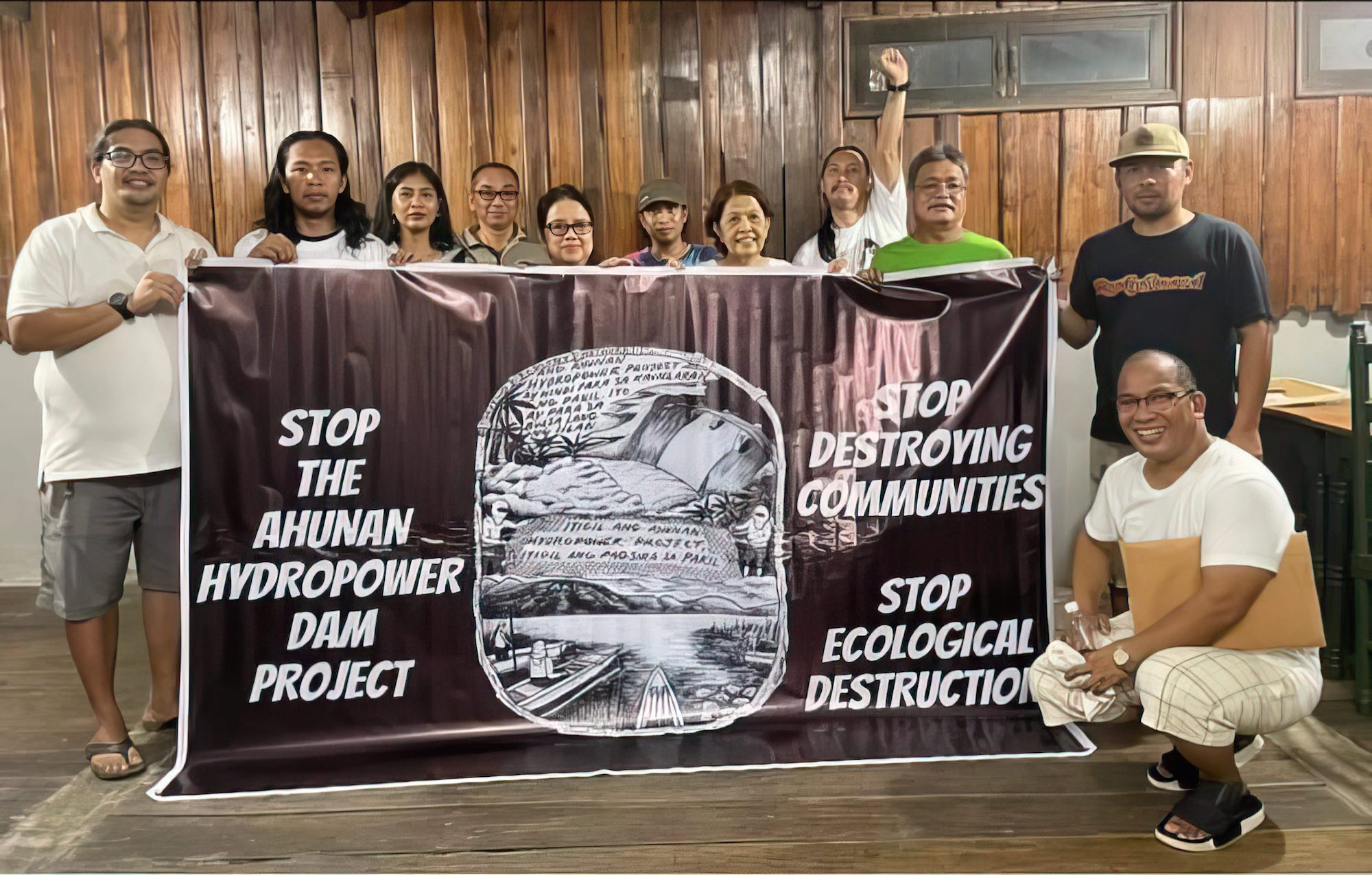


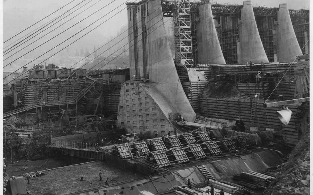
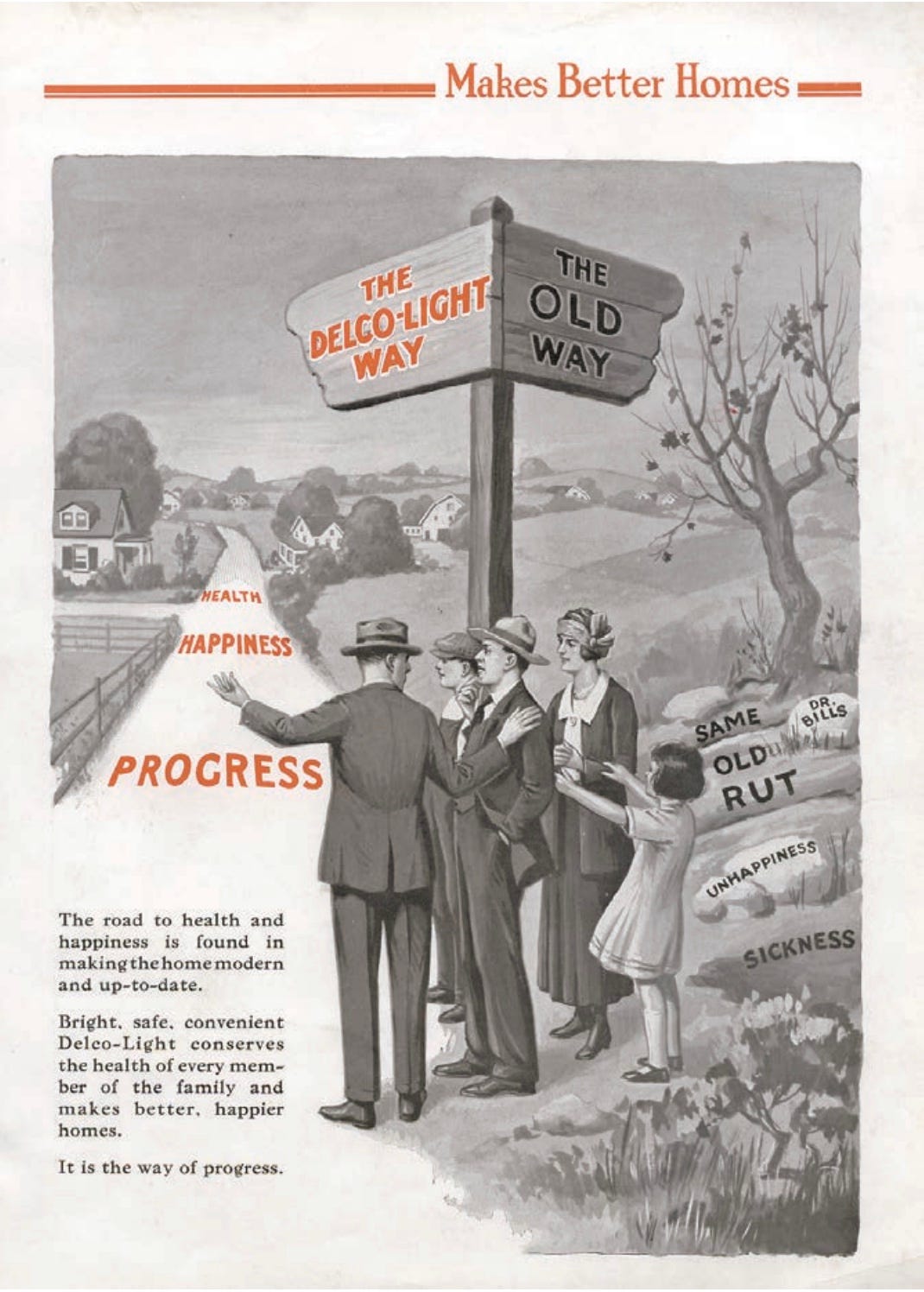

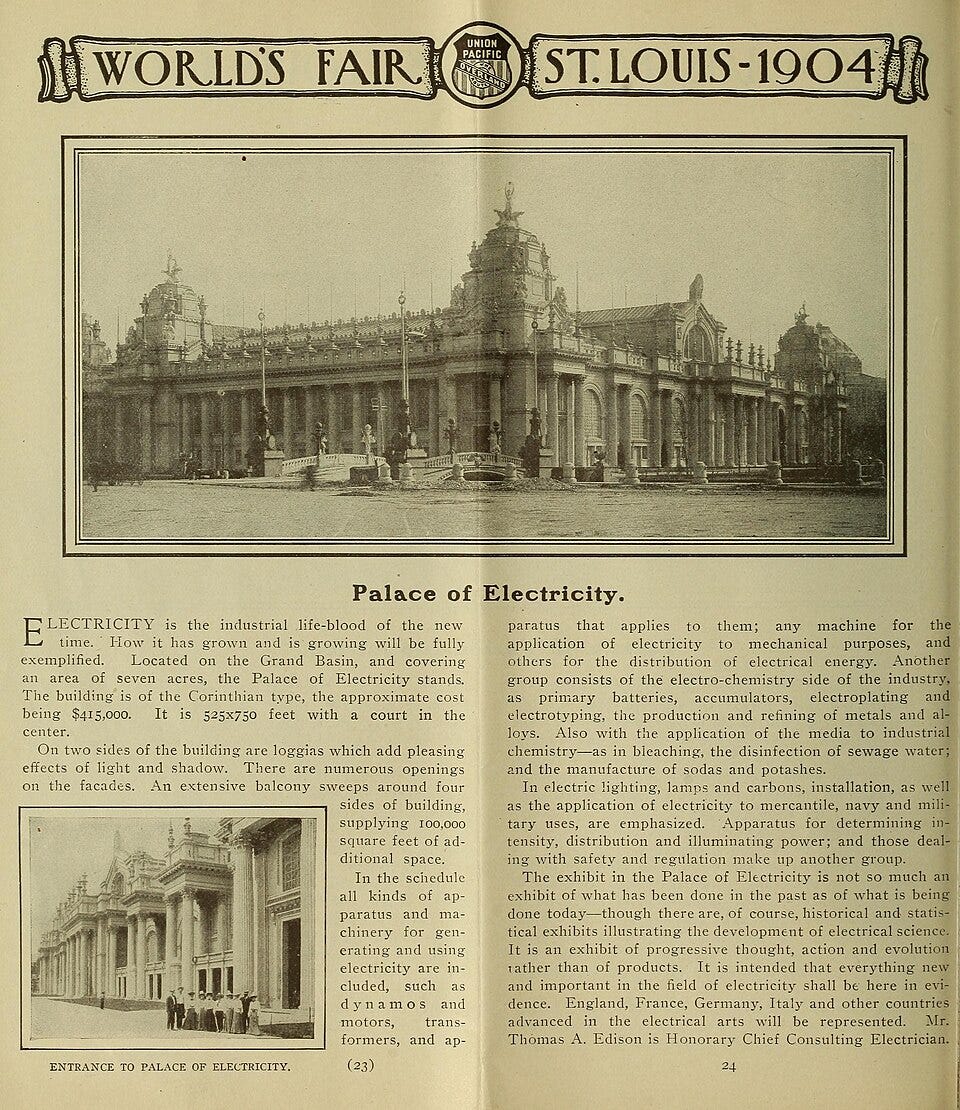


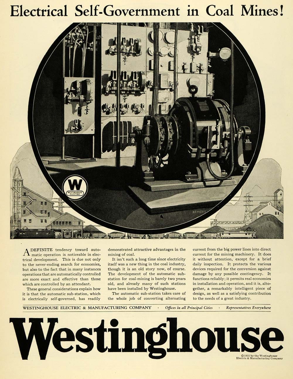
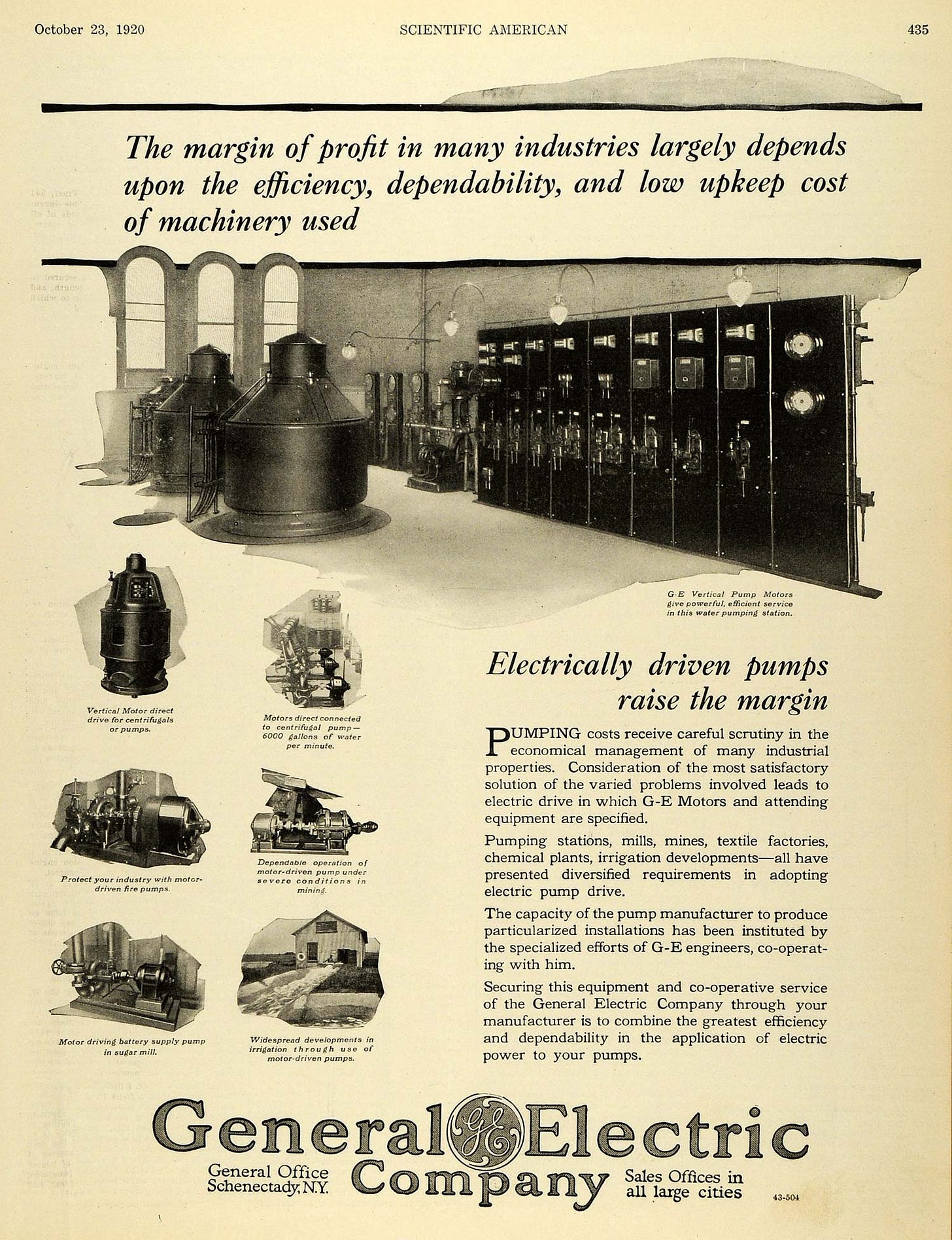
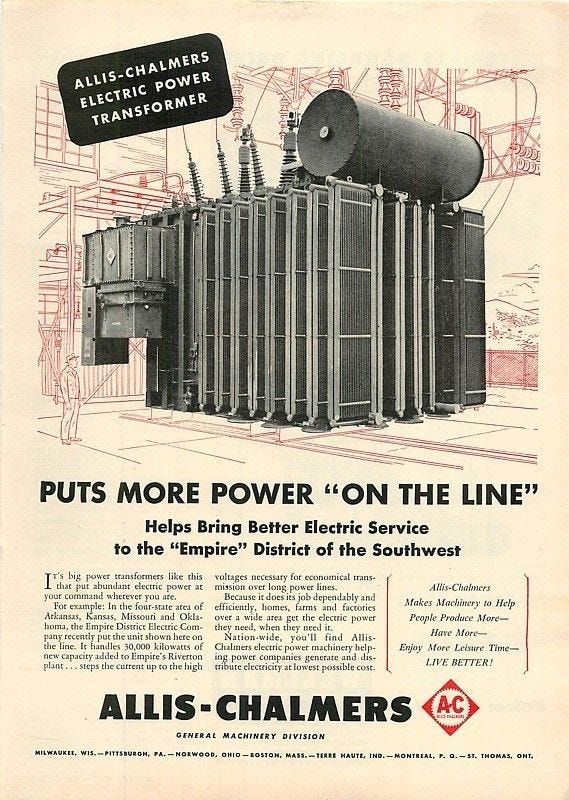
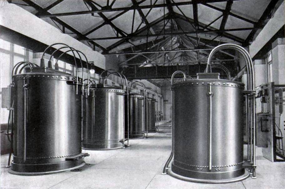


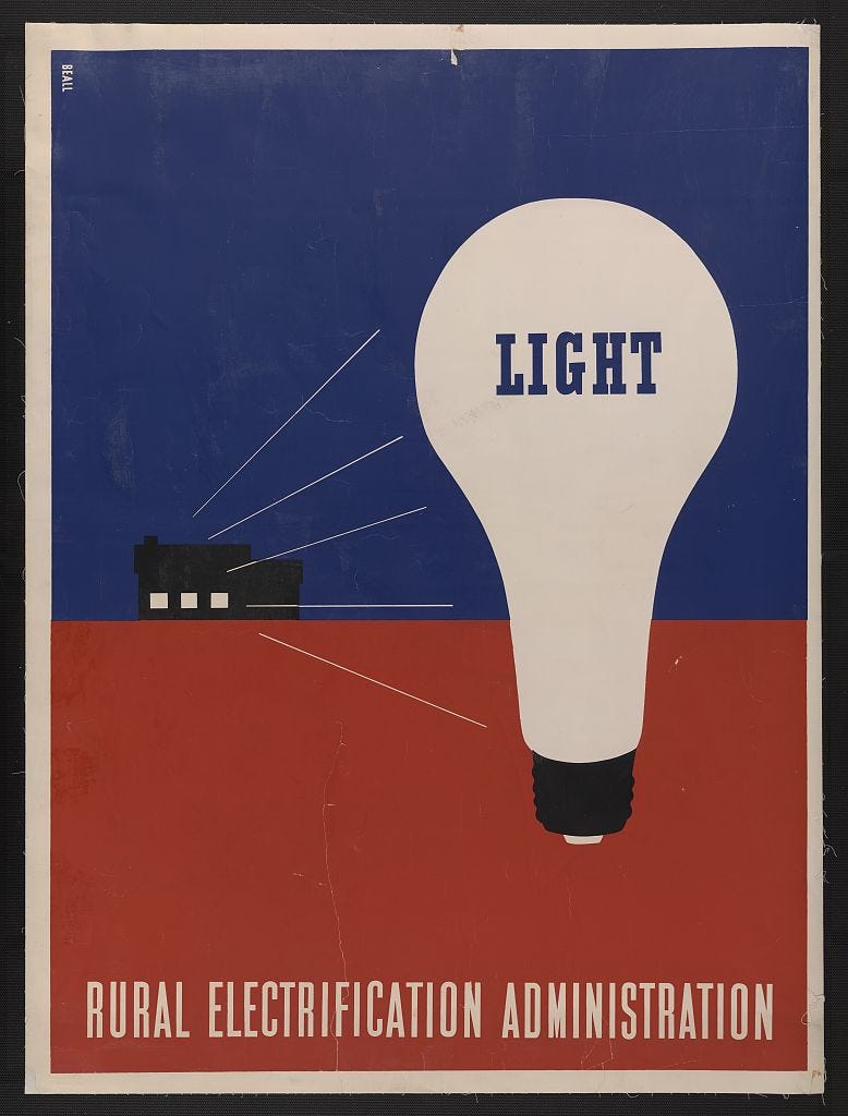
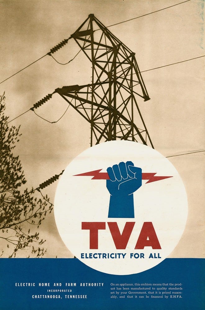


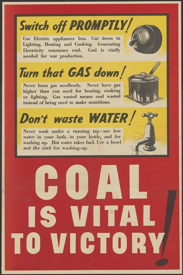
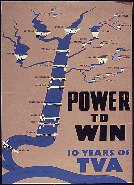
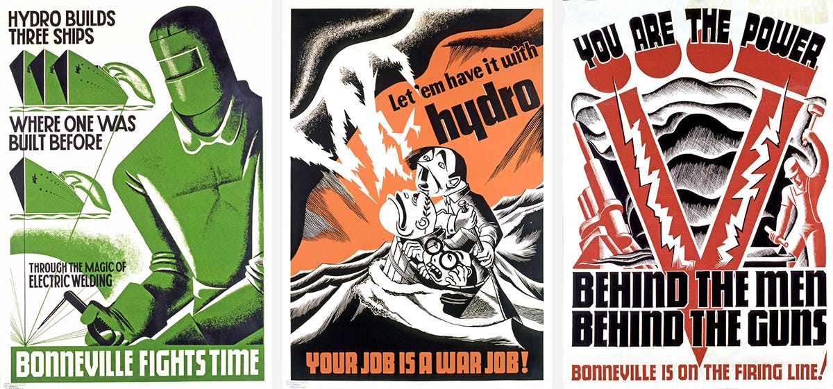
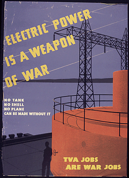


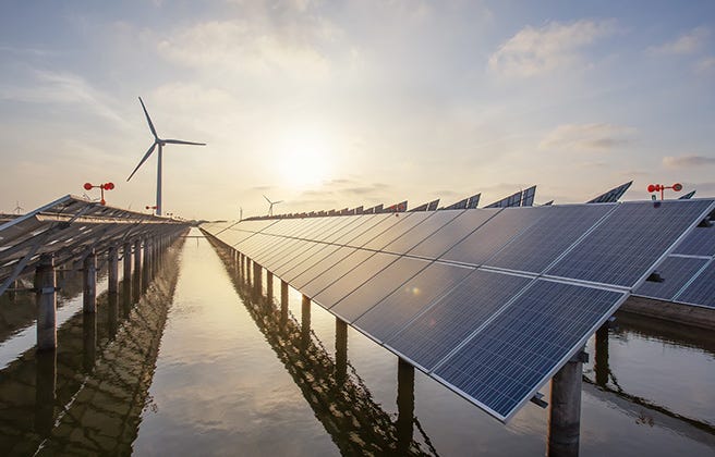

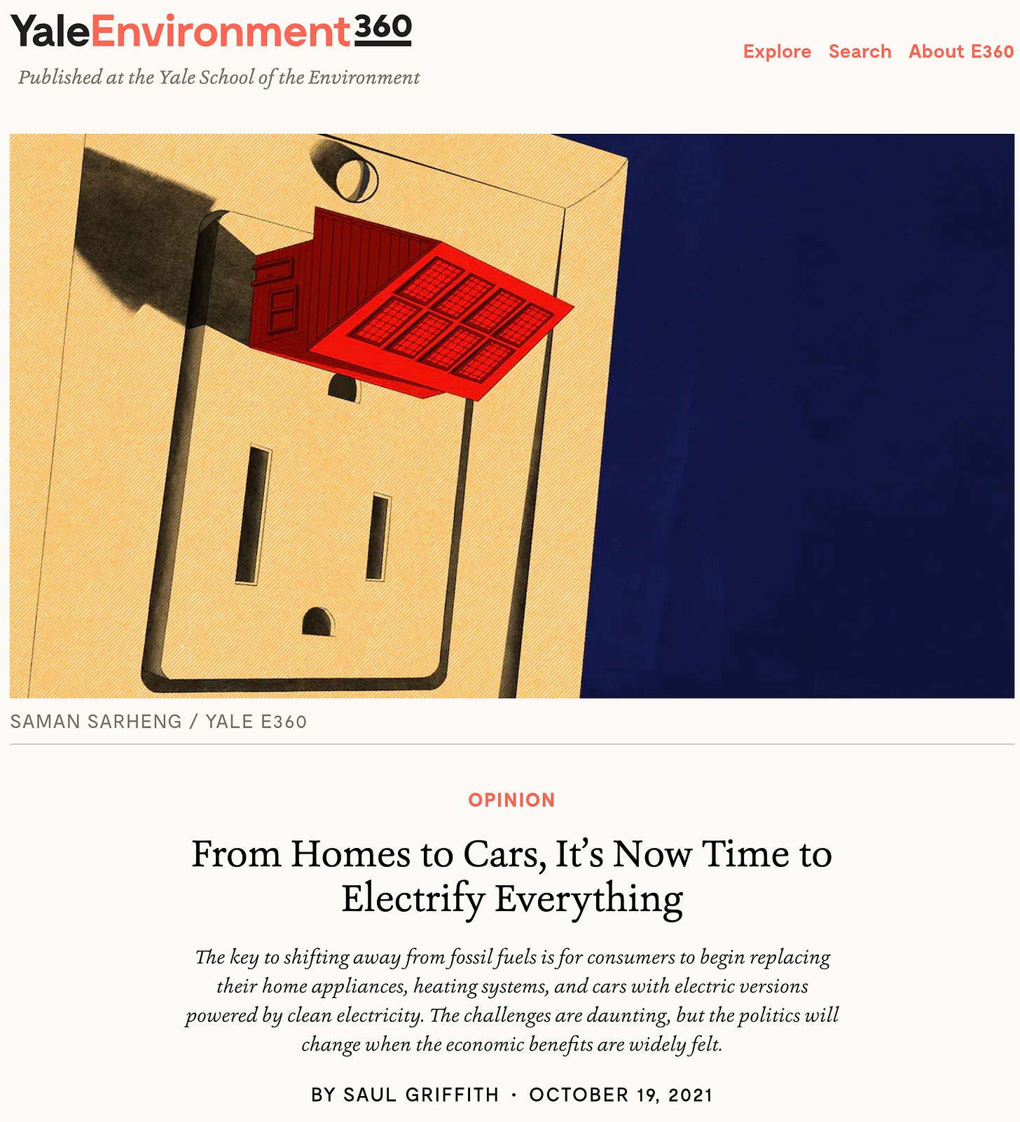


_(14781039084).jpg)