The Rights of Nature movement has arrived in the United States! On September 25, Deep Green Resistance, with noted civil rights attorney Jason Flores-Williams, filed a first-in-the-nation lawsuit – Colorado River v. Colorado – seeking personhood for the Colorado River and recognition of the river’s rights to exist, flourish, regenerate, and naturally evolve in the United States District Court, District of Denver. While courts in India, New Zealand, and Ecuador have granted rights to ecosytems, this lawsuit represents the first Rights of Nature action ever brought before a federal court. If the case succeeds, the natural world will gain a powerful new tool in the struggle to stop corporate exploitation.
We invite everyone who loves the Colorado River and the natural world who gives us life to pack the courthouse with us. We want to send a strong message to the judge, the State of Colorado, and the nation that it’s time the American legal system honor the Rights of Nature. The first hearing in the case has been scheduled for Tuesday, November 14 at 10 AM (mountain):
Magistrate Judge Nina Y. Wang
Byron G. Rogers Courthouse C253
1929 Stout Street
Denver, CO 80294
This moment presents an opportunity to change the future of American environmental law while securing a foothold for the Rights of Nature movement in this country. Please join us in Denver to defend the Colorado River.
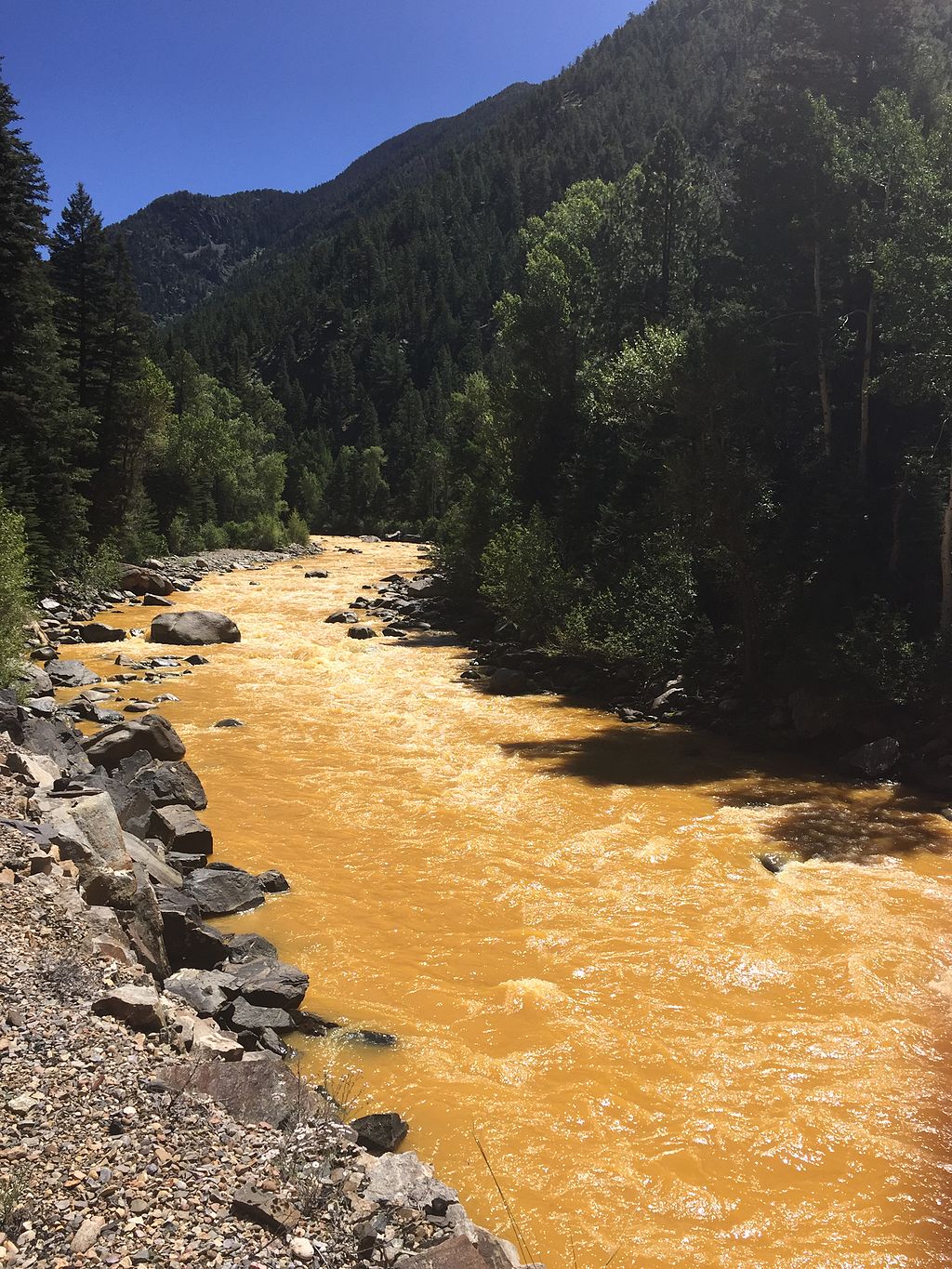
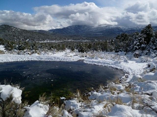
Featured image: The 2015 Gold King Mine waste water spill in the Animas River, in southwest Colorado. The Animas is a tributary to the Colorado River.
Editor’s note: The first Rights of Nature lawsuit in the US was filed on September 25, 2017, in Denver, Colorado. The full text of the complaint can be found here.
“Contemporary public concern for protecting nature’s ecological equilibrium should lead to the conferral of standing upon environmental objects to sue for their own preservation.” Supreme Court Justice William O. Douglas, Sierra Club v. Morton (1972)
Denver, Colorado–In a first-in-the-nation lawsuit filed in federal court, the Colorado River is asking for judicial recognition of itself as a “person,” with rights of its own to exist and flourish. The lawsuit, filed against the Governor of Colorado, seeks a recognition that the State of Colorado can be held liable for violating those rights held by the River.
The Plaintiff in the lawsuit is the Colorado River itself, with the organization Deep Green Resistance – an international organization committed to protecting the planet through direct action – filing as a “next friend” on behalf of the River. The River and the organization are represented in the lawsuit by Jason Flores Williams, a noted civil rights lawyer and lead attorney in a recent class-action case filed on behalf of Denver’s homeless population.
While this is the first action brought in the United States which seeks such recognition for an ecosystem, such actions and laws are becoming more common in other countries. In 2008, the country of Ecuador adopted the world’s first national constitution which recognized rights for ecosystems and nature; over three dozen U.S. municipalities, including the City of Pittsburgh, have adopted similar laws; and courts in India and Colombia have recently recognized that rivers, glaciers, and other ecosystems may be treated as “persons” under those legal systems.
Serving as an advisor to the lawsuit is the Community Environmental Legal Defense Fund (CELDF), a nonprofit public interest law firm which has previously assisted U.S. municipalities and the Ecuadorian government to codify legally enforceable rights for ecosystems and nature into law.
Attorney Flores-Williams explained that “current environmental law is simply incapable of stopping the widescale environmental destruction that we’re experiencing. We’re bringing this lawsuit to even the odds – corporations today claim rights and powers that routinely overwhelm the efforts of people to protect the environment. Our judicial system recognizes corporations as “persons,” so why shouldn’t it recognize the natural systems upon which we all depend as having rights as well? I believe that future generations will look back at this lawsuit as the first wave of a series of efforts to free nature and our communities from a system of law which currently guarantees their destruction.”
Deanna Meyer, a member of Deep Green Resistance and one of the “next friends” in the lawsuit, affirmed Flores-Williams’ sentiments, declaring that “without the recognition that the Colorado River possesses certain rights of its own, it will always be subject to widescale exploitation without any real consequences. I’m proud to stand with the other “next friends” in this lawsuit to enforce and defend the rights of the Colorado, and we’re calling on groups across the country to do the same to protect the last remaining wild places in this country and beyond.”
The lawsuit seeks recognition by the Court that the Colorado River Ecosystem possesses the rights to exist, flourish, regenerate, and restoration, and to recognize that the State of Colorado may be held liable for violating those rights in a future action. The complaint will be filed in the US District Court of Colorado on Tuesday.
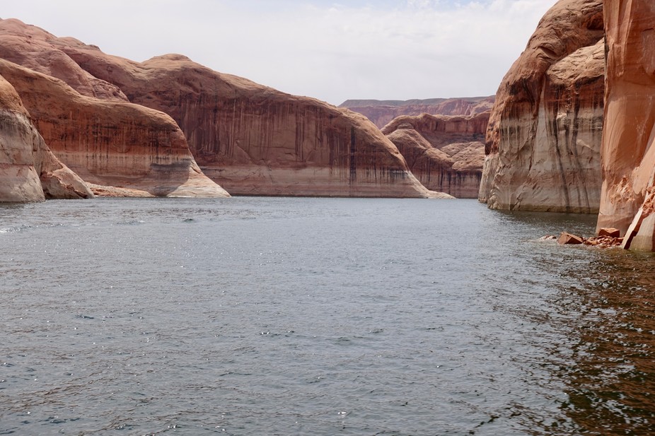
Featured image: Lake Powell, photographed April 12, 2017. The white ‘bathtub ring’ at the cliff base indicates how much higher the lake reached at its peak, nearly 100 feet above the current level. Patti Weeks
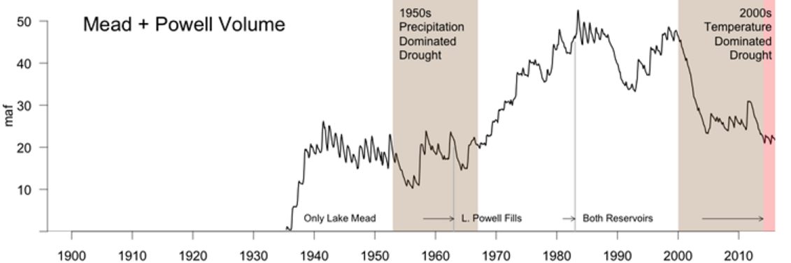
The nation’s two largest reservoirs, Lake Mead on the Arizona/Nevada border and Lake Powell on the Arizona/Utah border, were brim full in the year 2000. Four short years later, they had lost enough water to supply California its legally apportioned share of Colorado River water for more than five years. Now, 17 years later, they still have not recovered.
This ongoing, unprecedented event threatens water supplies to Los Angeles, San Diego, Phoenix, Tucson, Denver, Salt Lake City, Albuquerque and some of the most productive agricultural lands anywhere in the world. It is critical to understand what is causing it so water managers can make realistic water use and conservation plans.
While overuse has played a part, a significant portion of the reservoir decline is due to an ongoing drought, which started in 2000 and has led to substantial reductions in river flows. Most droughts are caused by a lack of precipitation. However, our published research shows that about one-third of the flow decline was likely due to higher temperatures in the Colorado River’s Upper Basin, which result from climate change.
This distinction matters because climate change is causing long-term warming that will continue for centuries. As the current “hot drought” shows, climate change-induced warming has the potential to make all droughts more serious, turning what would have been modest droughts into severe ones, and severe ones into unprecedented ones.
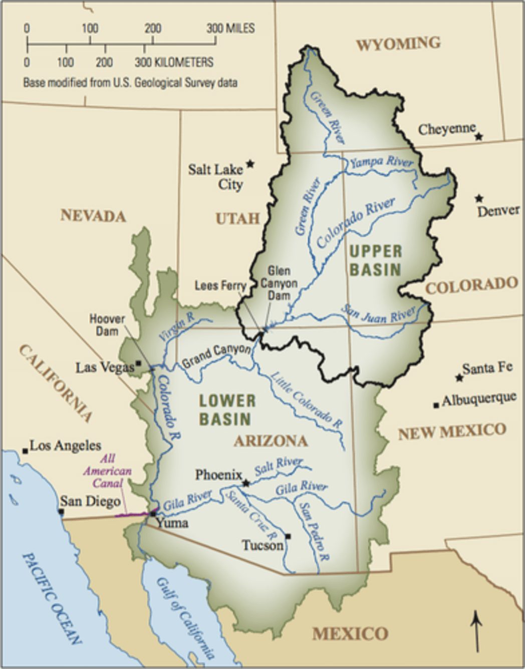
The Colorado River is about 1,400 miles long and flows through seven U.S. states and into Mexico. The Upper Colorado River Basin supplies approximately 90 percent of the water for the entire basin. It originates as rain and snow in the Rocky and Wasatch mountains. USGS
How climate change reduces river flow
In our study, we found the period from 2000 to 2014 is the worst 15-year drought since 1906, when official flow measurements began. During these years, annual flows in the Colorado River averaged 19 percent below the 20th-century average.
During a similar 15-year drought in the 1950s, annual flows declined by 18 percent. But during that drought, the region was drier: rainfall decreased by about 6 percent, compared to 4.5 percent between 2000 and 2014. Why, then, is the recent drought the most severe on record?
The answer is simple: higher temperatures. From 2000 to 2014, temperatures in the Upper Basin, where most of the runoff that feeds the Colorado River is produced, were 1.6 degrees Fahrenheit higher than the 20th-century average. This is why we call this event a hot drought. High temperatures continued in 2015 and 2016, as did less-than-average flows. Runoff in 2017 is expected to be above average, but this will only modestly improve reservoir volumes.
High temperatures affect river levels in many ways. Coupled with earlier snow melt, they lead to a longer growing season, which means more days of water demand from plants. Higher temperatures also increase daily plant water use and evaporation from water bodies and soils. In sum, as it warms, the atmosphere draws more water, up to 4 percent more per degree Fahrenheit from all available sources, so less water flows into the river. These findings also apply to all semi-arid rivers in the American Southwest, especially the Rio Grande.
The combined contents of the nation’s two largest reservoirs, Lake Mead and Lake Powell, since their initial fillings. The large decline since 2000 is shaded brown for 2000-2014, our 15-year study period, and pink for the continuing drought in 2015-2016. The loss was significantly influenced by record-setting temperatures, unlike a similar 15-year drought in the 1950s which was driven by a lack of precipitation. Bradley Udall, Author provided
A hotter, drier future
Knowing the relationship between warming and river flow, we can project how the Colorado will be affected by future climate change. Temperature projections from climate models are robust scientific findings based on well-tested physics. In the Colorado River Basin, temperatures are projected to warm by 5°F, compared to the 20th-century average, by midcentury in scenarios that assume either modest or high greenhouse gas emissions. By the end of this century, the region would be 9.5°F warmer if global greenhouse gas emissions are not reduced.
Using simple but strong relationships derived from hydrology models, which were buttressed by observations, we and our colleagues calculated how river flows are affected by higher temperatures. We found that Colorado River flows decline by about 4 percent per degree Fahrenheit increase, which is roughly the same amount as the increased atmospheric water vapor holding capacity discussed above. Thus, warming could reduce water flow in the Colorado by 20 percent or more below the 20th-century average by midcentury, and by as much as 40 percent by the end of the century. Emission reductions could ease the magnitude of warming by 2100 from 9.5°F to 6.5°F, which would reduce river flow by approximately 25 percent.
Large precipitation increases could counteract the declines that these all-but-certain future temperature increases will cause. But for that to happen, precipitation would have to increase by an average of 8 percent at midcentury and 15 percent by 2100.
The American Canal carries water from the Colorado River to farms in California’s Imperial Valley. Adam Dubrowa, FEMA/Wikipedia
On a year-in, year-out basis, these large increases would be substantial. The largest decade-long increases in precipitation in the 20th century were 8 percent. When such an increase occurred over 10 years in the Colorado Basin in the 1980s, it caused large-scale flooding that threatened the structural stability of Glen Canyon Dam, due to a spillway failure not unlike the recent collapse at California’s Oroville Dam.
For several reasons, we think these large precipitation increases will not occur. The Colorado River Basin and other areas around the globe at essentially the same latitudes, such as the Mediterranean region and areas of Chile, South Africa and Australia, are especially at risk for drying because they lie immediately poleward of the planet’s major deserts. These deserts are projected to stretch polewards as the climate warms. In the Colorado River basin, dry areas to the south are expected to encroach on some of the basin’s most productive snow and runoff areas.
Moreover, climate models do not agree on whether future precipitation in the Colorado Basin will increase or decrease, let alone by how much. Rain gauge measurements indicate that there has not been any significant long-term change in precipitation in the Upper Basin of the Colorado since 1896, which makes substantial increases in the future even more doubtful.
Megadroughts, which last anywhere from 20 to 50 years or more, provide yet another reason to avoid putting too much faith in precipitation increases. We know from tree-ring studies going back to A.D. 800 that megadroughts have occurred previously in the basin.
March of 2017 was the warmest March in Colorado history, with temperatures a stunning 8.8°F above normal. Snowpack and expected runoff declined substantially in the face of this record warmth. Clearly, climate change in the Colorado River Basin is here, it is serious and it requires multiple responses.
It takes years to implement new water agreements, so states, cities and major water users should start to plan now for significant temperature-induced flow declines. With the Southwest’s ample renewable energy resources and low costs for producing solar power, we can also lead the way in reducing greenhouse gas emissions, inducing other regions to do the same. Failing to act on climate change means accepting the very high risk that the Colorado River Basin will continue to dry up into the future.
The Great Basin stretches from Utah’s Great Salt Lake to the Sierra Nevada Mountains and from southern Idaho to southern California. About seven inches of rain falls in Nevada a year, and some areas receive less than five. The Great Basin is a cold desert, and in eastern Nevada and western Utah, it has been getting drier for a decade. [1]
The Southern Nevada Water Authority (SNWA), the water agency for Las Vegas, Henderson, and North Las Vegas, proposes pumping up to 200,000 acre-feet annually from eastern to southern Nevada through 300 miles of pipeline. An acre-foot is enough water to cover an acre of land a foot deep, or about 325,850 US gallons. Cost estimates vary from $3.5 billion (what SNWA tells the public) to $15 billion dollars (what SNWA was required by law to tell the State Engineer). This project is seen as a threat by several Indian tribes and rural communities, and is expected to do immense damage to many rare endemic species, desert vegetation, and the land itself, much of which is open range. [2]
Basin and Range
Life in the Great Basin’s valleys, human and otherwise, depends on shallow groundwater, springs, and creeks, which in turn depend on groundwater flows from rain and snow in mountain ranges. 200,000 acre-feet is about 65 billion gallons of water, equivalent to the average flow of Nevada’s Humboldt River. SNWA claims that it can pump this water from the Spring, Delamar, Dry Lake, and Cave Valleys without harm; though it’s clear to those who live in the Great Basin that if most of the water flowing in from the mountains is drawn away, eventually most everything in the valleys will die.
The Bureau of Land Management’s final decision on the right-of-way for the project [3] allows for the pumping of 150,000 annual acre-feet. [4] A drawdown projection commissioned by the Goshute Tribe [5] (and other analyses) reflect a far more destructive outcome than the SNWA claims. Access to Snake Valley (much of which is in Utah) groundwater is still in dispute, but the US Geological Survey has concluded the multiple valleys’ aquifers are connected, so it’s likely that Utah’s groundwater would be impacted anyway. [6]
According to the Great Basin Water Network, “Independent hydrologists dispute it is possible to pump and export so much water without causing major environmental degradation and destroying the livelihoods of rural residents in eastern Nevada and western Utah. The area targeted for the massive pumping proposal is home to National Wildlife Refuges… Great Basin National Park is surrounded by the proposed groundwater pump and export project. The proposed pumping scheme would bring two hundred or more wells with power lines, roads, and linked buried pipelines to cover the valleys on both sides of the National Park—some right on the border of the park.
Communities like Baker, Nevada on the Utah border would have large production wells in their backyard sending local water to a city 300 miles away.” [7] As pipeline foe Rick Spilsbury puts it, “This would mean the end of any economic development anywhere near the drained areas. The likely result would be a mass emigration and the eventual transformation of the area into a national toxic dump site.” Impacts to land, water, and air could extend as far as Salt Lake City and its surrounding urban areas (which already have some of the worst air pollution in the US). Physicians for Social Responsibility predicts a dewatered basin-and-range country could increase downwind particulate pollution from dust storms, including the toxic mineral erionite. [8] In textbook fashion, the city of Las Vegas is exporting suffering and violence to import resources that it cannot acquire in its immediate landbase.
Overdrawn River
Author Marc Reisner wrote, “To some conservationists the Colorado River is the preeminent symbol of everything mankind has done wrong—a harbinger of a squalid and deserved fate. To its preeminent impounder, the US Bureau of Reclamation, it is the perfection of an ideal.” [9] In 2013, American Rivers announced the Colorado as the US’s most endangered river, and that “over-allocation and drought have placed significant stress on water supplies, river health, and fish and wildlife. To underscore the immediacy of the problem, the basin is facing another drought this summer. The Bureau of Reclamation’s report released in December stresses that there is not enough water to meet current demands across the basin, let alone support future demand increases.” [10]
Under the interstate Colorado River Compact of 1922, the entire state of Nevada was allowed 300,000 acre feet per year (AFY) of Colorado River water. One AFY is approximately 3380 liters per day, “the planned water usage of a suburban family household, annually. In some areas of the desert Southwest, where water conservation is followed and often enforced, a typical family uses only about 0.25 [AFY].” [11] The Imperial Irrigation District, whose water rights predate the 1922 Compact, owns approximately three million acre feet (MAF) per year, and the entire city of Los Angeles uses about one MAF per year. Though laws controlling the use of water are typically state, not federal, and vary widely from state to state (in Arizona, for instance, there is little legally recognized relationship between ground and surface water), the 1922 Compact is a binding agreement between states. The Upper Basin must deliver a total of 7.5 MAF per year to the Lower Basin (the dividing line is at Lee’s Ferry in Glen Canyon, in Utah), and the US must deliver one MAF a year to Mexico. [12] Across the entire Colorado River basin, nearly all climate models predict an increase in both aridity and flooding. [13]
As increasing temperatures force the jet stream further north and more water evaporate from soil and reservoirs like Lake Powell (where an average 860,000 acre-feet of water—about 8 percent of the Colorado River’s annual flow—is lost every year) [14], overall water availability will decrease even if summer storms and spring runoff paradoxically become more intense. 2012 was the first recorded year the Colorado River flow peaked in April. [15] Though the water level in Lake Mead (where Las Vegas siphons its water from) has priority over Lake Powell’s (upstream), Las Vegas has little water from the river’s apportionment overall because in 1922, when the Compact was made, there were very few people in Nevada and no guess at what Las Vegas might become.
Southern Nevada at one point had the highest growth rate in the US, but following the economic recession Nevada had the highest national rate of foreclosures, bankruptcies, and unemployment. In 2010, there were 167,564 empty houses in Nevada—one in seven. In Las Vegas, residential property prices have fallen by 50 percent on average from 2008 to 2011, when Nevada homes changed hands for an average of $115,000. [16] As one SNWA pipeline opponent remarked, “My house in Las Vegas dropped from $307,500 to be foreclosed, and then resold at $190,000.”
When the SNWA groundwater pipeline was first conceived, the water agency was planning for growth on a much higher trajectory, and this momentum has carried through the recession to the present day. So while southern Nevada’s water future in general is threatened by drought and Nevada’s small original apportionment, the groundwater pipeline is driven by hopes for future growth, not immediate need. [16]
Indigenous Human Rights
The Confederated Tribes of the Goshute, or CTGR (the name “Goshute” derives from the native word Ku’tsip or Gu’tsip, people of ashes, desert, or dry earth), [17] “reside in an isolated oasis in the foothills of the majestic Deep Creek Mountains on what is now the Utah/ Nevada state line,” according to their web page Protect Goshute Water. There are 539 enrolled tribal members, and about 200 of them live in Deep Creek Valley. “Our reservation lies in one of the most sparsely populated regions of the United States, and it has always been our home. Resulting from this isolation, we have benefited by retaining strong cultural ties to Goshute land, our traditions, and a resolute determination to protect our ways.
Ironically, water, the most elemental resource in our basin, is the very thing developers now seek to extract and send 300 miles away for Las Vegas suburbs. The Southern Nevada Water Authority’s pipeline proposal would draw 150,000 acre feet per year from the Great Salt Lake Watershed Basin lowering the water table, drying up our springs, and fundamentally changing access to water over this vast region for plants, wildlife, and people.” They go on to say that “SNWA’s groundwater development application is the biggest threat to the Goshute way of life since European settlers first arrived on Goshute lands more than 150 years ago.” [18]
In Spring Valley in eastern Nevada, a narrow band of swamp cedar trees mark the site of 1863 and 1897 US military massacres of Goshute and Shoshone peoples, and here is where the Goshute and Duckwater and Ely Shoshone tribes grieve and hold spiritual ceremonies. Goshute tribal chairman Ed Naranjo says that “Swamp Cedars is important to many tribes, certainly to CTGR, Ely, and Duckwater, but also to many Paiute, Shoshone, and Ute Tribes.” The Swamp Cedars Massacre is relatively obscure, compared to well-known massacres at Bear River [19] and Wounded Knee.
Goshute elders believe that murder victims physically and spiritually fed the swamp-cedar trees; according to former Goshute council chairman Rupert Steele, “Otherwise you’d never see swamp cedar grow this tall and strong.” In a 2011 Nevada State Engineer hearing, an SNWA attorney likened the Goshute beliefs to children fearing the bogeyman. The Spring Valley swamp cedar grove is one of many sites that could be drained by the SNWA pipeline. [20] A “Cultural Property and Cultural Landscape” report on Spring Valley, Nevada, prepared by an independent ethnographer for Goshute and Ely and Duckwater Shoshone tribes was ignored by the BLM in their environmental analysis. [21]
Rick Spilsbury, a Shoshone Indian, says that “As far as the Native Americans of Nevada and Utah are concerned, this is just a continuation of the land and resource grab that has existed since the authoring of the Bill of Rights. Those who take have been writing the rules. The Colorado River Compact was organized specifically to exclude Native Americans and Mexicans from having any water rights. And the omission of Federal water protections for Native Americans from State water affairs was obviously not an oversight, or it would have been fixed by now. Native Americans don’t have the legal ability to stop their exploitation. [22]
“The Western Shoshone still hunt and gather here—right where the worst of the environmental damage will be. The mass killing of life in this area will not only be the final blow to Western Shoshone culture, it will be a serious threat to their long-term sustainability—and even viability. Water is life. And SNWA intends to take it.”
Opposition
Not surprisingly, a water appropriation on this scale has been hard fought by those whose livelihoods will be affected, as well as indigenous communities and environmental groups. Even within southern Nevada there’s some rate-payer opposition [23]—the project’s costs will be added to water bills—and Utah’s governor Gary Herbert recently rejected a proposed agreement with the SNWA for Snake Valley groundwater. [24] Litigation on various aspects of this project may well proceed to the US Supreme Court.
(Though Herbert’s decision was widely praised by both West Desert ranchers and environmentalists, not everyone in Utah concurred. Ron Thompson, of the Washington County, Utah, Water Conservancy District, criticized the move as “hypocritical for us to tell Nevada not to develop a water project. Ultimately they will figure out how to do it.” [25] Washington County wants to build its own expensive water pipeline from Lake Powell to the St. George area, and Thompson thinks Governor Herbert is sacrificing a “positive tradition of bi-state cooperation” in turning the SNWA down. A Lake Powell pipeline opponent observed that “It’s imperative that opposition to both projects stays active and coordinated.” [26])
Deep Green Resistance’s Southwest Coalition proposes this strategy:
Though we’re too recently involved to have any legal standing, our emphasis on indigenous solidarity has drawn us to ally ourselves with the affected indigenous groups. Though their governments haven’t agreed to any formal affiliation, we offer them support through:
1. Organizing opposition in communities outside the reservations.
2. Fundraising for efforts to fight the pipeline, whatever that might be. Donations are tax-deductible and can be made by PayPal to deepgreenfertileground@gmail.com. Please put “SNWA” in the comments section. The Great Basin Water Network also accepts donations, at or Great Basin Water Network, P O Box 75, Baker, NV 89311 (Nevada non-profit #35-2278153).
3. Influencing public opinion and promoting taxpayer opposition to the pipeline.
4. Sponsoring educational events and outreach. This might include inviting indigenous people (and supporting travel costs) to events we can organize in Salt Lake City and Las Vegas to speak against the pipeline.
5. Organizing protests and rallies. We can help redefine this issue as one of human rights violation, not only environmental destruction.
6. Encouraging negative press coverage of the SNWA and pipeline proposal. Encouraging positive press coverage of the Great Basin’s unique beauty, and the long indigenous people’s relationship with it.
7. Discouraging project investors/lenders.
8. We can also organize and train for nonviolent civil disobedience to fight the pipeline construction, should legal or administrative efforts fail. This is a tactical tool that’s aimed at physically stopping construction. It’s not symbolic, it’s strategic; there are ways of minimizing the expense and suffering to activists and maximizing expense and delay of the enemy, and we feel it’s best to plan for the unfortunate possibility that this struggle may well arrive at this point. We believe it’s our responsibility as privileged members of the dominant culture to put our bodies between the bulldozers and indigenous peoples and lands.
[1] “Great Basin Water Issues,” Great Basin Water Network, accessed December 26, 2012, http://www.greatbasinwater.net/issues/index.php This page offers a good overview of Great Basin water issues, including the SNWA proposed pipeline.
See the U.S. Drought Monitor for current data: The U.S. Drought Monitor. National Drought Mitigation Center at the University of Nebraska-Lincoln, United States Department of Agriculture, National Oceanic and Atmospheric Administration. http://droughtmonitor.unl.edu/
[2] The U.S. Drought Monitor. National Drought Mitigation Center at the University of Nebraska-Lincoln, United States Department of Agriculture, National Oceanic and Atmospheric Administration. http://droughtmonitor.unl.edu/
[4] “SNWA appears as if it’s planning on Snake Valley water, said Rob Mrowka of the Tucson-based Center for Biological Diversity.
Despite the fact that the Nevada engineer approved water rights of 84,000 acre feet, he said, the BLM is set to approve a pipeline capable of carrying 117,000 acre feet.” Christopher Smart, “BLM poised to OK Las Vegas plan to pump and pipe desert groundwater,” Salt Lake Tribune, August 6, 2012, http://www.sltrib.com/sltrib/politics/54624691-90/blm–eis–final–las.html.csp
[6] “While the BLM’s final EIS spares Snake Valley along the Utah-Nevada border from groundwater pumping, critics say drilling in nearby valleys will draw down the aquifer beneath Snake Valley,” “Goshutes blast BLM study on Las Vegas water pipeline,” Las Vegas Review-Journal, August 5, 2012, http://www.lvrj.com/news/goshutes–blast–blm–study–on–las–vegas–water–pipeline-165082706.html
[8]“Dr. Jeff Patterson, president of PSR [Physicians for Social Responsibility], said Westerners should be worried because there is no evidence of any serious attempt to determine if erionite exists in the same areas that would be ‘de-watered by the proposed Las Vegas pipeline and would be kicked up in the particulate pollution. Erionite can cause serious lung disease and a highly lethal cancer called mesothelioma,’” Brian Moench, “No end to Nevada’s quest for water,” Salt Lake Tribune, April 6, 2013, http://www.sltrib.com/sltrib/opinion/56107724-82/utah–nevada–erionite–las.html.csp
[10] Amy Souers Kober, “Announcing America’s Most Endangered Rivers of 2013,” American Rivers, April 17, 2013, https://web.archive.org/web/20130531040706/http://www.americanrivers.org/newsroom/blog/akober-20130417-announcing-americas-most-endangered-rivers-2013.html
[12] The Colorado River is managed and operated under numerous compacts, federal laws, court decisions and decrees, contracts, and regulatory guidelines collectively known as ‘The Law of the River,’” “Colorado River Compact,” Wikipedia, accessed May 14, 2013, http://en.wikipedia.org/wiki/Colorado_River_Compact
[21] Sylvester L. Lahren, Jr. Ph.D., “A Shoshone/Goshute Traditional Cultural Property and Cultural Landscape, Spring Valley, Nevada. Confidential and Proprietary Report for the Goshute Tribal Council,” Confederated Tribes of the Goshute Reservation, August 9, 2010.