Deep Green Resistance aims to amplify the voices of marginalised people, stand in solidarity with the natural world and support direct action that protects our ecosystems.
News Alert
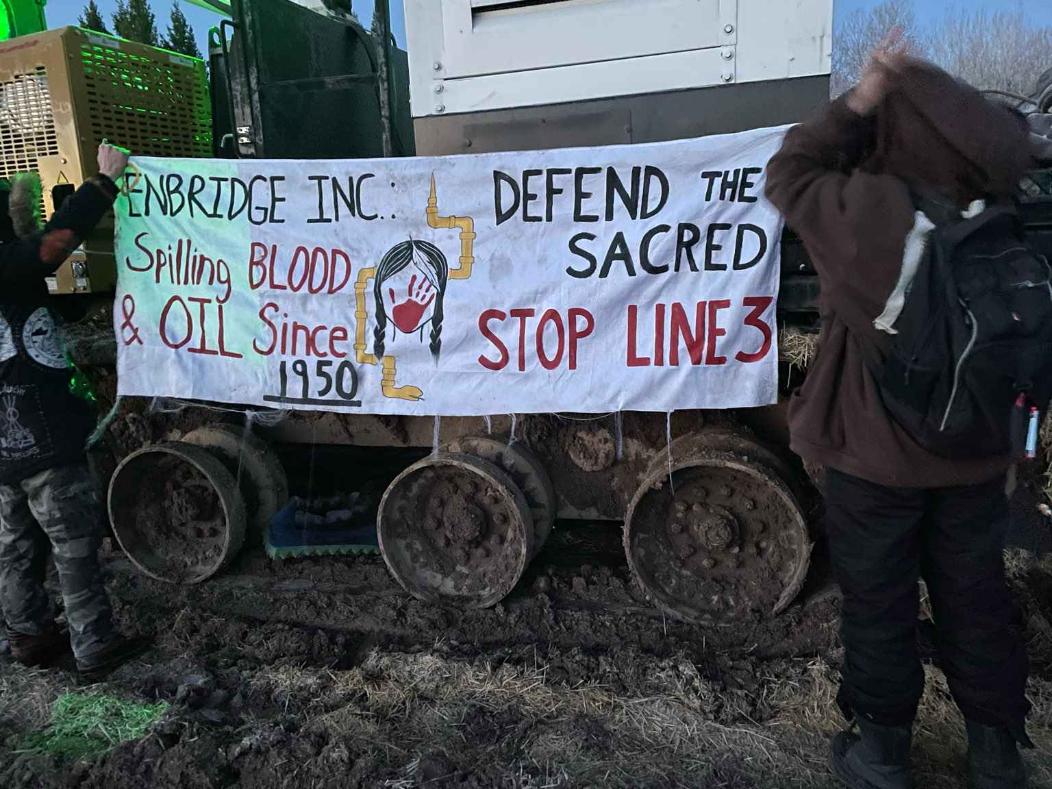
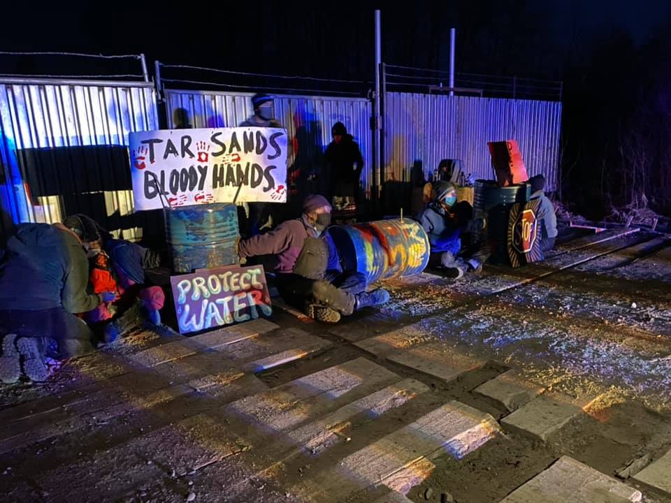
Two actions are taking place on the front lines of the Line 3 resistance movement today. Both Camp Migizi and the Giniw Collective are shutting construction down!
(Swatara, MN) Thursday morning, 7 water protectors locked to each other, blocking work on an Enbridge Line 3 pump station.
Enbridge announced it will be ceasing work in sensitive wetland areas per Minnesota law, but will continue work on pump stations and sites in “non-sensitive areas”. A steady stream of water protectors committed to stand with Anishinaabe treaty territory and future generations grows.
The action follows a visit to the Line 3 resistance by Oscar-winning actress Jane Fonda, who is helping to bring the Ojibwe-led struggle into the national spotlight and reach the Biden administration. It is also the week of Representative Deb Haaland’s confirmation as the first Native cabinet member in U.S. history.
As the spring thaw comes to northern Minnesota, the trees are running with maple sap and many Ojibwe have begun the boil for syrup.
Water is life, and it takes many forms. It is on us to protect our Mother.
Water protector Dakota McKnight said,
“Today I am participating in direct action to against the Line 3 pipeline. I am a student at Macalester College, which is shamefully invested in Enbridge. As person who is of settler descent, I stand in solidarity with the Indigenous people who been fighting colonialism since the Inception of America.”
A Water Protector named “Quintin” said,
“I am here to take action in solidarity with Natives who are fighting this pipeline that is desecrating the land. When institutions fail us, direct action is one of the last mechanisms that hold our power.”
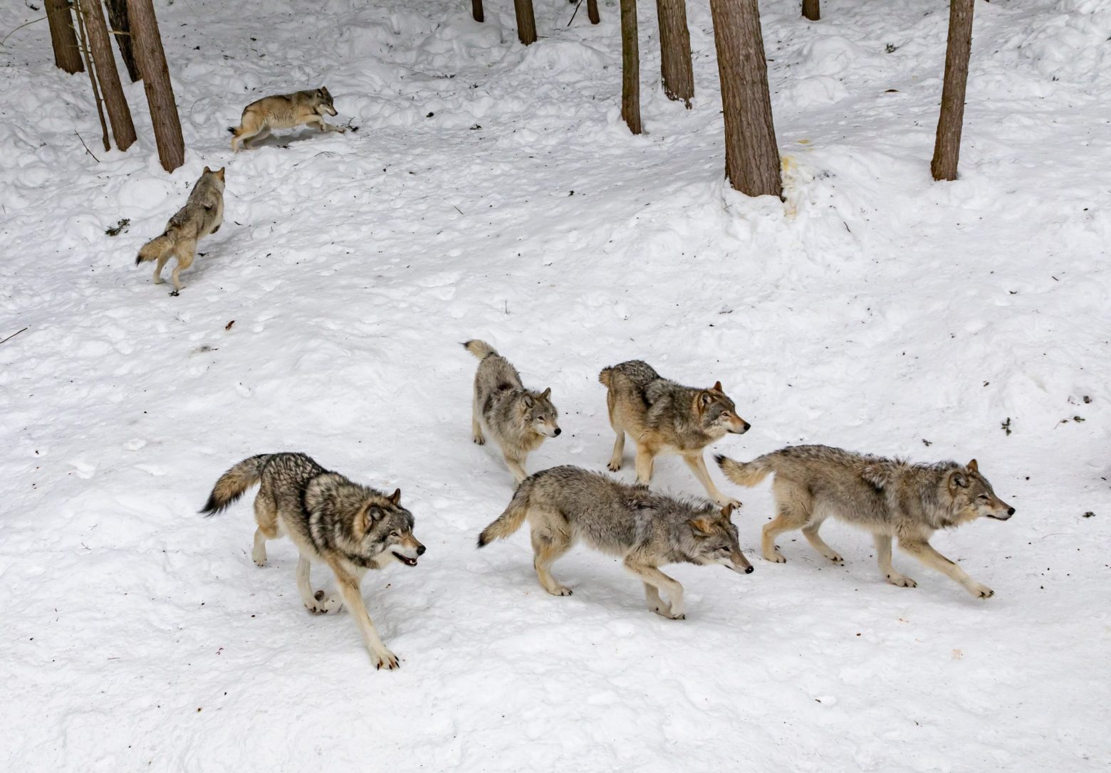
It had seemed for the past half century that perhaps the worst of wolf killing was finally over. After centuries of methodic extermination had nearly completely wiped the animals out of the lower forty-eight, government agencies, scientists, and the general public began to see wolves not primarily as threats to private property, but rather, as invaluable ecological assets that stabilized the ecosystems relied upon by many in the West.
In 1974, the gray wolf was one of the first imperiled species to receive federal protections under the newly-passed Endangered Species Act, As wolves were subsequently reintroduced in Yellowstone National Park and central Idaho in the mid 1990s, and thus began migrating to regain their historic range, they slowly began to recover.
A series of recent events across the country make clear this work of wolf recovery has never been in greater jeopardy.
In January, the Trump administration finalized the removal of gray wolves from the list of animals protected under the Endangered Species Act and, within a matter of weeks, we witnessed a disturbing new chapter in the nation’s history of needless and irresponsible wolf killing.
In Wisconsin, just two weeks ago, over 27,000 people applied for an ill-conceived hunt during the wolves’ mating season that, in only three days, left 216 gray wolves dead. Shocked state officials had to call off the hunt prematurely, but not before the three-day slaughter led to 82 percent more wolf deaths than the state had allocated for the entire hunting and trapping season.
Meanwhile, in Montana, a state in which wolves lost Endangered Species Act protections in 2011, not by the U.S. Fish and Wildlife Service (the “Service), but by a political act of Congress, the federal delisting emboldened the state to up its efforts to eliminate wolves from the landscape. In the past month, the Montana Senate passed a bill allowing for private bounties for dead wolves and the Montana House passed a bill expanding hunting and trapping seasons (and allowing snares) in an effort to further reduce wolf populations. The traps and snares, which often prolong an animal’s death, are indiscriminate and dangerous not only to wolves but also to non-target species. In a recent six-year period in Montana, for example, at least 350 non-target animals, ranging from mountain lions to pet dogs, were caught in traps. Montana’s recent laws to incentivize and further enable wolf hunting are not simply inhumane, they severely threaten to undo gray wolf recovery efforts and destabilize ecosystems.
These recent activities follow on the heels of a similarly unsettling example of failed state-level wolf management in Idaho, where wolves have also been delisted since 2011. There, over a recent twelve-month period, trappers, hunters, and state and federal agencies killed an astounding 570 wolves, including at least thirty-five wolf pups as young as four weeks old. These wolves, some of whom died of hypothermia in traps or were gunned down from helicopters, represented nearly sixty percent of the total estimated wolf population in the state at the end of 2019. This high number of wolf kills directly reflect the state’s wolf policies: Idaho recently increased the legal limit of wolves an individual can kill in a year to thirty, and the Idaho Department of Fish and Game currently funds wolf bounty programs in the state.
Taken together, the examples of Idaho, Wisconsin, and Montana give us all the evidence we need that state-led management does not ensure the protection and recovery of gray wolves.
This horrifying slaughter of wolves in just a few states—based not on science, but on fear and hatred for a long persecuted species—is why WildEarth Guardians has joined a broad coalition of groups across the country to challenge the Service’s decision to delist wolves in court. Wolves have not recovered in the West and the decision to delist them goes against the intent of the Endangered Species Act, which not only mandates the federal government to forestall the extermination of gray wolves but also, crucially, to promote their full recovery. Although this law has played an enormous role in preventing the wholesale loss of gray wolves in the contiguous US, its work to ensure their continued survival and recovery, as these recent examples in Montana, Idaho, and Wisconsin make all too clear, is far from finished.
To let the work of gray wolf recovery go unfinished would be a tragedy hard to tabulate. Gray wolves are a keystone species that play a critical role in the ecological health of their historic range. Being listed under the Endangered Species Act has allowed gray wolves to begin to rebound in the upper Great Lakes region, yet their recovery there does nothing for the populations of gray wolves throughout the West, where the animals remain largely absent or underpopulated in their historic range. For example, in Oregon and Washington, estimates indicate less than 150 wolves in each state while in Colorado, a location in which wolves roamed across all landscapes in the 1800s through early 1900s, has only reported sightings of a handful of lone wolves in the last two years.
The example of success in the upper Great Lakes region should not be used to dismantle wolf protections, but rather, to illustrate the continued need for those protections throughout the country where wolf populations remain extremely vulnerable. Only ongoing federal protections, based on scientific data, will guarantee gray wolves a continued and healthy future in this country. To that end, please urge the Biden administration to restore Endangered Species Act protections for gray wolves.
As our nation reckons with its story of conquest, recent killing sprees of gray wolves in the remote forests of Wisconsin or the northern Rockies should not go unnoticed.
The brutal and bloody history of gray wolves—along with other native megafauna such as bison—in our country is inextricably tied to the larger history of colonization and violence that continues to shape our society. Our country has a deep history of White settlers demonizing the animals in folklore and frontier mythology and equating Native Americans to wolves and other animals within the broader project of colonization. Seen in this light, recent wolf hunts such as what we recently witnessed in Wisconsin are not merely mismanaged debacles, they are part of a much deeper, far more tragic, story.
“Wolves symbolized the frustrations and anxieties of colonization,” as historian Jon T. Coleman has written regarding wolf history in this country, “and the canines paid in blood for their utility as metaphor.”
As we are painfully aware, the history of colonization, and of White frustrations and anxieties surrounding colonization, is ongoing. Gray wolves, sadly, may continue to be part of the story. But gray wolves, and the unsound policies and unethical practices aimed at killing them, also present a way to dive deeper into the nation’s history of colonization and violence in search of ways to reconsider a better future. Wolves are “living reminders of colonization,” in Coleman’s words, that “embody an unbroken history of conquest worth pondering and protecting.” As the nation grapples with its history, protecting the gray wolf is not simply about ensuring healthy ecosystems; it is also about preserving a living historical monument to our nation’s violent past and reaffirming a commitment to rise above that legacy of conquest.
This article is the second part of a series that originally appeared on Climate and Capitalism. You can read the first part here.
by Ian Angus
“In the sixteenth and partly still in the seventeenth, the sudden expansion of trade and the creation of a new world market had an overwhelming influence on the defeat of the old mode of production and the rise of the capitalist mode.” — Karl Marx[1]
Accounts of transatlantic trade in the 1500s typically focus on what Perry Anderson calls “the most spectacular single act in the primitive accumulation of European capital during the Renaissance” — the plunder of precious metals by Spanish invaders in South and Central America.[2] Year after year, well-guarded convoys carried gold and silver to Europe, simultaneously enriching Spain’s absolute monarchy and destabilizing Europe’s economy.
Spain’s treasure fleets certainly played a big role in the long-term development of European capitalism, but they were not alone in creating a disruptive transatlantic economy. While Spanish ships carried silver and gold, a parallel trade involving far more ships developed far to the north. Historians of capitalism, including Marxists, have paid too little attention to what Francis Bacon called “the Gold Mines of the Newfoundland Fishery, of which there is none so rich.”[3]
‘Swarming with fish’
Remarkably little is known about the Venetian navigator who sailed from England to North America in 1497. His real name was Zuan Cabotto, but he was known as Juan Caboto in Spain and John Cabot in England. In 1496, Henry VII granted him letters patent “to find, discover and investigate whatsoever islands, countries, regions or provinces of heathens and infidels, in whatsoever part of the world placed, which before this time were unknown to all Christians.”[4] With financial backing from Italian bankers and merchants from the west England port of Bristol, he sailed west on May 2, 1497, in a small ship with about 18 crew.[5] Thirty-five days later, he “discovered” new territory on the far side of the Atlantic.
Of course, the large island that became known as Newfoundland had been discovered long before: there is evidence of human settlement on the island nine thousand years ago, and the Beothuk people had been there for 1500 years when Cabot claimed it for the English king and the Catholic Church. Cabot wasn’t even the first European — Viking explorers briefly settled in Newfoundland around 1000 CE, and it is possible that Basque and Portuguese fishers sailed to the cod-rich waters earlier in the 1400s. Nevertheless, Cabot’s rediscovery of Newfoundland is important to the history of capitalism, because it alerted Europe’s fast-growing merchant class to a major opportunity to profit by expropriating nature’s free gifts.
Like Columbus, John Cabot was seeking a direct route to Asia — as historian Peter Pope writes, he “sought Japan, but his greatest discovery was cod.”[6] Shortly after the Matthew returned to Bristol in August 1497, the Milanese ambassador in London wrote to the Duke of Milan:
“They assert that the Sea there is swarming with fish which can be taken not only with the net but in baskets let down with a stone, so that it sinks in the water. I have heard this Messer Zoane [Cabot] state so much. These same English, his companions, say that they could bring so many fish that this Kingdom would have no further need of Iceland, from which there comes a very great quantity of the fish called stockfish.”[7]
Gold rush
Within a decade of Cabot’s return, fishing “opened up in Newfoundland with the enthusiasm of a gold rush.”[8] By 1510, dozens of ships from France, Spain and Portugal were travelling to the land of cod every spring, and by mid-century there were hundreds. The Newfoundland fishery drove “a 15-fold increase in cod supplies … [and] tripled overall supplies of fish (herring and cod) protein to the European market.”[9] Cod, formerly a distant second to herring, comprised 60% of all fish eaten in Europe by the late sixteenth century.[10]
Some accounts of early modern fishing give the impression that Newfoundland cod were caught by brave independent fishers who crossed the Atlantic in tiny boats. A few may have done that, but not enough to a cause the immense leap in commodity fish production that historians have dubbed the North Atlantic Fish Revolution. That was accomplished by thousands of skilled fishworkers who crossed the ocean in large ships that were financed by merchant capitalists. Transatlantic fishing was big business from the beginning.
Beginning in the 1500s, the Newfoundland fishery developed in two main forms that continued for centuries.
Inshore: Most fishers targeted the cod that come near land to prey on smaller fish each summer. The fish were caught from small open boats and taken ashore every day for processing.
Offshore: Late in the century, French ships began working the Grand Banks, a large, relatively shallow area that extends about 300 kilometers (200 miles) south and east of Newfoundland, where cod gather to spawn. The fish were caught and preserved on the ships, eliminating frequent trips to shore.
Both fisheries developed factory-like operations, with a structured division of labor between workers skilled in the various tasks of catching and preparing fish.
The offshore fishery caught and preserved fish on ships similar to the Dutch herring busses described in Part One. In each ship, up to 20 men worked long days in production lines. The cod were caught by fishers, each working several baited lines at once. Preparers beheaded, gutted, split, and deboned the fish. Particularly valuable parts such as the liver were set aside, and the rest of the animal was heavily salted and stacked in the ship’s hold. When the hold was full of what was called wet or green (actually pickled) cod, the ship returned to Europe. Some made two or three roundtrips each year.
Inshore operations involved more ships and workers, but were more time-limited, because the best inshore fishing occurred from June to August, when millions of capelin (a small smelt-like fish) spawn in shallow waters, attracting hungry cod.[11]
Each spring, cargo ships travelled from western Europe to bays and inlets along the Newfoundland coast. Each ship carried up to 150 workers, many barrels of salt, and a dozen or so open fishing boats that had been built in Europe, then disassembled for compact storage. Long beaches known for particularly good fishing attracted multiple ships, so some seasonal fishing camps housed thousands of workers at a time.
After landing in May or early June, the workers assembled their boats and built wharves, sleeping huts, work sheds, and outdoor drying racks. As on the offshore ships, there was a factory-like division of labor. Three or four men rowed out in each small boat every morning. When a boat was full — each could hold hundreds of fish — it returned to shore, where skilled workers beheaded, gutted, split, and deboned the cod. Summers in Newfoundland were too warm for the Norwegian method of freeze-drying, so the fish was lightly salted before being laid out in the sun and turned frequently for several weeks. The result, known as salt-cod or Poor John, was tastier than Norwegian stockfish, and largely replaced it as the leading mass-produced food commodity in England and southern Europe.
The cod were so plentiful that often more were caught and dried than one ship could carry, so an intermediate trade developed in which Dutch merchants on sack ships purchased dried fish from Newfoundland beaches during the season and resold it in Europe.
Through the 16th century, cod fishing was concentrated on Newfoundland’s east and south coasts. A different extractive industry developed near the island’s northwest corner.
The world’s first oil boom
In the 1970s, Selma Huxley Barkham radically changed our understanding of the 16th century fishery in Newfoundland and Labrador. With little institutional support — she taught English part-time to pay her bills — the Canadian archivist spent years in northern Spain, digging through libraries and archives in search of references to 16th century Basque voyages to Terranova. Her discoveries rewrote the history of sixteenth century Newfoundland: she found convincing evidence that in addition to the thousands of men who came for cod, up to 2,000 Basque whalers spent each year in the area now known as the Strait of Belle Isle, between the island’s northern peninsula and the Labrador mainland. Following her leads, archaeologists have found several sunken ships and the remains of over a dozen 16th century whaling stations on the Labrador shore.
Basques from France and Spain had dominated commercial whaling in Europe for five hundred years. Hunting in the Bay of Biscay, they primarily targeted bowhead and right whales, which were large — up to 17 meters long — but much smaller than the animals that deep-sea whalers later hunted to near-extinction. Rights and bowheads were slower, and — a major advantage to the rowers who had to tow them ashore — they remained afloat when killed.
Basque merchants sold salted whale meat, which could be eaten on holy days because the whales were thought to be fish, and baleen, a flexible cartilage that was used to make corsets, buggy whips, umbrellas and such. But the big money maker was whale oil, produced by slowly heating blubber in large cauldrons. Barrels of Basque whale oil were used as far away as England and Germany for textile manufacturing, lighting, soap-making, and caulking ships.[12]
At some point, probably about 1530, Basque fishers discovered that each summer and autumn bowhead whales migrated in large numbers through the Strait of Belle Isle, where they could be caught relatively easily.[13] Intensive whale hunts soon began, with hundreds of teams of Basque whalers travelling annually to the Strait in “ships as large as anything afloat … some of them were capable of carrying up to two thousand barrels of whale oil, which weighed three hundred pounds each.”[14] For four to six months each year they lived and worked in whaling stations that were similar to the temporary cod fishing villages, with a major exception: instead of drying racks they built tryworks — rows of large stone ovens sheltered by tile roofs, where blubber was boiled down.
Whaling was dangerous work for the men and brutal for the whales. When whales were sighted from shore, several teams set out in chalupas — 8-meter long open boats — each crewed by a harpooner, a steersman and four or five oarsmen. Archaeologist James Tuck describes the usual method of attack:
“Whales were approached by rowing the boats to within as close as a meter, at which point the whale was harpooned with a barbed iron harpoon .… [on a rope that was attached] to a “drogue” or drag which the whale towed through the water until it tired…. Often several harpoons were thrust into the same whale and even then the chase might have taken hours and covered miles before the whale could be approached safely and killed by repeated thrusts of a razor-sharp lance. … Once the whale was killed it was towed by several boats — often against tide and wind — to one of the shore stations for processing.”[15]
On shore, flensers (whale butchers) removed the whale’s blubber in long spiral strips and cut it into thin pieces. Tryers heated the blubber slowly in copper cauldrons, controlling the temperature to avoid burning, and periodically skimming off oil and moving it to cooling pots, a process that required days of constant attention and work. The cooled oil was stored in 200-liter barrels that coopers assembled onsite.
Barkham’s research showed that whaling operations in the Strait of Belle Isle were “a resounding financial success from their inception.” She estimated that the Basque whalers produced upwards of 15,000 barrels of whale oil each year, and sold most of it on the way home in Bristol, London and Antwerp.[16]
But as so often happens when natural resources become mass commodities, the exploitation of whales in Newfoundland soon undermined the very basis of the industry. It’s obviously impossible to get exact numbers, but an authoritative study estimates that “as many as a third of the western Atlantic bowhead’s pre-hunt numbers were killed during the course of the 16th century.”[17] Bowhead whales reproduce slowly — females take 15 years to reach sexually maturity, and typically they have only one calf every 3 or 4 years — so the removal of a third of the migrating whales in a few decades had devastating effects.[18] By the early 1680s, overhunting had so reduced the bowhead population that some ships returned to Europe half-empty.
Over the next two decades, whalers shifted their hunts west to the Gulf of St. Lawrence and north to the Arctic, and intensive whaling in Newfoundland’s coastal waters ceased for nearly 300 years.
England vs Spain
Declining catches undoubtedly motivated Spanish Basques to hunt elsewhere, but the geographic shift was made more urgent by conflicts on the far side of the Atlantic.
For most of the 1500s, English ships and fishers were a distinct minority in the Newfoundland fishery, but by the end of the century Spanish ships had all but disappeared, and the English presence was growing rapidly. In the 1570s, about 50 English ships travelled to Newfoundland each year; by 1604 the number had tripled.[19] To understand how and why that happened, we must take a brief detour into European geopolitics.
Part 3 of this article will discuss how England replaced Spain, the role of the Newfoundland fishery in the development of English capitalism, and the environmental impact of early capitalist fishing.
You can find the original publication of Intensive Fishing and the Birth of Capitalism here: Part 1Part 2
Notes [1] Karl Marx, Capital: Volume III, (Pelican, 1981) 450-1.
[2] Perry Anderson, Lineages of the Absolutist State (London: Verso, 1979), 61.
[3] Quoted in D. W. Prouse, A History of Newfoundland from the English, Colonial and Foreign Records (London: MacMillan & Co., 1895), 54.
[4] “First Letters Patent granted by Henry VII to John Cabot , 5 March 1496,” The Smugglers’ City, Department of History, University of Bristol.
[5] By comparison, five years earlier Columbus had sailed from Spain with three ships and a crew of 86.
[6] Peter E. Pope, The Many Landfalls of John Cabot (University of Toronto Press, 1997), 176.
[7] Quoted in Callum Roberts, The Unnatural History of the Sea (Washington: Island Press, 2007), 33. Stockfish was dried cod.
[8] Mark Kurlansky, Cod: A Biography of the Fish That Changed the World (New York: Walker Publishing, 1997), 51.
[9] Poul Holm et al., “The North Atlantic Fish Revolution (ca. AD 1500),” Quaternary Research, 2019, 2.
[11] Although the cod are gone and capelin stocks are much reduced, the annual “capelin roll” still attracts large numbers of seabirds, whales, and tourists to beaches in Newfoundland and Labrador. The fish swim close to the beach, where they can be easily caught in small nets or even buckets.
[12] Brad Loewen, “Historical Data on the Impact of 16th-Century Basque Whaling on Right and Bowhead Whales in the Western North Atlantic,” Canadian Zooarchaeology, no. 26 (2009): 4.
[13] Until recently, historians believed that Basque whalers caught right whales in summer and bowhead whales in autumn, but DNA analysis of whalebones shows that bowheads made up almost the entire catch. B. Mcleod et al., “Bowhead Whales, and Not Right Whales, Were the Primary Target of 16th- to 17th-century Basque Whalers in the Western North Atlantic,” Arctic 61, no. 1 (March 2008), 61-75.
[14] Frederick W. Rowe, A History of Newfoundland and Labrador (Toronto: McGraw-Hill Ryerson, 1980), 46.
[15] James A. Tuck, “The World’s First Oil Boom,” Archaeology 40, no. 1 (Jan.-Feb. 1987), 51.
[16] Selma Huxley Barkham, “The Basque Whaling Establishments in Labrador 1536-1632 — A Summary,” Arctic 37, no. 4 (December 1984), 518.
[18] The population impact was increased by the common practice of targeting mother-calf pairs: the calf was easy to kill, and the mother could then be harpooned when she approached to save her child.
[19] Gillian T. Cell, English Enterprise in Newfoundland, 1577-1660 (University of Toronto Press, 1969), 602, Kindle.
DGR stands in strong solidarity with indigenous peoples worldwide. We acknowledge that they are victims of the largest genocide in human history, which is ongoing. Wherever indigenous cultures have not been completely destroyed or assimilated, they stand as relentless defenders of the landbases and natural communities which are there ancestral homes. They also provide living proof that not humans as a species are inherently destructive, but the societal structure based on large scale monoculture, endless energy consumption, accumulation of wealth and power for a few elites, human supremacy and patriarchy we call civilization.
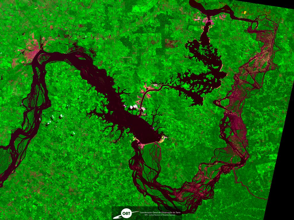
Featured Image: Coordenação-Geral de Observação da Terra/INPE, CC BY-SA 2.0, via Wikimedia Commons
In February, IBAMA, Brazil’s environmental agency permitted Belo Monte mega-dam operator Norte Energia to drastically reduce flows to the Volta Grande (Big Bend) of the Xingu River for at least a year. That decision reversed an earlier ruling to maintain much higher Xingu River flows and the fishery — as legally required.
The flow reduction will leave 70% of usually-flooded forest dry this season, causing massive fish mortality and diminished reproduction, experts say. Community group Xingu Vivo Para Sempre denounced the decision as “a death sentence for the Xingu” and demanded IBAMA’s and Norte Energia’s presidents be “criminally prosecuted.”
Norte Energia has funded projects to mitigate the reduced flow, collecting and dropping fruit into the river for fish to feed on, and releasing captive-bred fish. But scientists say these approaches are unscientific and will likely be ineffective, and can’t make up for the loss of the river’s seasonal flood pulse, upon which fish depend.
Residents say the government has spread misinformation, telling Brazilian consumers that their electricity bills would go up if Belo Monte released more water to maintain the Xingu’s ecosystem — something Norte Energia is obligated to do. At present, water levels on the Volta Grande have not been restored.
Bel Juruna, of the Juruna (Yudjá) Indigenous people, points her camera at the Xingu River, beside which she lives in Mïratu village in the Paciçamba Indigenous Territory on the 130-kilometer (81-mile) Volta Grande (Big Bend), in Pará state, Brazil.
The video shows a shoulder-high, light-colored waterline streaking a dark exposed boulder. Just days before, that boulder was mostly submerged and the river ran at a much higher level, but its flow has been drastically, suddenly, intentionally, and possibly illegally, reduced — threatening the Xingu’s fishery and the people who depend on it for food and livelihoods.
On February 8, Belo Monte mega-dam operator Norte Energia received permission from IBAMA, Brazil’s environmental agency, to immediately reduce river flows to less than 13% of normal — shifting the water to the dam’s electricity-producing turbines. This dramatic flow reduction was completely unanticipated by riverine Indigenous and traditional peoples, Bel’s video shows the effects: canoes with outboard motors stranded on dry rocks, aquatic vegetation exposed to the air.
“These plants are usually on the bottom [of the river]; they are water plants. And because the water won’t come [here] any more, they’re all going to die,” Bel says.
Norte Energia’s action comes during the piracema, a time of year when fish should be traveling on seasonally rising waters, deep into the flooded forest to feed and spawn. The government’s water reduction decision effectively closes the door on this reproductive window — an opportunity that comes but once a year.
“The Volta Grande will turn into a cemetery. A cemetery of fish, a cemetery of dead trees,” Bel says.
Norte Energia’s Hydrogram B permitted
In the second week of February, Norte Energia diverted more than 85% of the Xingu’s normal flow away from the Volta Grande, where thousands of Indigenous and traditional fisherfolk live. The company’s diversion to the Belo Monte dam reduced river flow abruptly from early-February speeds of 10,900 cubic meters per second (m3/s) to 1,600 m3/s. (The historical average flows before the dam was built were 12,736 m3/s.)
On February 8, IBAMA president Eduardo Fortunato Bim signed an agreement allowing Norte Energia to implement the company’s so-called Hydrogram B, an artificial hydrological regime that will remove 73% of normal annual Xingu River flows from the Volta Grande.
The socio-environmental consequences, say experts, will be catastrophic. Hydrogram B “will cause the end of the cyclical, ecological phenomenon of the [annual] flood pulse, which guarantees fishes’ and turtles’ access to their feeding areas. There will be high amounts of mortality and, in those [aquatic animals] who survive, loss of nutritional condition,” Juarez Pezzuti from the Federal University of Pará wrote in an email to Mongabay,
Turtles, of “extremely high cultural significance” to the Juruna and other riverine people, “will no longer be able to accumulate the energy necessary to produce eggs. The number of times they lay eggs and the number of eggs per nest will be drastically reduced.”
In a note to Mongabay on Hydrogram B’s effects, Norte Energia states, “There is no technical-scientific proof, nor any indications at present, that the flow [regime] practiced by Belo Monte can cause mortality of fish or turtles,” citing “robust monitoring.” Independent scientists allege Norte Energia’s monitoring studies are flawed.
Lorena Curuaia, a leader of the Curuaia people, of Iawá village, sent Mongabay audio commenting on IBAMA’s decision: “This is absurd. Once again, we see the fauna, the flora, totally threatened, especially all the biodiversity. We know that the normal flow of water on the Volta Grande and the whole Xingu Basin doesn’t work that way.
“So they are assaulting nature again. To do what?,” she asks. “To generate energy, to generate financial gain for them, unfortunately leaving biodiversity to the wayside? We are indignant.”
The leader demands, “We want a response from IBAMA itself, saying why they accepted this from Belo Monte.” IBAMA did not respond to requests for comment for this article.
Norte Energia’s studies on Hydrogram B rejected as faulty
In 2009, IBAMA’s technical team rejected Norte Energia’s extreme low flow Hydrogram B proposal as being unable to maintain life on the Volta Grande, something the Belo Monte dam operator is legally mandated to do. In December 2019, IBAMA ordered Norte Energia to study alternative hydrological regimes.
But when IBAMA reviewed the new studies, submitted in December 2020, they found that Norte Energia had only presented an analysis of Hydrogram B versus the historical natural flow, and had offered no alternative flow plans. This limited comparison made it impossible for experts to analyze alternative hydrological regimes, says Pezzuti. Agreeing with that assessment is Camila Ribas of the National Institute for Amazon Research and the American Museum of Natural History, after she had access to the studies.
Consequently, on February 2, 2021 IBAMA’s technical team rejected Norte Energia’s studies as “faulty” and incomplete.
What should have happened next, says Ribas, is Norte Energia should have had to redo its studies, addressing IBAMA’s critiques, and then resubmit. Until then, IBAMA’s “provisional hydrogram,” with higher river flows — in place since April 2019 — should have continued.
Political pressure on IBAMA and misinformation
But IBAMA allegedly received intense pressure from other ministries within the Jair Bolsonaro administration, lobbying it to reverse its expected upcoming decision to maintain provisional hydrogram water releases to the Volta Grande. For two months, IBAMA had signaled that Norte Energia would have to return significant amounts of water to the river to prevent further ecosystem harm.
Meanwhile, Ribas recalls that the Mines and Energy department and the electricity agency ANEEL “leaked supposedly internal documents” to the press, claiming that if IBAMA ordered Norte Energia to divert less water from the Volta Grande, then Brazilian consumers’ electricity bills would jump dramatically in cost.
That claim, according to Ribas and Pezzuti, is false.
According to Pezzuti, “The company claimed [Belo Monte’s] non-production of energy would make it necessary to produce energy by activating thermoelectric plants” to make up an energy shortfall, which would supposedly greatly raise costs. But, he says, Norte Energia had presented outdated data on Brazil’s hydroelectric reserves, giving a false picture of Brazil’s current hydroelectric energy potential.
In fact, in the current rainy season, Amazon hydroelectric reservoirs are full. “The majority of hydroelectric plants [in Brazil] have a good level and flows, and so less energy [coming from] Belo Monte won’t generate the [electricity] deficit that’s being threatened by the press and the government,” says Pezzuti. Norte Energia did not respond to Mongabay’s question on this matter.
Political interference and an environmental crime?
Apparently, IBAMA president Bim contradicted his own technical team’s conclusions to strike the February 8 agreement with Norte Energia’s president, Paulo Roberto Pinto, allowing the company to immediately implement Hydrogram B.
Bim is thought to have circumvented IBAMA organizational procedures and overruled his own director of licensing Jônatas Souza da Trindade, who should have made the decision, notes Pezzuti. In a note to Mongabay, Licensing General Coordinator Régis Fontana Pinto stated, “The decisions pertinent to the application of the Belo Monte [dam] hydrogram are taken in the purview of IBAMA’s president, though supplied with information by the technical team, by me as General Coordinator, and by the Environmental Licensing director.”
This agreement directly violates Article 231 of Brazil’s 1988 constitution, Pezzuti says, which states that hydroelectric plants can’t impact Indigenous lands. It also appears to violate international conventions such as ILO 169, ratified in Brazil as Decree 5,051, which protects traditional activities such as fishing as essential for cultural preservation. Further infringed regulations may include Law 11,346 ensuring Nutritional and Food Security, Law 9,985 protecting “the natural resources necessary for traditional populations’ subsistence,” and Decree 6,040 guaranteeing “traditional peoples’ access to natural resources for their physical, economic, and cultural reproduction.”
Concerning projected losses to the diets of Amazon fisherfolk, Lorena Curuaia told Mongabay, “No company has the right to take away another’s dietary sustenance. The fisher people’s culture is fish. To remove their food, is to remove their life.”
On February 18, dozens of fisherfolk organizations, all members of the Xingu Vivo Para Sempre association, formally demanded Eduardo Fortunato Bim and Paulo Roberto Pinto be “criminally prosecuted” for environmental damages resulting from IBAMA’s decision.
“In my understanding, if the president of the environmental organ takes a decision that contradicts the technical position of the institution itself, he is failing in his duty. He is committing a crime in failing to act in accordance with his function, which is to protect the environment,” Pezzuti states.
In a note to Mongabay, Norte Energia states, “There is no crime practiced — since there do not exist any environmental damages, but rather impacts [already] predicted” in the environmental licensing stage. In 2020, federal judges and IBAMA’s team documented that impacts of the dam, characterized by IBAMA as “grave and irreversible,” were greater than projected during licensing.
Norte Energia offers mitigation plans
In its February 8 IBAMA agreement, Norte Energia also committed $R 157 million (US$ 28 million) to river flow mitigation plans. Three projects were approved: to send teams to collect fruit and leaves from the forests that should have been flooded, then throw these into the reduced area of the river where fish are trapped; to build floating platforms with bushes for fish to feed from; and to breed fish in captivity and then release them into the Xingu.
Pezzuti rejects the plan as scientifically unproven: “It’s an absurd pseudo-project, impossible to be executed on a scale that compensates for the [absence of] flooding of tens of thousands of hectares.” He notes, “The first two [projects] aren’t based on any kind of precedent,” and the raising of fish in captivity in the hopes of repopulating the river “already has proven to be ineffective in several studies.”
Alexander Lees, of England’s Manchester Metropolitan University, concurs that these are unworkable solutions, “a waste of money” better spent on maintaining the ecosystem.
“Messing around with chucking fruit into rivers or floating trees is just throwing money away,” says Lees. “It just looks like good publicity,”
Bel Juruna says Norte Energia’s present efforts are ineffectual. “There are lots of companies [contracted by Norte Energia] here that go around, visit, hold meetings, but despite that, there aren’t any projects from the [original] Basic Environmental Plan that are working here.”
Pezzuti explains that Norte Energia’s fisheries mitigation plan was “signed off on by professors employed by public research universities, contributing to this scientific makeup, as if there were a solution for the tragedy that Hydrogram [B] will cause.” However, he adds, independent researchers, not paid by Norte Energia, “experts in fish ecology and aquatic turtles… vehemently protested… this bizarre proposal,” as did “IBAMA’s analysts, who rejected it” on February 2.
Ribas adds, “The research Norte Energia and its consultants do is already directed toward a certain end goal.” She believes that the company-contracted researchers’ finding that Hydrogram B is viable resulted from a conflict of interest which, she says, might explain why the firm’s experts didn’t present analysis of alternatives. “That’s not science,” she says, but Ribas is concerned the Brazilian public will accept the flawed research as valid.
What’s needed, she concludes, is independent monitoring. Ribas and her fellow scientists are seeking funding to monitor the effects of Norte Energia’s Hydrogram B on the Volta Grande in 2021.
As for the Juruna people, Bel Juruna says they will endure:
“We will be here. We want to resist in this place, fighting so that we, too, won’t turn into a cemetery in our village.”
This article was published in Mongabay on the 8th March 2021. You can access the article here.
Editor’s note: In this excerpt, Samir offers an outline of the rationale for the harmful development of lithium mines. In parallel we are also offered an outline of the development of the protest camp. While we are happy that a popular outlet like Vice News is writing about our campaign, we do not agree with all of the author’s statements. DGR is strongly opposed to any kind of industrial processes like mining because they are inherently destructive to life on planet earth. Hence we do not believe that there can be a “greener” kind of industrial resource extraction.
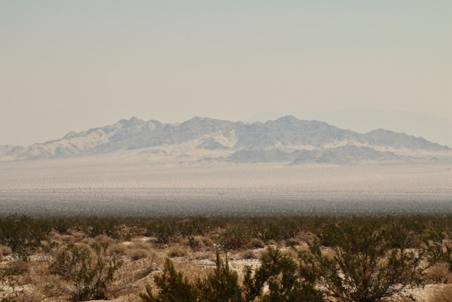
A mining giant wants to extract lithium from the Nevada desert to power electric cars. But a more sustainable future doesn’t come without costs.
One of the largest known lithium deposits in the world has sat undisturbed under the Nevada desert for centuries. Now, a mining giant wants to extract the resource to power electric cars using a potentially harmful method.
Before bringing in its equipment, however, the company will have to go through a blockade of environmental protesters that have been camped out at the site since December.
“Like the wildlife, we hunker down when the weather gets very bad and wait for the storm to break,”
said Max Wilbert, who started the Protect Thacker Pass, the grassroots organization leading the occupation.
“But we’re not backing down. What is at stake here is the soul of the entire environmental movement.”
Right now, Thacker Pass, a section of public land stretching hundreds of acres in northern Nevada, is several environmental permits—and lawsuits—away from becoming a massive open-pit mining project run by Canada-based Lithium Americas. The metal excavated from the planned 18,000-acre site will be used to manufacture rechargeable lithium-ion batteries for electric cars.
But a more sustainable future doesn’t come without its costs:
The proposed mining process at Thacker Pass uses sulfuric acid, which could seep into the water supply. The operation also requires tapping into groundwater, which could decrease its availability. Both would impact the ecosystems of several at-risk species, like golden eagles, pronghorn antelope, and Nevada’s state fish, the Lahontan cutthroat trout.
In an effort to protect the land, dozens of protestors from across the country have posted up at the site in freezing nighttime temperatures with heated tents and portable mini-toilets. Local ranchers, concerned about the welfare of their land and water supply, have also joined the cause.
The original article can be read in full on Vice News.
This essay is a firsthand account of the author Michael Drebert’s visit to Boundary Bay, BC — a shallow bay fringed in-part by a man-made dike, and estuarine marsh. Through his recollection of the visit, Drebert discusses how different forms of ‘taking’ from a particular place can be both obvious, but also inconspicuous. Most importantly, the essay asks what a meaningful response to such activities might entail.
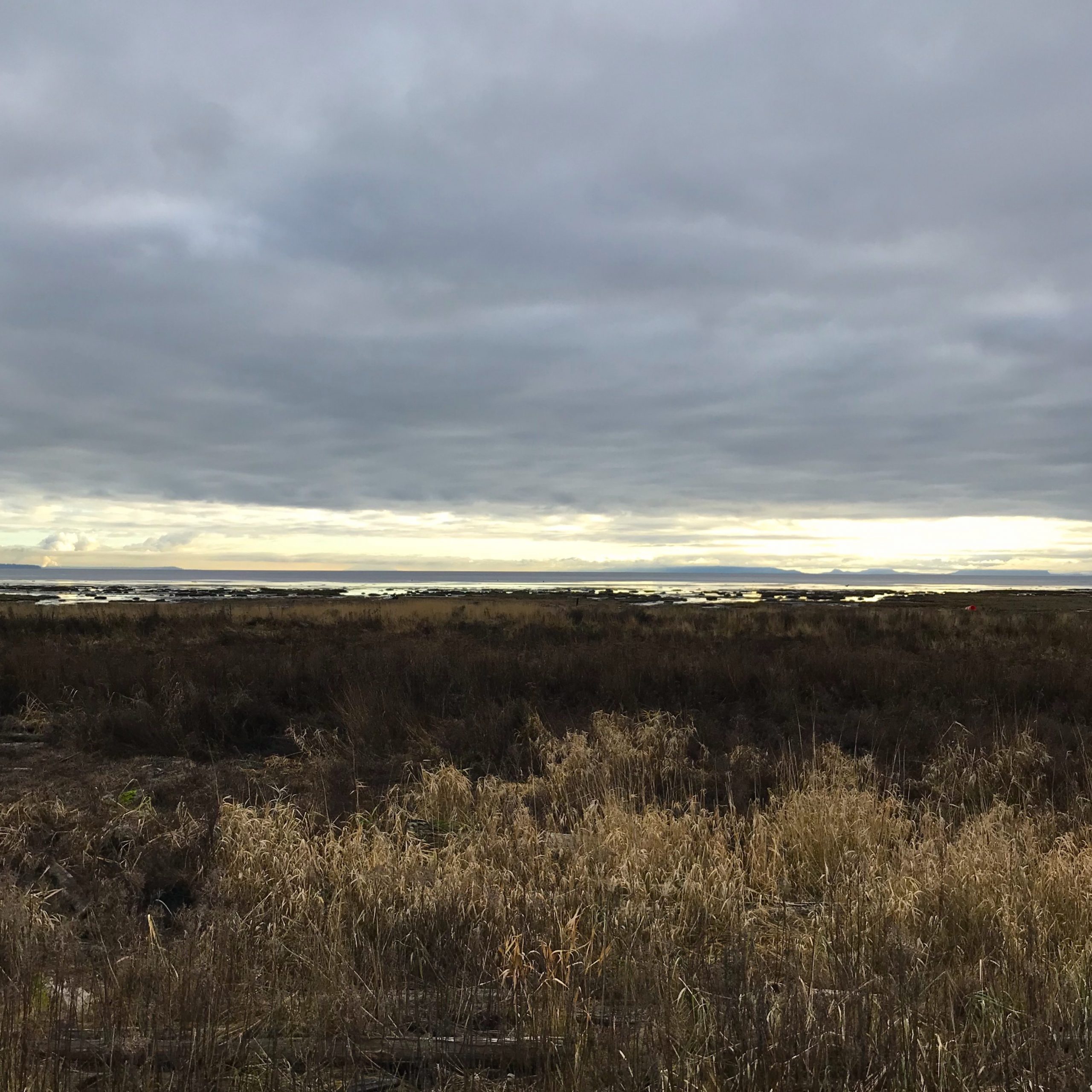
Last week, I decided to throw my bicycle into the back of my ancient Ford truck and head south out of the city. My destination was a place that I’ve been visiting since youth: Boundary Bay, a shallow body of saltwater spanning the municipalities of Tsawassen, Delta, Surrey, and White Rock.
It’s the White Rock portion of the bay that I recall from my youth. My grandmother would take my brother and I to its beach during summers, where we’d be allowed to range freely over the massive stretch of exposed sand at low tide. For hours, we’d wade into the warm tide pools, chasing sculpins, and small crabs. But the prize activity, was the building of a sand fort. Together, or apart, we’d spend what seemed like an entire day constructing raised platforms of sand that were then walled as best we could against the incoming tide. It was pure joy to be sitting in our ‘forts’ as the quickly approaching water of Boundary Bay moved towards us.
Thirty-five years later, I still return to the bay.
Less so to that stretch of perfect sand, but instead to an area on the opposite side. My excitement remains the same as in those early years, except that my attention has now shifted from its sand flats, to its mud flats.
In this section of the bay, there are preserved portions of what would have originally been coastal salt marsh. Less than 100 years ago, this form of habitat would have been prominent around the entire bay. With the influx of settlement by Europeans, residences were built along the shoreline. Attracted by, and taking advantage of the fertile, alluvial soils, these settlers engaged in intensive farming activities. As a result, dikes were built around the majority of the bay to protect the farms. These constructions cut off the usual flow of biological activity between the what is now the seaward, and landward portions of the salt marsh. Although some culverts were also inserted, these semi-permeable structures equally separated the two places, blocking fish, and small mammals from freely traversing back and forth.
Regardless of all these intrusions, a fringe of intact wetland still exists here.
I consider it a gem, and it has captured my heart. Martin Shaw describes the mysterious process of being attracted to a place as being “claimed.”1 And so, I might say something like: this particular shallow body of water, with its fringe of brown-sand beaches, and scruffy marshes, has claimed me. This is a romance that has been in the works for over 35 years.
On that blustery December day last week, after driving out of Vancouver over a couple of bridges, past farmland, eventually parking at Centennial Beach on the west side of the bay, I came to spend an entire day considering my attraction to such a place, and how I might best respond. And now, reflecting on this memory, another relationship to that place emerges: ‘taking’, in this case my ‘taking’ of this remembrance from Boundary Bay. I think about how so often, on my countless visits to different beaches around my home of Vancouver, and also abroad, I’d pick up some stone, or shell that ‘spoke’ to me. If it ‘spoke’ to me enough, I’d usually put it into my pocket, and carry it home. Once inside of my apartment, it would sometimes sit on a shelf, or placed in a box along with a clattering and dusty array of other mineral, and calcerific objects.
For over 35 years, I’ve barely questioned this.
“Of course,” I’d say to myself, “why wouldn’t I take a token to remember a special moment, a special place?” In particular, I have a small collection of agate stones that I collected from different beaches on Haida Gwaii. They now sit in a circle formation on the window sill of my bedroom. Whenever I look at them, my mind seems to become awash in something; something like the wind, or the sun, or the intermittent heavy rains that would pass over the lonely beaches around Rose Spit. So yes, that does have meaning for me, some connection to natural processes that are nearly impossible to express within language.
Even if I’ve taken these things to help me remember a particular place — and although they are often compelling in their own right, as objects outside the context that I found them in — were they not also beautiful on some rain-drenched beach? Were they not beautiful to someone else? Or useful, or necessary?
I want to compare this piece of writing and the memories it expresses to these taken objects — no different then a found cockle shell, or a set of fine, sun bleached bones that belonged to a western sandpiper. My 40-something year old body had to be there, in Boundary Bay — where one object encounters another, or, a material presence, encounters another material presence.
In other words, this essay would be impossible without the physical presence of my body making its way 50 kilometres south, out of Vancouver, where I met the earthen barriers which surround the bay. And once there, riding on my bicycle all day until the sun went down, sweating heavily beneath my Gore-Tex jacket and breathing in cold air which also made my eyes tear.
So, yes, I do believe I’ve taken something.
And, it’s not that I think this is entirely wrong, because all living things take things out of need, survival, happenstance. But usually, for the whole cycle to continue giving, and taking, it has to happen, in one place, or, it must circle back to the very place that the thing was taken from. Using a more more poetic sensibility, Gary Snyder posits another way of saying this: that in acknowledging our (human) need to consume, it would be proper etiquette to then offer a “[s]ong for your supper,”2 in respectful response.
The consequences of taking from somewhere and never giving back are, of course, obvious. Eventually, there is little left to glean, and eventually, when we move beyond the limits of particular places, they break. When it comes to material items, it’s easy enough to understand when there is a failure of reciprocity, but I think this same sentiment can be also be applied to ‘getting’ stories, as well.
To get this story (an account of some place where I do not live), I needed to go somewhere. This inevitably, and perhaps obviously implies ‘using’. My body needs certain things so that it can go places — it needs food, water, clothing, transportation. Where do these things come from? In the case of my visit to Boundary Bay, they almost certainly do not come from that place, but they do come from places, very real places.
Back to my very real, ancient truck, and back to that particular day, last week — along with these questions saturating my thoughts, it was also to my journey ahead that my mind now turned. I arrived at Centennial Beach, on the western side of the bay, around 1pm. The sky was grey, and there was a stiff breeze blowing in from the Salish Sea. I was a little nervous. Was this the right day to be attempting such a long bike ride along the dike? Will the weather continue to deteriorate, turning into rain, and stronger winds? There wasn’t time for second guessing. If I was going to do this, I had to leave right away so that I could get back to my truck before the park ranger locked the gates at 5pm. So I gobbled down some hard boiled eggs, and then off I rode heading towards the Serpentine River located at the eastern terminus of the dike.
The wind was unusually cold, biting at my face and neck.
Except for one, very thin line of bright yellow out towards the Gulf Islands, the sky was solid cloud in all directions. Even though all of this felt less-than-ideal, there was no turning back — I was committed. It didn’t take long before I started seeing bald eagles standing on the mudflats, and perched overhead on the power lines. Eventually, it seemed there was an eagle on every pole, and when I passed beneath looking up, the massive raptors would return the stare. This exchange made me shiver in a way to which I was totally unaccustomed. I thought: “What is stopping these creatures from swooping down with their bright yellow feet, tearing at my neck and carrying off a piece of my flesh to be eaten casually on the mudflats?” I’ll admit that one particular stare was so intense that I lost composure on my bike, wobbling as I sensed a feeling of nausea rise in my throat.
Things were different here. Even though I could still see the distant high-rise buildings of Vancouver, it all seemed so fragile, so vulnerable. Or at least I felt vulnerable, coasting along that thin hump of land meant to keep the salt marsh and all of its inconsistencies out of our human hair.
Half way along the dike, I noticed that the sky had lightened. I wasn’t sure that the weather was going to flip towards ‘pleasant’, but I am a sucker for any sign of sun — it can change everything for me. I also wasn’t particularly cold anymore — probably because of my constantly pumping legs over the smooth, gravel path.
Aside from the eagles, I was distracted from my cycling by many other birds.
In particular, the red-tailed hawks, who would casually swoop across the dike looking for food in either the salt marsh, or the farming fields. I also noticed many birdwatchers, carrying cameras with lenses as big as my legs. I was glad to these folks. Perhaps I sensed a kind of kinship. I rarely take composed pictures of wildlife, but I do look, stare, soak in, and strain to store particular sights into my memory. I think it’s a very similar activity, except I cannot claim any craft here, which certainly plays a role in my fellow kin’s activity out there on the marsh.
However, a pang of discomfort hit me as I considered this commonality. Again, back to my thoughts and feelings of ‘taking’ something from a place. No doubt these camera operators are taking something. Taking images, but also, in order to take these snap shots, the very device used to do so contains within it an incredible array of ‘taking’. Those cameras, worth more that two years of my annual income, undoubtedly come from some place else. The industrial processes involved in procuring such materials, always does harm to particular places. Put more succinctly, Lierre Keith states that, “[i]n blunt terms, industrialization is a process of taking entire communities of living beings and turning them into commodities and dead zones.”3
Another example of this process is the building of dikes, in order to facilitate industrial agriculture. To my right, is a living (although greatly diminished) salt marsh, and to my left is a dead zone of industrial processes which includes pesticides, fertilizers, and heavy tilling. One side allows for myriad life forms to flourish, and the other side is manipulated solely for human-use.
Is it too heavy-handed to say that one side is beautiful, and the other, is ugly?
It might be good to return here to my own initial discomfort of being physically present at Boundary Bay. Clearly, I also use harmful things. The most obvious thing being my truck. And so in an exacting sense, Snyder’s admonition is unavoidable for me. Truly, what is my song for my supper? The supper in this case might be all the elements which got me out to Boundary Bay, but also for this feast of the senses which has turned into this essay.
Is this essay then, my song? In part perhaps, but it remains an incomplete melody. On its own, it lacks the consonance of return. What I mean is that as a piece of writing, it remains within the realm of human nourishment, or meaning. At worst, it only increases the echo chamber effect of human culture, further dividing humans from their true responsibilities to the real, material health of particular places. More so, it gives the illusion of a completed cycle, inevitably leading to further breakage, and increased ‘taking’.
The time it took to get to the Serpentine River was more than double than what I anticipated. I allowed myself to forget this momentarily as I was in need of food, tea, and a place to relieve myself. I only took 20 minutes to rest, where I sat on granite boulders gazing out at the exposed mud flats of the Serpentine River estuary.
The sky at this point had completely changed.
Late afternoon sun poured over the bay, and a near full moon was rising. To make it back to the truck before the gates were locked, I would have to increase my speed by double to make it. There wasn’t time to question my ability here. No one else was embarking along the dike towards Centennial Beach. It was likely too late in the day for most people — the temperature dropping, and nearly time for supper. With the bright moon continuing to rise, I raced out back along the dike, my legs pumping with renewed zeal.
Large birds still crossed overhead, but because the light had diminished, they now seemed like very unusual objects. They were vague, but still intimidating, blending with the browns and the purples of a day-about-to-end. There was one exception to this blurring of life, and it was a phenomenon that I’ve witnessed a few times before. Close to sundown, large flocks of western sandpipers appear together over the water’s edge. Not unlike a school of herring will move, their tiny bodies fly together as one shimmering, and amorphous shape. But what makes this particularly shocking to me, is what happens at sunset.
When the sky is pink, and I happen to be facing the direction that can then view their bellies, all of a sudden, I’ll see a burst of tiny pink flashes — their white undersides acting as perfect screens, reflecting the bay’s show of evening light. After witnessing the sandpipers, I could see that the moon had climbed to the top of the sky — against dark indigo, its snowy glow cast a reflection onto the calm waters of the bay. I had just entered the bounds of Centennial Beach, and felt a rush of calm — I made it, just in time.
I only had a few minutes to load my bike.
The park ranger was weaving her truck slowly through the parking lot, orange lights flashing, letting everyone know that the gate closure was imminent. As my truck warmed up, I ate my remaining potato chips — I was utterly famished. Could I stay the night? Perhaps, but my cupboards were in another place. And so with mixed reluctance I drove my old truck out of the park bounds, pointed it northwards, and headed home towards Vancouver.
I’m writing this now, in my studio. I like to have the door open, but the weather is too cold — being mid-winter on the northwest coast. I like the door open so I can feel the breeze, and to better hear the bird calls. Though, because my yard and my neighbour’s yard are packed with plants, there are a lot of birds present regardless of the season. And even though the door is closed, I can still hear intermittent chirps, trills, and lilts. I don’t know what I would do without this lush garden, and all the visiting animals. Living in the city would be impossible, otherwise.
Given just a little more thought, my appreciation of this garden can flip, completely. In short: the horrors of the city are made acceptable, because of this tiny retreat. Take away my access to this, and I am a very different person. Even a degraded version of ‘land’ lends me the needed salve to continue an urban life. Less a salve perhaps than a balm, for I cannot attribute any medicinal qualities to its makeup.
This quality makes me think about the Tsawassen and Semiahmoo peoples who inhabited Boundary Bay long before European settlers.
It would seem that true medicine is ‘offered’ to those who live in a particular place, so that they can continueliving well in that particular place. Not to heal, and then leave. I would say that pocketing a unique shell, collecting an image in a camera, storing an experience in your mind and heart to be retold later, is similar to this ‘leaving’ experience. It is a draining off of life, taken from a place where it has no opportunity to perish, to decompose, to nurse new life — it breaks the elegance of a necessary cycle.
I don’t live at Boundary Bay, on the ‘right side’ of the dike. That would be impossible, mostly. My fumbling attempts at trying to hunt, forage, and build shelter would no doubt further harm that place. And so, in-line with my interest to pay for my debt of visitation, I decide to pause, and attempt to ask Boundary Bay: what is it you might want, or need? Although my asking is somewhat awkward — sitting in this small studio miles away — one answer comes surprisingly quickly: simply remove the poison.
In the physical, material world, poison is always harmful, and in many cases, deadly. What then might the material poisons in this particular place be? The dike which stretches along the bay, is a simple technology, but it only serves one species. It is effective, very effective in separating the wild processes, from the hyper domesticated processes of city living. But the harm of this dike, the poison of its material intrusion, affects thousands of species, negatively.
Pausing at my desk, my mind flickers back to those childhood memories of my brother and I building sand forts at White Rock Beach. During those countless afternoons, I would often glance back at my grandmother. She was usually sitting in a collapsible deck chair, perched on a sand bar — her oversized sunglasses turned in our direction — and always smiling. As the tide quickly approached, we rushed to complete our forts feeling safe, completely safe.
Even then, I knew that our efforts to keep the cool saltwater at bay, were ultimately futile, that our constructions would eventually collapse.
But still we did our best to play the game: whose fort would last the longest? I count these as some of the most fun, and enjoyable moments of my entire life. If an incoming tide ever began to break up the dike at Boundary Bay, I don’t think I’d be sad, or frustrated. I might even smile: understanding that this is how it should go, that this is natural, or helpful. I might also recognize my kinship with the cool saltwater of the bay, and decide in my own way how to lend-a-hand.
And while I did this work, I might even sense the smile of something, or someone, much older than I: her calm and caring love taking delight in the work of her family. Perhaps then, simply: acts which remove poisons, could be our songs for our supper — a chorus of gratitude for the gift of being alive. And perhaps this kind of singing will attract others to the work, creating meaning and social bonds amidst the places we love,4 healing divisions within human culture, and the land.
Michael Drebert is a writer, gardener, and member of DGR living in Vancouver, Canada. When he isn’t knee-deep in a salt marsh, or rowing a small boat in a local waterway, he’s writing about his love of coastal areas and the need to protect them.
1 Martin Shaw, Scatterlings: Getting Claimed in the Age of Amnesia (Ashland, OR: White Cloud Press, 2016).
2 Gary Snyder, Back on the Fire: Essays (Berkeley, CA: Counterpoint, 2007), 34.
3 Aric McBay, Lierre Keith, and Derrick Jensen, Deep Green Resistance: Strategy to Save the Planet (New York, NY: Seven stories press, 2011), 23.
4 Chris Hedges, “The Politics of Cultural Despair: That’s What’s Killing Us, Not Donald Trump,” Salon (Salon.com, November 1, 2020), https://www.salon.com/2020/11/01/the-politics-of-cultural-despair-thats-whats-killing-us-not-donald-trump.