by DGR News Service | Nov 16, 2020 | Biodiversity & Habitat Destruction
by Blake Lavia and Tzintzun Aguilar-Izzo / Talking Wings Collective
Oct 9th, 2020, Movimiento por la Defensa de la Sierra, Coatepec, Veracruz, Mexico
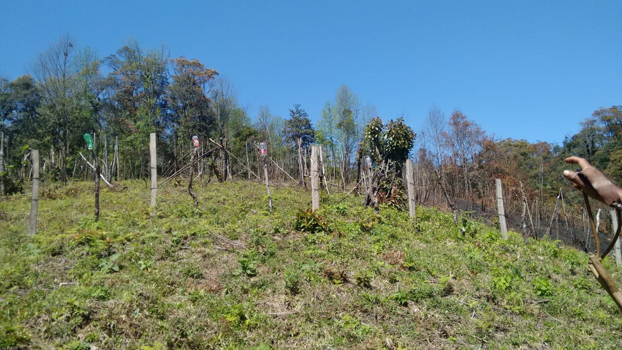
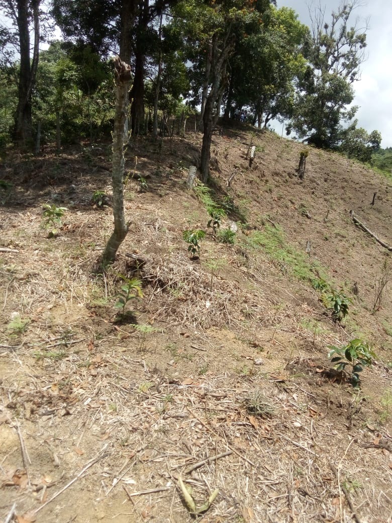
Five thousand acres of cloud forest are currently being threatened in Coatepec, Veracruz, Mexico. This land is, at present, being held by squatters, who, with the backing of local politicians, have claimed to be the forest’s rightful owners. They displaced dozens of families and are threatening one of Mexico’s most vital ecosystems. These 5,000 acres of land contain three municipal parks and one archeological site. While the land’s original stewards and forest protectors are engaged in a legal battle with the “invaders,” the deforestation of this fragile ecosystem has already commenced. This act of environmental devastation has wide political/economic ramifications. If you control Coatepec’s mountains, you control the subsistence and livelihood of millions.
The Coatepec Cloud Forest
The cloud forest above Coatepec is known as “la fabrica de agua” (the water factory). It is one of the last “water factories” of its kind in Mexico, and it moderates the weather of the entire region. The clouds that roll in from the Gulf of Mexico are captured by the forest canopy, the moisture forming a thick mist that shrouds the mountainside. Trees, moss, and orchids collaborate in an infinitely diverse ecosystem to retain the water that feed the region’s rivers, bringing life to the valleys bellow. The cities of Coatepec, Xalapa, and Cardel rely on this water, not to mention most of the communities of central Veracruz.
Globally, cloud forests are bastions of biodiversity. They harbor animal, and plant that are threatened by the shifting tides of the climate crises and uncontrolled land use. Coatepec’s cloud forest now hosts 90 plant, animal, and fungal species on the verge of extinction. Coupled with the biodiversity loss, the destruction of this ecosystem holds serious repercussions for the entire watershed. Without the cloud forest, the rivers will run dry, and the entire region will see considerably less rainfall. In short, the destruction of the cloud forest will spell drought and devastation for all.
The Invasion
In January 2019, a faction of the “Central Independiente de Obreros Agrícolas y Campesinos” (The Independent Organization of Agricultural Laborers and Farmers) set up an encampment on the 2,000 acres of cloud forest known as the Jinicuil Manso estate. CIOAC verbally threatened more than 500 original stewards of the land and claimed to be the legal owner of the property. While the information is difficult to corroborate, local activist networks say that the organizers of the CIOAC encampment came from outside the region, and do not hold legal rights to the said property. The community members who own land in the Jinicuil Manso estate submitted complaints to the local authorities. While the government “invited” the squatters to move off the premises, they requested that the community members refrain from engaging directly with CIOAC, to prevent physical aggression.
The situation was further complicated in February 2020, when the local authorities issued a “measurement and demarcation notice,” requesting that all the landowners submit paperwork confirming their title to the land. Many of the land’s stewards were not aware of the government’s decree. Others did not have the paperwork to prove that they owned their properties, even though the land had been in their family for generations. The local government never specified the reasons for this “demarcation notice,” and never compared the documents submitted by the land’s stewards with those provided by CIOAC. Instead, they refused to consider the documents submitted, and appear to favor CIOAC’s land claim, a land claim that local activists argue has been falsified.
The Electoral Politics of Water and Land
The local community groups, such as “Por la Defensa de la Sierra de Coatepec,” and the individual landowners, are currently involved in court cases with CIOAC. Throughout the process, it has it became clear the larger political forces are involved in the illegal “settlement” of the cloud forest. The CIOAC members have direct connection with major political parties in the area, with whom they have garnered ample political support. In addition, they have publicly thanked the governor of the State of Veracruz, Cuitlahuac García Jiménez, for his backing (though it is unclear whether this was just political posturing on the part of CIOAC).
Land, environmental destruction, and electoral politics has been devastatingly intertwined in Mexico for decades. When CIOAC first “invaded” the cloud forest, they invited citizens from the surrounding regions to squat on the appropriated land. Community members who did not own land of their own, and/or were seeking greater financial stability, settled in the cloud forest. Forest protectors have observed between 100 to 300 community members in the encampments at a time. They cut down trees, hunt the local fauna, and set up their septic systems to run off into the precious streams. When forest protectors attempt to plant trees or talk with the squatters, the squatters respond violently. They have been known to brandish guns and machetes, defending the land that has been promised to them.
Political figures from various parties in the region have sought to partner with the CIOAC settlers, nurturing a solid voting block of support. Leading up to the future regional and national elections, the ruling political parties have reacted favorably to the CIOAC’s land claims. However, underneath the surface, the forest protectors and activists claim that there is an even darker story. The people that live in the encampments of Jinicuil Manso could also be serving as a human shield, emptying the land for a larger economic interest that seeks to control the most vital resource of all: water.
The Conquest of the Cloud Forest
While at first glance the squatters could appear to be land hungry farmers, they are in fact just a cog in the virulent political system. Local activists believe that the squatters could be a facade for a political and economic interest that seeks to take over the forest of the region. Nestle, Coca-Cola, and other international corporations have huge factories in Coatepec, and have been seeking to control the region’s water supply for decades. Over the last series of elections, the community members have seen this same political/environmental ploy play out, though not to this level of devastation.
Veracruz is one the deadliest regions for land and water protectors in the world. “Por la Defensa de la Sierra de Coatepec” continues to organize throughout the region, raising awareness about the plight of the cloud forest, and the people that have been displaced. However, the settlers began threatening the lives of the forest protectors. When the organizers tried to negotiate with them in person, they were attacked with machetes. In the end, the CIAOC managed to scare most of the forest protectors into silence by actively threatening their families, while local authorities have turned a blind eye.
Action
While many forest protectors are too afraid to speak in public or to the press, the fight is not over. On the 29th of November 2020, “Por la Defensa de la Sierra de Coatepec” will return to the stolen land to begin reforesting the trees that have been cut down. They will also initiate a barter market with the local community members who have been directly affected by the theft of land. While many forest protectors have been forced to move to surrounding cities to protect their families, they are willing to risk their lives to defend and bring life back to the cloud forest.
How You Can help!
– Follow the “Movimiento por la Defensa de la Sierra” on social media and share the story with everyone you know.
– Show your support by commenting on their page, and/or sharing a video of support.
by DGR News Service | Nov 13, 2020 | Biodiversity & Habitat Destruction
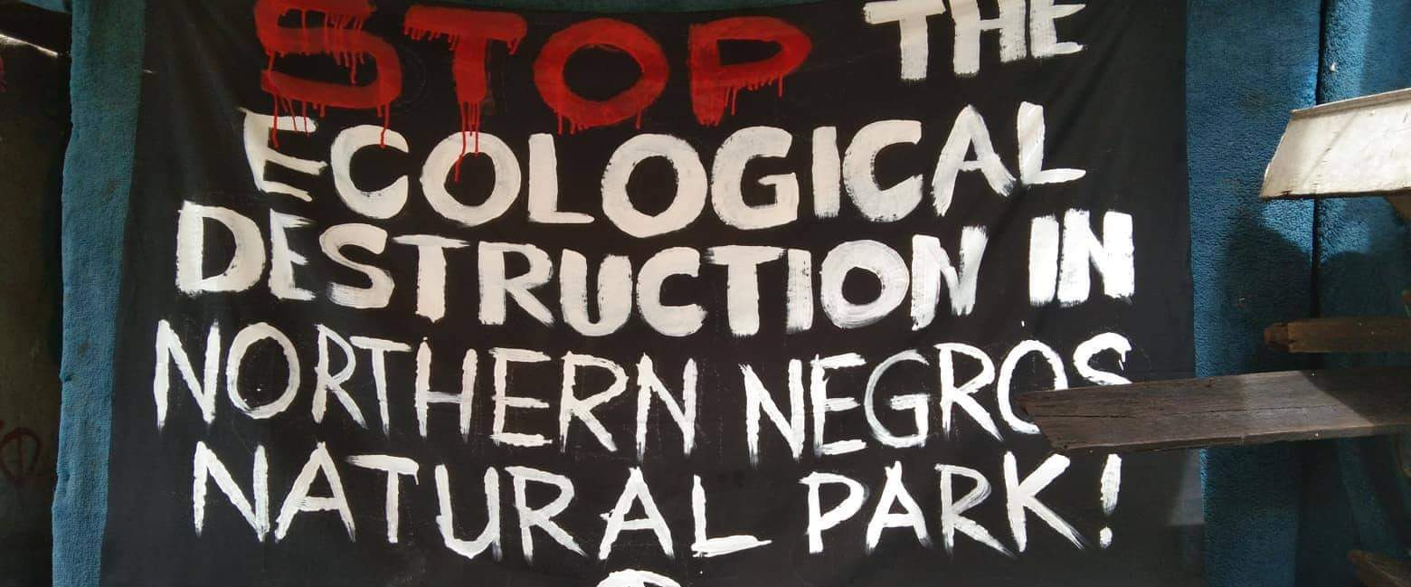
This article is based on communication from a comrade in the Negros province of the Philippines. There is ongoing destruction of the natural world in this area due to road construction, a planned airport, and clearing of the rainforest. The people on the front lines, being most affected, are calling for international solidarity and support.
On October the 18th this year, the first direct action regarding the Northern Negros National Park was taken by a group of concerned people. Food Not Bombs Bacolod Volunteers and concerned citizens have started a campaign to raise awareness about the ongoing destruction of the rainforest in the Negros area of the Philippines. The group has begun disseminating information to ensure other know about the ongoing harm being caused and to stand firmly IN SOLIDARITY WITH THE FOREST.
The group, focused their work in the city of Bacolod distributing printed placards, information flyers & leaflets and have been clear they are in direct opposition to any act of destruction. Food Not Bombs Bacolod condemns these injustices and the actions of the Local Government of Negros Island which sanctions the destruction of the remaining rainforest of the island.
About Northern Negros National Park
The Northern Negros Natural Park is a protected area of the Philippines located in the northern mountainous forest region of the island of Negros in the Visayas. It is spread over five municipalities and six cities in the province of Negros Occidental and is the province’s largest watershed and water source for seventeen municipalities and cities including the Bacolod metropolitan area.
The park belongs to the Negros–Panay Biogeographic Region. It is one of two remaining lowland forests on Negros island, the other being in the Dumaguete watershed area in Mount Talinis on the southern end of the island in Negros Oriental.
The park is a habitat to important fauna including the Visayan spotted deer, Visayan warty pig, Philippine naked-backed fruit bat, and the endangered Negros shrew.
Number of endemic and threatened species of birds have been documented in the park, which includes the Visayan hornbill, Negros bleeding-heart, white-winged cuckooshrike, flame-templed babbler, white-throated jungle flycatcher, Visayan flowerpecker and green-faced parrotfinch.
Flora documented within the park include hardwood tree species (Dipterocarps), as well as palms, orchids, herbs and trees with medicinal value. Very rare is the local species of the cycas tree (locally called pitogo), probably a Cycas vespertilio, considered living fossil from the times of dinosaurs. Another prehistoric flora is present in the park like the tree ferns and the also protected Agathis philippinensis, (locally known as almaciga).
While We Were Distracted
As we know during 2020 most nations have been preoccupied trying to survive lockdown. During this time the local government of Negros Island, Protection And Management Board, Department of Environment and Natural Resources (DENR) failed in its responsibilities to protect the remaining watershed and rainforest. Road construction on the island started in the midst of Global Pandemic.
Instead the DENR legitimized the road construction on the Island and in doing so has increased the likelihood of communities on the island being destroyed in the medium to long term. The DENR, along with the Department of Public Works and the Department of Highways have acted in a way that swept aside the needs of local communities, that ignored the rights of the natural world and in doing so have colluded to strengthen their power. In short they have become the mechanism and tool of destruction for the island.
The Aerotroplis Project
The plans to build a new International Airport in Manila has also hit the radar of environmental activists. The people and environmental groups in Bulakan and Bulacan have shared concerns about the devastation this will cause to the natural world, to wildlife (including fish) populations, bird populations, air pollution, and airplanes flying in the sky. As always the focus is on economic benefits rather than the health of planet or people. There has been little or no analysis of the environmental impact.
Leon Dulce, national coordinator of Kalikasan-People’s Network for the Environment (Kalikasan-PNE), told the BusinessMirror that the presence of the bird populations are bioindicators of good ecological health. He stated “This is of crucial importance in these times when there are multiple epidemiological risks from pandemics, socioeconomic loss, and climate emergency all emerging from the disrupted environment. Massive land-reclamation activities in Manila Bay threatens the last remaining wetlands where migratory birds roost. The Bulacan Aerotropolis is one of the biggest threats that will destroy 2,500 hectares of mangroves and fisheries. It is outrageous that transportation mega infrastructure is being touted for economic recovery when global transportation is expected to remain disrupted until 2021.”
Critical Mass Ride
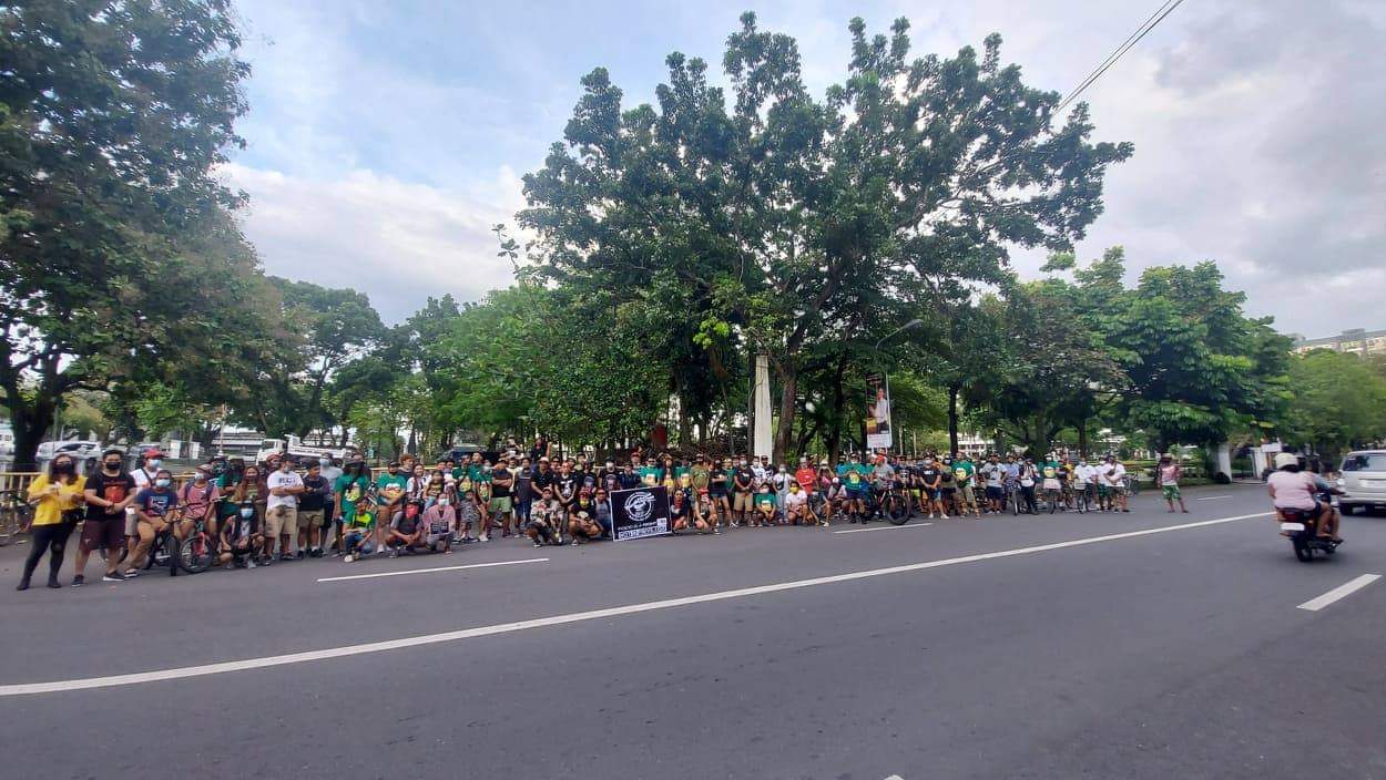 Following the actions from Food Not Bombs Bacolad, on November 8th Local Autonomous Networks held a discussion to consider the ongoing problem. They agreed to organize a coordinated Critical Mass Ride. The ride involved concerned people in the Archipelago from the different islands of the Philippines gathering to travel around the main city to raise awareness.
Food Not Bombs and Local Autonomous Networks have issued a call to action to support them in opposing the road construction and the subsequent destruction of the Rainforest that will kill the livelihood of hundreds of families.
The call to action in the Archipelago is just a start. They have been clear they will not stop nor be silenced until the destruction planned has been stopped. They are calling for International Solidarity to all readers.
Join The Resistance. Join The Fight!
Save the Remaining Forest & Watershed of Northern Negros Natural Park, Stop the Patag-Silay-Calatrava-Cadiz Road Construction. STOP the Bulacan Aerotropolis Project.
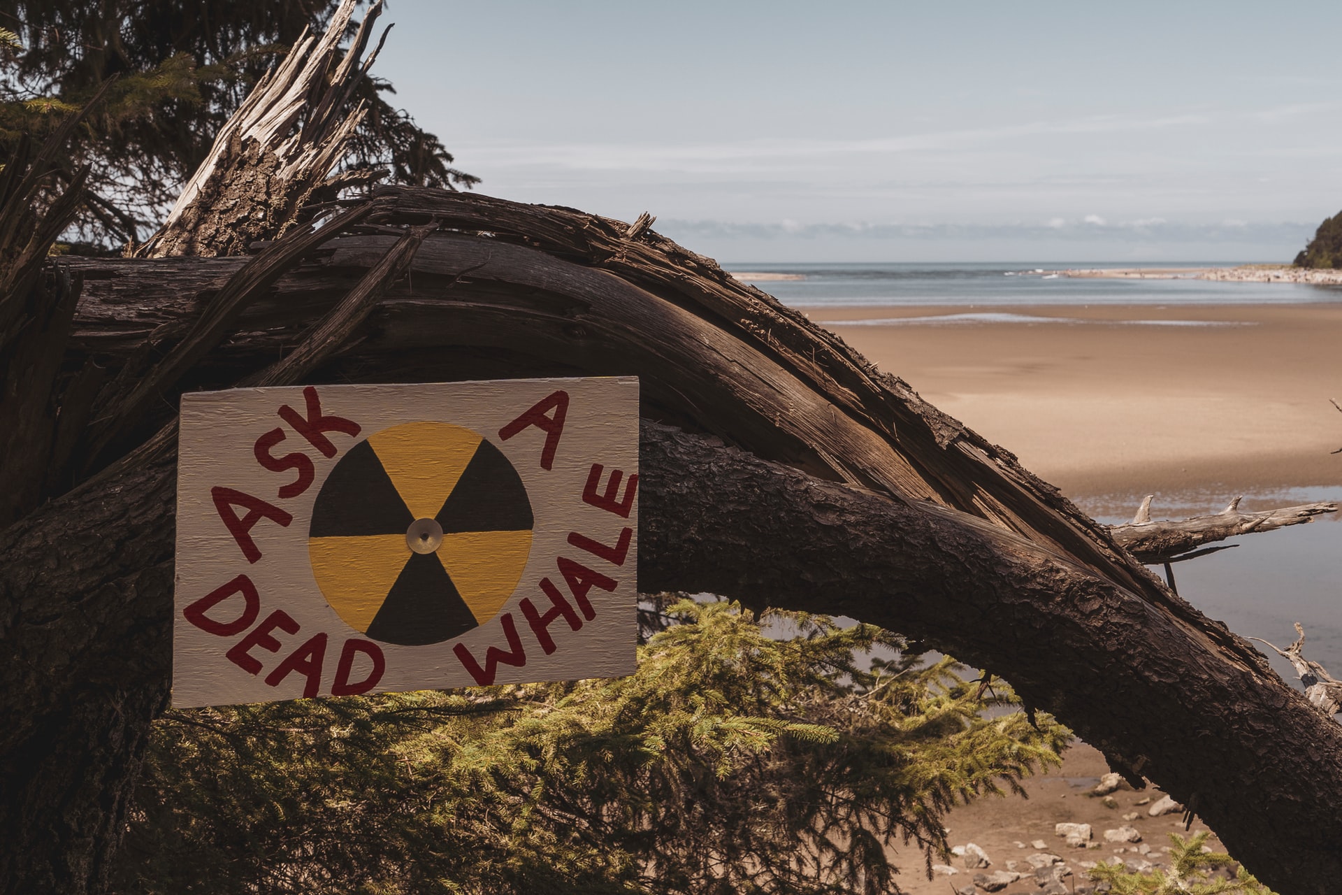
by DGR News Service | Nov 7, 2020 | Toxification
In this article, Robert Hunzinker writes about the current situation regarding the Fukushima Daiichi Nuclear Power Plant accident which has led to the spillage of radioactive water into the Pacific Ocean and also water containment issues with worrisome consequences.
By Robert Hunzinker / Counterpunch.
For nearly a decade the crippled Fukushima Daiichi Nuclear Power Plant has been streaming radioactive water into the Pacific Ocean. As it happens, TEPCO (Tokyo Electric Power Co.) struggles to control it. Yet, the bulk of the radioactive water is stored in more than 1,000 water tanks.
Assuredly, Japan’s government has made an informal decision to dump Fukushima Daiichi’s radioactive water into the Pacific Ocean. A formal announcement could come as early as this year. Currently, 1.2 million tonnes of radioactive water is stored.
The problem: TEPCO is running out of storage space.
Government of Japan’s solution: Dump it into the Pacific Ocean.
Third-party expert solutions: Build more storage tanks.
Environmental groups insist there is no reason why additional storage tanks cannot be constructed outside the perimeter of the plant. They accuse the government of seeking the cheapest and quickest solution to the problem. All along, authorities have promised the site will be safe in 40 years. Really, only 40 years!
According to IAEA’s Director General Grossi, who visited Fukushima in February 2020, dumping radioactive water that is mainly contaminated with tritium meets global standards of practice.
In that regard, advocates of nuclear power utilize a subtle storyline that convinces, and deceives, the public into accepting nuclear power, however reluctantly. It goes something like this: “There’s nothing to worry about. Nuclear power plants routinely release tritium into the air and water. There is no economically feasible way to remove it. It’s normal, a standard operating procedure.” Nevertheless, as shall be explained in more detail forthwith, there is nothing positive about that posture, absolutely nothing!
According to TEPCO, all radioactive isotopes will be removed, except tritium, which is hard to separate. Still, similar to all radioactive substances, tritium is a carcinogen (causes cancer), a mutagen (causes genetic mutation), and a teratogen (causes malformation of an embryo).
The good news: Tritium is relatively weak beta radiation and does not have enough energy to penetrate human skin. The principal health risks are ingesting or breathing the tritium.
TEPCO has deployed an Advanced Liquid Processing System that purportedly removes 62 isotopes from the water, all except tritium, which is radioactive hydrogen and cannot easily be filtered out of water.
However, the filtration system has been plagued by malfunctions. According to Greenpeace International, within the past two years TEPCO admitted to failures to reduce radioactivity to levels below regulatory limits in more than 80% of the storage tanks. Reported levels of Strontium-90 (a deadly isotope) were more than 100 times regulatory standards with some tanks at 20,000 times:
“They have deliberately held back for years detailed information on the radioactive material in the contaminated water. They have failed to explain to the citizens of Fukushima, wider Japan and to neighboring countries such as S. Korea and China that the contaminated water to be dumped into the Pacific Ocean contains dangerous levels of carbon-14. These, together with other radionuclides in the water will remain hazardous for thousands of years with the potential to cause genetic damage. It’s one more reason why these plans have to be abandoned.”
Cancer is the main risk to humans ingesting tritium. When tritium decays it emits a low-energy electron (roughly 18,000 electron volts) that escapes and slams into DNA, a ribosome or some other biologically important molecule. And, unlike other radionuclides, tritium is usually part of water, so it ends up in all parts of the body and therefore, in theory, can promote any kind of cancer. But that also helps reduce the risk because tritiated water is typically excreted in less than a month. (Source: Is Radioactive Hydrogen in Drinking Water a Cancer Threat, Scientific American, Feb. 7, 2014)
Some evidence suggests beta particles emitted by tritium are more effective at causing cancer than the high-energy radiation such as gamma rays. Low-energy electrons produce a greater impact because it doesn’t have the energy to spread its impact. At the end of its atomic-scale trip it delivers most of its ionizing energy in one relatively confined track rather than shedding energy all along its path like a higher-energy particle. This is known as “density of ionization.” As such, scientists say any amount of radiation poses a health risk.
You can read the full article here.
by DGR News Service | Nov 3, 2020 | Climate Change
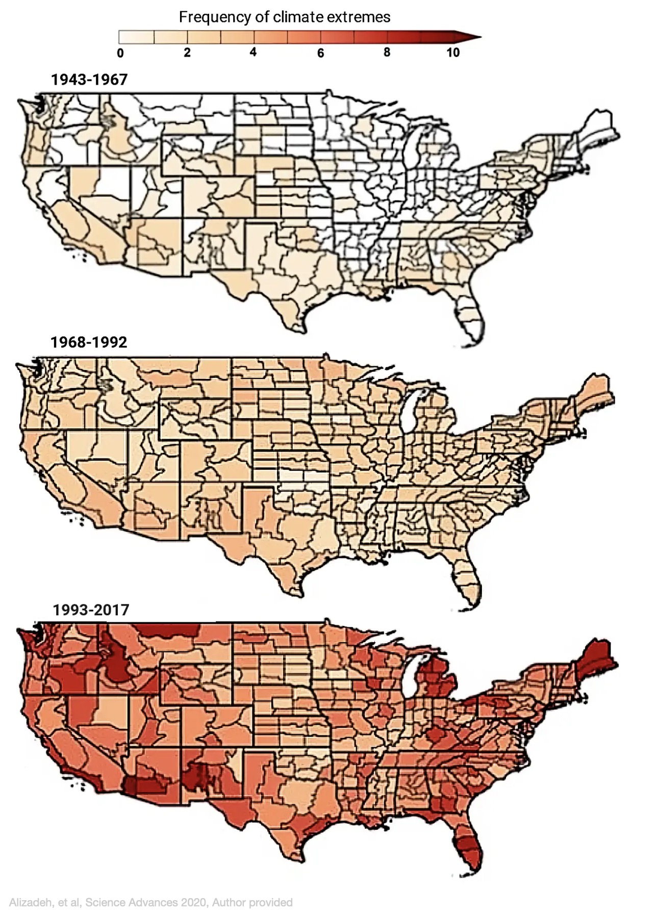
by Mojtaba Sadegh (Assistant Professor of Civil Engineering, Boise State University), Ata Akbari Asanjan (Research Scientist, Ames Research Center, NASA), and Mohammad Reza Alizadeh (Ph.D. Student, McGill University) / The Conversation
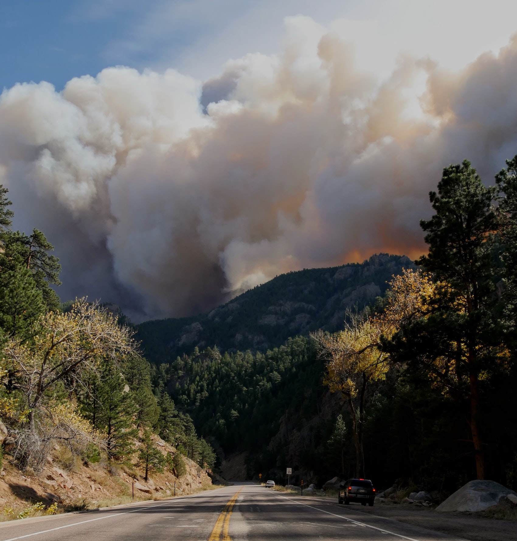
Two wildfires erupted on the outskirts of cities near Los Angeles, forcing more than 100,000 people to evacuate their homes Monday as powerful Santa Ana winds swept the flames through dry grasses and brush. With strong winds and extremely low humidity, large parts of California were under red flag warnings.
High fire risk days have been common this year as the 2020 wildfire season shatters records across the West.
More than 4 million acres have burned in California – 4% of the state’s land area and more than double the previous annual record. Five of the state’s six largest historical fires happened in 2020. In Colorado, the Pine Gulch fire that started in June broke the record for size, only to be topped in October by the Cameron Peak and East Troublesome fires. Oregon saw one of the most destructive fire seasons in its recorded history.
What caused the 2020 fire season to become so extreme?
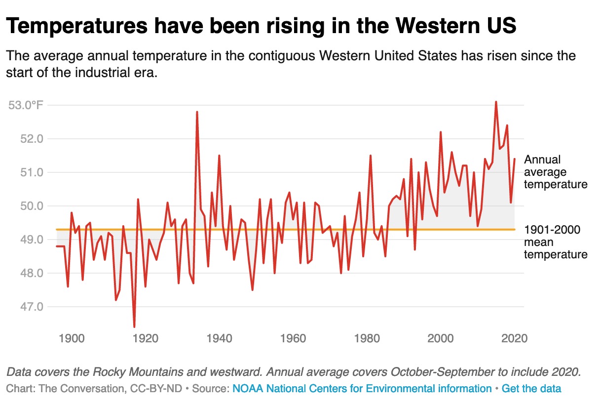
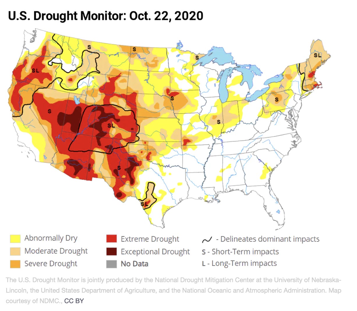
Fires thrive on three elements: heat, dryness and wind. The 2020 season was dry, but the Western U.S. has seen worse droughts in the recent decade. It had several record-breaking heat waves, but the fires did not necessarily follow the locations with the highest temperatures.
What 2020 did have was heat and dryness hitting simultaneously. When even a moderate drought and heat wave hit a region at the same time, along with wind to fan the flames, it becomes a powerful force that can fuel megafires.
That’s what we’ve been seeing in California, Colorado and Oregon this year. Research shows it’s happening more often with higher intensity, and affecting ever-increasing areas.
Climate change intensified dry-hot extremes
We are scientists and engineers who study climate extremes, including wildfires. Our research shows that the probability of a drought and heat wave occurring at the same time in the U.S. has increased significantly over the past century.
The kind of dry and hot conditions that would have been expected to occur only once every 25 years on average have occurred five to 10 times in several regions of the U.S. over the past quarter-century. Even more alarming, we found that extreme dry-hot conditions that would have been expected only once every 75 years have occurred three to six times in many areas over the same period.
We also found that what triggers these simultaneous extremes appears to be changing.
 During the Dust Bowl of the 1930s, the lack of rainfall allowed the air to become hotter, and that process fueled simultaneous dry and hot conditions. Today, excess heat is a larger driver of dry-hot conditions than lack of rain.
This has important implications for the future of dry-hot extremes.
Warmer air can hold more moisture, so as global temperatures rise, evaporation can suck more water from plants and soil, leading to drier conditions. Higher temperatures and drier conditions mean vegetation is more combustible. A study in 2016 calculated that the excess heat from human-caused climate change was responsible for nearly doubling the amount of Western U.S. forest that burned between 1979 and 2015.
Worryingly, we have also found that these dry-hot wildfire-fueling conditions can feed on one another and spread downwind.
When soil moisture is low, more solar radiation will turn into sensible heat – heat you can feel. That heat evaporates more water and further dries the environment. This cycle continues until a large-scale weather pattern breaks it. The heat can also trigger the same feedback loop in a neighboring region, extending the dry-hot conditions and raising the probability of dry-hot extremes across broad stretches of the country.
All of this translates into higher wildfire risk for the Western U.S.
In Southern California, for example, we found that the number of dry-hot-windy days has increased at a greater rate than dry, hot or windy days individually over the past four decades, tripling the number of megafire danger days in the region.
 2020 wasn’t normal, but what is normal?
If 2020 has proved anything, it is to expect the unexpected.
Before this year, Colorado had not recorded a fire of over 10,000 acres starting in October. This year, the East Troublesome fire grew from about 20,000 acres to over 100,000 acres in less than 24 hours on Oct. 21, and it was nearly 200,000 acres by the time a snowstorm stopped its advance. Instead of going skiing, hundreds of Coloradans evacuated their homes and nervously watched whether that fire would merge with another giant blaze.
This is not “the new normal” – it’s the new abnormal. In a warming climate, looking at what happened in the past no longer offers a sense of what to expect in the future.
“The growth that you see on this fire is unheard of,” Grand County Sheriff Brett Schroetlin said of the East Troublesome fire on Oct. 22. “We plan for the worst. This is the worst of the worst of the worst.”
 There are other drivers of the rise in fire damage. More people moving into wildland areas means there are more cars and power lines and other potential ignition sources. Historical efforts to control fires have also meant more undergrowth in areas that would have naturally burned periodically in smaller fires.
The question now is how to manage this “new abnormal” in the face of a warming climate.
In the U.S., one in three houses are built in the wildland-urban interface. Development plans, construction techniques and building codes can do more to account for wildfire risks, including avoiding flammable materials and potential sources of sparks. Importantly, citizens and policymakers need to tackle the problem at its root: That includes cutting the greenhouse gas emissions that are warming the planet.
Republished under a Creative Commons Attribution/No derivatives license.

by DGR News Service | Oct 31, 2020 | Climate Change
This article was written by BY ROBERT HUNZIKER and originally published in CounterPunch on OCTOBER 20, 2020. Robert offers the reader multiple sources of evidence regarding the nature of large-scale permafrost thawing including the impact of the release of greenhouse gases and the potential for a feedback loop.
Twenty-five percent (25%) of the Northern Hemisphere is permafrost. By all appearances, it is melting well beyond natural background rates, in fact, substantially!
Making matters much, much worse, new research has identified past warming events of large-scale permafrost thaw in the Arctic that may be analogous to today, thus spotting a parallel problem of large-scale thawing accompanied by massively excessive carbon emissions spewing into the atmosphere, like there’s no tomorrow.
Permafrost thawing is not, at all times, simply “thawing.”
Of course, as a standalone, the word “thawing” implies a rather evenly keeled methodical process without any specific definition of scale. But, there’s thawing, and then, there’s “large-scale thawing,” which is kinda like turning loose a behemoth. The results are never pretty.
As global warming powers up, like it’s doing now, it has a penchant for finding enormous spans of frozen mud and silt filled with iced-species in quasi-permanent frozen states known as permafrost. As it melts, it’s full of surprises, some interesting, as well as some that are horribly dangerous, for example, emitting huge quantities of carbon, thus kicking into high gear some level of runaway global warming that threatens to wipeout agriculture.
As a matter of fact, according to the research, no more than a few degrees of warming, only a few, can trigger abrupt thaws of vast frozen land thereby releasing vast quantities of greenhouse gases as a product of collapsing landscapes, and it feeds upon itself. Indeed, the research effort identified “surges in greenhouse gas emissions… on a massive scale,” Ibid.
The study suggests that massive permafrost ecosystem thawing is subject to indeterminate timing sequences, but it’s armed with a “sensitive trigger” abruptly altering the landscape in massive fashion.
In short, an event could arise out of the blue. It’s well known that Arctic permafrost holds considerably more carbon captured in a frozen state than has already been emitted into the atmosphere.
Already, over just the past two years, other field studies have shown instances where thawing permafrost is 70 years ahead of scientists’ models, prompting the thought that thawing may be cranking up even as the Intergovernmental Panel on Climate Change (IPCC) fails to anticipate it.
After all, permafrost is not included in the IPCC’s carbon budget, meaning signatories to the Paris accord of 2015 will need to recalculate their quest to save the world from too much carbon emitting too fast for any kind of smooth functionality of the planet’s climate system. In turn, it undoubtedly negatively impacts the support, or lack thereof, for food-growing regions, which could actually collapse, similar to cascading dominos. Poof!
In the Canadian High Arctic: “Observed maximum thaw depths at our sites are already exceeding those projected to occur by 2090.”
According to Susan Natali of Woods Hole Research Center (Massachusetts) the Arctic has already transformed from a carbon sink to a carbon emitter: “Given that the Arctic has been taking up carbon for tens of thousands of years, this shift to a carbon source is important because it highlights a new dynamic in the functioning of the Earth System.”
A 14-year study referenced by Dr. Natali shows annualized 1.66 gigatonnes CO2 emitted from the Arctic versus 1.03 gigatonnes absorbed, a major turning point in paleoclimate history.
A chilling turn for the worse that threatens 10,000 years of our wonderful Holocene era “not too hot, not too cold.” Alas, that spectacular Goldilocks life of perfection is rapidly becoming a remembrance of the past.
Additionally, according to Vladimir Romanovsky – Permafrost Laboratory, Geophysical Institute, University of Alaska, Fairbanks (UAF) there are definitive geophysical signs of permafrost that survived thousands of years now starting to thaw. As stated by Romanovsky: “The new research is yet more evidence that the amplified warming in the Arctic can release carbon at a massive scale.”
Nobody knows how soon such an event will break loose in earnest, but global warming has already penetrated the upper permafrost layers, as cliffs of coastal permafrost are collapsing at an accelerating rate.
In short, the current news about thawing/collapsing permafrost is decidedly negative and a threat to life, as we know it.
The Martens’ study conclusively states: “The results from this study on large-scale OC remobilization from permafrost are consistent with a growing set of observational records from the Arctic Ocean and provide support for modeling studies that simulated large injections of CO2 into the atmosphere during deglaciation. This demonstrates that Arctic warming by only a few degrees may suffice to abruptly activate large-scale permafrost thawing, indicating a sensitive trigger for a threshold-like permafrost climate change feedback.”
Thus, as the Holocene era wanes right before humanity’s eyes, the Anthropocene, the age of humans, stands on the world stage all alone with its own shadow and with ever fewer, and fewer, and fewer vertebrates roaming amongst fields of scorched, blackened plant life. What, or who, will it eat?
According to the Pulitzer Prize-winning author and world-renowned biologist E.O. Wilson:
If we choose the path of destruction, the planet will continue to descend irreversibly into the Anthropocene Epoch, the biologically final age in which the planet exists almost exclusively by, for, and of ourselves.
by DGR News Service | Oct 29, 2020 | Mining & Drilling
The article was written by Bong S. Sarmiento and published by Mongabay on 19 October 2020. Sarmiento describes the impact of a court decision to uphold a ban on a particularly destructive form of mining.
- A court has upheld a ban on open-pit mining in the Philippine province of South Cotabato, home to the largest known untapped deposits of copper and gold in Southeast Asia.
- The ruling is the latest setback for Sagittarius Mines, Inc. (SMI), which holds the mining permit, coming on the heels of the municipality where the deposits are located scrapping its development permit in August.
- Supporters of SMI lodged a petition in January 2019 seeking an injunction against the mining ban that has been in place since 2010.
- But the court ruled the ban is consistent with prevailing laws and regulations, including the Philippine Constitution, in a decision widely hailed by environmental, religious and Indigenous rights advocates.
SOUTH COTABATO, Philippines — A court in the Philippines has dealt another setback to the company looking to mine Southeast Asia’s largest untapped deposits of copper and gold, ruling to uphold a ban on the type of destructive mining being proposed.
In its Oct. 12 ruling, the court in South Cotabato province dismissed a petition for an injunction against the ban on open-pit mining that has been in effect in the province for the past 10 years. Sagittarius Mines, Inc. (SMI), the developer of the planned mine in the South Cotabato town of Tampakan, was not a petitioner in the case.
The ruling comes two months after councilors in Tampakan, where the deposits are located, terminated the town’s municipal principal agreement (MPA) with SMI. The agreement, governing the development of the proposed mine, laid out the rental rates for the land under the Indigenous Blaan communities, among the company’s other financial and social obligations.
In its Aug. 10 resolution, the municipal council announced it was no longer interested in reviewing or updating the 2009 MPA with the company, but was still open to creating or formulating a new agreement, which meant SMI could still pursue the $5.9 billion Tampakan project under a new municipal agreement.
But the recent court ruling makes that prospect less likely. It comes in response to a petition lodged in January 2019 by pro-mining groups seeking to rescind the ban on open-pit mining that’s been enshrined in South Cotabato’s environmental code since 2010. SMI had acknowledged before the ban was imposed that the most viable way to get at the copper and gold reserves in Tampakan would be through open-pit mining. Despite being awarded its permit in 1995, the company but has never begun operations.
The dismissed petition was filed by the original Tampakan concession holders from the 1980s, SouthCot Mining Corp. and Tampakan Mining Corp., along with the government-recognized “Indigenous cultural communities” of Bongmal, Danlag and Fulo Bato. The latter are not necessarily the formal leadership structures as recognized by the Indigenous communities. Another petitioner is Kiblawan CADT-26, the titled holder of a certificate of ancestral domain for part of the land that the project would occupy.
Featured image: Creative Commons
You can read the full article here.
