“We do not want those whose first impulse is to compromise. We want no straddlers, for, in the past, they have surrendered too much good wilderness and primeval areas which should never have been lost.“
Mr. Wuerthner provides a long list of key conservation victories, including the Arctic National Wildlife Refuge (ANWR), Yellowstone, Grand Teton, and Olympic National Park – all of which were protected because heroic people refused to compromise. He cites notable failures, as well, writing:
“Pragmatists, in the end, leave messes for future generations to clean up. Capitulating to local interests with half-baked compromises in the interest of expediency typically produces uneven results. Either they do not adequately protect the land or create enormous headaches for future conservationists to undue often at a significant political and economic expense.“
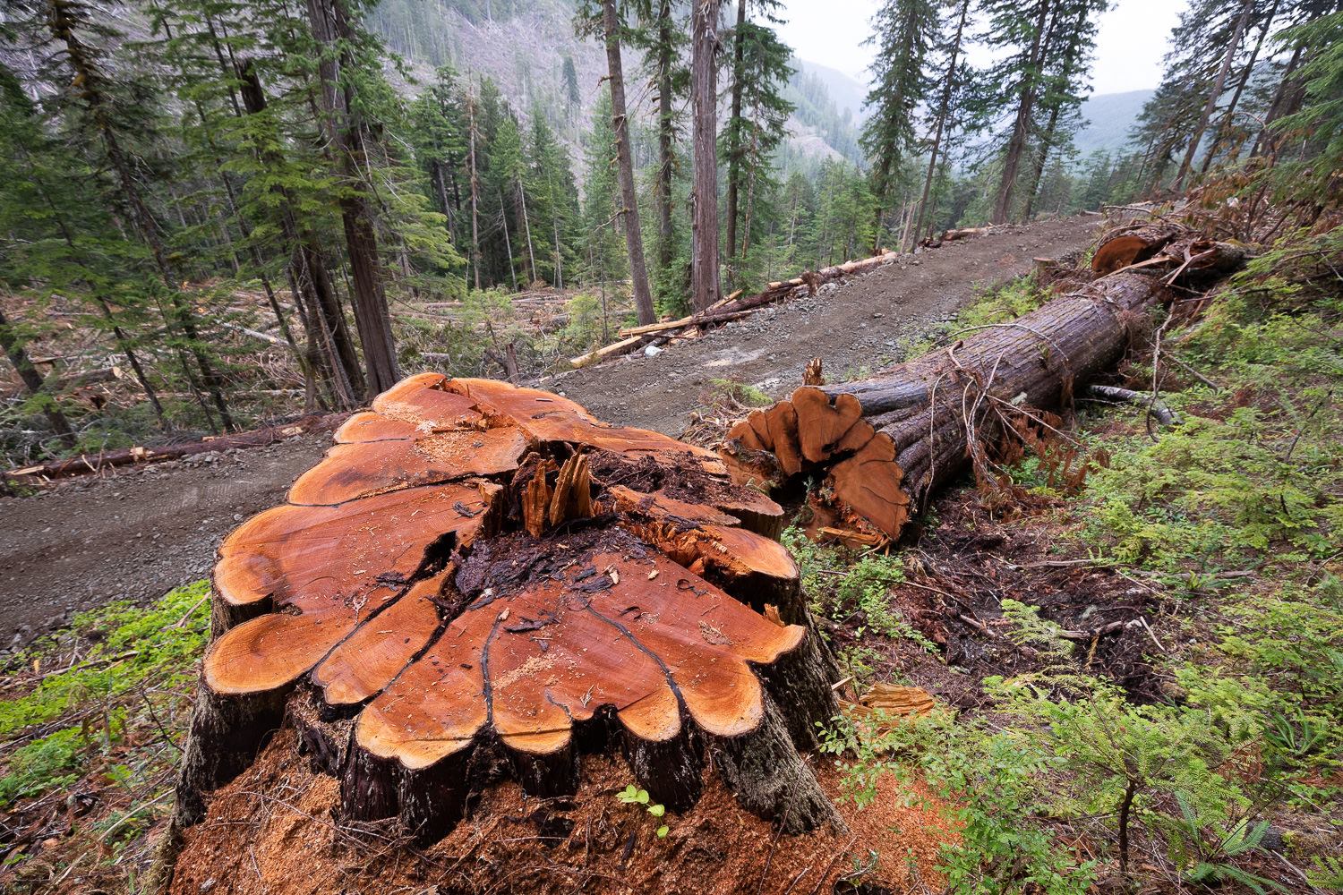
The National Forests system was originally set up by President Theodore Roosevelt to protect forests from commercial activity – not log them. Compromises made by Gifford Pinchot, the first Chief of the Forest Service, resulted in mining companies (and later timber companies) gaining access to our National Forests. In the early 1900’s, almost no one could imagine that the seemingly limitless supply of virgin timber on private lands would one day be exhausted. They could not conceive that in a few generations’ time, timber companies and their partners in government agencies would be fighting tooth and nail to log the dwindling amount of old growth in our national forests – our collective natural heritage.
Lessons for the Elliott Mr. Wuerthner’s impassioned writing has left me wondering what lessons future generations will glean from the current process surrounding the Elliott State Forest (likely to be handed over to OSU with their timber-centric “research design” in the coming weeks). How will they see the unusually short public outreach/comment period and the rush to complete the OSU plan in time for the Land Board’s approval? How will they judge our mainstream environmental groups who seem afraid to openly criticize the egregious shortcomings of the plan and process? Will future Oregonians accept that compromise was the best we could hope for with the Elliott State Forest?
Insight from the Advisory Committee: In a recent email, Bob Sallinger (Portland Audubon member serving on the Advisory Committee) clarified the current situation with OSU’s draft plan for the Elliott:
“The draft plan calls for cutting up to 3287 acres of mature forest (between 65 and 152 years of age) over a period of a couple or two decades using selective harvest (20%-80% retention). Several hundred acres within this 3287 acres are on the younger side (65-100 years old) but the majority is in 100-152 year range…
I don’t think there is anybody in the conservation community that thinks it is a good idea to cut these older stands or that the research benefits outweigh the benefits of preserving 100% of the older stands…Ultimately the question the conservation community will need to decide is whether they can live with the tradeoffs in this plan…
Pretty much 100% of the changes and concessions over the past year have been made to address conservation concerns. Despite that fact, if conservation interests sign-off, it looks like we will have consensus among all stakeholders including tribes, timber, counties, hunters and rec, and schools…
So bottom line is that there are definitely tradeoffs in this plan. There would be under any management scenario. In a perfect world we would lock up the entire Elliott as a carbon/ biodiversity reserve. However the same issues that have necessitated a decades long battle over the Elliott are still in play today.
Folks will have to decide whether the inclusion of things like clearcuts in about 14,000 acres of existing plantations (under 65 years of age) or selective harvest in a limited number of stands >65 are deal breakers or not. In doing so, I would encourage folks to think carefully about the other pathways that are available to us.“
I have great respect for Bob. He has been a true conservation hero on the Advisory Committee. But the 12-member committee was compromised at the outset by the inclusion of hardliners with vested economic interests (Douglas County Commissioner Chris Boice is a great example). When Bob writes about the need to live with tradeoffs and reach consensus among all stakeholders, I wonder what happened to the broader group of stakeholders – the citizens of Oregon. I also wonder why experts in forest ecology and carbon were not included on the committee – while timber interests were.
When it comes to the fate of the Elliott, surveys show Oregonians overwhelmingly support conservation. When I see DSL and the Land Board showing such great deference to OSU, I wonder, “Where’s the deference to Oregonians?” When it comes to this state forest, one ought to defer to the citizens of this state. And when it comes to compromise and tradeoffs, one has only to look at the millions of acres of clearcuts in our state and federal forests to understand that we’ve already compromised our natural heritage.
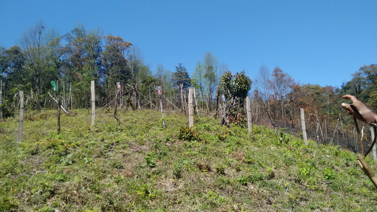
Pictures Tell the Story: OSU’s latest draft plan for the Elliott State Research Forest (ESRF) is an unwieldy mix of contradictions, obfuscation, and technical jargon put together by folks who clearly are not adept at communicating with a broader audience. When it comes to understanding this fundamental issue of compromise in the Elliott, pictures are the key.
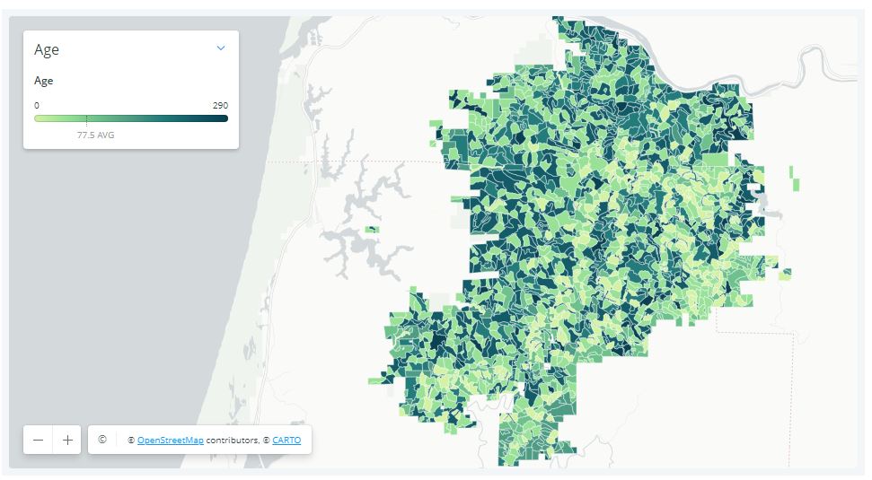
The map below shows the locations of older trees (indicated by darker shades of green) in the Elliott State Forest. It is important to note that significant quantities of older trees are scattered across vast stretches of the Forest.
Tree age classes in the Elliott State Forest (darker = older)
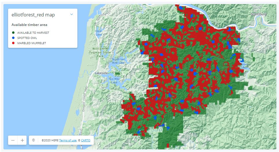
This next map shows the habitat of threatened birds (marbled murrelet in red and northern spotted owls in blue) in the Elliott. Predictably, the habitat is closely aligned with the older stands.
Habitat for threatened birds in the Elliott State Forest
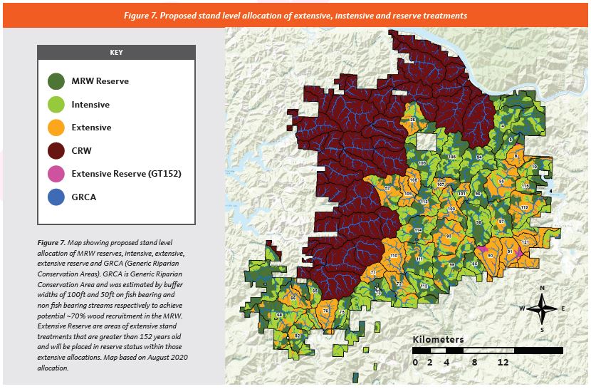
This final map shows how the OSU would divide the forest. The purple areas (denoted as “CRW”) would be “conservation research watersheds”, with limited logging allowed. The dark green areas (labeled as “MRW Reserve”) will be subject to experimental treatments (= logging) in the coming decades. The orange areas (labeled “Extensive”) will undergo thinning in which 20-80% of the trees are to be cut (including thousands of acres of older trees). The light green areas (labeled “Intensive”) are composed of trees less than 65 years of age, and will be subject to clearcutting.
OSU’s research design for the Elliott would perpetuate clearcutting or fragmentation in well over half the forest (conservation reserves shown in purple)
Viewed from the perspective of older trees and habit for our threatened birds, OSU’s plan for the Elliott is a complete disconnect. As the maps clearly show, it would sacrifice a majority of the Forest to continued clearcutting and fragmentation.
George Wuerthner’s eloquent words could not be more applicable to the Elliott:
“In far too many cases, there is a tendency to believe that it is necessary to appease local interests typically by agreeing to weakened protections or resource giveaways to garner the required political support for a successful conservation effort. However, this fails to consider that in nearly all cases where effective protective measures are enacted, it has been done over almost uniform local opposition.
In those instances where local opposition to a conservation measure is mild or does not exist, it probably means the proposal will be ineffective or worse—even set real conservation backward…Nevertheless, many environmentalists now believe that due to regional parochialism and lack of historical context, significant compromises are necessary to win approval for new conservation initiatives.“
The Elliott State Forest has already been heavily compromised – OSU’s plan would perpetuate the mistakes of the past.
The essence of OSU’s plan for the Elliott – the area on the west side would be protected, the area to the east would face continued fragmentation via a complicated matrix of “forest management” (including ~14,000 acres of clearcutting).
Five thousand acres of cloud forest are currently being threatened in Coatepec, Veracruz, Mexico. This land is, at present, being held by squatters, who, with the backing of local politicians, have claimed to be the forest’s rightful owners. They displaced dozens of families and are threatening one of Mexico’s most vital ecosystems. These 5,000 acres of land contain three municipal parks and one archeological site. While the land’s original stewards and forest protectors are engaged in a legal battle with the “invaders,” the deforestation of this fragile ecosystem has already commenced. This act of environmental devastation has wide political/economic ramifications. If you control Coatepec’s mountains, you control the subsistence and livelihood of millions.
The Coatepec Cloud Forest
The cloud forest above Coatepec is known as “la fabrica de agua” (the water factory). It is one of the last “water factories” of its kind in Mexico, and it moderates the weather of the entire region. The clouds that roll in from the Gulf of Mexico are captured by the forest canopy, the moisture forming a thick mist that shrouds the mountainside. Trees, moss, and orchids collaborate in an infinitely diverse ecosystem to retain the water that feed the region’s rivers, bringing life to the valleys bellow. The cities of Coatepec, Xalapa, and Cardel rely on this water, not to mention most of the communities of central Veracruz.
Globally, cloud forests are bastions of biodiversity. They harbor animal, and plant that are threatened by the shifting tides of the climate crises and uncontrolled land use. Coatepec’s cloud forest now hosts 90 plant, animal, and fungal species on the verge of extinction. Coupled with the biodiversity loss, the destruction of this ecosystem holds serious repercussions for the entire watershed. Without the cloud forest, the rivers will run dry, and the entire region will see considerably less rainfall. In short, the destruction of the cloud forest will spell drought and devastation for all.
The Invasion
In January 2019, a faction of the “Central Independiente de Obreros Agrícolas y Campesinos” (The Independent Organization of Agricultural Laborers and Farmers) set up an encampment on the 2,000 acres of cloud forest known as the Jinicuil Manso estate. CIOAC verbally threatened more than 500 original stewards of the land and claimed to be the legal owner of the property. While the information is difficult to corroborate, local activist networks say that the organizers of the CIOAC encampment came from outside the region, and do not hold legal rights to the said property. The community members who own land in the Jinicuil Manso estate submitted complaints to the local authorities. While the government “invited” the squatters to move off the premises, they requested that the community members refrain from engaging directly with CIOAC, to prevent physical aggression.
The situation was further complicated in February 2020, when the local authorities issued a “measurement and demarcation notice,” requesting that all the landowners submit paperwork confirming their title to the land. Many of the land’s stewards were not aware of the government’s decree. Others did not have the paperwork to prove that they owned their properties, even though the land had been in their family for generations. The local government never specified the reasons for this “demarcation notice,” and never compared the documents submitted by the land’s stewards with those provided by CIOAC. Instead, they refused to consider the documents submitted, and appear to favor CIOAC’s land claim, a land claim that local activists argue has been falsified.
The Electoral Politics of Water and Land
The local community groups, such as “Por la Defensa de la Sierra de Coatepec,” and the individual landowners, are currently involved in court cases with CIOAC. Throughout the process, it has it became clear the larger political forces are involved in the illegal “settlement” of the cloud forest. The CIOAC members have direct connection with major political parties in the area, with whom they have garnered ample political support. In addition, they have publicly thanked the governor of the State of Veracruz, Cuitlahuac García Jiménez, for his backing (though it is unclear whether this was just political posturing on the part of CIOAC).
Land, environmental destruction, and electoral politics has been devastatingly intertwined in Mexico for decades. When CIOAC first “invaded” the cloud forest, they invited citizens from the surrounding regions to squat on the appropriated land. Community members who did not own land of their own, and/or were seeking greater financial stability, settled in the cloud forest. Forest protectors have observed between 100 to 300 community members in the encampments at a time. They cut down trees, hunt the local fauna, and set up their septic systems to run off into the precious streams. When forest protectors attempt to plant trees or talk with the squatters, the squatters respond violently. They have been known to brandish guns and machetes, defending the land that has been promised to them.
Political figures from various parties in the region have sought to partner with the CIOAC settlers, nurturing a solid voting block of support. Leading up to the future regional and national elections, the ruling political parties have reacted favorably to the CIOAC’s land claims. However, underneath the surface, the forest protectors and activists claim that there is an even darker story. The people that live in the encampments of Jinicuil Manso could also be serving as a human shield, emptying the land for a larger economic interest that seeks to control the most vital resource of all: water.
The Conquest of the Cloud Forest
While at first glance the squatters could appear to be land hungry farmers, they are in fact just a cog in the virulent political system. Local activists believe that the squatters could be a facade for a political and economic interest that seeks to take over the forest of the region. Nestle, Coca-Cola, and other international corporations have huge factories in Coatepec, and have been seeking to control the region’s water supply for decades. Over the last series of elections, the community members have seen this same political/environmental ploy play out, though not to this level of devastation.
Veracruz is one the deadliest regions for land and water protectors in the world. “Por la Defensa de la Sierra de Coatepec” continues to organize throughout the region, raising awareness about the plight of the cloud forest, and the people that have been displaced. However, the settlers began threatening the lives of the forest protectors. When the organizers tried to negotiate with them in person, they were attacked with machetes. In the end, the CIAOC managed to scare most of the forest protectors into silence by actively threatening their families, while local authorities have turned a blind eye.
Action
While many forest protectors are too afraid to speak in public or to the press, the fight is not over. On the 29th of November 2020, “Por la Defensa de la Sierra de Coatepec” will return to the stolen land to begin reforesting the trees that have been cut down. They will also initiate a barter market with the local community members who have been directly affected by the theft of land. While many forest protectors have been forced to move to surrounding cities to protect their families, they are willing to risk their lives to defend and bring life back to the cloud forest.
Fairy Creek Blockade: defending old growth forests on unceded Pacheedaht territory
by Reuben Garbanzo, on Lekwungen territory
Joshua Wright, is a seventeen year old film-maker from Olympia, Washington with an irrepressible passion for protecting the last remaining old-growth temperate rainforests; and has handy access to a state-of-the-art digital mapping program that allows him to track and monitor industrial logging activities in near-real time. In early August, this year, he gave heads up to Vancouver island grassroots forest activists to a road-building crew subcontracted to Surrey-based tenure-holder of TFL 46, Teal Jones, cresting the ridge into the old-growth Yellow Cedar headwaters of Ada’itsx/ Fairy Creek watershed, the last unlogged tributary of the San Juan River system, unceded Pacheedaht territory, near Port Renfrew.
Forest firefighter Will O’Connell surveyed the road-building operation with spell-binding drone footage that captured earth-moving machinery operating on dangerously steep terrain pushing into a watershed never before logged, with no current cutblocks approved, but nonetheless heightening the risk of logging plan approvals, once the investment of road infrastructure had been established. This bold expose of a logging road incursion into one of the last roadless places on southern Vancouver island rapidly spread on social media and in the midst of a pandemic, galvanized forest defenders into non-violent direct action.
On Sunday, August 9th, twenty ancient forest activists from all over the south island, including the nearby communities of Port Renfrew and Cowichan valley, gathered at Lizard Lake and decided to set up a road blockade above the clouds 1000 metres up a treacherous logging road on a steep ridge overlooking the Gordon river valley, on the western flank of Fairy creek, where road-building into the Fairy, was slated the next work day. Tents were set up under the giant bucket of a gargantuan excavator and a 10′ diameter cedar log round from an ancient tree felled in the Klanawa Valley, propped vertically on a plywood frame, was installed as a barricade centrepiece across the road. When the Stone Pacific road crew arrived in darkness at 5 am the next morning they were politely confronted by a dozen people putting on the morning coffee around a small fire on the road end, with the intention of protecting Fairy Creek from road incursion.
Two weeks later another blockade was set up to protect the watershed on its eastern flank and to stop clearcut logging in an area of contiguous ancient forest that is part of the 5100 acre Fairy Creek rainforest, much of which is already under Old-Growth Management and Wildlife Habitat Area designation.
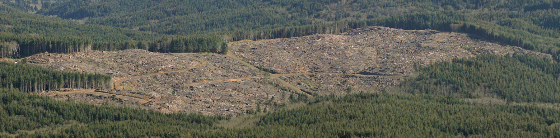
Pop-up blockades disrupting business as usual in other remnant old-growth forest locales have also sent a message to government and industry that in a down-spiraling climate and biodiversity crisis, disruption to the status quo is to be expected until the government takes decisive action to protect what is left of these globally significant and irreplaceable forests. The objectives/demands of all these blockade actions is to protect the last 1-3% of low-elevation old-growth rainforests left standing on so-called Vancouver island.
The Ada’itsx/Fairy Creek blockades are now entering their fourth month with no logging or road-building behind the barricades and no injunctions or arrests. This blockade, now the longest land-based direct action campaign on this island in over two decades has evolved quickly into a decentralized grassroots direct action movement under the banner of oldgrowthblockade, aimed to stem the tide of the colossal destruction of the shocking equivalent of 32 soccer fields of old-growth forests per day on the island alone.
Winterized infrastructure has been built at the main Fairy Creek base Camp, 7 kilometres off the the Pacific Marine Rd. including wood-heated Elder and Indigenous Warriors’ tents, bear-proof kitchen arbour, tool shed and hot water shower and change room. Dozens of volunteers communicating via several online platforms have provided coordination and mobilized material support to the frontlines which have been steadily maintained by a gritty, dedicated crew of core forest defenders, young and not so young, mostly women, who provide daily logistical coordination, elder care, leadership, hosting and reconnaissance on the ground.
This settler-Indigenous blockade has been blessed with the support and wise leadership of Pacheedaht elder Bill Jones who has asked that the entire valley, part of his childhood stomping ground, be dedicated as an Indigenous Protected Area in honour of the victims of the smallpox epidemic. Pacheedaht Chief and council have not responded for or against the blockade. The area is in the electoral riding of Premier John Horgan who has himself yet to respond to the demands of the blockade to protect Fairy Creek rainforest and all remaining old-growth temperate rainforests on the island.
On September 29th, the blockade received a strong statement of support from the Union of British Columbia Chiefs (UBCIC) who issued a breakthrough resolution calling on the Province to implement all 14 recommendations of their Old-Growth Strategy Review report and for the immediate protection of key old-growth forest hotpsots including Fairy Creek. Most significantly, their resolution called for government to assume responsibility in invesment in supporting First Nations to break free from the economic dependency on the old-growth forest destruction of their land-base, a major policy piece in the transition away from the destructive legacy of old-growth logging, once and for all.
August 1st : Discovery of Stone Pacific ( subcontracting to Teal Jones) road construction cresting the Ridge into the unlogged Fairy Creek headwaters
August 9: Grassroots activists from across Vancouver island meet at Lizard Lake and decide to erect an emergency logging road blockade at the end of Reid mainline, on a high ridge on the western side of Fairy Creek headwater, to prevent cutting, bulldozing and blasting activity into Fairy Creek the very next day. Notice is sent to Pacheedhat Chief and Council and Elder Bill Jones of setter-activist intentions to block road-building operations on their unceded territory.
August 10:Ridge camp blockade turns away Stone Pacific road and falling crews. Call out to request people to attend camp to defend against logging road construction into the last unlogged watershed in the San Juan River system.
August 17th: 2nd blockade at River Camp is established at another road access point into Fairy Creek along Granite mainline in the Renfrew Creek watershed, on the east side of Fairy Creek.
August 24th: a temporary, pop-up blockade is set up on Braden Mainline aimed at halting road-building and logging of old-growth forests on Edinburgh mountain, across from Fairy Creek in the San Juan river basin.
August 31st: Ridge camp blockade is moved 7kms down the road to a new blockade location aimed at halting road-construction into Fairy Creek and logging of contiguous old-growth forest adjacent to the Fairy Creek watershed.
September 4: Pacheedaht elder Bill Jones releases an official letter of invitation to Indigenous and non-Indigenous forest defenders to unite on the territory to defend the old-growth rainforests on his ancestral lands. An Elder’s tent is built at River Camp, where the elder has been staying overnight.
September 6: A caravan of Indigenous youth and elders, from many territories visit the blockades to further advise on appropriate respect protocols for forest defenders taking action on the land. 📷
September 22: The blockade camp on Reid main is moved back to its original position at the top of the Ridge at the end of Reid main. More Pacheedaht community members visit the blockades.
October 3: Northview Timber pulls road-building machinery off the mountain, abandoning plans to push roads through into Fairy Creek, past Ridge Camp, until after winter. Ridge camp remains for monitoring. Winterization of River camp continues, including bear-proof communal kitchen shelter, wood-heated communal tents, tool shed and a hot water shower.
October 22: An exploratory trail is cut from the Ridge camp along the Ridge to a lookout point above Ada’itsx/Fairy Creek with a group of Indigenous youth.
October 25: A sacred fire is lit at River Camp by Indigenous elders, youth and matriarchs, for prayer and ceremony, supporting the blockade, the forest and forest protectors.
November 9: Pop-up blockade is established at Grierson main to protect rare valley bottom ancient rainforest from road-building into Camper Creek headwaters.
The survival of several uncontacted tribes is now at risk after fires were set inside their territories. Activists have described this year’s Amazon fires, and President Bolsonaro’s war on indigenous peoples, as “the gravest threat to the survival of uncontacted tribes for a generation.”
Four tribal territories face an especially serious crisis:
– The famed Papaya Forest on Bananal Island, the world’s largest fluvial island. It’s inhabited by uncontacted Ãwa people. Eighty per cent of the forest burned in fires last year – fires have been seen this year in one of the last areas of intact forest. More than 100,000 head of cattle now graze on the island.
– The Ituna Itatá (“Smell of Fire”) indigenous territory in Pará state, inhabited exclusively by uncontacted Indians. This reserve was the most heavily deforested indigenous territory in 2019, as land grabbers and cattle ranchers invaded. In the first four months of 2020, another 1,319 hectares of forest were destroyed, an increase of almost 60% compared to the same period last year.
– The Arariboia territory in the eastern Amazon state of Maranhão: uncontacted Awá inhabit this territory, which has already been extensively invaded. Amazon Guardians of the neighboring Guajajara tribe are warning daily that illegal loggers are destroying the forest at alarming rates. (The Ãwa people of Bananal Island and the Awá tribe of Maranhão state are distinct peoples).
– The Uru Eu Wau Wau territory. Uncontacted Indians inside this territory shot and killed famed Amazon expert Rieli Franciscato last month – campaigners fear the group is being forced out of the forest by the invasions.
Many of the fires are being started to clear the rainforest for logging and ranching, and millions of tons of soya, beef, timber and other products are imported into Europe and the US each year.
APIB (the Association of Indigenous Peoples of Brazil) has launched a campaign to highlight the links between Bolsonaro, his agribusiness backers, and the genocidal violence being committed against indigenous peoples across the country. They are asking people and companies around the world to stop buying products that are fuelling the destruction of their territories.
Survival has launched a global action calling on supermarkets in Europe and the US to stop buying Brazilian agribusiness products until indigenous rights are upheld.
Ângela Kaxuyana, spokesperson from COIAB, the Coordination of Indigenous Organizations of the Brazilian Amazon, said: “Land grabbing, deforestation and arson directly threaten the lives of our uncontacted relatives. The destruction of the territories that are their only sources of life, from where they obtain their food (fauna, flora and water), could end in their extermination.” “A grilagem de terra, o desmatamento e os incêndios criminosos ameaçam diretamente a vida dos nossos parentes em isolamento voluntário. A destruição dos territórios que são suas únicas fontes de vida, de onde garantem sua alimentação (fauna, flora e água), podem levá-los ao extermínio”.
Tainaky Tenetehar, one of the Guajajara Guardians who protect the Arariboia reserve for the Guajajara people and their uncontacted neighbors, said today: “We fight to protect this forest, and many of us have been killed doing so, but the invaders keep coming. They have damaged the forest so much in recent years that their fires are now much bigger, and more serious, than before, as the forest is so dry and vulnerable. The loggers must be evicted – only then can the uncontacted Awá survive and thrive.”
Survival’s Senior Researcher Sarah Shenker said: “In many parts of Brazil, uncontacted tribes’ territories are the last significant areas of rainforest left. Now they are being targeted by land grabbers, loggers and ranchers emboldened by Bolsonaro’s open support for them. Consumers in the US and Europe must understand that there’s a direct connection between the food on their supermarket shelves and this genocidal destruction – and act accordingly. Uncontacted tribes are the most vulnerable peoples on the planet, and at the same time nature’s best guardians, by far. We cannot let their land go up in flames.”
The Capitol State Forest, Washington — Early Wednesday afternoon just as the fog melted off, a convoy of trucks from at least four different law enforcement agencies parked on a logging road for an unannounced raid on a camp of forest protection activists, sweeping the camp away and leaving one man in the forest canopy tied to a unique contraption that continues to impede work on the controversial “Chameleon” timber sale. The officers came from the Thurston County Sheriff’s Office, the Washington State Patrol, the state Fish and Game Department, and the Department of Natural Resources (DNR) which planned and sold the timber sale and oversees all of the Capitol State Forest. They temporarily closed the roads to through traffic while they cleared the activists from the camp.
Ian Frederick, 29, a teacher from Olympia, was on the ground making coffee when the cops arrived. “There were just so many of them,” he said. “It seems like a lot of force to bring to deal with two unarmed civilians eating lunch.”
The two activists were briefly detained before being allowed to walk away while the officers attempted to negotiate with the remaining “tree-sitter” who continued to block the logging road. The DNR law enforcement eventually brought in spotlights and a generator and began to prepare for a siege of the tree-sit.
The man in the treesit was John “Tree’Angelo” Barksdale. Mr. Barksdale, 34, an outdoor educator from Tumwater, has watched with dismay over the past several years as the DNR has systematically clear-cut most of its remaining old-growth stands. An avid hiker, he’s seen many of his favorite local trails turned to moonscapes.
“Unit 1 of Chameleon is some of the most intact forest, the best habitat left across one hundred thousand acres,” Mr. Barksdale said. “If we want all this to actually be a forest and not just an oversized tree plantation, we need to save at least something. We can’t clear-cut all of it.”
Mr. Barksdale has used years of climbing experience to erect a unique “dunk-tank” platform atop an old-growth douglas-fir tree, tied to an abandoned Ford Explorer parked across the proposed logging road. If the car moves, his platform drops. It’s about one hundred feet down to the steep slopes of the forest below. Mr. Barksdale claims to have plenty of food and water and says he is prepared to wait out the DNR indefinitely.
“I’ve always wanted to tree-sit,” he says. “I love trees. I love camping. I can work remotely out here and attend Zoom meetings from right here on the platform. It’s super dreamy up here, and I’m trying to save these trees. I can’t think of anything else I’d rather be doing.”
The protest camp, which was started ten days ago by a few friends of Mr. Barksdale, quickly picked up support from local hunters, fishermen and ATV users concerned about the health of the forest. Protectors of the Salish Sea, an indigenous water advocacy group, held space with songs and prayers at the blockade on Saturday. Multiple community groups across Thurston County have come out in support of the blockade and are calling for the cancellation of the timber sale.
The tree sit came to an end several days later when storms forced Mr. Barksdale to descend.
![[Old Growth Blockade] Old-Growth Blockade Enters Fourth Month](https://dgrnewsservice.org/wp-content/uploads/sites/18/2020/11/fairycreek.jpg)