Editor’s Note: The following is an update from Roam Free Nation on the bison “hunt” in Yellowstone National Park. You can find our original story here.
THE “HUNT”
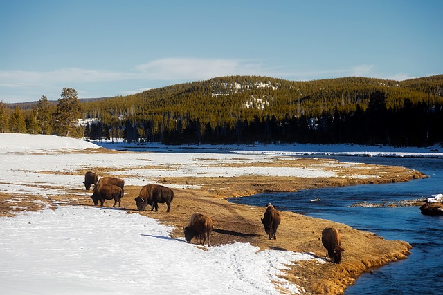
The Montana state bison “hunt” began on November 15. Eight bulls, from the imperiled Central herd, have already been killed by state hunters near West Yellowstone, in the Hebgen Basin. Yellowstone National Park has been warning against killing any buffalo in the Hebgen Basin for many years now, because the Central herd – the truly last wild, migratory buffalo – continues to decline.
The Central herd migrates both into the Hebgen Basin (to the west) and the Gardiner Basin (to the north), so they are doubly impacted by mismanagement actions. In the Gardiner Basin, both the Northern herd and Central herd move into harm’s way. But only the Central herd migrates into the Hebgen Basin, so by refraining from killing there, at least some Central herd buffalo are protected.
These warnings by the Park’s bison biologists continue to fall on the deaf ears of both state and treaty hunters. However, due to the continuing decline of the Central herd, Montana Fish, Wildlife & Parks are proposing to reduce the number of state licenses for next year from 40 to 25 in the Hebgen Basin. It’s still 25 too many, but it’s something.
Winter has been slow to arrive. West Yellowstone (Hebgen Basin) is just now starting to get some snow. It may be a mild winter this year, and if so, it could ease human-caused hardships on the buffalo. But, just as we need the snow so the rivers will be full in spring, the buffalo need to roam, to express themselves upon the earth and heal the wounded land.
MEDIA TRACTION
There’s been quite a flurry of activity in the past couple of weeks. Roam Free Nation joined with our allies, the Alliance for the Wild Rockies (AWR), Council for Wildlife and Fish, and the Gallatin Wildlife Association in sending a letter to Gallatin National Forest Supervisor Mary Erickson, urging her to close the Gardiner Basin’s Beattie Gulch (“the killing fields”) to buffalo hunting.
We raised concerns about the serious public safety issues, and of course the buffalo suffer at this bottleneck migration corridor on the northern edge of Yellowstone National Park. Ms. Erickson is the perfect bureaucrat who responded with policy jargon that avoided the issue entirely.
Shortly after that, the Montana-based Bozeman Daily Chronicle began a poll asking if Beattie Gulch should be closed to buffalo hunting. We sent out a last-minute alert and so many of you responded! Thank you! As of this writing, the poll is still open to voting – so visit this link and make your voice herd now! The “yes” votes were up to 80.2% in favor of closing Beattie Gulch!
As all of this was taking place, our strong allies at AWR and Council for Wildlife and Fish, like last year, got some billboards in the works! They used Roam Free Nation’s image of a mom and baby buffalo, with the message: “Save Yellowstone Buffalo. Stop Buffalo Genocide.” There is currently a billboard up in Billings, Montana, and soon to be one in Missoula. We give thanks for all the support from AWR and CWF!!
THE HARD TRUTH
Just the other day, our friend and ally, Steve Kelly, of Council for Wildlife and Fish had a really powerful column published, “Stop Buffalo Genocide and a Repeat of History“, representing our billboard and urging folks to contact Gallatin National Forest Supervisor Mary Erickson to close Beattie Gulch to buffalo “hunting”. You can take that action right now by emailing her at mary.erickson@usda.gov.
KEEP RFN IN THE FIELD!
Roam Free Nation will soon be heading into the field to monitor the situation and defend our relatives, the buffalo. We need your support, however you can offer it. We give thanks to you and all of our allies for standing up for the last wild buffalo!
Editor’s Note: For a long time, natural landscapes have been destroyed in the name of development. “Development” – a vague concept in itself – is the primary driver of destruction and ecocide across the world. Same thing is happening in the beautiful Gozo island of Malta. But it’s not happening without resistance. Some local groups are fighting for their land. This piece is written by a member of resistance against the development. In addition to the brief overview of the “developmental” project, this piece is also a fundraising appeal from the group.
By Corrine Zahra
Image by Freehour Malta
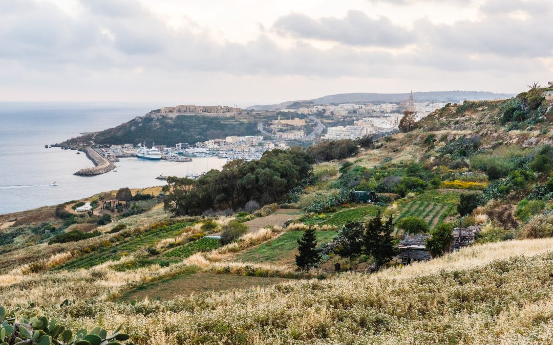
Malta is an archipelago country made up of five islands in the middle of the Mediterranean Sea. This country is rich in culture and history, with a native language and multiple dialects. Being such a small country with an area of about 316 km², overdevelopment is on the rise.
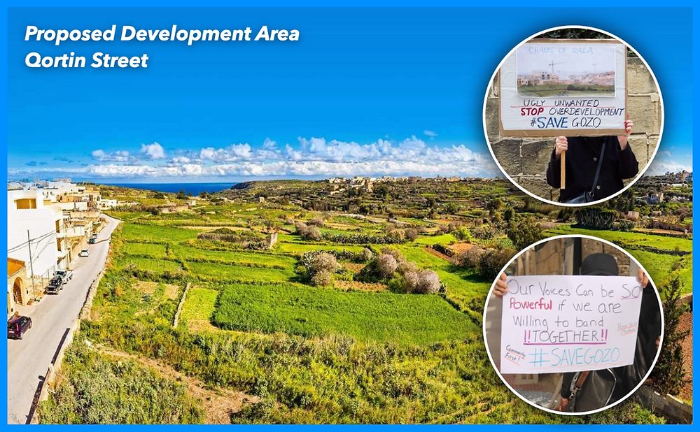
Residents from a small town called Nadur in Gozo are fighting against a development called PA/00085/21. Located in a one-way countryside road called Qortin Street, this major development was a big deal in the Maltese news since it consisted of 40 apartments and 11 penthouses – over four floors, as well as 61 parking spaces.
Gozo is a beautiful island that forms part of the Maltese Islands which is under threat. Unsustainable overdevelopment is taking place! The residents had created a video two years ago which helped them to collect objections from the public.
This proposal got approved a few months ago anyways, in which the residents as well as the NGOs Flimkien Ghal Ambjent Ahjar (Together for Better Environment) and Moviment Graffitti are now trying to take the Maltese Planning Authority to court to reverse this decision.
This development will eat away at precious farmland, causing sewage to run into farmers’ crops and the water table as well as causing massive parking issues, along with posing safety issues.
This development will completely change the landscape of the area. The street consists of small houses with a maximum of three stories each. Next door to the development, there currently exists a block of apartments yet only has 15 apartments in total – very few compared to the amount proposed by the applicant. Once the virgin land is destroyed, the view of Nadur and Qala will be destroyed too.
In the early mornings, while walking in my street, I can smell the freshness and feel the water droplets in the air. This countryside street full of vegetation and raw soil will be destroyed to build apartments which do not belong there. The number is out of proportion to the rest of the developments in the street. Qortin Street is a quiet street with few residents, yet with this new building, there will be a parking problem and a cultural shift as the buyers will not be people from Gozo but mainland Maltesers.
If this development does get built, I do plan to move away from Gozo. I do not want to see the development – I do not want my image of Qortin Street to change. It’s a shame that this development will change Gozitan culture – this is happening all over Gozo. I will gain nothing out of fighting for this land; I do not own any of the land which is going to be destroyed and I will not get any money out of this too. I simply want my street to remain calm and quiet and relaxing – I want to preserve the land and the peace of mind that it gives me.
The residents and NGOs had managed to get 1300+ objections, yet in spite of this, PA/00085/21 was still approved. However, they are still fighting and now they need YOUR help!
The residents created another video to help get local donations yet are now trying to reach out to international organizations to help their cause. Kindly find their crowdfunding video here.
They hope that you can help their cause to stop this monstrosity of a development from being built. Help save Malta and Gozo from overdevelopment. No one wants Malta to turn into a concrete jungle – this has already started and they want to prevent that.
It is imperative that citizens enjoy their right to a good quality of life, preserving the countryside and iconic views for future generations.
Please help the residents appeal through the EPRT and if necessary through the Courts of Appeal, by donating here.
All donations will cover the costs of their legal team who have already done incredible work in fighting this case at the Planning Authority, but now they need your help to continue to fight this case in court.
Editor’s note: The Ambler road is being planned in Alaska to connect the Dalton Highway with the Ambler Mining District. It will cross the Arctic National Park, state lands and native lands. The road in itself poses many threats to the wildlife which is described in the following piece. Many stakeholders are involved in this project, some of them support it and some of them oppose it. Proponents include the Congressional delegates from Alaska and native tribes who hope to benefit from the added jobs in their economy. Those who oppose it are the native groups whose subsistence hunting and gathering is threatened by the road and conservationists.
As George Wuerthner mentions in this piece, for a long time, the mining project was not feasible economically, and thus the area was protected from extraction. As we are extracting the last remaining fossil fuels, mining sites like these, which were too expensive in the past, become more necessary for the so called energy transition. We can expect this trend to grow in the future. As fossil fuels peak, there will be more and more extraction of these last remaining pockets of minerals. This mining prospect in Alaska is just another example of this.
While much conservation and political attention have focused on whether to allow oil development in the Arctic National Wildlife Refuge, another project, the Ambler Mining Project, and road construction proposal may pose even greater threats to the Arctic’s wildlife and wildlands. Despite this threat, The Ambler project has thus far received far less attention from the media, politicians and conservation organizations.
The proposed 211-mile Ambler Road would connect the Dalton Highway (pipeline haul road) with the Ambler Mining District in the western Brooks Range. The ore belt that stretches for 200 miles contains copper, cobalt, lead, and zinc and could be one of the most valuable deposits in the world, especially as people turn to electric vehicles.
There is new interest in encouraging the US development of critical minerals and energy, and the Ambler Mining proposal benefits from this push for US sources of minerals.
Although these deposits have been well-known for decades, the cost of mining, smelting, and transportation has precluded development. (I knew about the ore deposits in the 1970s when I lived and worked along the Kobuk River).
Years ago, I taught a class on Alaskan Environmental Politics. I emphasized that Alaska has more oil, coal, minerals, and even forests than most other parts of the United States. Many of these resources remain undeveloped because of the harsh climate, remote locations, and lack of access.
There are, for instance, substantial forest resources in Southeast Alaska. Still, they cannot be cut and transported without government subsidies because it’s cheaper to log trees in Oregon or Washington.
The Prudhoe Bay oil fields were the world’s 10th most significant oil reserves, and the other nine were in the Middle East. The Prudhoe Bay oil fields would have remained undeveloped had it not been for the construction of the Alaskan Oil Pipeline, which made these oil reserves economic to develop.
The Ambler Mineral deposits are considered “world-class.” Getting a road to the Ambler Deposits is the first step in making mining operations profitable. The Bureau of Land Managment (BLM) and the Corps of Engineers under the Trump Administration approved the road plan in 2020, and officials agreed to issue a 50-year right-of-way for the Alaska Industrial Development and Export Authority, the state public corporation working to develop the project.
However, the Biden Administration halted the road project while a Supplemental EIS process mandated by the courts was completed. However, my sources in Alaska suggest this may be for show. The comment period ended on November 4th, and the BLM review will likely be published sometime in the new year.
If you want to understand politics, all you have to do is follow the money.
The mining claims are owned mainly by local Iñupiat people living in NW Alaska coast and inland along the Kobuk River, represented by NANA corporation. They also operate the Red Dog Zinc mine, one of Alaska’s most significant mining and polluted sites.
During the land selection process created by the Alaska Native Claims Settlement Act (ANCSA), native people targeted the lands with valuable known mineralization or fossil fuel resources.
In the case of the Ambler mines, NANA shareholders are likely to be employed during road construction and mining operations.
One study estimates that 20% of all construction jobs will be held by local villagers, providing significant money input into these rural villages. NANA corporate leaders likely believe they are working in the best interests of their constituency.
In addition to NANA and some residents who would benefit from jobs and royalty payments, the road is also supported by the state of Alaska. The Alaska Industrial Development and Export Authority (AIDEA) would own Ambler Road.
Alaska’s Congressional Delegation, including newly elected half-Native Democrat Mary Peltrola and Republican Senator Lisa Murkowski, support the road and mining proposal. Peltrola has also joined her Republican counterparts in the Senate to support oil development in the Naval Petroleum Reserve.
The road, if built, would likely lead to road sprawl and the expansion of development in the region, including perhaps oil development in the Naval Petroleum Reserve to the north of the Brooks Range.
Although the supporters point out that the road would be a private road only accessible to industrial use, opponents point out that the same claim was made about the Pipeline Haul Road. However, in 1994 the state opened the Pipeline Road (Dalton Highway) for unrestricted, public use.
Opposition to the road comes from Tanana Chiefs and other Athabascan Indians living along the Koyukuk River and tributaries. The Athabascan would gain no advantage to a road except perhaps for more accessible and cheaper shipment of supplies. But they fear the road would disrupt subsistence hunting and gathering.
The Athabascans are not necessarily opposed to mining or oil development themselves. Doyon Native Corporation, which represents the Athabascan people of the Yukon Basin, during the land selection process of the Alaskan Native Claims Settlement Act has specifically targeted mineralized lands. Today, they have several active mining operations. However, Doyon has neither endorsed or opposed the Ambler Road and mining projects.
However, Doyon has proposed alternative road access to the Ambler district from Nome.
So, in essence, the road is pitting one ethnic native group against another.
In addition to opposition from some native people, many conservationists also oppose the road. The Ambler Road, if built, would cross the Gates of the Arctic National Park and Preserve and numerous other protected areas like the Kobuk Wild and Scenic Rivers.
The National Park Service did an excellent review of the potential impacts of the road on wetlands, water quality, fish, wildlife, subsistence, and recreational impacts on the park that applies to the total road mileage.
Conservationists and native people opposed to the mine have produced a good video about how the road would impact the Arctic:
An environmental review by the BLM in 2020 found that the road would impact salmon, caribou, and other wildlife.
Roads can be semi-permeable barriers, and although crossing such obstacles is possible, caribou may shift or entirely abandon their seasonal habitat. The disturbance and activity along the road and mining operations are likely to affect caribou in other ways. Studies have shown that caribou may travel up to 9.3 miles to avoid roads and 11.2 miles to avoid settlements.
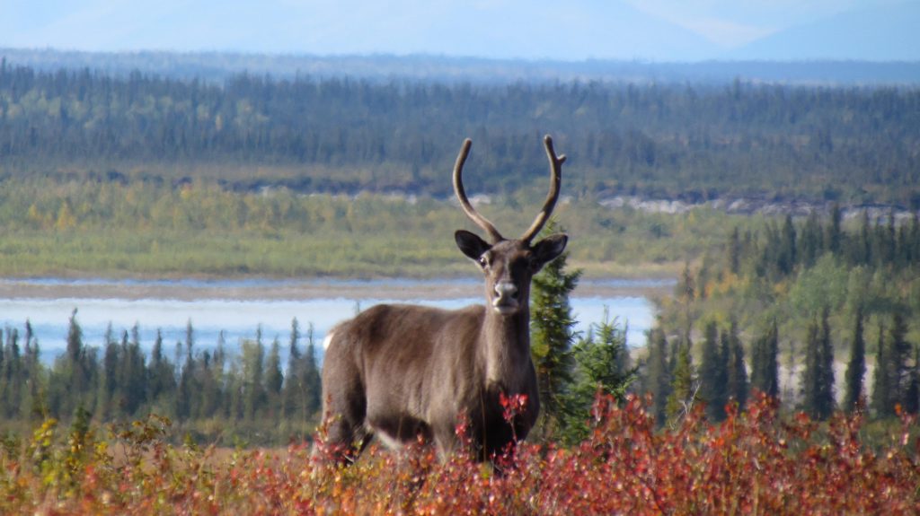
Thousands of caribou like this one traditionally cross the Kobuk River near Onion Portage in the fall. Accessibility statement: Single caribou looks directly at the camera surrounded by red shrubs, with river and forest in background.
For instance, a study of the Native-owned Red Dog Mine Industrial Access road north of Kotzebue found that just four vehicles an hour affected the migration of 30% of collared caribou, or approximately 72,000 individuals of the 2017 population estimates.
Linear features like roads also are used by predators like wolves. This can increase predator influence on prey like caribou. Roads and seismic lines in Alberta have led to increased predation on woodland caribou.
It also does not take much imagination to see that this road will eventually be extended to the coast by Kotzebue, fragmenting the entire western Brooks Range’s ecosystems.
Nevertheless, the road’s construction was approved by the Trump administration. However, the Biden Administration has ordered the Bureau of Land Management to reevaluate the Environmental Review.
The BLM accepted comments until November 4th. Whether the BLM review changes the decision to move forward with the road remains to be seen.
But my sources in Alaska say that the Biden Administration is likely to approve the road to help Alaskan politicians, perhaps with stricter regulations designed to address environmental concerns. The Biden Administration doesn’t want to oppose new Democratic Congressional Representative Mary Petrola who is a supporter of the mine road. Murkowsi was critical to Democrats in voting to convict Donald Trump for his role in the Jan. 6th insurrection, was one of three GOP to vote for nomination of Judge Ketanji Brown Jackson and she was the only GOP member to support the Voting Rights Bill. Biden does not want to alienate her potential support for other Democratic agenda votes.
I can’t emphasize enough that this road is one of the biggest threats to the Arctic’s wildlands and wildlife. It is bigger than just the development impacts that may result from the Ambler Mining operations. I have no doubts that the road, if built, will eventually make other mineral and oil, and gas sources economically viable to develop.
George Wuerthner is a professional photographer, writer, and ecologist. He has written more than three dozen books on natural history and other environmental topics. He is currently the Ed of Public Lands Media. Wuerthner has visited hundreds of mountain ranges around the West, more than 400 wilderness areas, more than 200 national park units, and every national forest west of the Mississippi. Listen to Derrick Jensen’s latest interview with George Wuerthner.
Editor’s Note: The following article compares civilization to a cult, by questioning some of the basic assumptions of civilization. Civilization, particularly industrial civilization, is fundamentally unsustainable. The solutions proposed to make it more sustainable, i.e. technological advancements, miss the root cause of the problem, i.e. overconsumption by a species to the detriment of all life forms on Earth.(more…)
Editor’s Note: Development projects have always destroyed local ways of living and nonhuman communities. Numerous examples attest to that. The government of Cambodia need not look very far. The Lower Sesan 2 dam it built despite resistance has collectively been decried by national and international organizations for numerous human rights and indigenous rights violations. The government of Cambodia itself placed a ten-year ban on damming Mekong in 2020. Despite this, the government has permitted the group responsible for Lower Sesan 2 to conduct geological studies for building the Stung Treng dam along Mekong river. Previous studies have already outlined the devastating effects it can have on the fisher communities.
It is no surprise that states prioritize profits over local communities in their decision making process. Organized political resistance is required for the local communities to stand a chance against such decisions that hughly impact their lives.
Cambodian authorities have greenlit studies for a major hydropower dam on the Mekong River in Stung Treng province, despite a ban on dam building on the river that’s been in place since 2020.
Plans for the 1,400-megawatt Stung Treng dam have been around since 2007, but the project, under various would-be developers, has repeatedly been shelved over criticism of its impacts.
This time around, the project is being championed by Royal Group, a politically connected conglomerate that was also behind the hugely controversial Lower Sesan 2 dam on a tributary of the Mekong, prompting fears among local communities and experts alike.
This story was supported by the Pulitzer Center’s Rainforest Investigations Network where Gerald Flynn is a fellow.
STUNG TRENG, Cambodia — A long-dormant plan to build a mega dam on the mainstream of the Mekong River in Cambodia’s northeastern Stung Treng province appears to have been revived this year, leaving locals immediately downstream of the potential sites worried and experts confounded.
First studied in 2007, the 1,400-megawatt hydropower project, known as the Stung Treng dam, has reared its head in many forms, only to be canceled or scrapped. Finally, in 2020, Cambodia’s government announced a 10-year ban on damming the Mekong River’s mainstream, placing the Stung Treng dam and others on indefinite life support.
However, on Dec. 29, 2021, Royal Group — arguably Cambodia’s largest and best-connected conglomerate — wrote to the government, requesting permission to conduct a six-month feasibility study across a number of sites along the Mekong in a bid to revive the long-sought-after hydropower project.
The Ministry of Mines and Energy approved, and Stung Treng Governor Svay Sam Eang ordered district governors to cooperate with SBK Research and Development, a Phnom Penh-based consultancy hired by Royal Group, while they analyzed three sites for the dam between January and June 2022.
All the sites that SBK analyzed sit within or would affect the Stung Treng Ramsar site, a wetland of ecological significance that’s supposed to be protected by the Ramsar Convention, an international treaty to which Cambodia became a signatory in 1999.
Spanning some 14,600 hectares (36,100 acres), the Stung Treng Ramsar site stretches 40 kilometers (25 miles) up from the confluence of the Mekong and Sekong rivers, almost to the Laos-Cambodia border. It’s home to the white-shouldered Ibis (Pseudibis davisoni) and giant Mekong catfish (Pangasianodon gigas), both critically endangered species, and the Irrawaddy dolphin (Orcaella brevirostris), which is globally endangered but whose Mekong population is considered critically endangered.
Sites analyzed by SBK Consultants for Royal Group’s Stung Treng dam. Map by Gerald Flynn/Mongabay.
The volleys of criticism that each study provoked has seen the Stung Treng dam shelved repeatedly. A 2012 study by the Cambodian Fisheries Administration’s Inland Fisheries Research and Development Institute found the Stung Treng dam would reduce aquatic food yields by 6% and 24% by 2030. This, the government’s own researchers warned, would lead to increased malnutrition and worse public health outcomes, especially among poorer, rural communities.
WWF’s Greater Mekong program then published an extensive brief in 2018 reiterating the threats posed by the Stung Treng dam to fisheries, agriculture, ecosystems and biodiversity.
By then, however, many of these fears had already been realized in the form of the Lower Sesan 2 hydropower dam.
Also located in Stung Treng province, roughly 30 km (19 mi) from the Ramsar site, the Lower Sesan 2 was approved in 2012 before going online in 2018 after a tumultuous series of studies throughout the 1990s. Following funding issues, Royal Group stepped in as a financier to save the project, but this didn’t stop the Lower Sesan 2 from rapidly becoming emblematic of the numerous problems associated with dams on the Mekong and its tributaries.
Even now, nearly four years after the dam’s completion, pro-government Cambodian and Chinese outlets continue attempting to resuscitate the Lower Sesan 2’s image, which was tarnished by the sheer scale of human suffering and environmental degradation it’s been linked to.
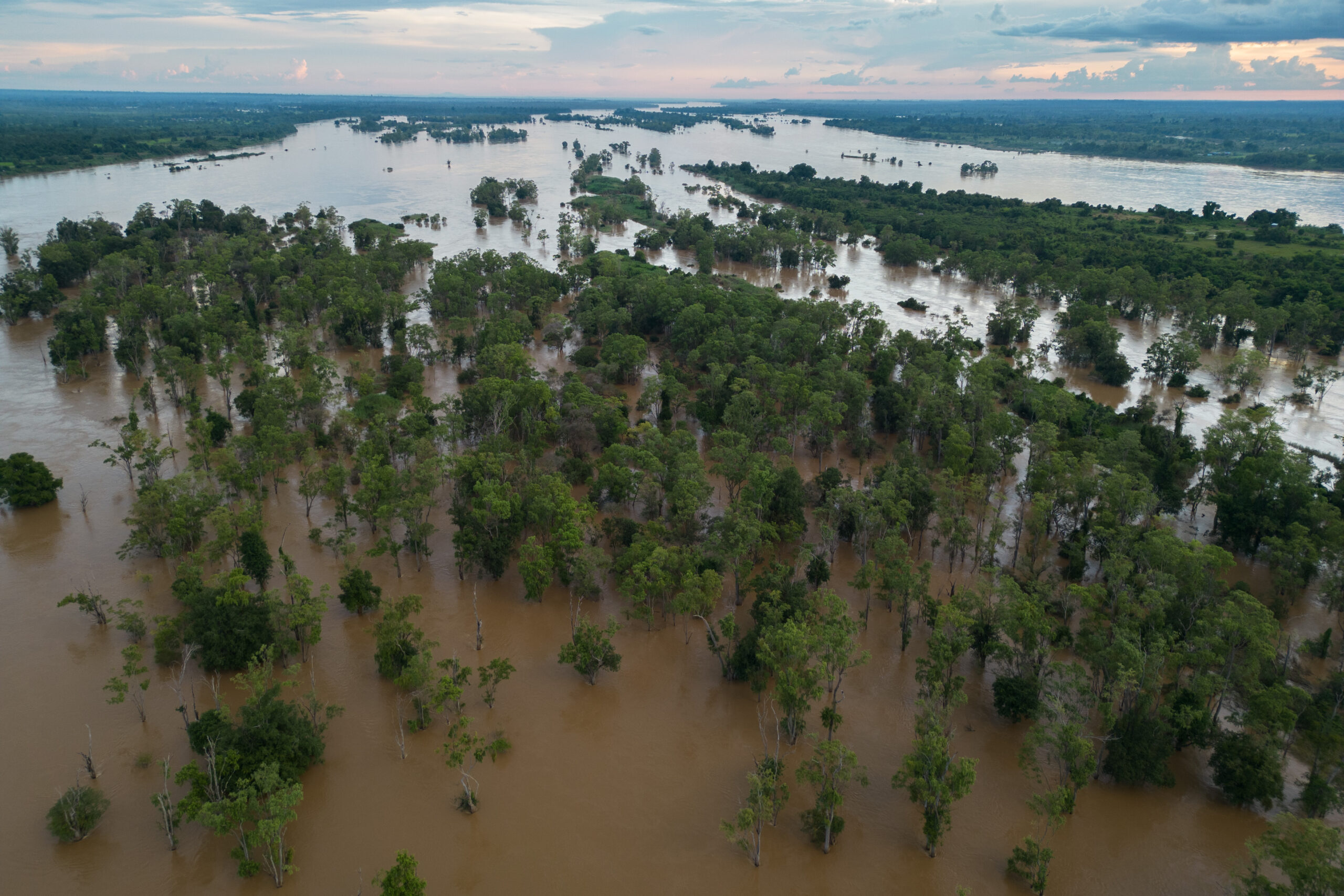
The Stung Treng Ramsar site could be compromised by Cambodia’s hydropower ambitions. Image by Gerald Flynn/Mongabay.
Royal Group maintains the dam is a success and says the project supplied 20% of Cambodia’s energy demands in 2020. But before the project was even finished, it came under fire from the United Nations, numerous NGOs both international and domestic, as well as thousands of affected residents displaced by the dam’s 30,000-hectare (74,000-acre) reservoir.
Since the dam’s completion, Human Rights Watch has branded the Lower Sesan 2 “a disaster” in a 137-page report released last year, calling the dam’s developers responsible for multiple human rights violations, abuses against Indigenous peoples, and a drastic decline in fisheries, along with failing to actually live up to its projected power generation targets.
Haunted by the Lower Sesan 2, the residents of the Stung Treng Ramsar site’s islands were deeply concerned when they saw SBK Research and Development engaged in geological studies and learned the prospect of the Stung Treng dam had returned again.
“The local authorities came round at the start of the year,” says Mao Sareth, chief of the Koh Khan Din fishing community in the south of the Stung Treng Ramsar site. “They told us they want to build a dam that’ll be 7 meters [23 feet] high and will affect 163 families — it’s going to be huge, 1,400 MW, that’s what they told me.”
Mao Sareth, chief of the Koh Khan Din fishing community in the south of the Stung Treng Ramsar site. Image by Nehru Pry/Mongabay.
Sareth is reluctant to discuss the details of the proposed dam, hinting that people have warned him against discussing the project with journalists. But for the 72-year-old, the number of families who would be affected if the Stung Treng dam goes ahead would be much higher than what SBK’s consultants suggested, although the consequences for each island would vary depending on whether the dam was built up or downstream of their community.
“There are 144 families in our village alone, with plenty more spread across the islands and there are hundreds of islands here, full of people who farm and fish,” Sareth says. “Of course we’d be affected if they build the dam, lots of communities would be flooded, everyone relies on agriculture here, the dam would destroy our crops.”
Already at the mercy of water released or withheld by dams upstream in Laos, Sareth says his community exists in a fragile balance, eking out an existence that hinges on access to fish from the water and crops nourished by it. The Stung Treng Ramsar site’s ecosystem, he says, has held the community together, with only seven families leaving last year to find day-laborer work in Thailand.
“Most people try to stay and find a new market for their crops,” Sareth says. “They can take food from the river — they can survive here.”
But Sareth is no stranger to defeat at the hands of hydropower developers, and knows that if the government decides to break its own ban on Mekong dam building, then it will be his community that suffers.
“We protested the Don Sahong dam in Laos because we knew it would hurt our people, our livelihoods, but our protests made no difference — they finished the dam anyway,” he says. “Then we protested the Lower Sesan 2 dam, but again, it made no difference, we had no results, only losses. We lost so much when they opened the water gates, crops, livelihoods, everything.”
Life on the Mekong River is changing and residents struggle to keep up. Image by Nehru Pry/Mongabay.
Dammed and damned
Meanwhile, 12 km (7.5 mi) further upstream, the ecotourism and fishing communities on the island of Koh Snaeng say they fear a way of life could be erased by new hydropower projects.
Fifty-two-year-old Lim Sai is one of the estimated 1,000 people living across the four villages that make up Koh Snaeng, which straddles the Mekong within the heart of the Stung Treng Ramsar site, roughly 30 km from the Lower Sesan 2 hydropower dam.
“In general, we know if we protest, we’ll face consequences, we know there’ll be problems — maybe even lawsuits,” Sai says. “You can get sued for speaking out, so if the government doesn’t see the dams as a problem, then ordinary people like us have no tools to affect our future.”
Sai is a lifelong resident of the island and has seen it adapt in the face of an uncertain future. Koh Snaeng residents pivoted from fishing to farming when the first dams further upstream in Laos and China began to change the flow of the river upon which the island is situated. Then, as the climate crisis intensified and Cambodia’s rains became less reliable, residents again shifted their focus, this time to ecotourism.
Throughout these changes, Sai has worked in local government. But despite this role, he says his community has been largely ignored by the national authorities.
“They [the national government] only built a road connecting National Road 7 to the ferry that brings people to Koh Snaeng last year, we’ve been asking for one for around decades,” he says by way of example. “Maybe it was because we had the commune elections coming up this year and they knew we wouldn’t support them.”
Sai says the island is still very much reliant on the river and that he feels the latest hydropower study hasn’t factored his community into the decision.
Residents from Koh Khan Din were invited to a meeting in the Cambodian capital where representatives of Royal Group discussed the matter of relocation and compensation in June, but Sai says he only found out about this through others.
“The dam would have a huge impact, not just here, but all the way down to Phnom Penh, even in Vietnam — it would affect the water flows all the way downriver,” Sai says.
Lim Sai has seen Koh Snaeng pivot to ecotourism as fishing and farming become less reliable on the Mekong. Image by Nehru Pry/Mongabay.
Ma Chantha, 29, serves as the deputy of Koh Snaeng’s tourism community and says that when residents saw SBK’s consultants drilling samples from the riverbed earlier this year, they came to her with their fears.
“People are very worried, they think they’ll lose their houses to floodwaters or be displaced,” she says, noting that the community-based ecotourism project spans both Koh Snaeng and the neighboring island of Koh Han, with roughly 2,750 residents participating in the project since its inception in 2016.
“We hope the video and the campaign are successful, or helpful at least, in stopping hydropower construction here, because people will see that there are ecotourism destinations worth protecting here,” Chantha says. “This kind of advocacy has given the people here a chance to stand up for their communities, I hope that makes people change their mind about building the dam here.”
“People are very worried” says Ma Chantha, who depends on ecotourism on Koh Snaeng. Image by Nehru Pry/Mongabay.
Conflicting narratives
But while communities rally to stop the Stung Treng dam, there is little clarity over whether the project will go ahead. In March, government-aligned outlet The Phnom Penh Post reported that the dam had been “okayed in principle,” but offered little beyond the approval for the feasibility study to substantiate this.
Chantha and Sai of Koh Snaeng, as well as Sareth of Koh Khan Din, all agreed that they had been told in recent months that the project wouldn’t be going ahead, although none could provide any documents to verify this either.
“I’m happy if they really canceled it,” Sai says. “Then we can continue to use the river for fishing and tourism, but I only believe in the cancelation about 40% and even if they cancel it now, it could always happen later.”
Chantha says there’s been no official announcement of cancellation and that it may just be rumors spreading among hopeful residents. Sareth says a letter from August 2022 issued by the Ministry of Environment confirms the cancelation, but couldn’t produce the letter to show Mongabay by the time this story was published. Still, he says he’s confident it exists.
When questioned about the dam and the supposed cancellation, environment ministry spokesperson Neth Pheaktra denied having any information. Srey Sunleang, a senior ministry official responsible for freshwater wetlands and Ramsar sites, declined to comment.
Heng Kunleang, director of the Department of Energy at the Ministry of Mines and Energy, did not respond to questions sent by email, while Khnhel Bora, director of SBK Research and Development, says he’s also unaware of any cancellation.
Hanna and Pianka did not respond to questions sent via email, while Kith Meng, who is also president of the Cambodian Chamber of Commerce and an adviser to Prime Minister Hun Sen, could not be reached for comment.
Royal Group’s track record on developing dams is so far limited to the 400-MW Lower Sesan 2, which was a joint venture with China’s state-owned Hydrolancang International Energy and Vietnam’s state-owned electricity utility, EVN International. In this partnership, Royal Group is believed to have been responsible for financing, rather than building, the dam.
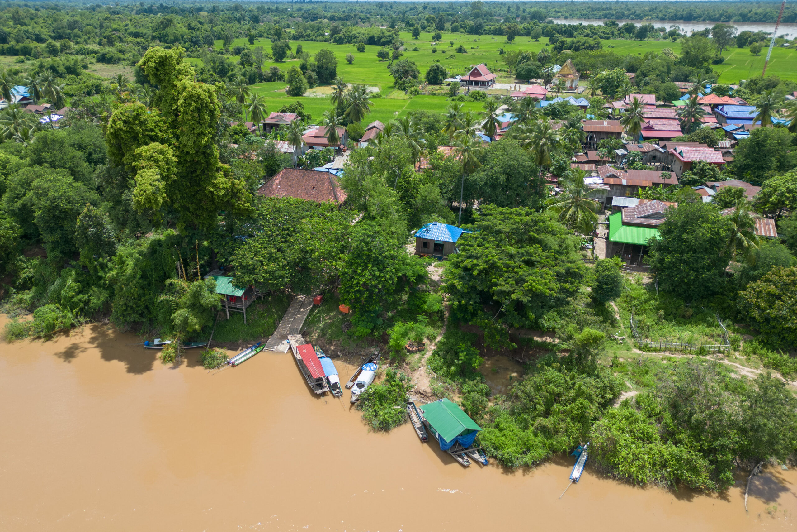
The fate of Koh Snaeng and the Stung Treng Ramsar site remains unclear. Image by Gerald Flynn/Mongabay.
‘Beginning of the end’
Ian Baird, a professor of geography at the University of Wisconsin who specializes in studying hydropower development across Cambodia, Laos and Thailand, says he’s heard rumors of the Stung Treng dam project being resurrected. While it remains unclear exactly what would be built or where and how, he says, the project is a significant threat to the Mekong region.
“The Ramsar Convention is quite weak as governments can really do as they please in Ramsar sites, but Cambodia has been more responsive to international conventions than its neighbors and historically more concerned than others about international criticism, compared with Laos or Vietnam,” Baird says, pointing to Cambodia’s 2020 moratorium on Mekong dam building — a move that other Mekong Basin countries have not followed.
“But this is one of the reasons why exposing the problems related to the Lower Sesan 2 is very critical, because it’s the same developers,” Baird says, adding he’d hoped the failings of Royal Group’s first hydropower project would ward the government off from approving another.
If the Stung Treng dam gets the go-ahead, Baird says it would be more damaging than the controversial Don Sahong dam and the Xayaburi dam — both on the mainstream of the Mekong in Laos — and more significant than the soon-to-be-completed Sekong A dam on the Laotian stretch of the Sekong River, a key tributary that flows from Vietnam, through Laos and into the Mekong River in Cambodia.
“There’s a lot of reason for concern here, if it goes ahead, well – it’s the beginning of the end,” Baird says. “The Mekong is dying a death by a thousand cuts, I’ve watched it for years, and honestly, it’s sad, but what can you do?”
Residents point to Royal Group’s history in Stung Treng province as a reason to be fearful, adding that a new, significantly larger hydropower project could have even wider-reaching impacts.
“I don’t know what I’ll do if they go ahead with it,” says Sai from Koh Snaeng.
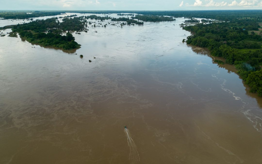
Featured image: A lone boat heads up the Mekong River through the Stung Treng Ramsar site. Image by Gerald Flynn/Mongabay.