U’wa struggle against tuberculosis, parasitic worms, climate change and the threats of violent paramilitary repression
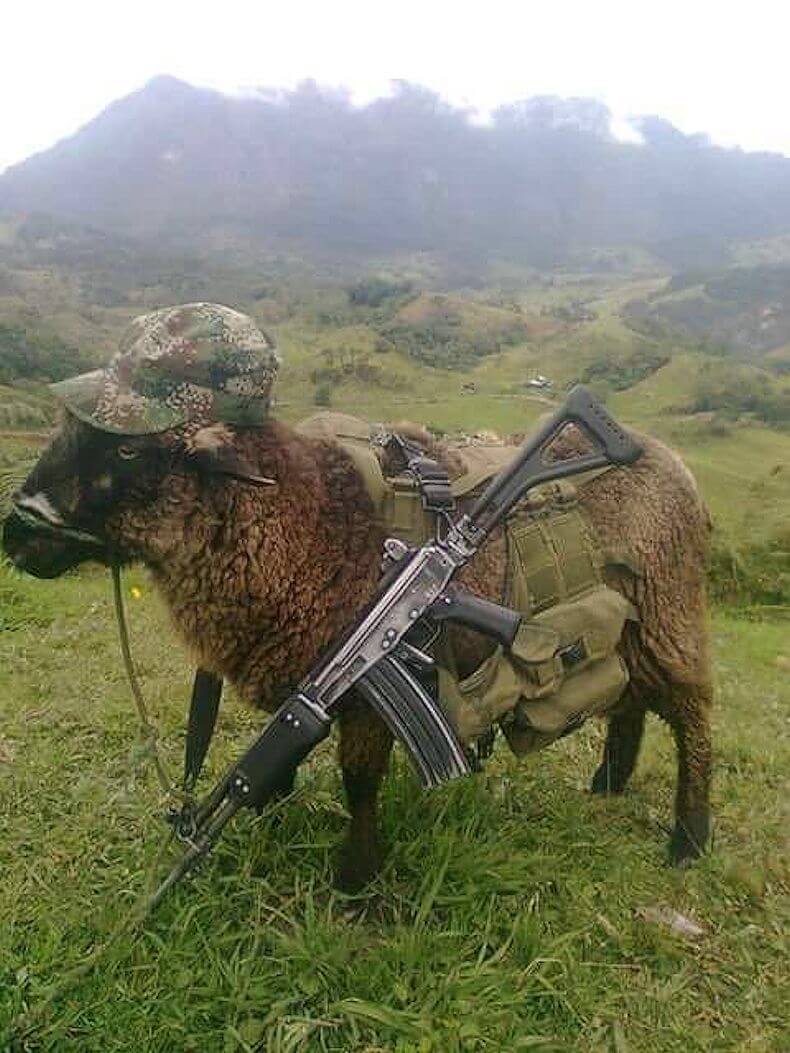
Featured image: “The U’wa were sent a photo of a sheep in military gear and carrying a rifle, implying that they are associated with the guerrillas. These are very serious accusations, providing a political rationale for violent paramilitary repression against the U’wa.”
—Andrew Miller, Director of Advocacy at Amazon Watch. Photo: unknown
This is the second installment of “The Guardians of Mother Earth,” an exclusive four-part series examining the Indigenous U’wa struggle for peace in Colombia.
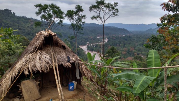
Nestled below the snow-capped mountains on the eastern cordillera of the Colombian Andes is the town of Güicán, known internationally to hikers as the gateway to Colombia’s magnificent Cocuy National Park. To the east of the mountain range the impenetrable tropical vegetation provides cover from air strikes for the guerrilla armies along the Venezuelan border. On the western border of U’wa territory the vegetation disappears with the altitude into a vast network of Andean peaks, valleys, and pristine wetland ecosystems called paramos.
It was here late last year during the October 25 municipal elections when the mountains surrounding Güicán became the scene of an ELN ambush resulting in the deaths of one policeman and 11 soldiers from Colombia’s High-Mountain Battalion. The battalion had left the U’wa resguardo at 3am and marched down a narrow mountain trail while carrying 130 votes cast by the remote indigenous communities of Bachira when they stopped to rest only to come under fire from rifles and guerilla rocket-launchers called “tatucos.” The sergeant leading the group communicated back to base that his security detail of 34 soldiers and two policemen charged with protecting delegates from the voting commission as well as an indigenous U’wa guide were under attack when radio contact was lost.
A coordinated air and ground assault was launched by the Colombian military to rescue the survivors and recover the bodies at an altitude of 9,842 ft where the tough mountain terrain makes helicopter access difficult. Two police were found wounded but alive while two soldiers as well as the U’wa guide and the civilians from the voting office remained unaccounted for as the ELN disappeared into the mountains. Vladimir Moreno, an indigenous U’wa leader, told El Tiempo there was no precedent for such violence in the region and that historically the guerillas had never interfered with the votes of local U’wa. “This is a peaceful community,” he said.
“We will request from national and international organizations to demand that the armed actors in the resguardo withdraw,” Moreno told Caracol Radio, “and we also demand from the Ministry of Defence that the Army clears out of the area within the resguardo because this has violated international humanitarian law.”
The incident, which was the most violent confrontation between the ELN and the state military since peace negotiations between the FARC and government started three years ago in Havana, resulted in the consequent militarization of U’wa and rural communities across the western border of the resguardo.
Now, six months later, Güicán is the epicenter for a non-violent U’wa mobilization: for the last few months the indigenous community has blocked the entrances of the Cocuy National Park. “The U’wa Nation is the Guardian of Mother Earth and from now into the future we will not permit tourism into the national park,” Yimy Aguablanca, an indigenous leader from Güicán, told IC on March 21, 2016. He added that tourism is affecting the water and the entire eco-system around the park and that non-indigenous rural people have joined the protest.
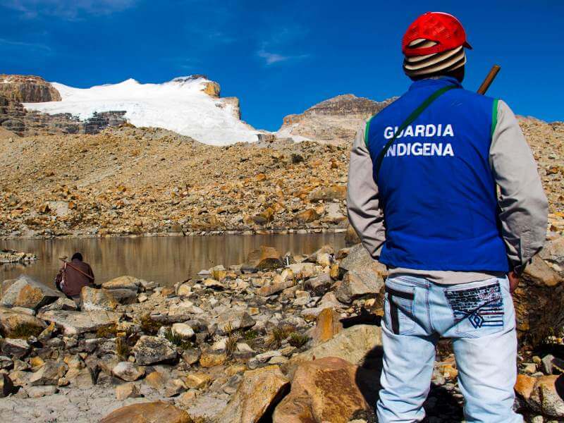
An U’wa Indigenous Guard. Photo: Tatiana Vila Torres / Kinorama Copyleft
The scarce facilities like rubbish bins and toilets in the state-run park mean some of the trails are littered with trash and visitors are forced to defecate beside the mountain streams that supply drinking water for surrounding communities. Outrage over the poor administration of the park was further inflamed in February when a charity match of high-altitude soccer was broadcast over YouTube. The match took place on the glacier of the U’wa’s sacred mountain Zizuma, the resting place of their divine beings. Known as Mount Cocuy in Spanish, an estimated 90 percent of Zizuma’s glaciers have disappeared in the last 150 years due to climate change. What little ice there is left is receding at a rate of 25 meters per year.
“Today we cry as our Zizuma is condemned to disappear,” went out the U’wa Communiqué that was broadcast through social media. Yimy Aguablanca said this latest mobilization of the U’wa will not stop until the state hands over administration of the park to the U’wa. So far, their calls for a direct dialog with the Minister of Environment have been ignored. The Constitution of 1999 allotted 220,275 hectares for the U’wa but this is a fraction of their ancestral lands, which once included the Cocuy National Park and areas rich with oil and gas reserves, which were conveniently left out of the agreement by the Colombian government.
In 2015, the U’wa High-Council made up of indigenous leaders from different communities across their territory, approved the creation of the Indigenous Guard. These guardians are responsible for territorial control and defense, and while unarmed, they have a mandate to ensure that no one enters the reserve without authorization, especially technical staff like geologists. The decision to form the Indigenous Guard came in response to an event in May 2014, when the U’wa detained functionaries from the company ENCOMINING who were in the Campo Hermoso region of their territory attempting to take coal samples. The importance of the current mobilization around the Cocuy National Park to not just the U’wa but also non-indigenous rural communities in the region is evident by the fact that rural farmers are now standing side by side with the Indigenous Guard to block all entrances to the park.
“Today when we look at our rights over our territory it is not the same as that of our ancestors,” Berito told IC. “It has been exploited, violated, distributed, but still even now we must always protect the water, the animals, and the forests.”
It was during ‘la Violencia’ — a dark period in Colombian history that began in 1948 — when the borders of the U’wa Nation’s territory were first reduced as thousands of refugees fleeing conflict from other parts of the country settled on the fertile banks of the Arauca. Instead of seeing enemies that needed to be vanquished, the U’wa saw victims worthy of compassion and retreated further into the mountains. Over the next 10 years, 200,000 people were killed as the civil war engulfed the country. La Violencia was eventually resolved by a power-sharing agreement in 1958 that turned Colombia into a dictatorship and consequently set the stage for a Marxist guerrilla insurgency against the central government.
Since 1964, another 260,000 people have been killed in the current incarnation of the Colombian armed conflict, and the war-torn provinces of Arauca, Casanare, Norte de Santander and Boyacá that overlap U’wa territory have become some of the most violent and militarized states in the country. In the north of U’wa territory in Norte de Santander, when word spreads of the Colombian army’s proximity, U’wa men race back from the fields to their families so the women are not alone in their homes.
To the south of the Cocuy National Park in Boyacá province, land that once belonged to the U’wa and is still considered sacred by their people has been violated by turning it into a permanent military base to defend nearby petroleum wells from five divisions of the FARC’s formidable Eastern Block and the heavy concentration of ELN fighters in Arauca and Casanare.
Although U’wa territory falling within the borders of the national park is protected from mining under the constitution, the proximity of these intense large-scale petroleum and gas exploitation projects has greatly affected the region’s fragile and delicately interconnected ecosystems. The Andean paramos that make up much of the terrain in the south and west of U’wa territory as well as the national park absorb water like giant sponges before releasing it into the rivers that nourish all life in the cloud forests on the eastern edge of the cordillera and the vast wetland Savana called Los Llanos that stretches thousands of miles into Venezuela.
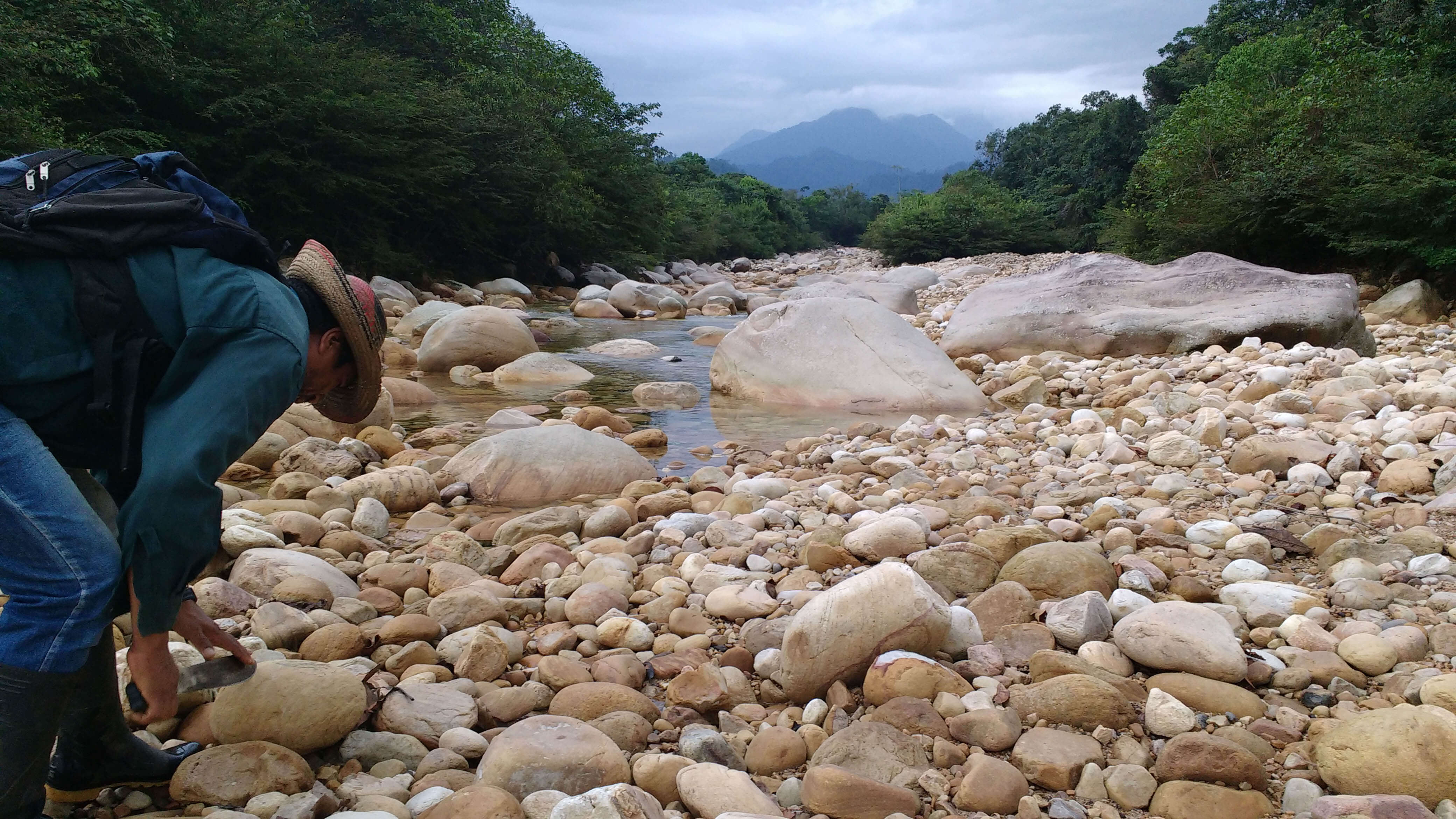
An U’wa bi-lingual teacher named Jose Cobaria sharpens his machete in the unusually dry Cobaria river. “The government invests all of its money in guns and war not education and health.” Photo: Jake Ling
These rivers are symbols of spiritual purity in U’wa cosmology, but a severe drought engulfing the region caused by overzealous mining in the Andean paramos, climate change and El Niño has turned these once mighty tributaries flowing through the U’wa ancestral lands into stony creek beds. To make matters worse, the once crystalline waters they carried from the snow-capped peaks and glaciers of the Sierra Cocuy and Güicán have been infected with a parasitic worm that stunts the indigenous children’s growth and swells their bellies, leaving them malnourished and lethargic while depleting their immune systems.
A dose of antibiotics from Cubará hospital can control the worm, but many indigenous families cannot afford the journey down the mountain to the town for a doctor’s prescription. Those that can make the trip to purge their children’s stomachs find out that after drinking one glass of water the worm is back. “We have to defend our health,” Berito told IC, “and this means examining the exploitation and contamination of the water which has cast a shadow over the rivers.”
“U’wa locals say the drinking water didn’t used to make them sick and that the parasitic worm which has recently contaminated the water supply severely affects indigenous children, swelling their stomachs and leaving them malnourished.”
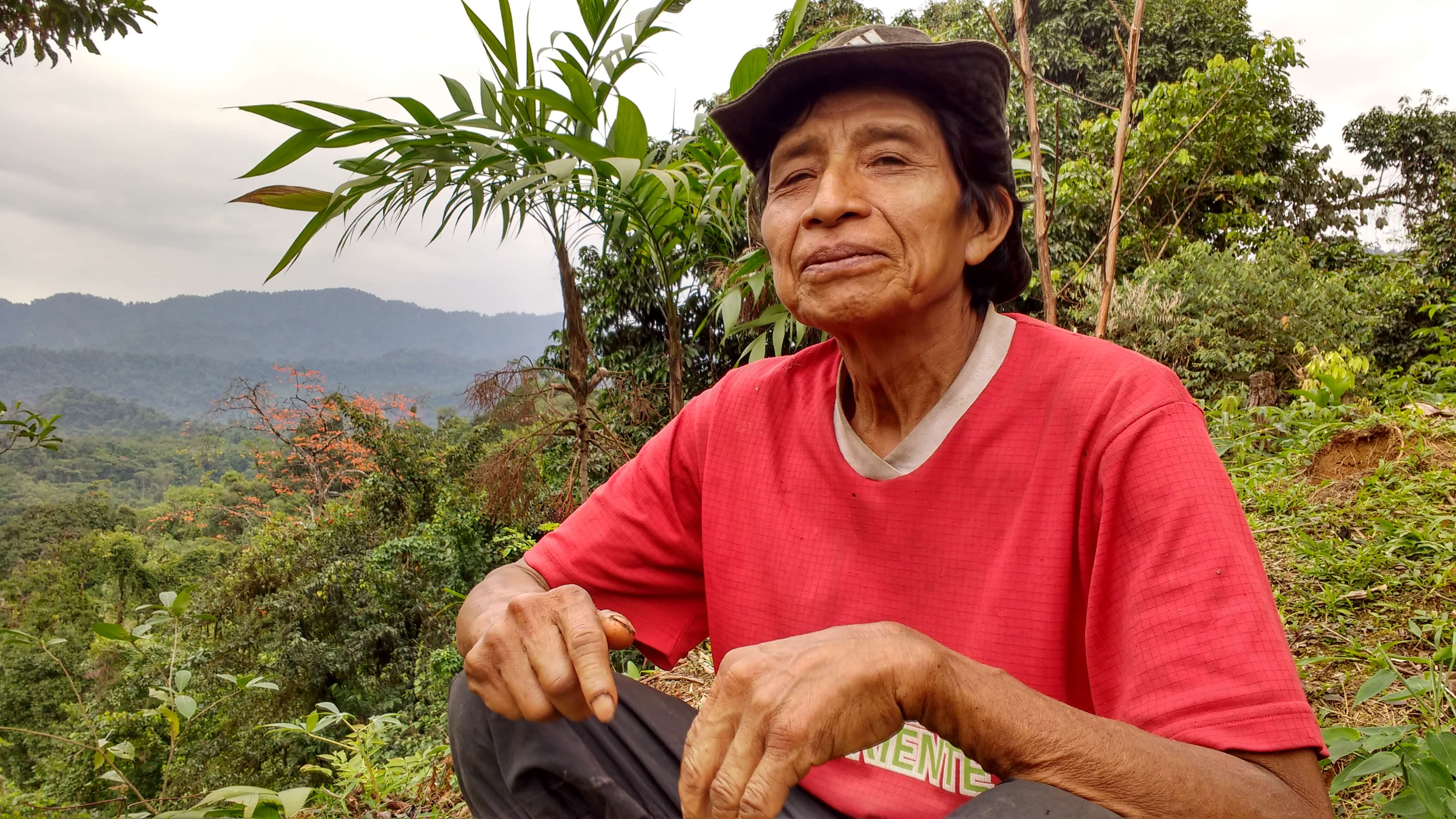
Further up the mountain, 50-year-old Kuiuru Kobeua has worked 8 hours a day for the last 14 days planting seeds on a small plot carved out of the forest to make sure his wife and three children do not go hungry come harvest. Two months ago, when his test for tuberculosis in Cubará hospital turned out negative, he was sent home with a packet of Ibuprofen. Two months later, he has trouble talking between violent coughs and the constant need to clear his phlegm-filled throat and lungs. He can barely afford another trip to Cubará and fears being turned back home again with nothing but another packet of painkillers. Meanwhile, the cough is not going away and he feels increasingly weak.
Until the Colombian government establishes a Tuberculosis Clinic in Cubará, the town’s under-resourced health clinic is unable to properly identify or treat the disease such as in the case of Kuiuru Kobeua, who was sent home from the hospital with nothing but painkillers. Photo: Jake Ling
“To prevent such cases of tuberculosis,” Yimy Aguablanca said, “we need to recognize and tell the world that the actual health policies of this government do not guarantee that our U’wa brothers are protected from the disease.”
On the other side of the U’wa’s ancestral territory the Earth First Journal reports that there are not enough seats for the patients in the tin-roofed off-the-grid medical clinic in Chuscal and that some of the sick are sprawled on the cracked floor tiles. Diseases such as tuberculosis, dysentery and leishmaniasis, a parasite spread by sandflies that attacks people’s internal organs, are rife. “We’re short of everything,” Eusebio Carceres, the head nurse at the isolated healthcare outpost, told Earth First. “Antibiotics, vaccines, lab equipment – we’re even short of clean drinking water because the oil spills have poisoned so many sources around here.”
Although the Colombian government routinely sends mining engineers into and around U’wa territory through state-run petroleum companies, the government’s failure to provide the region with uncontaminated drinking water or medical specialists to heal the community’s sick is striking.
The problems facing the U’wa are compounded by the limited arable land allotted to them in the constitution. It has forced them to change their agricultural practices. In decades past, the U’wa rotated crops to conserve soil quality and left areas to regenerate for up to 12 years before returning to ensure a bountiful harvest. Now the quality of soil is declining along with the quantity of their yields; sufficient food to feed the entire community is becoming increasingly scarce. Given the choice of clearing more of their sacred forests for agriculture or starving, however, the U’wa choose to fast. Amazon Watch neatly summed up the situation: although the U’was are pacifists who are unwilling to kill anyone for their beliefs, they are willing to die for them.
On the western paramos surrounding the sacred Zizuma, Yimy Aguablanca and a hundred other rural and U’wa protesters are standing firm despite the threats sent to the Indigenous Guard. On March 25, they received a cryptic photo of a sheep, grazing below the sacred mountain, dressed in guerilla military fatigues and carrying an assault rifle. The not-so-subtle threat means the U’wa have been categorized as an armed rebel group — and therefore a military target.
“When your protests disrupt an economic activity, you become a target of armed actors who operate on behalf of those interests,” said Andrew Miller, Director of Advocacy at Amazon Watch. He added that local politicians with ties to the tourism industry have been affected economically by the U’wa’s biocultural conservation efforts. Along with the threatening photo, Miller said that rumors are now circulating about the U’wa receiving bribes from the FARC to help them re-establish contraband shipment routes through the national park.
“These are very serious accusations providing a political rationale for a violent paramilitary repression against the U’wa,” Miller told IC. “The notion that the U’wa are associated with an armed group is absurd. They are actually radical pacifists by culture.”
The third installment in this series turns to recent history centered on Berito Cobaria, catholic missionaries and the international movement against Occidental Petroleum. It will be available soon on Intercontinental Cry.
This is the first installment of “The Guardians of Mother Earth,” a four-part series examining the Indigenous U’wa struggle for peace in Colombia.
On September 23, 2015, in the Palace of Conventions in Havana, Cuba, his excellency Juan Manuel Santos, the President of the Republic of Colombia, and Commander Timoleon Jimenez, Chief of General Staff of the Revolutionary Armed Forces of Colombia, signed an agreement on transitional justice and reparations to the victims of the country’s 51 year old civil war, resolving one of the final points in the country’s peace negotiations.
“We are adversaries, we come from different sides, but today we move in the same direction,” said President Santos, “this noble direction that all societies can have, is one of peace.”
In a show of unity, the warring parties all wore white-collared shirts without ties, as they sat on opposite sides of the brown mahogany tables encircling an artificially bright-green shrubbery arrangement. Around the room’s perimeter stood a throng of reporters, crowded together behind a red rope line, snapping photos of the historic handshake between the president and the leader of the country’s largest guerrilla army. A prolonged war that has killed more than 260,000 people and victimized and displaced seven million more seemed to be drawing to an end.
Among the victims of the conflict are the Indigenous Peoples of Colombia. Of the 102 tribal nations in existence today more than half are at risk of disappearing – forced displacement and mining on indigenous territory during the armed conflict have contributed heavily to the widespread demise.
A progressive genocide of negligence and privation is also taking place. The Indigenous Peoples of Colombia are routinely denied basic commodities such as antibiotics, vaccines and clean drinking water that residents of big cities take for granted, not because the country’s indigenous have been targeted for extermination, but because they have become politically insignificant.
During the Havana peace accord, the indigenous nations who trace their Colombian heritage back thousands of years, from before the time of the Spanish conquest, were not mentioned once.
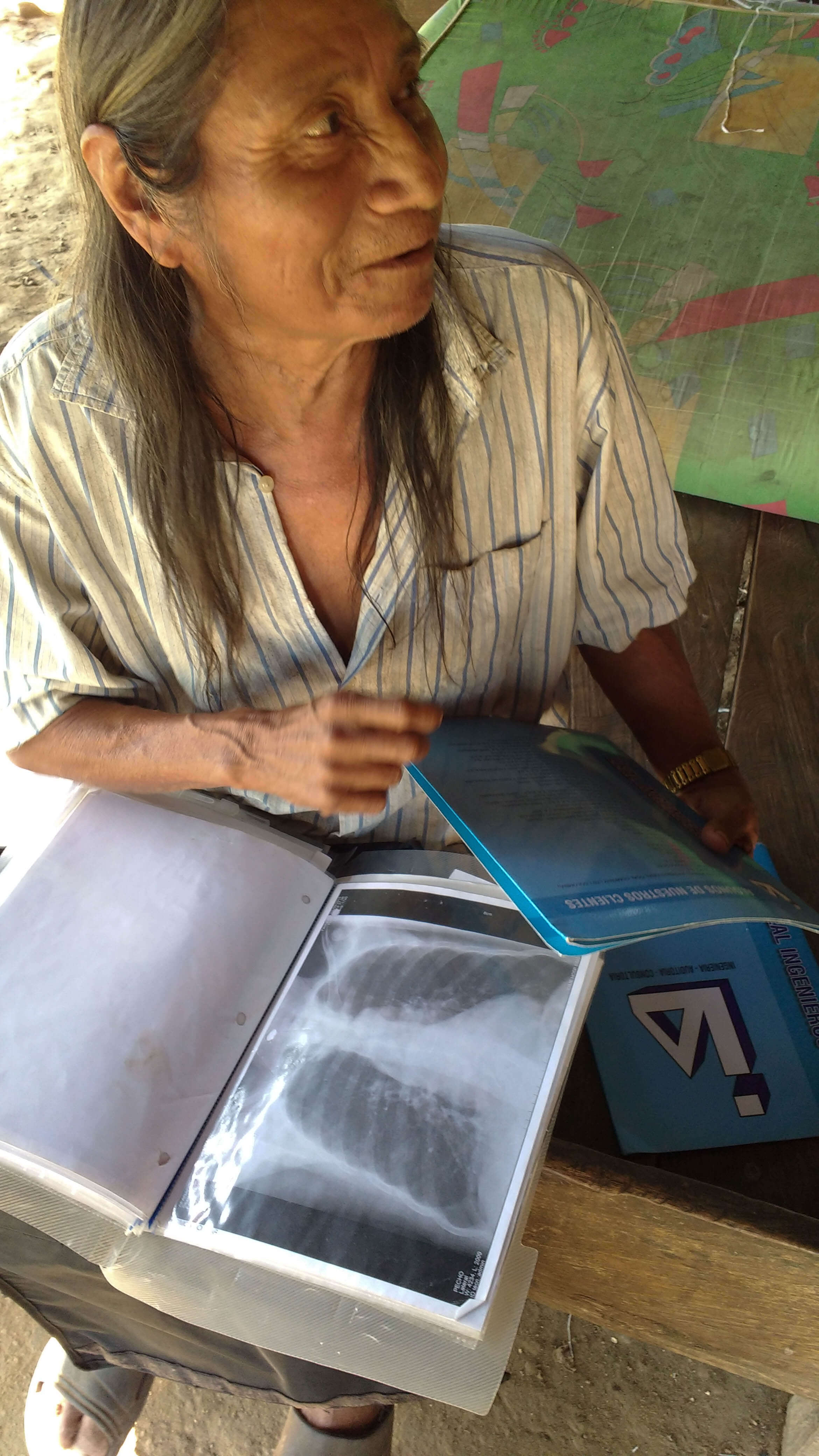
Inside a wooden shack in the isolated cloud forests of eastern Colombia, three kilometers west of the Arauca river on the Venezuelan border, Berito Cobaria, the internationally recognized leader and spiritual guide of the indigenous U’wa, points out the shades on the x-ray scan of his chest. It shows the same strain of tuberculosis that is ravaging his people.
Berito X-ray. Photo: Jake Ling
The single-story hospital in Cubará, the nearest town on the river, is poorly equipped and understaffed. Visits from medical specialists are rare because the hospital is located in the “Red Zone” – conflict areas the Colombian government has declared dangerous due to the heavy concentration of guerrilla forces.
“The government needs to establish a tuberculosis clinic in Cubará,” Berito told IC. He confirmed he is slowly overcoming the deadly disease but despairs for his people as the tuberculosis outbreak rapidly spreads throughout the U’wa Nation’s ancestral lands. The U’wa believe there needs to be harmony in the world for there to be harmony in the cosmos, but the balance of nature has been disturbed and a sickness has fallen upon Berito’s people. Infectious western diseases such as influenza, dysentery, tuberculosis, and the common cold continue to wreak havoc on the unaccustomed immune systems of the U’wa, who up until the late 1940’s lived an isolated existence on the forested cliffs and the remote Andean wetlands and cloud forests of eastern Colombia.
Beginning on February 13th, 2016, Colombia’s second largest guerrilla army, the ELN (Army of National Liberation) imposed a 72-hour armed strike inside Red Zones like Cubará and other towns that border U’wa territory. Under the threat of violence, all stores and businesses in Cubará were closed, the roads were empty and lucky members of the Colombian military got three days’ rest in fortified outposts while their colleagues searched for explosives laid along Highway 66. Despite their dominance in the frontier towns along the Venezuelan border, even the ELN needs to gain permission from indigenous authorities like Berito to enter the ancestral lands of the U’wa. Known as the United U’wa Resguardo, the territory is restricted to all outsiders.
A day after the ELN’s armed strike was lifted, U’wa families on their way to Cubará to stock up on supplies of bread, sugar, eggs and tobacco were traveling barefoot or on the backs of pickup trucks past Berito’s home, which stands sentinel on the eastern border of the resguardo. Ten minutes away at the border town, Colombian soldiers had returned from their outposts to patrol the streets. Stores were serving clients, and locals walked openly with white plastic shopping bags, acts that had been banned and punishable by death during the armed strike. The only trace of the armed strike was the ubiquitous graffiti scrawled on buildings around town: “ELN – 51 YEARS OF RESISTANCE”.
Historically, U’wa territory has been of strategic importance to the Marxist guerrillas because it connects the contraband routes from Venezuela over the Arauca river to the central Andes of Boyacá province, a short drive from the capital Bogotá. Unarmed outside of the agricultural tools they use to cultivate staple crops of yucca, plantains and potatoes, the U’wa authorities will reluctantly grant permission to the ELN to pass through the resguardo on the strict condition they do not set up camp inside their territory. In return the ELN respect U’wa sovereignty, will not enter without permission and will not stop until they have traversed the steep and extremely difficult climb out of the cloud forests and cross the western border of the resguardo, below the snow-capped mountains of the Sierra Cocuy and Güicán.
This region, which is rich in lucrative oil and gas reserves, is also of great strategic importance to the United States’ and Colombian governments, multinationals like Houston-based Occidental Petroleum and Spanish oil giant RepSol, as well as the right-wing paramilitary death squads, which have been historically allied with the central government and big business. For the U’wa Peoples, however, oil is the sacred blood of their Mother Earth, and without its blood their mother will die. For more than two decades U’wa have mobilized aggressive non-violent campaigns to assert more control over their ancestral territory in the midst of one of the most troubled regions of the Colombian Civil War, but it was their struggle against Occidental Petroleum (called Oxy for short) that gained international attention in 1997, when Berito declared that his people “would rather die, protecting everything that we hold sacred, than lose everything that makes us U’wa.”
Oil blocks on U’wa territory. Map by Fidel Mingorance / HREV 2014
As Oxy pushed into the U’wa’s ancestral lands, the indigenous nation collectively threatened to commit mass suicide by leaping off a 15,000-foot cliff if drilling on their territory went ahead. This was not a publicity stunt. U’wa tribal lore tells of their people walking off the “Cliffs of Glory” en masse centuries ago rather than submit to the brutal Spanish conquistadors. The U’wa set up a makeshift village beside Occidental Petroleum’s Gibraltar 1 drilling site, and were clubbed, tear-gassed, threatened with rape, evicted, arrested, and harassed by state security forces on behalf of Oxy. A year later in 1998, Berito was given the prestigious Goldman Environmental Prize for leading the non-violent campaign against Occidental Petroleum – the same year the US multinational was complicit in the cluster-bombing of a countryside agricultural community, killing 18 civilians including 9 children, near the resguardo’s south-eastern border, in order to protect the Caño-Limon-Covenas oil pipeline.
The pipeline, jointly run by state-owned Ecopetrol and US-based Occidental Petroleum, pumps up to 220,000 barrels of crude daily from the war-torn Arauca province through U’wa territory on its way to the Caribbean coast. It was also the beneficiary of $100 million US military aid that was granted to the Colombian army in 2003, after Occidental Petroleum spent $4 million lobbying the US government to protect it. The ELN, and their ideological ally, the FARC, have bombed the pipeline more than a thousand times. The consecutive attacks over decades have spilt millions of barrels of cancerous unprocessed crude into the rivers and forests of the region, exponentially more than that of the Exxon Valdez environmental disaster.
In a separate bombing incident in March 2014, the U’wa refused to permit repairs to the pipeline until the government began dismantling the Magallanes drilling site on the northern border of the U’wa resguardo, which Ecopetrol had set up in secret months earlier. The Wall Street Journalreported the Colombian government lost $130 million during the 40-day U’wa protest, which was resolved by dismantling the new drilling rig. Ecopetrol has not cancelled the mining license, however, and the threat of exploitation remains. The most recent attack on the pipeline was a twin bomb attack by the ELN on March 15th, 2016, a week before the deadline to finalize the preliminary peace agreement that President Santos and Commander Timoleon Jimenez had agreed to six months earlier in Havana.
As the March 23rd deadline came and went without even a symbolic gesture of unity, both the FARC and government blamed each other for stalling. A week later the government saved face by announcing to the press it had entered formal peace talks with the ELN, but the country’s second-largest guerrilla army watered down public optimism by stating negotiations would not stop them from attacking critical government infrastructure, which include mining assets in the region and oil concessions surrounding U’wa territory such as Oil Block Cor 19 and Cor 45 which extend across the west and north-west of the resguardo; the Arauca oil block; and RepSol and Integra Oil drilling rigs on the resguardo’s eastern border. There is also Ecopetrol’s Siriri Oil Block, which along with Caño-Limon-Covenas is located in the north of U’wa territory.
A small fraction of a percent of the money rolling in from this multi-billion dollar mining bonanza would be more than enough to fund schools, provide fully-stocked healthcare facilities and install piping to provide clean drinking water for every indigenous and rural community in the region. In one isolated U’wa school inside the resguardo, four computers generously donated by the Colombian government gather dust because there is no electricity; here many of U’wa children are malnourished with swollen bellies because a non-native parasitic worm has contaminated the water supply. In a tin-roofed shack that serves as a hospital in Chuscal on the other side of the resguardo, the head nurse complains of the difficulty of caring for patients suffering from tuberculosis and dysentery because of a lack of vaccines, antibiotics and even clean drinking water after an oil spill contaminated the river.
Now while the international community is openly discussing buzzwords like “Peace Colombia” and “post-conflict” in anticipation of a historic peace agreement between the FARC and government, the U’wa people are demanding high-level talks with the government to address their various grievances. The government response has thus far been to ignore the U’wa, or to invite an indigenous delegation to Bogotá where low-level bureaucrats with no authority merely shuffle papers and nod their heads. Meanwhile, the tuberculosis outbreak continues to spread across U’wa territory.
The U’wa, who call themselves the people who know how to think and speak, consider themselves the Guardians of Mother Nature, and large tracts of land inside their territory have become biological reserves for jaguars, spectacled bears, as well as a kaleidoscopic array of endemic plant and bird life that do not appear anywhere else on the planet. As an ambassador for his tribe, Berito has traveled the world recruiting the support of activists of all stripes, from the late Terry Freitas, native American activists Ingrid Washinawatok and Lahe’enda’e Gay, to the founder of Amazon Watch Atossa Soltani, and Hollywood celebrities like Avatar director James Cameron.
The indigenous leader knows that the ability of his pacifist tribe of 7,000 people to defend themselves against these extremely powerful economic and political forces is limited. This is especially true while numerous multinationals and armed groups battle for control around and sometimes inside his people’s land hidden from the eyes of the international community beneath the forest canopies. Non-violence, however, needs an audience and once again the U’wa leader is calling upon the world to watch over his people.
“History is its own kind of law,” Berito said. “They say the land is dead, but it lives yet. It is only wounded by the taking of oil. The dignity of native peoples comes from the land – and like the land it can be saved.”
The second installment in this series examines the U’wa struggles against tuberculosis, parasitic worms, climate change and threats of violent paramilitary repression. You can read it here: They say the land is dead, but it lives yet
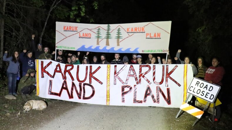
In the early morning hours before daybreak on May 2 in the fire-impacted conifer forest near Seiad Valley in the Klamath River watershed, 27 people including Tribal youth, river advocates and forest activists blocked the road leading to the Klamath National Forest’s Westside salvage logging project.
Demonstrators held banners that read ‘Karuk Land: Karuk Plan,’ recited call and response chants, and testified to the timber sales’ impact on ailing salmon populations. Work was delayed for approximately four hours, according to a news release from the river advocates.
The protesters said the Westside Salvage Logging Project would clear cut more than 5,700 acres on steep slopes above Klamath River tributaries and along 320 miles of roads within Klamath National Forest. Post-fire logging and hauling began in late April, before legal claims brought forth by a lawsuit led by the Karuk Tribe could be considered in court.
“The Forest Service should follow the Karuk Plan on Karuk Land. Traditional knowledge of fire helps everything stay in balance because it’s all intertwined,” said Dania Rose Colegrove of the Klamath Justice Coalition. “When you destroy the forests, you destroy the rivers.”
The protesters said the Westside plan, unlike the Karuk Alternative, calls for clear cut logging on steep slopes right above several of the Klamath River’s most important salmon-bearing streams, at a time when returning salmon numbers are reaching record lows.
Members of local Tribal youth councils who participated in the protest see Westside salvage logging as a threat to their future.
“Today I showed up and stood up for what is right for future generations,” said Lacey Jackson, a 16-year old Hoopa Tribal Youth Council member. “My cultural and traditional livelihood is being threatened, and the way they are going about this logging is a big part of that. I will continue to stand up for me, my people and future generations.”
River advocates say the Forest Service plan to clear-cut thousands of acres above the Klamath River disregards the reasonable Karuk Alternative and hurts at-risk salmon and river communities. They believe a healthy Klamath River requires sensible forest restoration that addresses the needs of both fish and people, like that laid out in the Karuk plan.
Federal and state fisheries agency scientists estimate that there are only approximately 142,200 Klamath River fall-run Chinook salmon in the ocean this year, based on the returns of two-year-old salmon, called “jacks” and “jills.” The salmon from the Klamath and Sacramento River make up the majority of salmon taken in California’s ocean and inland fisheries.
The low numbers of Klamath and Trinity River fish expected to return to the river and tributaries this year will result in more restricted seasons for both the recreational and commercial fisheries on the ocean and recreational and Tribal fisheries on the rivers this season.
During a meeting on Klamath dam removal in Sacramento in March, Thomas Wilson, a member of the Yurok Tribal Council and owner of Spey-Gee Point Guide Service, described the dire situation that the salmon fishery is in this year.
“This season will be devastating for fishermen and people on the river. Usually we get around 12,000 fish for subsistence on the river and what’s left goes to the commercial fishery. This year our entire Tribal quota is only about 5,900 fish,” he explained.
“The people are praying that the science predicting the low numbers is wrong. If we don’t protect the fish now, it will hurt us down the road. As Yuroks and natives, we are conservationists. We want make sure enough to keep seed for the all of the resources for future generations,” Wilson said.
The last thing that the watershed needs, at a time when the fishery is in crisis, is a Forest Service-approved clear cutting plan that further threatens salmon and steelhead habitat.
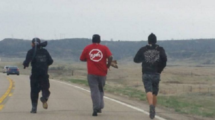
Omaha, NE – In solidarity with the ongoing fight against the Dakota Access pipeline, a group of Native and Non-native youth have organized a 500-mile spiritual relay run from Cannonball, ND to the district office of the United States Army Corps of Engineers (USACE) in Omaha, NE. The run is titled “Run For Your Life: No DAPL.” It departed the Cannonball community on April 24th, 2016 and plans to arrive in Omaha on May 3rd, 2016. The intention of the run is to deliver an unified statement to the USACE in resistance to the oil pipeline that proposed to cross beneath sacred water needed for life. The runners will will also turn over a petition calling for a full Environmental Impact Statement (EIS) to be conducted on the Bakken pipeline.
The running group is currently in Lake Andes, SD and plans for one day of rest, departing for Santee, NE on Thursday, April 28th.The participating runners are comprised of concerned citizens from across North Dakota, South Dakota, Nebraska and Iowa.
For the past several months, Native and non-Native peoples in the Midwest have been battling the construction of the Dakota Access/Bakken pipeline, a project that will go from North Dakota into South Dakota, Iowa and southern Illinois. If constructed, this large-scale pipeline will cross the 12,000 year-old Missouri River, one of the largest water resources in the United States that supports millions of people with drinking and irrigation water. The U.S. Army Corps of Engineers has stated that they will make the final decision on Dakota Access, LLC’s final permit needed to construct the Dakota Access/Bakken Pipeline no later than May 6th, 2016 .
Dakota Access Pipeline (DAPL), owned by Energy Transfer Partners, L.P., is proposed to transport 450,000 barrels per day of Bakken crude oil from the lands of North Dakota to Patoka, Illinois. Dakota Access Pipeline is proposed to cross under the Missouri River twice, and poses as a threat to the sacred waters that the entire breadbasket of America depends on. The construction of Dakota Access will threaten everything from farming and drinking water to entire ecosystems, wildlife and food sources surrounding the Missouri.
The group asks that “Everyone stand with us against this threat to our health, our culture, and our sovereignty. We ask that everyone who lives on or near the Missouri River and its tributaries, everyone who farms or ranches in the local area, and everyone who cares about clean air and clean drinking water stand with us against the Dakota Access Pipeline!”
Dallas Goldtooth, Organizer with Indigenous Environmental Network, said: “We can not accept the risks an oil spill will cause upon the heartland of America. We cannot accept the trespassing across Oceti Sakowin lands by Big Oil. We cannot accept locking ourselves into more fossil fuels when Mother Earth demands us to leave fossil fuels in the ground. This Dakota Access pipeline is all risk, no reward. Simple as that.”
In a landmark victory for indigenous land rights in Brazil, the National Foundation for the Indian (FUNAI) has decided to proceed with the official demarcation and protection of the Munduruku Peoples 700-square-mile ancestral territory on the Tapajós River, in the Brazilian Amazon.
The land demarcation is a major political win for the Munduruku Peoples. Under existing Brazil legislation the construction of hydroelectric plants that flood demarcated Indigenous lands is expressly prohibited. This means the Munduruku’s historical territory must now be spared from the same dam-driven destruction witnessed in the Xingú region since construction work began on the controversial Belo Monte dam project. The recent move by FUNAI also sets a new legal milestone for Indigenous Peoples demanding land demarcation as a way to protect their territories.
THE DEMARCATION OF MUNDURUKU LANDS
FUNAI, the Brazilian acronym for Fundação Nacional do Índio, announced the decision to demarcate the Munduruku’s territory on the Day of Indigenous Peoples, April 19, 2016.
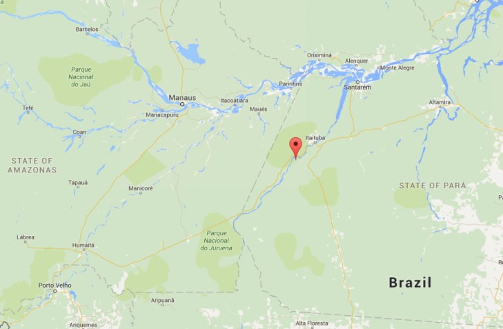
Acting in its official capacity as the government body responsible for establishing and carrying out policies relating to Indigenous Peoples, the institution published documents identifying and recognizing the Munduruku’s ancestral rights to Sawré Maybu, a territory of 178 thousand hectares located between Itaituba and Trairão, in the state of Pará.
Approximate location of Sawré Muybu demarcation area. Map by Google Maps
FUNAI’s decision to demarcate ends a long-standing and heated political battle between Brazil’s energy sector and Indigenous Peoples in the Tapajós. For at least the last five years, the energy sector has insisted that no Indigenous Peoples have ancestral ties to the region. FUNAI’s announcement brings an end to that argument, confirming that the Munduruku have historical ties to the dam-threatened area.
The final demarcation still depends on a presidential decree that cannot be published for 90 days – a normative timeframe to allow questions and debate to take place – nevertheless, the Munduruku territory is now all but secured from the consequences of the São Luiz do Tapajós dam.
Munduruku cacique (leader) Jairo Saw considers FUNAI’s decision to be an historical victory that indicates the articulation of Indigenous struggles in the Tapajós region.
FUNAI’s President João Pedro Gonçalves da Costa, complimented the cacique’s sentiment, stating that the recognition is unavoidable. “It is impossible and unacceptable to deny the tradition and historical presence of (Munduruku) peoples in the Tapajós,” he said.
THE HYDRO-PROJECT SÃO LUIZ DO TAPAJÓS
The São Luiz do Tapajós dam carried an estimated cost of BRL$32.52 billion (USD$9.12 billion) and would have generated on average 4.012 megawatts per year, about the same as the Belo Monte Dam, also in the state of Pará. On its own, the São Luiz do Tapajós dam would provide almost half the energy of all other hydroelectric plants planned in Brazil for the next ten years, supporting over 20 million homes.
Yet its environmental and human cost was brutal. The São Luiz do Tapajós dam would not only take the Munduruku’s ancestral lands. The total flood area would encompass 729 square kilometers of pristine Amazon rainforest. To put things in perspective, the Belo Monte Dam flood is set to flood 503 square kilometers.
Like the Belo Monte dam, the São Luiz do Tapajós dam has been constantly entangled in judicial irregularities and corruption scandals. In 2014, Brazil’s government announced the dam without an environmental license, a fatal move that forced the government to cancel planning a couple days later. When a judge ordered FUNAI to expedite land demarcation in the affected area, the Federal Government in Brasilia overturned the ruling claiming there was no need for demarcation.
The government stakes were high, placing considerable pressure on then-director of FUNAI Maria Augusta Assirati to uphold the process of land demarcation. She admitted in a meeting with Munduruku authorities that she was expected to secure the hydro dam’s interests.
Just days after that meeting she resigned from her post.
FUNAI held back the land demarcation for years. Jairo Saw, cacique of Sawré Maybu, said that when they realized that they could not count on FUNAI the community decided to start the process of demarcation on its own, autonomous from the government.
In 2016, the dam project was placed on the market once again; the government repeating its past failure to carry out a free, prior and informed consultation process with the Munduruku as required by the Convention 169 of the International Labor Organization (ILO 169).
THE SUPPORT OF BROAD COALITIONS
The absence of land demarcation resulted in various forms of abuse and the mobilization of the UN Special Rapporteur on Indigenous Issues to the region. In March 2016, Victoria Tauli-Corpuz visited Altamira to hear complaints and testimonies about the planning of the hydro-plant. She met with 13 representatives from various communities from the Tapajós river valley: munduruku, arara vermelha, apiaká, arapiun, borari, jaraqui, kumaruara, kayabi, tapajós, tapuia, tupaiú, maytapu, cara preta e tupinambá.
Indigenous Peoples denounced the disrespect of the patrimony through the state of Pará. In addition to hydro dams, they explained at the time they were also victim to the invasion of loggers, mining, agri-business, and even carbon credit projects. The violence on their lands was tacitly permitted by the silence of judicial institutions in Brasilia.
During her visit, Tauli-Corpuz foresaw that it was possible to paralyze the dam construction. She encouraged the Munduruku to continue their resistance. She also talked about her own experience resisting the construction of a dam in the 1970s-1980s in the Philippines. Their unity gave them strength, she later claimed, in a struggle that is not only for the Mundurku but for all Brazilians, for generations to come.
Solidarity ultimately led the way to success. Strong collaborations among communities from the Xingú and Tapajós regions played a crucial role in achieving the land demarcation.
Community leaders from the two regions recently met to celebrate a commitment of cooperation and mutual support. At their gathering, they sealed an agreement to gather all their force to prevent the consequences of the Belo Monte from being repeated in the Tapajós river basin.
In the recent past, the Munduruku also issued the Munduruku Consultation Protocol demanding their right to prior consultation in accordance with international law and Brazil’s constitution.
With the Munduruku and their allies standing at the ready, they now await the President’s decision to uphold the letter and the spirit of Brazilian law.