Standing in a pinyon-juniper forest on a high slope above Cave Valley not far from Ely, Nevada, I am lost in an ancient vision. It is a vision born under sublime skies stretching above wide, flat valleys bounded by the dramatic mountains of the Great Basin. The vision grows with the rising flames of morning in the east. The night was cold, but clear, and the sun brings a welcome warmth. When the sun crests the mountains, red and orange clouds stream across the sky while shadows pull back from the valley floor to reveal pronghorn antelope dancing through the sage brush. A few ridge lines away, the clatter of talus accompanies the movement of bighorn sheep. The slap and crack of bighorn rams clashing their heads together echoes through the valley.
As the morning passes, the sun shines through pine needles and juniper branches to dapple the forest floor in silvers and golds. The trees offer shade where patches of snow glimmer and whisper with the smallest sounds of melting. Pinyon pine cones are scattered across the ground. As they open, their seeds – delicious, nourishing pine nuts – become visible. Beautiful, blue-feathered pinyon jays gather the nuts in their beak before flying off to cache them for the deepening winter.
Humans have long participated in this vision though the vision is far older than them. From a place deeper than my mind’s memory, in the memories of the borrowed materials forming my body, I feel a kinship to this land’s original peoples. For thousands of years, in this part of the Great Basin, Shoshones and Goshutes have stood looking out at valleys like this one as they gathered the pine nuts that provided the most important winter food source making it possible for humans to live in the Great Basin’s harsh climate.
As I let my memory flow into the past, I see hundreds of generations of Shoshones and Goshutes living well off the gifts the land freely gives. Living in this way, I know their relationship with the land could have lasted forever. Pinyon pines could have gone on offering their pine nuts to jays, rats, and humans. Junipers could have gone on twisting in wooden gymnastics and growing their bundles of blue berries.
A herd of cattle catches my attention and I remember that this is just a vision, after all. The presence of cattle, here, forces me to confront the reality of the Great Basin’s ongoing destruction. An anxiety accompanies the cattle. It is the anxiety that flows from the knowledge of ecological collapse. I envy the hundreds of generations of Shoshones and Goshutes who had no reason to question the eternity of their culture.
Following the slow steps of brown and black cows, I see a metallic glint on the valley floor where streamers are tied onto fences built by ranchers so that sage grouse will not fly into the fences and kill themselves. I have seen the bundles of feathers and blood mangled and stuck in the wire fences. The cattle march to a shallow pond. A thin, but growing ring of algae floats on the pond’s surface while piles of cow shit litter sandy soil stripped of any vegetation. From the pond comes a strangled, gurgling sound. Despite the drought, water is being pumped from already strained wells to support the cattle.
The valley floor is striped in green and yellow patches. The green patches represent healthy, native sage brush and the yellow patches represent invasive crested wheat grass. I have learned how in the 1950s and 60s, the Bureau of Land Management (BLM) initiated a series of projects designed to strip away sage brush to replace it with imported Asian crested wheat grass. Not long after white settlement cattle herds wiped out most of the native grasses in the Great Basin, so now the land must be forced to support them. Destroying the sage brush has had disastrous consequences including contributing to the collapse of sage grouse populations who, as their name suggests, require healthy sage brush for habitat.
Above the valley floors, where the pinyon-juniper forests drape across the mountains’ shoulders, are brown swaths cut into the land where the forests have fallen victim to the BLM’s so-called “vegetation treatment projects.” These vegetation treatment projects are really just clear-cuts justified by the BLM as “providing woodland products to the public,” “maintaining sage brush habitat,” and “protection of property and infrastructure.”
As my experience of this ancient vision disintegrates with the reminders of the processes threatening life in the Great Basin, I remember why I came here. I came, specifically, because I had heard of the BLM’s practice of clear-cutting pinyon-juniper forests. Friends of mine asked me to write about threats to pinyon-juniper forests. I had never seen a clear-cut pinyon-juniper forest before, I knew very little about the Great Basin at all, and I’ve always thought the best way to write about the land is to seek a true relationship with it.
So, my friend, the great activist, writer, and photographer Max Wilbert flew to Salt Lake from Eugene, Oregon and we made plans to drive from my home in Park City, Utah to Nevada to see both living pinyon-juniper forests and clear-cuts. We met up with Katie Fite, a biologist and the Board Secretary for the environmental protection group, WildLands Defense. Katie brings over 30 years of on-the-ground experience to environmental advocacy possessing expertise in the Great Basin’s ecology.
***
I walk through the shades and shadows of a healthy pinyon-juniper forest. Songbirds create their music celebrating the beauty of their home. Social ravens gossip back and forth diving down to ask who I am. From time to time, I catch a grey glimpse of a rabbit bounding out of my path. The gentle hooting of an owl falls from the treetops. Though I am several hundred yards from any of my companions separated by ridge lines and hundreds of trees, I do not feel alone. A sense of deep familiarity, the feeling shared when friends gather, settles over me.
It is the 19th of November. The full cycle of seasons in the Great Basin carries the range of temperature extremes. The summers are dry and hot and the winters are frigid with plenty of snow. Even a single day in the Great Basin reflects these extremes. Last night dropped below freezing and I woke with a crisp layer of frost on my sleeping bag at dawn.
In the cold times like these, the slopes of the mountains are the warmest places to be because as the sun comes up and heats the air on the valley floor, the warm air rises. The slopes of the mountains are also where the pinyon-juniper forests are. By mid-morning, the sun is strong and hot. Even though the temperatures fell into the teens Fahrenheit last night, the temperature gains the 60s by noon. The forests, then, are the most comfortable places to be in both the cold night and the hot day. The forests are warmer at night and in the morning than the valley floors, and when the sun beats down during the day the trees offer soothing shade.
It feels, to me, that these ancient pinyon-juniper forests enjoy caring for humans.
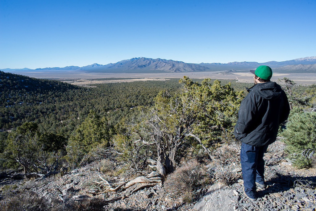
I feel I could walk through the forest like this for miles. Then, the trees abruptly stop. The shade ceases and the sun strikes my eyes with a physical force. A cold wind, driven wild over unbroken space, slaps my face. The sudden openness is a shock. I almost trip. Behind me is a living forest, before me is a void.
I have stepped into a clear-cut.
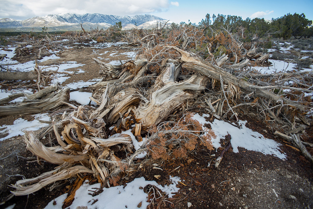
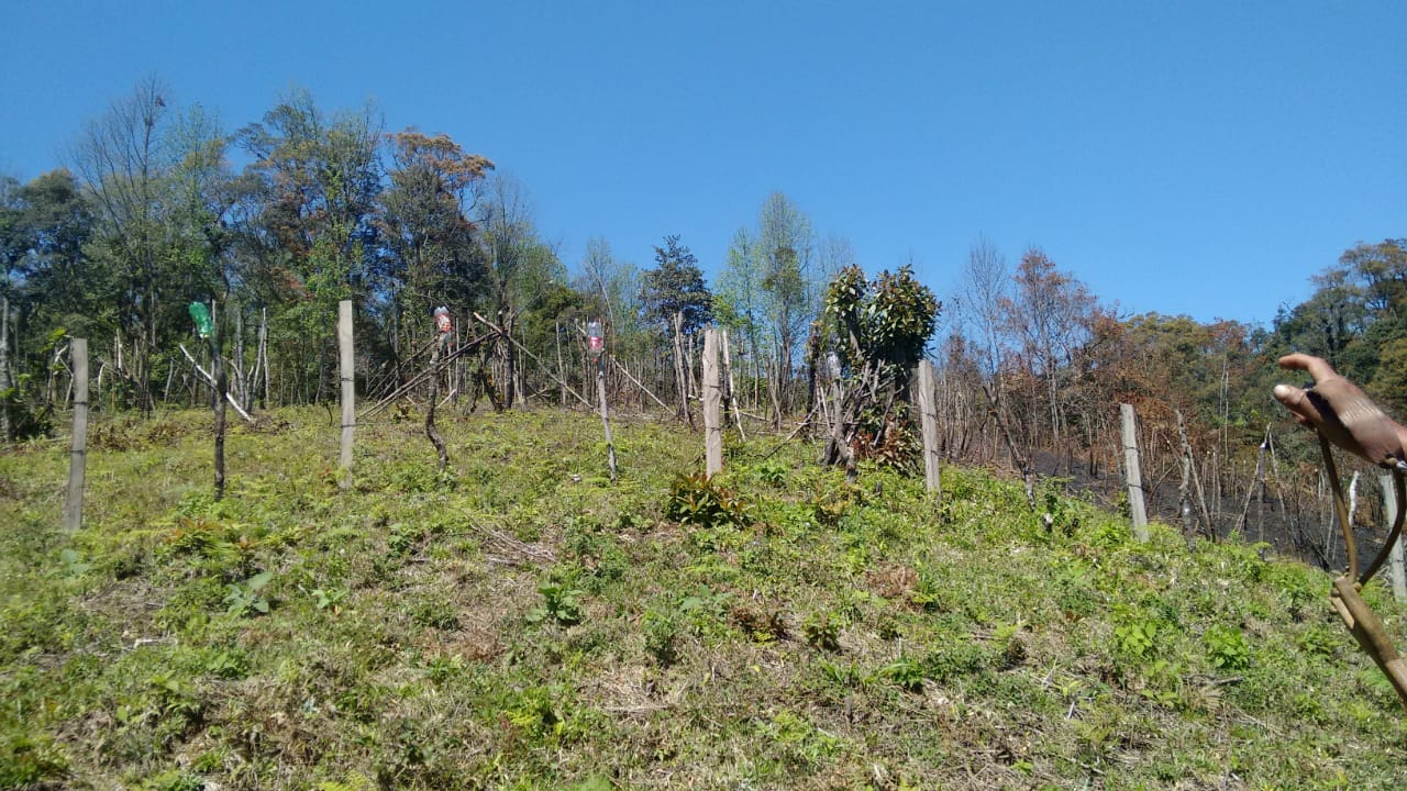
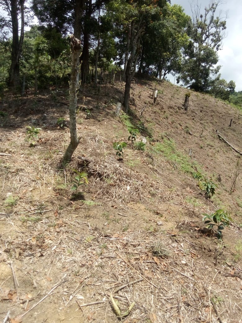
To my left for a mile, to my right for a mile, and a quarter mile across, the land is brown. The long limbs of pinyon pines slump across the gnarled trunks of junipers. I have only seen pictures of human massacre sites. Bodies, frozen and stiff, heaped in piles. And these clear-cuts are truly tree massacre sites.
I can tell this particular clear-cut was “chained.” Chaining is a practice employed by the BLM and is done by stretching a U.S. Navy battle-ship anchor chain between two crawler tractors. The tractors are driven parallel to each other, dragging the chain across the forest floor, and uprooting everything in the chain’s path.
The area chosen for chaining has no logic, no reason behind it. The clear-cut follows no straight lines. The path the crawler tractors took follows no pre-conceived geometric plan. No one mapped out where trees would be cut and where they wouldn’t. The cut looks more like the devastating consequence of a petulant child’s temper tantrum than the cold-calculations of forestry professionals.
Moving through the middle of the clear-cut, now, the worst part is the silence. The silence is more than the absence of sound. This is a spiritual silence. The void seeps from the empty space where a forest once stood and flows into my consciousness. Where moments before I was surrounded in the sense of the presence of life, now there is nothing. Nothing, except the rotting corpses of a once thriving forest community.
I want to know how this is possible. I want to know what justifications cleared the way for this destruction. I want to know who is behind this. I want to know why.
***
The history of pinyon-juniper deforestation in the Great Basin as well as a list of justifications and motivations for deforestation is too long, perhaps, for one essay. The truth is, I am still learning. I have spent the last three weeks reading everything I can about pinyon-juniper forests and I wish to sketch a broad storyline. This storyline includes dominance of ranching and mining interests in Nevada, a governmental bureaucracy that consistently drinks the kool-aid prepared by ranchers and miners, the historical amnesia that characterizes settler colonialism, insidious racism, blatant genocide, and what pinyon-juniper expert Ronald Lanner calls “dendrophobia for which there seems to be no treatment.” Because one essay cannot possibly provide the whole story – a story pinyon-juniper forests desperately need to be told – I will broadly describe the major themes in this essay and I plan on writing a series on pinyon-juniper forests exploring specific themes in more detail.
The history of pinyon-juniper deforestation in the Great Basin is a glimpse into the dominant culture’s insanity. There was a truly sustainable way to live in the Great Basin, but the arrival of European settlers doomed that way of life. The Shoshones and Goshutes lived for thousands of years hunting game in the spring and summer and gathering pine-nuts in the fall. This sustainability involved understanding how to manage their populations so the land’s ability to support humans would not be drawn down. Ronald Lanner in his foundational work “The Pinyon Pine: A Natural and Cultural History,” credits pinyon pine-nuts as the essential food source that made it possible for humans to live in the Great Basin. Of course, the Great Basin’s original peoples have always known this, and know that destroying the forests is suicidal.
European settlers arrived in droves looking for precious metals and bringing their “white man’s buffalo” (domesticated cattle). Mines were established and the only reliable source of wood in most of Nevada was pinyon-juniper forests. Lanner explains, “The production of mineral riches would not have been possible in nineteenth century Nevada without the pinyon woodlands and their vast supplies of wood. The opening of a mine was only the first of many operations necessary to convert hard rock into treasure. Huge labor forces had to be brought in to work the mines and to build and operate stamp mills, smelters, amalgamators, and concentrators. Lumber in enormous quantities was needed for these operations: timbers for shoring the mine shafts, charcoal for smelting ore, cordwood for heating and cooking. The great Nevada silver boom ran on wood.”
Lanner goes on to quantify the destruction and the numbers are absolutely devastating. He explains the destruction around Eureka, Nevada in the 1870s: “A typical yield of pinyon pine was ten cords per acre, and a cord made about 30 bushels of charcoal. So the furnaces of Eureka, working at capacity, could in a single day devour over 530 cords of pinyon, the produce of over 50 acres. An additional 20 acres a day were being cut to provide cordwood for the mills. After one year of major activity, the hills around Eureka were bare for ten miles in every direction. By 1874, the wasteland extended twenty miles from town, and by 1878 the woodland was nowhere closer than fifty miles from Eureka.”
As is so often true, the destruction of the land is the destruction of the land’s original peoples. Lanner describes the situation in Nevada for the Shoshone as a “vicious circle” and writes, “The mining and urban activities there required huge amounts of wood and the burgeoning population consumed prodigious amounts of food. Local Indians helped provide both of these commodities by working for wages as lumberjacks and ranch hands. Those who cut down trees were destroying the source of their traditional winter food, pine nuts. Those who punched cattle aided and abetted the eradication of the native grasses that provided their traditional summer fare of grass seed. The more these food sources were destroyed, the more dependent the Indians became on wages; and the more they engaged in lumbering and ranching for white men, the more they destroyed their food sources. By the time the bubble burst in the 1880s and 1890s when the mining industry collapsed, the pinyon groves were gone, the valley grasslands were fenced for cattle, and much of the old culture was forsaken.”
The 1950s ushered in the next era of pinyon-juniper deforestation as ranchers became jealous of the presence of trees on potential grazing lands. Lanner notes that since the earliest white settlements in the Great Basin, accessible tracts of woodland had always been grazed. Lanner sums it up writing that overgrazing and timber trespass “combined to make the woodland one of the worst abused vegetation types in the West: even now the acre of woodland where one can find refuge from the ubiquitous cow pat is a rarity. But, as the post-World War II hunger for red meat mounted, the Forest Service started carving up National Forest woodlands with bulldozers and chains, hoping to create greener pastures.”
The ranchers’ jealousy of trees persists to today though new justifications for deforestation have been developed to thinly disguise the ranchers’ war on forests. A recent public scoping notice published on September 29, 2015 by the BLM, Carson City District, Sierra Front Field Office is illustrative.
It is not within the scope of this essay to address the problems with each of the BLM’s justifications. Many of the justifications require their own, full essay to thoroughly undermine them and I plan on writing those essays. Several of the reasons may be addressed, here, though. The BLM’s notice makes no attempt to hide ranching interests as a primary purpose for the treatments. This is clear as the BLM explains that one purpose of the vegetation treatment project is “to maintain and enhance rangeland health.” The problem with this is the Great Basin is not rangeland. The valley floors are naturally covered in sage brush and the highlands are pinyon-juniper forests. Converting the region into rangeland is only possible through great violence.
The BLM gives another justification for the deforestation with, “A large focus of this project would be to improve and protect greater sage-grouse habitat, and treatments would be designed to address threats to greater sage-grouse from invasive annual grasses, wildfires, and conifer expansion.” Of course, it was the BLM’s own disastrous policy of sage brush clearing that led to the sage grouse collapse in the first place. The BLM goes on to blame invasive annual grasses (most of which were brought to the Great Basin by settler activities), wildfires (exacerbated by human-created climate change, drought, and the planting of imported grasses that burn more quickly than native grasses), and finally to conifer expansion. By conifer expansion, the BLM is referring to pinyon-juniper forests who are simply regrowing in regions where they had been cut down by the mining operations of the 1870s.
***
I hope this essay serves as an introduction to the beauty of the Great Basin’s pinyon-juniper forests, the gifts they have long provided, and the dangers confronting them. It is time the BLM’s pinyon-juniper deforestation projects be stopped. The good news is a coalition of allied activists with Deep Green Resistance and WildLands Defense is in the early stages of planning a campaign to save these beautiful, essential, ancient forests. The first step is recognizing their inherent value as living beings. Stay-tuned for more updates including ways to get involved. Join us and stand on the side of pinyon-juniper forests.
Editor’s Note: The second installment of this multi-part series on pinyon-juniper deforestation can be found here.
Will Falk moved to the West Coast from Milwaukee, WI where he was a public defender. His first passion is poetry and his work is an effort to record the way the land is speaking. He feels the largest and most pressing issue confronting us today is the destruction of natural communities. He is currently living in Utah.
An area of the Amazon rainforest twice the size of California continues to suffer from the effects of a megadrought that began in 2005, finds a new NASA-led study. These results, together with observed recurrences of droughts every few years and associated damage to the forests in southern and western Amazonia in the past decade, suggest these rainforests may be showing the first signs of potential large-scale degradation due to climate change.
An international research team led by Sassan Saatchi of NASA’s Jet Propulsion Laboratory, Pasadena, Calif., analyzed more than a decade of satellite microwave radar data collected between 2000 and 2009 over Amazonia. The observations included measurements of rainfall from NASA’s Tropical Rainfall Measuring Mission and measurements of the moisture content and structure of the forest canopy (top layer) from the Seawinds scatterometer on NASA’s QuikScat spacecraft.
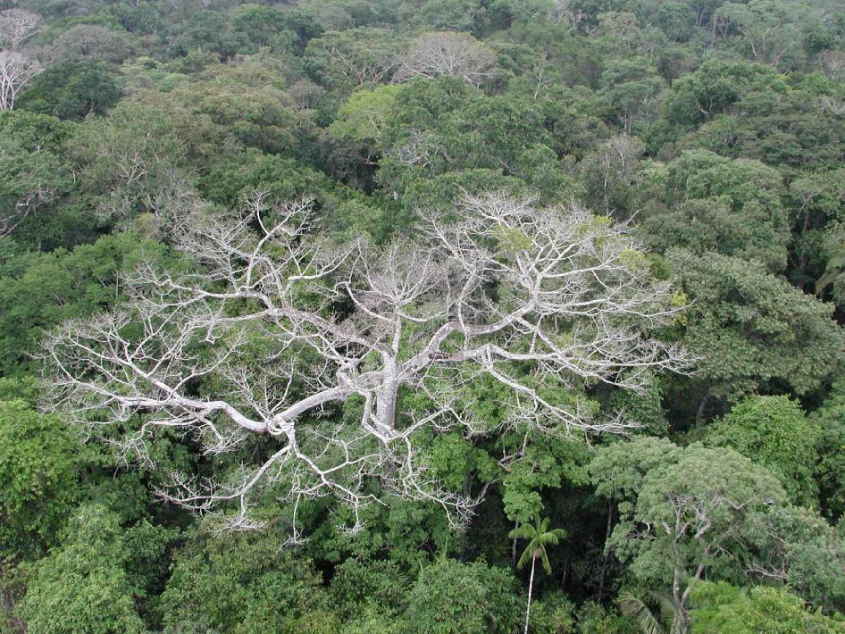
The scientists found that during the summer of 2005, more than 270,000 square miles (700,000 square kilometers, or 70 million hectares) of pristine, old-growth forest in southwestern Amazonia experienced an extensive, severe drought. This megadrought caused widespread changes to the forest canopy that were detectable by satellite. The changes suggest dieback of branches and tree falls, especially among the older, larger, more vulnerable canopy trees that blanket the forest.
While rainfall levels gradually recovered in subsequent years, the damage to the forest canopy persisted all the way to the next major drought, which began in 2010. About half the forest affected by the 2005 drought – an area the size of California – did not recover by the time QuikScat stopped gathering global data in November 2009 and before the start of a more extensive drought in 2010.
“The biggest surprise for us was that the effects appeared to persist for years after the 2005 drought,” said study co-author Yadvinder Malhi of the University of Oxford, United Kingdom. “We had expected the forest canopy to bounce back after a year with a new flush of leaf growth, but the damage appeared to persist right up to the subsequent drought in 2010.”
Recent Amazonian droughts have drawn attention to the vulnerability of tropical forests to climate change. Satellite and ground data have shown an increase in wildfires during drought years and tree die-offs following severe droughts. Until now, there had been no satellite-based assessment of the multi-year impacts of these droughts across all of Amazonia. Large-scale droughts can lead to sustained releases of carbon dioxide from decaying wood, affecting ecosystems and Earth’s carbon cycle.
The researchers attribute the 2005 Amazonian drought to the long-term warming of tropical Atlantic sea surface temperatures. “In effect, the same climate phenomenon that helped form hurricanes Katrina and Rita along U.S. southern coasts in 2005 also likely caused the severe drought in southwest Amazonia,” Saatchi said. “An extreme climate event caused the drought, which subsequently damaged the Amazonian trees.”
Saatchi said such megadroughts can have long-lasting effects on rainforest ecosystems. “Our results suggest that if droughts continue at five- to 10-year intervals or increase in frequency due to climate change, large areas of the Amazon forest are likely to be exposed to persistent effects of droughts and corresponding slow forest recovery,” he said. “This may alter the structure and function of Amazonian rainforest ecosystems.”
The team found that the area affected by the 2005 drought was much larger than scientists had previously predicted. About 30 percent (656,370 square miles, or 1.7 million square kilometers) of the Amazon basin’s total current forest area was affected, with more than five percent of the forest experiencing severe drought conditions. The 2010 drought affected nearly half of the entire Amazon forest, with nearly a fifth of it experiencing severe drought. More than 231,660 square miles (600,000 square kilometers) of the area affected by the 2005 drought were also affected by the 2010 drought. This “double whammy” by successive droughts suggests a potentially long-lasting and widespread effect on forests in southern and western Amazonia.
The drought rate in Amazonia during the past decade is unprecedented over the past century. In addition to the two major droughts in 2005 and 2010, the area has experienced several localized mini-droughts in recent years. Observations from ground stations show that rainfall over the southern Amazon rainforest declined by almost 3.2 percent per year in the period from 1970 to 1998. Climate analyses for the period from 1995 to 2005 show a steady decline in water availability for plants in the region. Together, these data suggest a decade of moderate water stress led up to the 2005 drought, helping trigger the large-scale forest damage seen following the 2005 drought.
Saatchi said the new study sheds new light on a major controversy that existed about how the Amazon forest responded following the 2005 megadrought. Previous studies using conventional optical satellite data produced contradictory results, likely due to the difficulty of correcting the optical data for interference by clouds and other atmospheric conditions.
In contrast, QuikScat’s scatterometer radar was able to see through the clouds and penetrate into the top few meters of vegetation, providing daily measurements of the forest canopy structure and estimates of how much water the forest contains. Areas of drought-damaged forest produced a lower radar signal than the signals collected over healthy forest areas, indicating either that the forest canopy is drier or it is less “rough” due to damage to or the death of canopy trees.
Fires raging unchecked in an Indonesian peat swamp forest could wipe out the remaining Sumatran orang-utans which live there, conservationists are warning. The forest is one of the last refuges of the great apes. The illegal fires, started by palm-oil companies clearing land to plant the lucrative crop, are believed to have killed at least 100 orang-utans – one-third of those living in the Tripa swamp, on the west coast of Sumatra’s Aceh province. The rest could die within weeks, according to Dr Ian Singleton, conservation director of the Sumatran Orang-utan Conservation Programme.
“The speed of destruction has gone up dramatically in the last few weeks… This is obviously a deliberate drive by these companies to clear all the remaining forests,” Dr Singleton said. “If this is not stopped right now, all those orang-utans… will be gone before the end of 2012.”
Only 6,600 Sumatran orang-utans are estimated to be left in the wild, and the Tripa swamp – where they are most densely concentrated – is considered crucial to the species’ survival. But less than one-quarter of the peat forest remains; the rest has been converted to palm-oil plantations.
Satellite imagery showing 92 fires over the past week has horrified conservationists, who are awaiting a court ruling with far-reaching implications for the protection of wildlife habitats in Indonesia. The judgment relates to a lawsuit brought against the governor of Aceh by the local branch of Walhi, an environmental group. Walhi decided to act after the governor, Irwandi Yusuf, granted a new permit to one of the country’s biggest palm-oil companies, PT Kallista Alam. Walhi Aceh argues that the permit, which would allow another 4,000 acres of peatland to be destroyed, was granted illegally.
The judges are due to reach a decision next Tuesday. If they dismiss the challenge, other important habitats could also be threatened. Tripa is nominally protected by a presidential moratorium on new logging and palm-oil concessions, as well as by legislation governing the conservation area within which it is located.
There may now be as few as 200 orang-utans left in the Tripa forest, which shelters a dozen endangered species, including the white-handed gibbon, clouded leopard, Malayan sun bear, Sumatran tiger and giant soft-shelled turtle.
Editor’s Note: Brave activist throughout the world risk their lives to protect the environment. We honor and respect their courage and realize that they are truly heroes. May they remain safe and in our thoughts to give them strength to carry on. Are you working with an organization that protects the environment?
Over nearly 30 years, Carlos Zorrilla and the organizations he co-founded helped stop six companies from developing open-pit copper mining operations in the Intag Valley in Ecuador. As a leader and public figure, Zorrilla is often for advice from communities facing similar struggles, so in 2009 he published a guide on how to protect one’s community from mining and other extractive operations. The 60-page guide shares wisdom and resources, including mines’ environmental and health risks, key early warning signs a company is moving in, and advice on mitigating damage if a mine does go ahead. The most important point, Zorrilla says in an interview with Mongabay, is to stop mining before it starts. Carlos Zorrilla is a leader in what locals say is the longest continuous resistance movement against mining in Latin America.
Zorrilla’s family fled from Cuba to the U.S. in 1962 when he was 11 years old. He moved to the Intag Valley in Ecuador in the 1970s, citing his love for the cloud forest ecosystem there. Soon after he arrived, so did the first of the mining companies.
Over the following decades, Zorrilla and the organizations he co-founded, including DECOIN (Defensa y Conservación Ecológica de Intag), helped block five transnational mining companies and a national company from developing operations in one of the planet’s most biodiverse ecosystems.
In the process, Zorrilla and community members say they faced personal threats, smear campaigns, arrests and violence. But the movement also notched historic wins, including a constitutional case upholding the rights of nature against Chilean state-owned miner Codelco and the Ecuadorian national mining company in 2023.
Community members holding a sign that says, “let’s save Intag.” Communities in Intag Valley have been resisting mining for nearly 30 years. Photo by Carlos Zorrilla.
As a leader and public figure, Zorrilla is often sought out for advice by people facing similar threats. In response, he and two co-authors published Protecting Your Community From Mining and Other Extractive Operations: A Guide for Resistance in 2009 and an updated version in 2016. (The guide is also available in Spanish, French and Bahasa Indonesian).
“After getting rid of two mining companies, I was constantly being asked how the hell we did it,” Zorrilla tells Mongabay. “Rather than keep answering individuals, I wrote the manual. It’s much easier to just say, ‘Read the manual!’”
The 60-page guide shares experiences and resources, including the environmental and health risks of mines, strategies to prevent mining before it starts, key early warning signs a company is moving in, and advice on mitigating damage if a mine goes ahead.
Zorrilla says the most important point is to stop mining before it starts. To emphasize this point, he also published Elements for Protecting Your Community from Mining and Other Extractive Industries, which focuses on preventing mining from gaining a foothold.
.
“Stop the companies before they corrupt your communities and before they discover economically viable mineral deposits,” he says. “Once they start investing in exploratory activities it becomes progressively harder to get rid of them.”
Mining is a divisive issue within Indigenous and local communities. Some see economic benefits to address poverty, own their own mining projects, and highlight the need to negotiate better benefit-sharing agreements or collaborations with mining projects as a form of self-determination.
“But these memorandums only work with ethical mining companies and they are as rare as chicken teeth,” Zorrilla says.
Zorrilla’s opinions on mining are contentious. After the publication of the resistance guide, Ecuador’s president at the time, Rafael Correa, denounced it on public television as “destabilizing” and a foreign-led interference, in a move that Zorrilla says was “great publicity for the manual.”
Former Ecuadorian President, Rafael Correa, holds up Zorrilla’s resistance guide on public television in 2009, denouncing it as “destabilizing”.
As the world transitions away from fossil fuels, the demand for critical minerals to feed “clean” energy technologies such as electric cars is rising. Thus, mining is also increasing.
However, many experts say mining in Ecuador, especially in the Intag Valley, is just a bad idea. Aside from the earthquakes, rainfall, steep slopes and lack of infrastructure, it’s a country with a wealth of other options for development, such as ecotourism potential or sustainable agriculture.
“It’s really a poor choice to develop large-scale mining in such a rich country,” says William Sacher, professor and researcher at Simón Bolívar Andean University in Quito, who studies large-scale mining and its impacts. “If you actually do the math just in terms of cost and benefit, if you take into account the costs of large-scale mining, they outweigh the benefits.”
Zorrilla’s work with DECOIN resisting mining as well as restoring forests and watersheds has been internationally recognized with awards, including the United Nations Development Programme’s Equator Prize in 2017. This year, Zorrilla won the Global Alliance for the Rights of Nature’s award for defending nature’s rights.
It’s his connection to nature, he says, that keeps him motivated. “It is hard to put into words the connection I feel with the land and people, with the biological community I am part of,” he says. “What else could someone do that feels to be an integral part of a community? How could one not defend it against forces that would destroy it?”
In an interview with Mongabay’s Liz Kimbrough, Zorrilla discusses the guide and his experiences.
An open pit copper mine in DRC. Image by Fairphone (CC BY S.A. 2.0)
Mongabay: What inspired you to write this guide?
Carlos Zorrilla: I think two main reasons motivated me to write the guide. The first and most important was that we had gone through a lot in confronting a Japanese and a Canadian mining company in the 1990s and the early 2000s and had to do so without any idea of how to go about it. I kept wishing there was some concrete information on the best ways for communities to confront the presence of these companies. Much as I looked around, I was unable to find anything.
I thought other communities could benefit from our experience in successfully standing up to two transnational mining corporations and blocking mining development in our area (as of early 2024, civil society in Intag has been able to block five transnational mining companies and a national one from opening a mine).
The second reason is much more practical. After getting rid of two mining companies, I was constantly being asked how the hell we did it. Rather than keep answering individuals, I wrote the manual. It’s much easier to just say, “Read the manual!”
Mongabay: You mention that preventing a project in the exploration phase is much easier than stopping it once mining has started. What are some early warning signs that communities should look out for?
Carlos Zorrilla: First, it helps to clarify why it’s so much more difficult to stop a mine once it has opened. A large mining company can incur hundreds of millions of dollars in exploration costs — costs that, in most cases, the country issuing the licenses could be held liable for if the mining company is unable to develop the mining site. This is a result of a country signing bilateral investment treaties with other countries to protect the investments of private companies.
So, in essence, the more a company invests in a project, the more expensive it is for a signatory country to pay off the mining company to go home.
The other reason is that the longer a mining company is a territory, the more likely they are to learn how to co-opt people and institutions, and they waste no time doing so. It’s similar to contracting cancer or other similar diseases: you’ve got to treat its soon as possible, otherwise it becomes deadly or ravages your body so badly that it becomes unable to defend itself.
Another reason it is imperative to stop a company in its initial stage or before is that the longer a mining company explores, the greater the possibility of finding an economically viable ore deposit. If they are successful, companies are much more likely to convince governments to allow all permits and look the other way in cases of illegal activities. It is also much easier for the company to find investors if they can show they have a viable mine to develop.
Mongabay: What are the first signs a company is interested in exploring territory?
Carlos Zorrilla: You may find strange people wandering around the community asking questions. Another is if you suddenly find that private individuals start to buy large tracts of land. Your community could be subjected to social and economic surveys carried out by a government agency under the guise of social or economic development or identifying health needs.
Keep in mind that it’s essential for the companies to find out as much as they can about the communities and the inhabitants they will be dealing with. This also goes for local government needs. For example, they may identify basic needs, such as the lack of basic health services, road and school infrastructure that needs repairing, lack of safe drinking water, etc. Once these needs are mapped out, they will offer the community and/or subnational governments financial help to address them. They often even offer to create so-called development groups or organizations, such as farming co-ops or women’s groups, and provide initial funding to address some of the needs. Companies may sign financial agreements with local or state governments to help cover the costs of supplying communities with basic necessities.
Needless to say, the funding always has strings attached to it, the least of which is that the subnational governments and community groups support the mining company’s presence and, later, the development of the mine.
The most important thing to remember is that the main objective of the companies is to create complete dependency on what they provide, whether it is jobs, road maintenance, drinking water, or basic health services. The inhabitants become so accustomed to having the services provided by the companies that they forget that they have lived without these things all their lives or that it is the state or national government’s responsibility to provide them. The dependency can become so instituted that the locals stop petitioning the local or national governments to provide the services and rely solely on the companies. This can also apply to subnational governments, especially when the national governments purposely reduce their funding as a strategy for the mining projects to gain support from the local populace.
At the same time, the companies are gathering basic information about the community, they are also identifying key players within the community. These are persons who have influence or could be groomed to hold a position of authority. They are the first ones co-opted. It could be someone successful in business or a well-respected community leader. They, in turn, will do a lot of the work for the company, such as convincing their neighbors that mining is the best way for the community and families to get out of poverty. Or it’s really silly not to accept the company’s support to build that road everyone always wanted. That propaganda is infinitely more effective when espoused by individuals you know and respect.
Community members in Intag protest mining in the forest. Image courtesy of Carlos Zorrilla.
Mongabay: What do you believe are some of the best ways to stop a mine before it starts?
Carlos Zorrilla: The best way to know what you’re up against is to find out all that you can about the company: things like who the owners are, the company’s history, main sources of funding, and where the company’s stocks are traded (if it is a publicly traded company).
Once you know all that you can about the company, your main objective is to stop it before it starts gathering information, hiring community members, or buying land — certainly before it holds meetings in your community.
As soon as you suspect a company is interested in your territory, hold public meetings or assemblies where, hopefully, most of the community’s adult population can participate in deciding whether to meet with the company. It can help to invite knowledgeable people to discuss some of the problems the community will have to face if they open the door to mining.
It is absolutely essential that no one accepts meetings with company officials or government employees promoting mining development unless it’s in a public setting with everyone from the community invited.
It is strongly recommended that the bylaws of the community include provisions for any approval of activities affecting the natural environment or social peace of the community be approved by two-thirds majority of the community members. It is dangerous to let the board members of the community (president, vice president, secretary, etc.) represent the community when it comes to allowing activities that could have such terrible and long-lasting social and environmental impacts.
Mongabay: The guide says mining companies use many tactics to divide communities and quell opposition. What’s the most difficult company tactic to counter that you’ve encountered? What should communities be aware of?
Carlos Zorrilla: The companies can use multiple tactics to neutralize the opposition. We’ve experienced just about all. Anywhere from making up criminal lawsuits to try to imprison effective opposition leaders and hiring paramilitaries to violently access the mining site, to death threats, outright buying community leaders, to terrible smear campaigns aimed at discrediting resistance leaders and/or the organizations that support the communities.
Then there are soft tactics. One of the hardest to counter is the easy money that the companies offer to the leaders and, eventually, community members when they start working for the company. This is especially effective in areas where making a living off the land is difficult.
Needless to say, this will lure people away from the fields and the normally hard work that is agriculture. Remember, the company offers steady paychecks, often accompanied by social security and health coverage. One of the things we must do is point out that these jobs will not last more than a few years or until the mine opens. Only qualified personnel are required once a mine opens, with few exceptions. But the company will never admit to it.
Communities have to know what the sacrifices are of accepting the jobs the companies offer. These include very often permanent, ongoing social conflicts; it could also lead to the relocation of whole communities to make room for the mine and its infrastructure, possibly contamination of water sources, desecrating sacred lands, and direct impacts on sustainable activities like ecotourism or agroecological farming.
It’s also been documented that there is more delinquency and violence surrounding mining projects, among many other negative impacts. The impacts are especially hard on women. Most mining jobs go to men, worsening economic inequality within households. Women often have to replace men’s work in the fields, adding even more stress to their daily lives. There also tends to be more health problems from STDs, plus more interfamily violence in mining sites.
So, when mining companies come offering jobs, communities have to consider all the impacts, not just look at the positive aspects.
That is why it is so important not to let the company get this far. Communities have to know that mining companies and government officials lie when it comes to convincing communities about mining. That is one of the most important messages. They have to lie because if they were to tell the truth about the social and environmental impacts of mining, not a single person in the community would support them.
In this light, it’s important to invite knowledgeable persons and community members from other communities that have suffered at the hands of mining companies to share with the communities what really goes on when mining companies roll into your community.
Liz Kimbrough is a staff writer for Mongabay and holds a Ph.D. in ecology and evolutionary biology from Tulane University, where she studied the microbiomes of trees. View more of her reporting here.
Five thousand acres of cloud forest are currently being threatened in Coatepec, Veracruz, Mexico. This land is, at present, being held by squatters, who, with the backing of local politicians, have claimed to be the forest’s rightful owners. They displaced dozens of families and are threatening one of Mexico’s most vital ecosystems. These 5,000 acres of land contain three municipal parks and one archeological site. While the land’s original stewards and forest protectors are engaged in a legal battle with the “invaders,” the deforestation of this fragile ecosystem has already commenced. This act of environmental devastation has wide political/economic ramifications. If you control Coatepec’s mountains, you control the subsistence and livelihood of millions.
The Coatepec Cloud Forest
The cloud forest above Coatepec is known as “la fabrica de agua” (the water factory). It is one of the last “water factories” of its kind in Mexico, and it moderates the weather of the entire region. The clouds that roll in from the Gulf of Mexico are captured by the forest canopy, the moisture forming a thick mist that shrouds the mountainside. Trees, moss, and orchids collaborate in an infinitely diverse ecosystem to retain the water that feed the region’s rivers, bringing life to the valleys bellow. The cities of Coatepec, Xalapa, and Cardel rely on this water, not to mention most of the communities of central Veracruz.
Globally, cloud forests are bastions of biodiversity. They harbor animal, and plant that are threatened by the shifting tides of the climate crises and uncontrolled land use. Coatepec’s cloud forest now hosts 90 plant, animal, and fungal species on the verge of extinction. Coupled with the biodiversity loss, the destruction of this ecosystem holds serious repercussions for the entire watershed. Without the cloud forest, the rivers will run dry, and the entire region will see considerably less rainfall. In short, the destruction of the cloud forest will spell drought and devastation for all.
The Invasion
In January 2019, a faction of the “Central Independiente de Obreros Agrícolas y Campesinos” (The Independent Organization of Agricultural Laborers and Farmers) set up an encampment on the 2,000 acres of cloud forest known as the Jinicuil Manso estate. CIOAC verbally threatened more than 500 original stewards of the land and claimed to be the legal owner of the property. While the information is difficult to corroborate, local activist networks say that the organizers of the CIOAC encampment came from outside the region, and do not hold legal rights to the said property. The community members who own land in the Jinicuil Manso estate submitted complaints to the local authorities. While the government “invited” the squatters to move off the premises, they requested that the community members refrain from engaging directly with CIOAC, to prevent physical aggression.
The situation was further complicated in February 2020, when the local authorities issued a “measurement and demarcation notice,” requesting that all the landowners submit paperwork confirming their title to the land. Many of the land’s stewards were not aware of the government’s decree. Others did not have the paperwork to prove that they owned their properties, even though the land had been in their family for generations. The local government never specified the reasons for this “demarcation notice,” and never compared the documents submitted by the land’s stewards with those provided by CIOAC. Instead, they refused to consider the documents submitted, and appear to favor CIOAC’s land claim, a land claim that local activists argue has been falsified.
The Electoral Politics of Water and Land
The local community groups, such as “Por la Defensa de la Sierra de Coatepec,” and the individual landowners, are currently involved in court cases with CIOAC. Throughout the process, it has it became clear the larger political forces are involved in the illegal “settlement” of the cloud forest. The CIOAC members have direct connection with major political parties in the area, with whom they have garnered ample political support. In addition, they have publicly thanked the governor of the State of Veracruz, Cuitlahuac García Jiménez, for his backing (though it is unclear whether this was just political posturing on the part of CIOAC).
Land, environmental destruction, and electoral politics has been devastatingly intertwined in Mexico for decades. When CIOAC first “invaded” the cloud forest, they invited citizens from the surrounding regions to squat on the appropriated land. Community members who did not own land of their own, and/or were seeking greater financial stability, settled in the cloud forest. Forest protectors have observed between 100 to 300 community members in the encampments at a time. They cut down trees, hunt the local fauna, and set up their septic systems to run off into the precious streams. When forest protectors attempt to plant trees or talk with the squatters, the squatters respond violently. They have been known to brandish guns and machetes, defending the land that has been promised to them.
Political figures from various parties in the region have sought to partner with the CIOAC settlers, nurturing a solid voting block of support. Leading up to the future regional and national elections, the ruling political parties have reacted favorably to the CIOAC’s land claims. However, underneath the surface, the forest protectors and activists claim that there is an even darker story. The people that live in the encampments of Jinicuil Manso could also be serving as a human shield, emptying the land for a larger economic interest that seeks to control the most vital resource of all: water.
The Conquest of the Cloud Forest
While at first glance the squatters could appear to be land hungry farmers, they are in fact just a cog in the virulent political system. Local activists believe that the squatters could be a facade for a political and economic interest that seeks to take over the forest of the region. Nestle, Coca-Cola, and other international corporations have huge factories in Coatepec, and have been seeking to control the region’s water supply for decades. Over the last series of elections, the community members have seen this same political/environmental ploy play out, though not to this level of devastation.
Veracruz is one the deadliest regions for land and water protectors in the world. “Por la Defensa de la Sierra de Coatepec” continues to organize throughout the region, raising awareness about the plight of the cloud forest, and the people that have been displaced. However, the settlers began threatening the lives of the forest protectors. When the organizers tried to negotiate with them in person, they were attacked with machetes. In the end, the CIAOC managed to scare most of the forest protectors into silence by actively threatening their families, while local authorities have turned a blind eye.
Action
While many forest protectors are too afraid to speak in public or to the press, the fight is not over. On the 29th of November 2020, “Por la Defensa de la Sierra de Coatepec” will return to the stolen land to begin reforesting the trees that have been cut down. They will also initiate a barter market with the local community members who have been directly affected by the theft of land. While many forest protectors have been forced to move to surrounding cities to protect their families, they are willing to risk their lives to defend and bring life back to the cloud forest.