by Deep Green Resistance News Service | Jun 27, 2012 | Biodiversity & Habitat Destruction, Toxification
By Claudia Adrien / University of Florida
The BP Deepwater Horizon oil spill temporarily worsened existing manmade problems in Louisiana’s salt marshes such as erosion, but there may be cause for optimism, according to a new study.
A study appearing online Monday in the Proceedings of the National Academy of Sciences found the 2010 spill killed off salt marsh plants 15 to 30 feet from the shoreline and this plant die off resulted in a more-than-doubled rate of erosion along the marsh edge and subsequent permanent marsh habitat loss. Vegetation farther from shore was relatively untouched by the incoming oil.
“Louisiana is already losing about a football field worth of wetlands every hour, and that was before the spill,” said Brian Silliman, a University of Florida biologist and lead author of the study. “When grasses die from heavy oiling, their roots, that hold the marsh sediment together, also often die. By killing grasses on the marsh shoreline, the spill pushed erosion rates on the marsh edge to more than double what they were before. Because Louisiana was already experiencing significant erosive marsh loss due to the channelization of the Mississippi, this is a big example of how multiple human stressors can have additive effects.”
Marshes are the life’s blood of coastal Louisiana because they act as critical nurseries for the shrimp, oysters and fish produced in these waters while helping to sequester significant amounts of carbon. They also protect coastlines from flooding and guard estuarine waters from nutrient pollution.
But the marshes have been suffering for decades as a result of the channelization of the Mississippi River, which has starved them from needed sediments to deter erosion.
Then came the oil spill.
Researchers observed minimal oil on the surfaces of grasses located more than 45 feet from the shoreline, indicating that significant amounts of oil did not move into interior marshes.
Instead, the researchers found that the tall grasses along the marsh edge acted as wall-like trap to incoming oil slicks, concentrating oil on the marsh edge. This concentration of oil on the shoreline protected interior marshes from oiling but worsened already extreme erosion on the shoreline. As oiled plants died, their roots that hold tight to the sediment perished as well. Already eroding sediment was now exposed to wave action without the effect of the gripping plant roots.
The result: elevated erosion rates for 1.5 years that averaged more than 10 feet of shoreline loss per year — double the natural rate for this area.
The encouraging results, Silliman said, included significant declines in the oil concentration on the marsh surface over 1.5 years and that unaffected, healthy marsh plants in the marsh interior quickly grew back into marsh die-off areas that had not yet been lost due to heightened erosion.
When the new marsh plant growth grew into the erosive edge of the marsh, Silliman said, the recolonization of the area by the gripping plant roots shut down the oil-elevated erosion rates and returned them to those seen at marsh sites where oil coverage did not occur.
The researchers also found that polyaromatic hydrocarbons, or PAHs, a carcinogenic byproduct of oil, was 100 percent greater at the Barateria Bay testing site than in reference marshes. This finding provides chemical evidence to support their visual observations that marshes in the affected areas were laden with oil while those in reference areas did not receive significant oiling.
By adding Biochar, a charcoal-based substance, to marshlands, Silliman’s team is also using new bioremediation tactics to try to break down PAHs into organic material. If this method is successful, he said, it could be used to supplement naturally occurring microbes in the marsh mud that already oxidize the oil carcinogen. The team is soon to publish those findings.
“This is a new idea applied toward cleaning up PAHs,” said UF chemistry professor Andrew R. Zimmerman, a co-author on the paper. “It’s possible there’s a bunch lurking at the bottom of the bay.”
From University of Florida News
by Deep Green Resistance News Service | Jun 26, 2012 | Climate Change, Obstruction & Occupation
By Candice Bernd / TruthOut
The deadline for the review of TransCanada’s permits for the Gulf Coast portion of the Keystone XL pipeline was Monday, June 25, 2012. At the Texas Army Corp of Engineers Galveston office and without any finalization of review, those permits will be automatically granted to the corporation – thanks to President Obama’s announcement that he would expedite the southern leg of the pipeline in Cushing, Oklahoma, back in March.
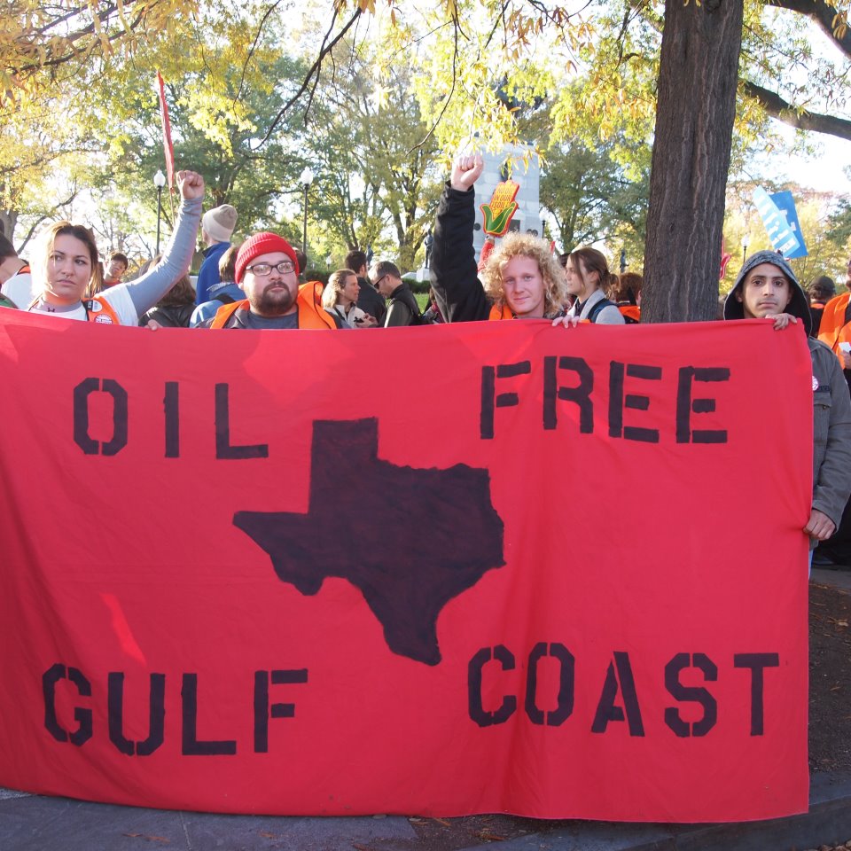
That’s why Texas climate justice activists, including myself, are officially announcing the Tar Sands Blockade, an epic action that we have been organizing since the beginning of the year. We’re mostly associated with Rising Tide North Texas, and we’re 100 percent prepared to use nonviolent, direct action to block the pipeline’s construction to protect our home.
Bring it, TransCanada
The Tar Sands Blockade will be coordinating nonviolent, direct actions along the pipeline route to stop this zombie pipeline once and for all. We are working with national allies as well as local communities to coordinate a road show that will travel throughout Texas and Oklahoma as well as a regional training effort for activists interested in getting involved in the blockade movement against the Keystone XL.
“Our action is giving a new meaning to ‘Don’t Mess with Texas,'” said Tar Sands Blockade Collective member Benjamin Kessler. Kessler is also a member of Iraq Veterans Against the War.
The permits for the pipeline’s construction are being automatically granted under the Nationwide Permit 12 protocol, or NWP 12. The permits do not need an environmental impact statement to accompany them, according to this process. That very fact alone endangers more than 631 streams and wetlands that the pipeline will cross in our state. Not only that, but the entire Carrizo-Wilcox Aquifer, which supplies drinking water for ten to 12 million homes across 60 counties in East Texas, along the pipeline’s path, is threatened with contamination.
The Keystone XL remains key to the expansion of the Alberta tar sands and leading NASA climate scientist James Hansen has called the pipeline “a fuse to the largest carbon bomb on the planet.” According to Hansen, if the carbon stored in the tar sands is released into the atmosphere, it would mean “game over for the climate.”
350.org founder Bill McKibben has worked hard to get Hansen’s message out to the public and to lawmakers in Washington. After more than 1,200 were arrested during the onset of the Tar Sands Action last fall, another 12,000 turned out to surround the White House to tell President Obama that the Keystone XL is not in the nation’s best interest.
McKibben was elated to hear that the Tar Sands Blockade is continuing to foster the spirit of resistance against the pipeline in the South with the use of nonviolent, direct action.
“Let’s be clear what the drama is here: human bodies and spirits up against the unlimited cash and political influence of the fossil fuel industry. We all should be grateful for this peaceful witness,” McKibben said.
Landowners living along the pipeline’s path say they have been intimidated by TransCanada to sign away the rights to their land, and it’s not just landowners that will lose. The pipeline is expected to destroy indigenous archeological and historical sites – including grave sites – in Oklahoma and Texas.
Read more from TruthOut: http://truth-out.org/news/item/9997-its-time-for-a-texas-tar-sands-blockade

by Deep Green Resistance News Service | Jun 20, 2012 | Biodiversity & Habitat Destruction
By The Wilderness Society
Today the U.S. House of Representatives passed a package of anti-wilderness bills (H.R. 2578), including H.R. 1505, the “National Security and Federal Lands Protection Act.”
H.R. 1505 would hand over “operational control” of federal public lands within 100 miles of the Canadian and Mexican borders to the U.S. border patrol, and could open national parks, wildlife refuges, wilderness and other public lands to development, such as construction and road building. Rep. Raul Grijalva’s (D, AZ-7) amendment to strike H.R. 1505 from the package was unfortunately defeated. This package of bills now awaits movement in the Senate.
Prior to the House vote, a coalition of Hispanic and immigration reform advocates, Native American tribal organizations, sportsmen, businesses and conservation groups, sent a letter to members of Congress voicing their opposition and asking members to vote against the bill.
“H.R. 1505 is an overreach that would adversely affect everyone who enjoys America’s public lands,” said David Moulton, senior legislative director at The Wilderness Society. “The bill would allow road building, construction and development on lands that are loved for hunting, fishing, hiking and other recreational activities. This vote was not in the best interest of the people who enjoy the land for its natural beauty.”
H.R. 1505 is part of an anti-wilderness package that includes, among other destructive bills:
• The Sealaska bill would give away tens of thousands of acres of high-value public land from the Tongass National Forest to the Sealaska Corporation. This would allow the corporation to clear-cut valuable forest land and take ownership of the best recreation sites at the heads of bays or mouths of salmon streams. This land giveaway would effectively prevent a long-planned transition out of old growth logging on the national forest, and privatize prime recreation spots that are currently open to the American public for fishing, hunting, and recreation and are relied upon by many small tourism, outfitter and fisheries businesses.
• Title XI, the “Grazing Improvement Act,” is a virtual giveaway of over 247 million acres of Bureau of Land Management (BLM) and National Forest rangelands to the approximately 27,000 livestock producers who have grazing privileges on the lands managed by these two agencies. The bill would change the term of federal livestock grazing leases from the current ten years to 20 years. No other government entity in the U.S. issues 20-year livestock grazing permits. In addition, Title XI reduces the level of environmental scrutiny of livestock grazing practices on BLM and National Forest lands by allowing these agencies to exempt the issuance of grazing permits from National Environmental Policy Act review.
• The Quincy Library Group bill would take an unsuccessful and outmoded forest management pilot program and expand it across much of northern California, while simultaneously authorizing logging in roadless areas, spotted owl habitat, salmon habitat and other areas of critical environmental importance and mandating minimum annual timber cuts.
Opposed by the Department of Homeland Security (DHS), H.R. 1505 could endanger personal freedoms by closing without notice our lands to hunting, fishing, tourism and recreation, all multi-million dollar industries that support small businesses. DHS Secretary Napolitano testified before Congress in opposition to H.R. 1505, saying it “is unnecessary, and it’s bad policy.” DHS benefits from their close collaboration with law enforcement counterparts in the land management agencies. In addition to threatening lands, the bill threatens this collaboration.
H.R. 1505 is an extreme and radical measure that would put at risk 49 million acres of public lands in 17 states, sweeping away 16 bedrock environmental and land management laws in Joshua Tree National Park, Boundary Waters Canoe Area Wilderness, Acadia National Park and any other protected land that sits within 100 miles of the border.
The Wilderness Society recently updated the report, “Wilderness Under Siege,” to reflect the movement of these and other bills and what they would mean to America’s lands, waters and natural legacy. Also mentioned in the report is H.R. 4089 — a Trojan horse bill that includes a sneak attack on wilderness. H.R. 4089 recently passed the House, and awaits passage in the Senate.
From The Wilderness Society: http://wilderness.org/content/land-grab-masked-national-security-measure-passes-us-house-representatives
Photo by CDC on Unsplash
by Deep Green Resistance News Service | May 24, 2012 | Biodiversity & Habitat Destruction, Indigenous Autonomy, Lobbying
By Ahni / Intercontinental Cry
A Federal judge has thrown out the Quechan Nation’s request for an injunction against the controversial Ocotillo Express Wind Project in western Imperial County, California.
The Quechan filed for the injunction on May 14, just three days after the Bureau of Land Management, an agency of the U.S. Department of the Interior, gave “fast-track” approval for the project. The Quechan complaint stated that the Department of Interior, in approving the project, “violated… federal laws, regulations, and policies including the Federal Land Policy and Management Act (FLPMA); National Historic Preservation Act (NHPA); National Environmental Policy Act (NEPA); Administrative Procedures Act (APA); and the CDCA [The California Desert Conservation Area] Plan.”
The complaint went on to explain that the massive 10,150-acre project area contains 287 archaeological sites including geoglyphs, petroglyphs, sleeping circles and other sites of spiritual significance; thousands of artifacts, and at least 12 burial (an exhaustive survey has not been carried out).
Construction of the 112-turbine project would utterly devastate these sites.
Furthermore, the project jeopardizes the delicate desert ecosystem which is “home to the Federally endangered Peninsular bighorn sheep and the flat-tailed horned lizard, a perennial candidate for listing under the Endangered Species Act,” says Chris Clarke, Director of Desert Biodiversity. “The turbines on the site would stand 450 feet tall with blades more than 180 feet long. With blades of that length, if the turbines spin at a leisurely 10 rpm the speed of the blade tips will approach 140 miles per hour, a serious threat to the region’s migratory birds — including the protected golden eagle,” he continues.
A day after filing for an injunction, on May 15, Quechan Tribal Council President Kenny Escalanti issued this statement outside the offices of Pattern Energy, the company behind the project.
He also spoke at a press conference alongside environmentalists and area residents in which he calls on President Obama to meet with tribal leaders and halt the destruction of sacred sites.
Robert Scheid, Viejas Band of the Kumeyaay Nation, spoke at the same press conference, calling on people across America to seek a national moratorium on industrial-scale energy projects on public lands. “Viejas leaders have asked to meet with President Barack Obama and Interior Secretary Ken Salazar”, reports East County Magazine “to share concerns over violations of laws that are supposed to protect tribal cultural resources; but have received no response”.
With the denial of the Quechan petition, Pattern Energy can now proceed with their construction plans without restraint. And they aren’t wasting any time. A new website documenting the daily destruction of the Ocotillo desert has just been launched: www.SaveOcotillo.picturepush.com.
If the construction is completed, the wind turbines will spin for no more than 30 years.
From Intercontinental Cry: http://intercontinentalcry.org/judge-denies-quechan-injunction-controversial-wind-project/
by Deep Green Resistance News Service | May 21, 2012 | Climate Change, NEWS
By Sara Reardon / New Scientist
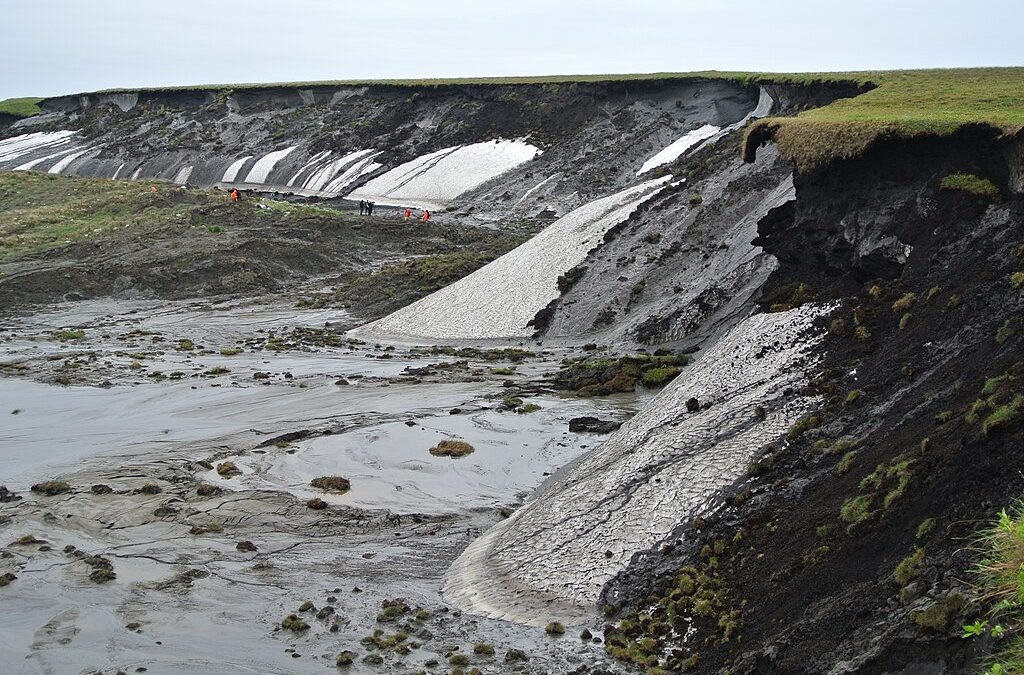
Melting Arctic permafrost could put even more methane – a potent greenhouse gas – into the atmosphere than previously thought, with worrying implications for the pace of global warming.
Many ice sheets that sit like caps over rock crevices trap natural seeps of methane; when they melt, the gas can quickly be released into the atmosphere in “burps”. Geologists have long suspected that iced-over geological structures might entrap vast stores of ancient methane that seep from coal and gas deposits, although no one knows exactly how much is there.
These stores, along with deep-water stores and shallow (more recent) deposits of decaying plant material in frozen soil, might open as the Arctic warms, releasing vast amounts of methane. Then, as the climate warms, more methane seeps could open and warming could accelerate.
During the winter, when Alaska was covered with ice, Katey Walter Anthony of the University of Alaska in Fairbanks and her colleagues flew planes over 6700 lakes in the state, looking for holes in the ice that might indicate lakes with methane seeps. They analysed gas from 50 holes and carbon-dated the methane leaking from them to determine the age of the gas. They did a similar survey of 25 lakes in Greenland.
Ancient gas
At boundaries where permafrost cover is melting or glaciers are retreating, the researchers found old methane, indicating that it came from deep in the Earth and is only now being released. The team then created a model that extrapolated where these natural pockets would be located in lakes throughout Alaska. They found the likeliest locations at the edges of ice sheets.
The team estimate that Alaska is emitting 50 to 70 per cent more methane into the atmosphere than previously thought. Geological records indicate that the model would also apply to deep methane stores in Canada and Siberia, currently covered by ice.
Walter Anthony says that the presence of oil and gas in the Antarctic indicates it may hold ancient methane as well. “This is a far more nuanced study than has been done,” says Carolyn Ruppel of the US Geological Survey in Woods Hole, Massachusetts. Although she praises Walter Anthony’s modeling work, she points out that extrapolating the findings to draw conclusions about methane seeps on other continents is very difficult.
Any release of it could accelerate warming at the poles and speed the entire process, Walter Anthony says, but it’s hard to predict exactly how soon this could happen. To answer this, her group plans to look at how methane is captured and stored in permafrost, and the pattern in which it melts.
From New Scientist
Boris Radosavljevic, CC BY 2.0 <https://creativecommons.org/licenses/by/2.0>, via Wikimedia Commons