The Green Revolution is a misnomer: it sounds like a radical environmental movement when it’s the exact opposite of that. It is a movement led by corporations (including the Ford Foundation and the Rockefeller Foundation) to further reinforce the class-based heierarchy, while spreading an ecocidal practice across the world.
The Green Revolution has promoted the use of synthetic fertilizers and pesticides; hybridized seeds and high yielding crop varieties; expansion of irrigation infrastructure, and modernization of management techniques. It started in late 1950s and has been credited as the movement that saved the world from mass starvation. (The mass starvation seemed imminent due to the human population overshoot. The population was 3 billion at the time and since then has increased by more than 5 billion – an almost threefold increase!) Norman Borlaug, the father of Green Revolution, was awarded the Nobel Peace Prize in 1970 for saving a billion people from starvation.
Currently a second wave of Green Revolution is on the way. Influential people like Bill Gates are pushing the use of Genetically Modified Crops (GMOs) in countries of Africa as a new solution to the upcoming starvation.
This is the dominant narrative regarding the Green Revolution. There are some important points missing from this perfect little story.
Lets delve into the history of the agricorporations first.
The agricultural corporations have an intertwined history history with the wars. During World War II, the agricultural corporations (then chemical corporations) produced explosives and poisons. Monsanto operation the Dayton Project and the Mound Laboratories, and was involved in the development of the first nuclear weapons. During the Vietnam War, Monsanto also poisoned Vietnam, Cambodia and Laos with Agent Orange. The effects on human health and ecology can be felt to this day.
The war legacy of these corporations extends beyond this. According to the Nuremberg War Crimes Tribunals, Bayer had purchased 150 healthy women from the Auswitch concentration camp for experiments with sleep-inducing drugs. All of these women died during the experiments.
It is hard to believe that the companies that had no qualms in actively profiteering from wars, conducting war crimes, or purchasing humans, would simultaneously be sensitive to the sufferings of humanity. These corporations have proven time and again that they are willing to poison and exploit the oppressed (the poor, the women, those from the Global South) in pursuit of profit. It is ironical that proponents of GMOs use images of starving children in Africa to build a case in favor of these corporations.
Lets take a case of the state of Punjab in India.
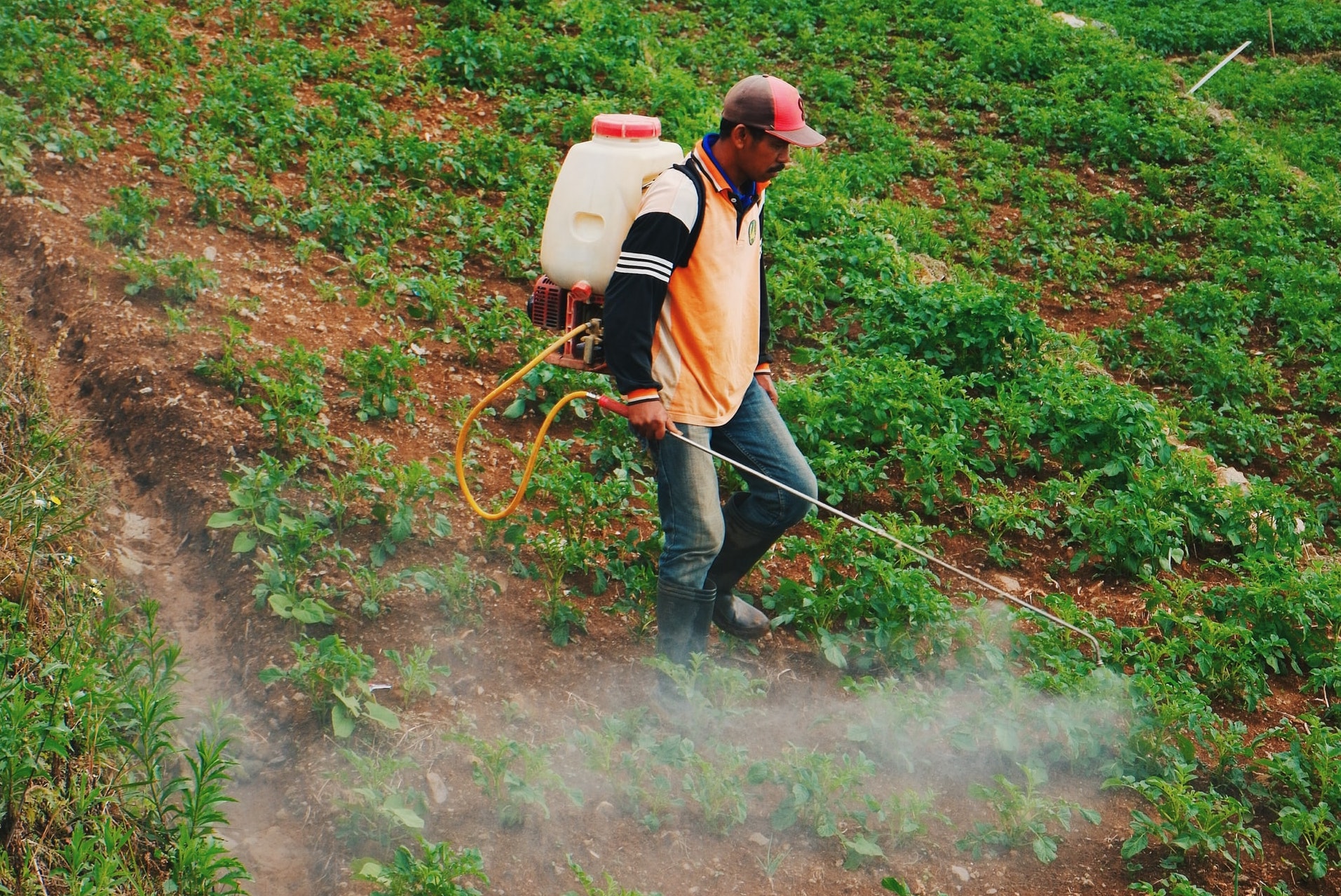
The Green Revolution was introduced in Punjab in 1965. It has been credited for pulling India out of starvation.
In reality, there was no starvation in India in 1965.* A nationwide drought had increased the food prices, creating a need to import food grains. However, the US government and the World Band imposed a condition on the import of food grains and forced synthetic fertilizers and pesticides, and genetically redesigned crops to the farmers of Punjab. These synthetic fertilizers and pesticides were produced using the same chemicals that had been used to produce poisons and explosives during the Second World War. Native crops all over rejected these chemicals. So, the agriculture corporations genetically altered crops so that they would accept (and be dependent on) the synthetic chemicals. These crops later became known as the high yielding varieties and the hybridized seeds.
The Green Revolution has had serious implications in Punjab. The native biodiversity has been destroyed. Once, Punjab used to produce 41 varieties of wheat and 37 varieties of rice. Since the Green Revolution, all of this has been replaced by monocultures of imported crops.
These crops require further use of chemicals. It has toxified the entire ecology. A 2014 study found pesticide residue in 25% of breast milk sample collected from Punjab. In a culture where breast milk stands for purity and love of a mother for her child, a quarter of mothers cannot express this love toward their infants without simultaneously poisoning them.
The number cancer cases are so high in Punjab that a special train carries people suffering from pesticide-related cancer to Rajasthan (another state in India). This train is called the “cancer train.”
Technology transfer or wealth transfer?
The Green Revolution has been credited for technology transfer from the corporations to the farmers. In fact, it has resulted in a massive wealth transfer from farmers to corporations. The farmers in India are dying from an inability to pay the massive loans they have accrued. Since the 1990s, farmers suicide has been a national catastrophe in India. It is estimated that more than 10 farmers commit suicide every day. Ironically, or perhaps symbolically, most kill themselves on their fields by drinking pesticides.
I was once asked why the movement is called the Green Revolution. I said, “Because poison-your-land movement would have sounded less appealing.” It would definitely have been more accurate though!
Stop Thinning Forests is a community compilation, sponsored by Deep Green Resistance, of research and voices that speak in defense of our forests against the atrocities that are being committed on those communities in the name of “fire mitigation” and “forest health.”
The Forest Service, in partnership with the timber industry, uses propaganda to promote the idea that thinning helps lessen fire severity while improving forest health. The research on the benefits of forest thinning is financially backed by the timber industry, and congressional passing of bills that promote thinning are backed by the lobbying efforts of the industry. The main goal for thinning forests is to increase revenue by allowing the timber industry to get into forests that were previously protected by environmental laws. Recent legislation has allowed the industry to bypass those laws and profit from forest products in the name of “forest health and restoration.” The Forest Service has consistently worked with the timber industry as a result of financial incentives and has been responsible for creating the infrastructure through use of federal tax dollars in the form of subsidies that enable the industry to “get the cut out.”
Individual land owners have recently been encouraged by the Forest Service to thin their lands with available grant monies under the guise of protecting their homes from fire and to improve the health of the forests. The available grant money filters down to the Forest Service from federal legislation that allows industry to get into our treasured, and last remaining, intact forests. Thinning private lands is offered as another incentive that generates money for the Forest Service while creating the appearance that the Forest Service is promoting a policy of “fire mitigation” and “forest restoration,” extending to the wildland/urban interface. Private land owners have the power to become informed and make rational decisions to protect their homes from fire that will not devastate the forest community. It is essential that individuals making these decisions become informed about federal forest policies and the history of the Forest Service before making decisions that will disrupt and harm the forest communities where we live.
Here is a recent on-the-ground report back from Deanna Meyer, a Deep Green Resistance organizer in Colorado:
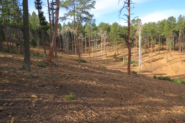
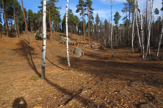
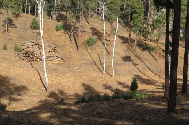
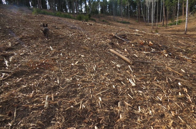
I went up to check on my neighboring forest who is being destroyed as I write with heavy equipment. These photos show some of the results. Pictures could never show the true devastation, and this place, which is very important to me, is now unrecognizable.
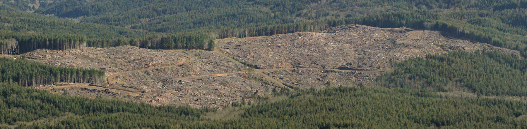
This is at a church in Sedalia, Colorado and this tax exempt church accepted hundreds of thousands of tax payers’ dollars to destroy this forest. All of this is in the name of “fire prevention.” Research analyzing millions of acres throughout the West where fires have occurred shows otherwise.
Here in Colorado, all we need to do is look at the 3 largest fires in our history, all occurring this year, and pay attention to all of the acres that were “thinned” just like this. They did NOT fare any better than the untouched forests and in many areas they burnt even faster and hotter because of wind breaks and dried out soil.
All of this is horrific and heartbreaking, but the soil stands out the most to me. It takes thousands of years to create healthy soil and mycelial networks. This land now is a barren dustbowl with some wood chips thrown on top. The mycelium, grasses, sedges, forbs, and trees who were there and holding the soil together are now completely obliterated from the heavy equipment, mulching and utter destruction of at least a foot of soil who used to be sinking carbon and healing the land.
Every time our forests start to heal themselves from the decades of colonizing destruction, the Forest DISservice and private land owners come in and log it again. When you look at the forests that have not been touched for decades, they are healing and thinning themselves out. Just because they look “messy” to colonizers who can’t stand the idea of not having control over every living biome that exists does not alter the fact that the forests know best what to do with themselves and our meddling with them is biocide.
“We do not want those whose first impulse is to compromise. We want no straddlers, for, in the past, they have surrendered too much good wilderness and primeval areas which should never have been lost.“
Mr. Wuerthner provides a long list of key conservation victories, including the Arctic National Wildlife Refuge (ANWR), Yellowstone, Grand Teton, and Olympic National Park – all of which were protected because heroic people refused to compromise. He cites notable failures, as well, writing:
“Pragmatists, in the end, leave messes for future generations to clean up. Capitulating to local interests with half-baked compromises in the interest of expediency typically produces uneven results. Either they do not adequately protect the land or create enormous headaches for future conservationists to undue often at a significant political and economic expense.“
The National Forests system was originally set up by President Theodore Roosevelt to protect forests from commercial activity – not log them. Compromises made by Gifford Pinchot, the first Chief of the Forest Service, resulted in mining companies (and later timber companies) gaining access to our National Forests. In the early 1900’s, almost no one could imagine that the seemingly limitless supply of virgin timber on private lands would one day be exhausted. They could not conceive that in a few generations’ time, timber companies and their partners in government agencies would be fighting tooth and nail to log the dwindling amount of old growth in our national forests – our collective natural heritage.
Lessons for the Elliott Mr. Wuerthner’s impassioned writing has left me wondering what lessons future generations will glean from the current process surrounding the Elliott State Forest (likely to be handed over to OSU with their timber-centric “research design” in the coming weeks). How will they see the unusually short public outreach/comment period and the rush to complete the OSU plan in time for the Land Board’s approval? How will they judge our mainstream environmental groups who seem afraid to openly criticize the egregious shortcomings of the plan and process? Will future Oregonians accept that compromise was the best we could hope for with the Elliott State Forest?
Insight from the Advisory Committee: In a recent email, Bob Sallinger (Portland Audubon member serving on the Advisory Committee) clarified the current situation with OSU’s draft plan for the Elliott:
“The draft plan calls for cutting up to 3287 acres of mature forest (between 65 and 152 years of age) over a period of a couple or two decades using selective harvest (20%-80% retention). Several hundred acres within this 3287 acres are on the younger side (65-100 years old) but the majority is in 100-152 year range…
I don’t think there is anybody in the conservation community that thinks it is a good idea to cut these older stands or that the research benefits outweigh the benefits of preserving 100% of the older stands…Ultimately the question the conservation community will need to decide is whether they can live with the tradeoffs in this plan…
Pretty much 100% of the changes and concessions over the past year have been made to address conservation concerns. Despite that fact, if conservation interests sign-off, it looks like we will have consensus among all stakeholders including tribes, timber, counties, hunters and rec, and schools…
So bottom line is that there are definitely tradeoffs in this plan. There would be under any management scenario. In a perfect world we would lock up the entire Elliott as a carbon/ biodiversity reserve. However the same issues that have necessitated a decades long battle over the Elliott are still in play today.
Folks will have to decide whether the inclusion of things like clearcuts in about 14,000 acres of existing plantations (under 65 years of age) or selective harvest in a limited number of stands >65 are deal breakers or not. In doing so, I would encourage folks to think carefully about the other pathways that are available to us.“
I have great respect for Bob. He has been a true conservation hero on the Advisory Committee. But the 12-member committee was compromised at the outset by the inclusion of hardliners with vested economic interests (Douglas County Commissioner Chris Boice is a great example). When Bob writes about the need to live with tradeoffs and reach consensus among all stakeholders, I wonder what happened to the broader group of stakeholders – the citizens of Oregon. I also wonder why experts in forest ecology and carbon were not included on the committee – while timber interests were.
When it comes to the fate of the Elliott, surveys show Oregonians overwhelmingly support conservation. When I see DSL and the Land Board showing such great deference to OSU, I wonder, “Where’s the deference to Oregonians?” When it comes to this state forest, one ought to defer to the citizens of this state. And when it comes to compromise and tradeoffs, one has only to look at the millions of acres of clearcuts in our state and federal forests to understand that we’ve already compromised our natural heritage.
Pictures Tell the Story: OSU’s latest draft plan for the Elliott State Research Forest (ESRF) is an unwieldy mix of contradictions, obfuscation, and technical jargon put together by folks who clearly are not adept at communicating with a broader audience. When it comes to understanding this fundamental issue of compromise in the Elliott, pictures are the key.
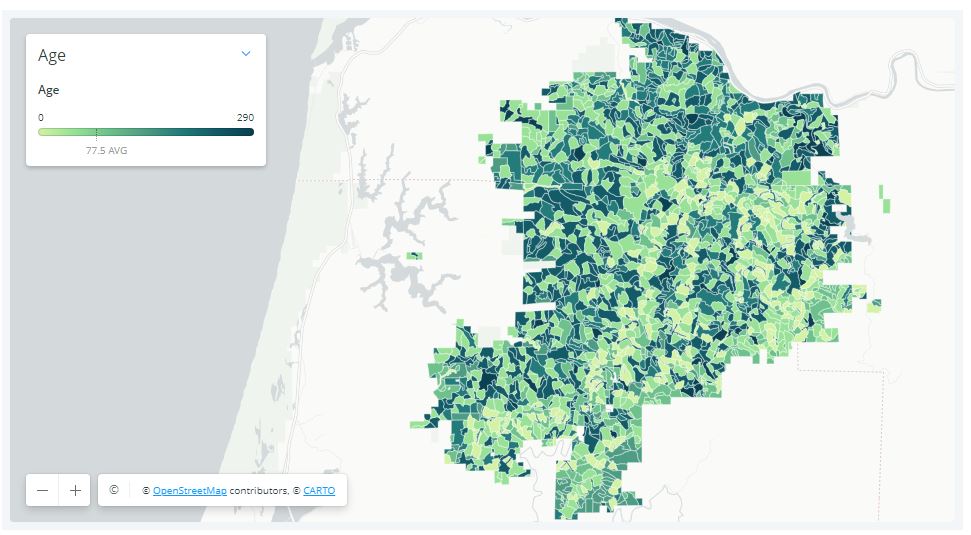
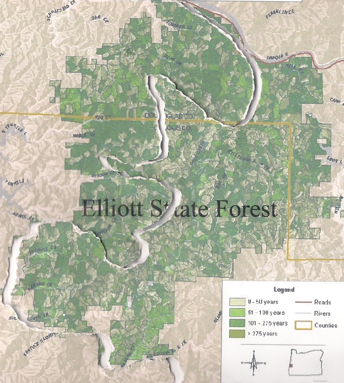
The map below shows the locations of older trees (indicated by darker shades of green) in the Elliott State Forest. It is important to note that significant quantities of older trees are scattered across vast stretches of the Forest.
Tree age classes in the Elliott State Forest (darker = older)
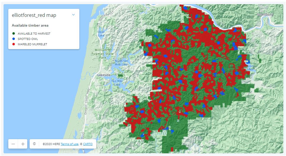
This next map shows the habitat of threatened birds (marbled murrelet in red and northern spotted owls in blue) in the Elliott. Predictably, the habitat is closely aligned with the older stands.
Habitat for threatened birds in the Elliott State Forest
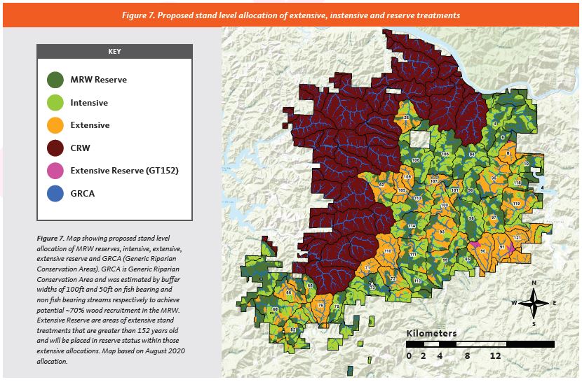
This final map shows how the OSU would divide the forest. The purple areas (denoted as “CRW”) would be “conservation research watersheds”, with limited logging allowed. The dark green areas (labeled as “MRW Reserve”) will be subject to experimental treatments (= logging) in the coming decades. The orange areas (labeled “Extensive”) will undergo thinning in which 20-80% of the trees are to be cut (including thousands of acres of older trees). The light green areas (labeled “Intensive”) are composed of trees less than 65 years of age, and will be subject to clearcutting.
OSU’s research design for the Elliott would perpetuate clearcutting or fragmentation in well over half the forest (conservation reserves shown in purple)
Viewed from the perspective of older trees and habit for our threatened birds, OSU’s plan for the Elliott is a complete disconnect. As the maps clearly show, it would sacrifice a majority of the Forest to continued clearcutting and fragmentation.
George Wuerthner’s eloquent words could not be more applicable to the Elliott:
“In far too many cases, there is a tendency to believe that it is necessary to appease local interests typically by agreeing to weakened protections or resource giveaways to garner the required political support for a successful conservation effort. However, this fails to consider that in nearly all cases where effective protective measures are enacted, it has been done over almost uniform local opposition.
In those instances where local opposition to a conservation measure is mild or does not exist, it probably means the proposal will be ineffective or worse—even set real conservation backward…Nevertheless, many environmentalists now believe that due to regional parochialism and lack of historical context, significant compromises are necessary to win approval for new conservation initiatives.“
The Elliott State Forest has already been heavily compromised – OSU’s plan would perpetuate the mistakes of the past.
The essence of OSU’s plan for the Elliott – the area on the west side would be protected, the area to the east would face continued fragmentation via a complicated matrix of “forest management” (including ~14,000 acres of clearcutting).
“You cannot live a political life, you cannot live a moral life if you’re not willing to open your eyes and see the world more clearly. See some of the injustice that’s going on. Try to make yourself aware of what’s happening in the world. And when you are aware, you have a responsibility to act.”
—Bill Ayers, cofounder of the Weather Underground.
A black tern weighs barely two ounces. On energy reserves less than a small bag of M&M’s and wings that stretch to cover twelve inches, she flies thousands of miles, searching for the wetlands that will harbor her young. Every year the journey gets longer as the wetlands are desiccated for human demands. Every year the tern, desperate and hungry, loses, while civilization, endless and sanguineous, wins.
A polar bear should weigh 650 pounds. Her energy reserves are meant to see her through nine long months of dark, denned gestation, and then lactation, when she will give up her dwindling stores to the needy mouths of her species’ future. But in some areas, the female’s weight before hibernation has already dropped from 650 to 507 pounds. Meanwhile, the ice has evaporated like the wetlands. When she wakes, the waters will stretch impassably open, and there is no Abrahamic god of bears to part them for her.
The Aldabra snail should weigh something, but all that’s left to weigh are skeletons, bits of orange and indigo shells. The snail has been declared not just extinct, but the first casualty of global warming. In dry periods, the snail hibernated. The young of any species are always more vulnerable, as they have no reserves from which to draw. In this case, the adults’ “reproductive success” was a “complete failure.” In plain terms, the babies died and kept dying, and a species millions of years old is now a pile of shell fragments.
What is your personal carrying capacity for grief, rage, despair?
We are living in a period of mass extinction. The numbers stand at 200 species a day. That’s 73,000 a year. This culture is oblivious to their passing, feels entitled to their every last niche, and there is no roll call on the nightly news.
There is a name for the tsunami wave of extermination: the Holocene extinction event. There’s no asteroid this time, only human behavior, behavior that we could choose to stop. Adolph Eichman’s excuse was that no one told him that the concentration camps were wrong. We’ve all seen the pictures of the drowning polar bears. Are we so ethically numb that we need to be told this is wrong?
There are voices raised in concern, even anguish, at the plight of the earth, the rending of its species. “Only zero emissions can prevent a warmer planet,” one pair of climatologists declare. James Lovelock, originator of the Gaia hypothesis, states bluntly that global warming has passed the tipping point, carbon offsetting is a joke, and “individual lifestyle adjustments” are “a deluded fantasy.” It’s all true, and self-evident.
“Simple living” should start with simple observation: if burning fossil fuels will kill the planet, then stop burning them.
But that conclusion, in all its stark clarity, is not the popular one to draw. The moment policy makers and environmental groups start offering solutions is the exact moment when they stop telling the truth, inconvenient or otherwise. Google “global warming solutions.” The first paid sponsor, Campaign Earth, urges “No doom and gloom!! When was the last time depression got you really motivated? We’re here to inspire realistic action steps and stories of success.” By “realistic” they don’t mean solutions that actually match the scale of the problem. They mean the usual consumer choices—cloth shopping bags, travel mugs, and misguided dietary advice—which will do exactly nothing to disrupt the troika of industrialization, capitalism, and patriarchy that is skinning the planet alive.
As Derrick has pointed out elsewhere, even if every American took every single action suggested by Al Gore it would only reduce greenhouse gas emissions by 21 percent. Aric tells a stark truth: even if through simple living and rigorous recycling you stopped your own average American’s annual one ton of garbage production, “your per capita share of the industrial waste produced in the US is still almost twenty-six tons. That’s thirty-seven times as much waste as you were able to save by eliminating a full 100 percent of your personal waste.”
Industrialism itself is what has to stop.
There is no kinder, greener version that will do the trick of leaving us a living planet. In blunt terms, industrialization is a process of taking entire communities of living beings and turning them into commodities and dead zones. Could it be done more “efficiently”? Sure, we could use a little less fossil fuels, but it still ends in the same wastelands of land, water, and sky. We could stretch this endgame out another twenty years, but the planet still dies. Trace every industrial artifact back to its source—which isn’t hard, as they all leave trails of blood—and you find the same devastation: mining, clear-cuts, dams, agriculture. And now tar sands, mountaintop removal, wind farms (which might better be called dead bird and bat farms).
No amount of renewables is going to make up for the fossil fuels or change the nature of the extraction, both of which are prerequisites for this way of life. Neither fossil fuels nor extracted substances will ever be sustainable; by definition, they will run out. Bringing a cloth shopping bag to the store, even if you walk there in your Global Warming Flip-Flops, will not stop the tar sands. But since these actions also won’t disrupt anyone’s life, they’re declared both realistic and successful.
The next site’s Take Action page includes the usual: buying light bulbs, inflating tires, filling dishwashers, shortening showers, and rearranging the deck chairs. It also offers the ever-crucial Global Warming Bracelets and, more importantly, Flip-Flops. Polar bears everywhere are weeping with relief.
The first noncommercial site is the Union of Concerned Scientists. As one might expect, there are no exclamation points, but instead a statement that “[t]he burning of fossil fuel (oil, coal, and natural gas) alone counts for about 75 percent of annual CO2 emissions.” This is followed by a list of Five Sensible Steps. Step One? No, not stop burning fossil fuels—“Make Better Cars and SUVs.” Never mind that the automobile itself is the pollution, with its demands—for space, for speed, for fuel—in complete opposition to the needs of both a viable human community and a living planet. Like all the others, the scientists refuse to call industrial civilization into question. We can have a living planet and the consumption that’s killing the planet, can’t we?
The principle here is very simple.
As Derrick has written, “[A]ny social system based on the use of nonrenewable resources is by definition unsustainable.” Just to be clear, nonrenewable means it will eventually run out. Once you’ve grasped that intellectual complexity, you can move on to the next level. “Any culture based on the nonrenewable use of renewable resources is just as unsustainable.” Trees are renewable. But if we use them faster than they can grow, the forest will turn to desert. Which is precisely what civilization has been doing for its 10,000 year campaign, running through soil, rivers, and forests as well as metal, coal, and oil. Now the oceans are almost dead and their plankton populations are collapsing, populations that both feed the life of the oceans and create oxygen for the planet.
What will we fill our lungs with when they are gone? The plastics with which industrial civilization is replacing them? In parts of the Pacific, plastic outweighs plankton 48 to 1. Imagine if it were your blood, your heart, crammed with toxic materials—not just chemicals, but physical gunk—until there was ten times more of it than you. What metaphor is adequate for the dying plankton? Cancer? Suffocation? Crucifixion?
But the oceans don’t need our metaphors. They need action. They need industrial civilization to stop destroying and devouring. In other words, they need us to make it stop.
Which is why we are writing this book.
THE DEEP GREEN RESISTANCE BOOK
Strategy to Save the Planet:
In June 2019, in response to media outcry and alarm over a supposed ongoing global “Insect Apocalypse,” Mongabay published a thorough four-part survey on the state of the world’s insect species and their populations.
In four, in-depth stories, science writer Jeremy Hance interviewed 24 leading entomologists and other scientists on six continents and working in 12 nations to get their expert views on the rate of insect decline in Europe, the U.S., and especially the tropics, including Latin America, Africa, and Australia.
Now, 16 months later, Hance reaches out to seven of those scientists to see what’s new. He finds much bad news: butterflies in Ohio declining by 2% per year, 94% of wild bee interactions with native plants lost in New England, and grasshopper abundance falling by 30% in a protected Kansas grassland over 20 years.
Scientists say such losses aren’t surprising; what’s alarming is our inaction. One researcher concludes: “Real insect conservation would mean conserving large whole ecosystems both from the point source attacks, AND the overall blanket of climate change and six billion more people on the planet than there should be.”
In the middle of the COVID-19 pandemic, in the heart of a what was increasingly a global lockdown, the rains finally came to East Africa. They came after several years of drought and less-than-stellar rainy seasons. And with these rains, came the insects, says Dino Joseph Martins, the executive director of the Mpala Research Center. “There’s been this beautiful flash of butterflies and everybody’s with their families or at home, or trying to entertain their kids that are not in school, and looking at things in the garden or going on walks,” Martins said in August.
Martins, an entomologist and butterfly aficionado, has become so “inundated” by questions from curious insect onlookers in lockdown that he’s considering “quitting social media” just to have some time to breathe again.
“I think there has been a much broader appreciation of nature [during the pandemic] and it’s because of the loneliness of lockdown, the isolation,” says Martins. “This has been such a blow for so many people.” But, according to the scientist, the pandemic has also unexpectedly awakened many people to the marvels of the natural world and our interconnectedness with it.
It’s a happy anecdote in a year that has seen not only wrenching global change due to the pandemic, but also reams of new research on the potential decline of insects around the world, often dubbed more dramatically as the “insect apocalypse” by the media.
New data fills out increasingly complex global picture
A year after publishing Mongabay’s June 2019 series The Great Insect Dying, I reached out again to some of my scientific sources to see how they viewed new findings across the previous twelve months. None of the seven researchers I spoke with expressed a major shift in their well informed views, which ranged from concern over regional declines, to a wider belief that global insect diversity and abundance may be gravely in trouble.
This article was written by Jeremy Hance and published in Mongabay on the on 11 November 2020. You can read the full, original article here:
Five thousand acres of cloud forest are currently being threatened in Coatepec, Veracruz, Mexico. This land is, at present, being held by squatters, who, with the backing of local politicians, have claimed to be the forest’s rightful owners. They displaced dozens of families and are threatening one of Mexico’s most vital ecosystems. These 5,000 acres of land contain three municipal parks and one archeological site. While the land’s original stewards and forest protectors are engaged in a legal battle with the “invaders,” the deforestation of this fragile ecosystem has already commenced. This act of environmental devastation has wide political/economic ramifications. If you control Coatepec’s mountains, you control the subsistence and livelihood of millions.
The Coatepec Cloud Forest
The cloud forest above Coatepec is known as “la fabrica de agua” (the water factory). It is one of the last “water factories” of its kind in Mexico, and it moderates the weather of the entire region. The clouds that roll in from the Gulf of Mexico are captured by the forest canopy, the moisture forming a thick mist that shrouds the mountainside. Trees, moss, and orchids collaborate in an infinitely diverse ecosystem to retain the water that feed the region’s rivers, bringing life to the valleys bellow. The cities of Coatepec, Xalapa, and Cardel rely on this water, not to mention most of the communities of central Veracruz.
Globally, cloud forests are bastions of biodiversity. They harbor animal, and plant that are threatened by the shifting tides of the climate crises and uncontrolled land use. Coatepec’s cloud forest now hosts 90 plant, animal, and fungal species on the verge of extinction. Coupled with the biodiversity loss, the destruction of this ecosystem holds serious repercussions for the entire watershed. Without the cloud forest, the rivers will run dry, and the entire region will see considerably less rainfall. In short, the destruction of the cloud forest will spell drought and devastation for all.
The Invasion
In January 2019, a faction of the “Central Independiente de Obreros Agrícolas y Campesinos” (The Independent Organization of Agricultural Laborers and Farmers) set up an encampment on the 2,000 acres of cloud forest known as the Jinicuil Manso estate. CIOAC verbally threatened more than 500 original stewards of the land and claimed to be the legal owner of the property. While the information is difficult to corroborate, local activist networks say that the organizers of the CIOAC encampment came from outside the region, and do not hold legal rights to the said property. The community members who own land in the Jinicuil Manso estate submitted complaints to the local authorities. While the government “invited” the squatters to move off the premises, they requested that the community members refrain from engaging directly with CIOAC, to prevent physical aggression.
The situation was further complicated in February 2020, when the local authorities issued a “measurement and demarcation notice,” requesting that all the landowners submit paperwork confirming their title to the land. Many of the land’s stewards were not aware of the government’s decree. Others did not have the paperwork to prove that they owned their properties, even though the land had been in their family for generations. The local government never specified the reasons for this “demarcation notice,” and never compared the documents submitted by the land’s stewards with those provided by CIOAC. Instead, they refused to consider the documents submitted, and appear to favor CIOAC’s land claim, a land claim that local activists argue has been falsified.
The Electoral Politics of Water and Land
The local community groups, such as “Por la Defensa de la Sierra de Coatepec,” and the individual landowners, are currently involved in court cases with CIOAC. Throughout the process, it has it became clear the larger political forces are involved in the illegal “settlement” of the cloud forest. The CIOAC members have direct connection with major political parties in the area, with whom they have garnered ample political support. In addition, they have publicly thanked the governor of the State of Veracruz, Cuitlahuac García Jiménez, for his backing (though it is unclear whether this was just political posturing on the part of CIOAC).
Land, environmental destruction, and electoral politics has been devastatingly intertwined in Mexico for decades. When CIOAC first “invaded” the cloud forest, they invited citizens from the surrounding regions to squat on the appropriated land. Community members who did not own land of their own, and/or were seeking greater financial stability, settled in the cloud forest. Forest protectors have observed between 100 to 300 community members in the encampments at a time. They cut down trees, hunt the local fauna, and set up their septic systems to run off into the precious streams. When forest protectors attempt to plant trees or talk with the squatters, the squatters respond violently. They have been known to brandish guns and machetes, defending the land that has been promised to them.
Political figures from various parties in the region have sought to partner with the CIOAC settlers, nurturing a solid voting block of support. Leading up to the future regional and national elections, the ruling political parties have reacted favorably to the CIOAC’s land claims. However, underneath the surface, the forest protectors and activists claim that there is an even darker story. The people that live in the encampments of Jinicuil Manso could also be serving as a human shield, emptying the land for a larger economic interest that seeks to control the most vital resource of all: water.
The Conquest of the Cloud Forest
While at first glance the squatters could appear to be land hungry farmers, they are in fact just a cog in the virulent political system. Local activists believe that the squatters could be a facade for a political and economic interest that seeks to take over the forest of the region. Nestle, Coca-Cola, and other international corporations have huge factories in Coatepec, and have been seeking to control the region’s water supply for decades. Over the last series of elections, the community members have seen this same political/environmental ploy play out, though not to this level of devastation.
Veracruz is one the deadliest regions for land and water protectors in the world. “Por la Defensa de la Sierra de Coatepec” continues to organize throughout the region, raising awareness about the plight of the cloud forest, and the people that have been displaced. However, the settlers began threatening the lives of the forest protectors. When the organizers tried to negotiate with them in person, they were attacked with machetes. In the end, the CIAOC managed to scare most of the forest protectors into silence by actively threatening their families, while local authorities have turned a blind eye.
Action
While many forest protectors are too afraid to speak in public or to the press, the fight is not over. On the 29th of November 2020, “Por la Defensa de la Sierra de Coatepec” will return to the stolen land to begin reforesting the trees that have been cut down. They will also initiate a barter market with the local community members who have been directly affected by the theft of land. While many forest protectors have been forced to move to surrounding cities to protect their families, they are willing to risk their lives to defend and bring life back to the cloud forest.