In southeastern Utah, not far from many of America’s famed national parks, lies America’s last remaining uranium mill. After more than 36 years in operation, the leaders of the nearby Ute Mountain Ute Tribe’s White Mesa community worry that lax regulations and aging infrastructure are putting their water supply, and their way of life, at risk.
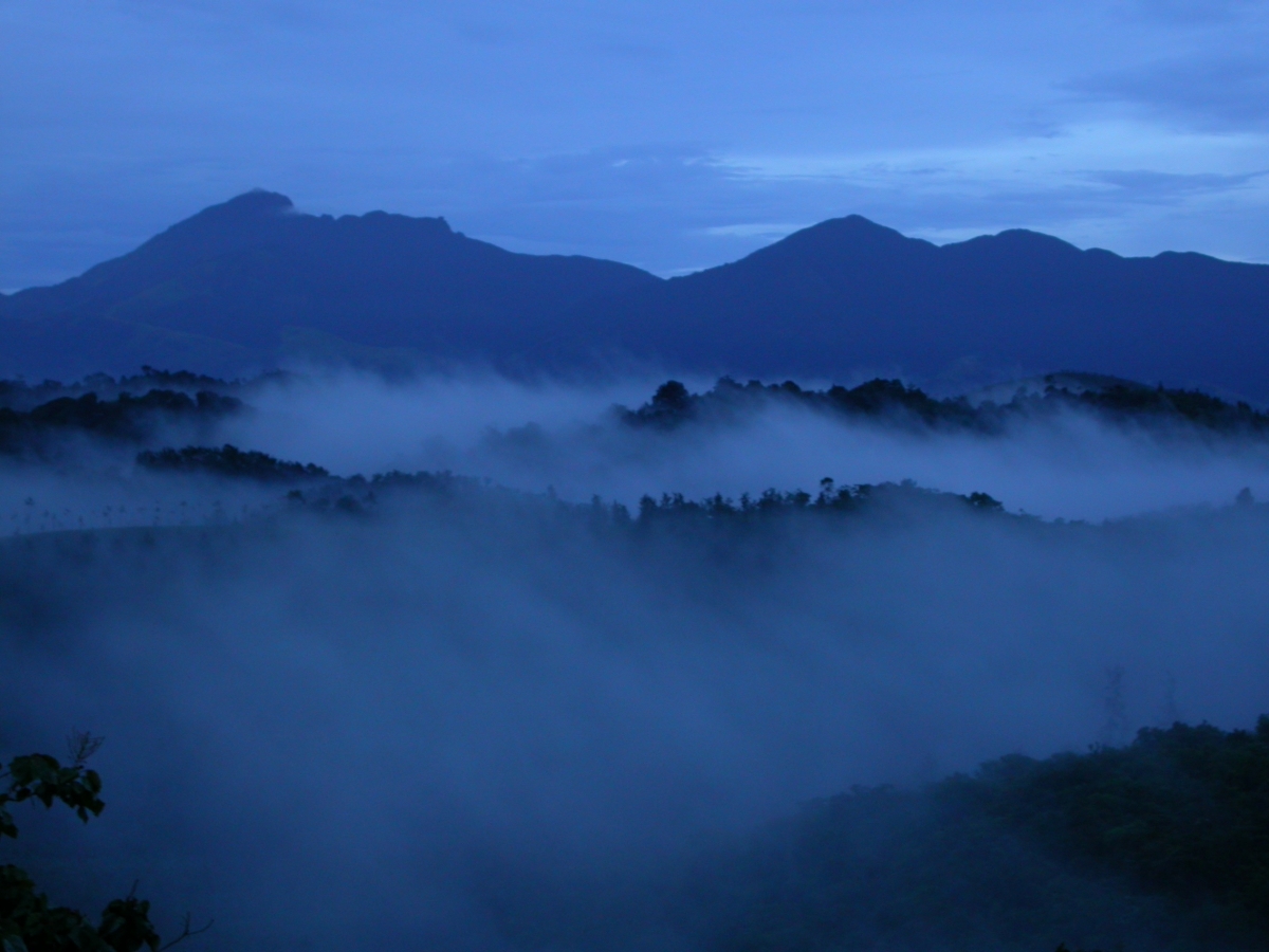
I love being at home, in Wayanad, when the south-west monsoon arrives. This hilly district of northern Kerala is still full of tall trees and myriad creatures, and drenched in rain for several months in a year. From my window, I see Banasuramala, a beautiful mountain 2,000 metres high, gracing the southern horizon, and canopied hills to the west. Small farms make scruffy patchworks on the other sides. To the north-east are the shola grasslands of the Brahmagiris. All around, streams born of millions of seeps gifted by trees gather to flow to the Kabini and then to the Kaveri.
I work at the Gurukula Botanical Sanctuary, where a small team of dedicated ecosystem gardeners, skilled in various aspects of horticulture, plant conservation and Western Ghat ecology, grow native plants of this mountain ecosystem, or biome, through techniques honed over four decades of experimentation and practice. We cultivate plants that are highly endangered in the wild, some 2,000 species in all, accounting for 40% of the Western Ghat flora. We deploy a range of methods, from intensive-care nurseries to outdoor habitats rich with herbs, tubers, succulents, shrubs, trees, creepers, climbers, epiphytes (plants that grow on other plants) and lithophytes (plants that grow on rocks). These species have been initially brought from different parts of the Western Ghats, mostly from areas that have already been deforested. Much of our work is a search-and-rescue mission, and we refer to these plants as refugees, similar to human refugees suffering the depredations of war, displacement, climate change and general toxification of the environment. We also speak of species being rehabilitated when they form mixed-species communities that eventually become quite independent of our care.
Local stream, headwater of Kaveri
Surrounding these “refugee camps” we also have once-denuded patches, adding up to an area of more than 60 acres, which are recovering to forest through natural processes of succession under our vigilance. Since we are on the edge of a reserve forest, still rich and diverse despite its small size of about 100 square km, reforestation happens easily if the land is simply protected—because insects, birds and mammals transfer spores and seeds. Beyond all this, we educate students and visitors about the centrality of the natural world, first of all to itself and then to human lives, including the economy, something most urban people seem to deny, to our collective peril.
Over time, this botanical sanctuary has become a zoological sanctuary. We have noted 220 species of birds, including Malabar trogons, flycatchers, frogmouths and laughing thrushes. Many unusual mammals, reptiles, amphibians and insects abound, and several are endemic to the Western Ghats, such as the iridescent shield-tail snake, the Nilgiri marten, a nimble and ferocious small mammal, and many species of bush frogs.
The sanctuary has become a river-maker too. I’ve seen how moss-laden trees condense mist, how droplets of water gather on downy grasses, how cool it is inside the infant forest we have grown, and how water trickles out of the toes of trees to form tiny rivulets, which flow into neighbours’ fields. By leaving large areas of the land to natural succession, and not deliberately planting trees, as practised by other agencies, and giving time, a slowly restoring area acquires many important properties of a healthy ecosystem. These include species diversity, a thick layer of leaf litter decomposing to humus, a robust water cycle, layered and dense vegetation, and different climates from the canopy all the way down to the shady interior.
Monsoon clouds over Gurukula
As gardeners and habitat-restorers we, of course, are dependent wholly on the timing and duration of the monsoon, on its intensity and quantity—because our wards, namely the land and the plant species we conserve, are. On an average we require 500 cm of rainfall a year, and most of it in the south-west monsoon. The weather features regularly in our speech. Much of our work hinges on the fine sensibilities of land-based peoples: common-sense knowledge to do with life-cycles in the forest and our own intuitive understanding of weather patterns, instead of measurements and forecasts alone.
Changing Monsoon
Most Indians believe that the monsoon is unassailable: a wind system 18 million years old, which has breathed life into the subcontinent since the rise of the Himalayas, whose formidable heights block it from travelling to Central Asia, condensing it instead into long hard rain. Its intensity varies from year to year, but we believe it will blow. But ever since I have been here, about 24 years now, I have heard people talking about how the monsoon has gone awry, that it is no longer what it used to be. We also know this from scientific data, but crucially for us, we know this from the behaviour of the plants and animals in our sanctuary.
Stream in our valley
We depend on both monsoons, together called the double monsoon, but the south-west matters more, as it brings more than 90% of what we need annually. The north-east monsoon, however, makes this a rainforest, along with locally generated thundershowers between the two monsoons, by extending the wet period to cover more than eight months of the year. Typical rainforests have rain or mist throughout the year, as we do here. Luc Lambs, an eco-hydrologist at the University of Toulouse in France, studies the double monsoon system in South India—its variation over time, the role of the forests in water–vapour recycling and what meteorologists call the “gatekeeper” effect of the Western Ghats range. He says the south-west monsoon has weakened considerably over the past three decades, while the north-east monsoon is getting stronger. He also affirms that forests are necessary to condense rain as are the icy heights of mountains.
Impatiens flowers under cultivation
Anecdotal evidence also suggests that the monsoon is changing in fundamental ways. The monsoon was much colder when she was a little girl in this valley, says Laly Joseph, my colleague, recalling how it poured from June to October, with a brief break during Onam, which usually falls in September. For the past decade, however, it has rarely arrived on time, often disappearing after setting in, sometimes drying up in August only to rain very heavily in winter.
The garden is open to the public
Plants Confused
All this fluctuation spells trouble for monsoon-dependent plants. Laly propagates 100 species of endangered native balsams, which belong to the genus Impatiens, all endemic to the Western Ghats, with succulent stems and brightly-coloured flowers, considered by many naturalists to be a flagship group of the range. She says that many species are struggling because they are confused by changing environmental cues: plant hormones are, after all, finely attuned to tiny changes in seasonal patterns of moisture and temperature. For example, species rescued from higher elevations are not doing well at the sanctuary’s 750-metre elevation any more because it is becoming too warm and the rain is often interspersed with long dry spells, which, if too long, can signal the end of the monsoon to these species. Laly is growing these delicate plants in the nursery because their natural habitats have been eroded.The sanctuary’s plant conservation programme envisages that at least a few can be given a toe-hold chance for survival by our tribe of ecosystem gardeners, if lost in the wild, because of rapid alterations to global climate conditions. Also, rising temperatures bring new diseases and many species are succumbing to these.
Upstream from GBS
For the past three years, Impatiens stocksii, a small plant with white flowers that is endemic to Coorg and Wayanad, has been sprouting two weeks later each consecutive year, says Abhishek Jain, our plant scout at large, who travels through the mountains documenting species in the wild. They are thus a month late this year, and haven’t sprouted yet in early June. Both Laly and he say that pre-monsoon convectional showers that lead up to the main monsoon are critical to the dormant tubers setting out their annual leaves and shoots. The pre-monsoon allows for the dormant tubers to start growing underground, and once the main monsoon starts, the plants quickly put out leaf shoots as if assured that a long period of growth lies ahead. The tubers gain in size from the starch made by the photosynthesising leaves. Flowering and seed formation can happen once enough energy is accumulated, usually towards the middle or latter half of the monsoon. Shockingly, this year we had no pre-monsoon rain, and Impatiens stocksii is even more delayed.
I have been keeping a diary to note when trees flower, fruit, produce seeds, drop leaves and flush. There’s a marked difference in these timings between last year and now. Jackfruit, for instance, has fully ripened and fallen in end-May instead of in late June or early July. Mala-elengi (Chionanthusmala-elengii) has flowered and fruited a full six weeks ahead of last year. The southern rudraksh (Elaeocarpus tuberculatus) flowered copiously in early February this year instead of the usual March. I am concerned that some of the trees are masting this year, a term used for synchronised and exceptional production of flowers, fruits and seeds. I’ve heard that this can happen sometimes in anticipation of death by drought. It takes consecutive years of drought to kill mature trees, but when they reach survival’s edge they put their final energy into the next generation by producing copious quantities of seeds.
The Monsoon’s Needs
So we know that the forest needs the monsoon. But we don’t give as much thought to how much the monsoon also needs forests, although most of us have an inkling that plants cool the land and that forests are intimately connected to rain and rivers. Scientists used to refer to rainforests, particularly the Amazon, as the planet’s lungs. Now, some like Luc Lambs and Antonio Nobre, an earth-systems scientist in Brazil, talk about forests acting as biotic pumps, whereby trees release organic molecules into the atmosphere, thereby changing air pressure, which creates a drag effect to draw in the winds from the sea. The proponents of this theory are a pair of Russian nuclear physicists named Anastassia Makarieva and Victor Gorshkov, who studied the contribution of forests all over the world to the global hydrological cycle.
Yet deforestation proceeds untrammelled. A report released in the first week of June by the Indian Institute of Science shows that Kerala has lost half of its forest cover in the past four decades. It is no wonder that the quantity of rainfall has also decreased. If we could reforest more of the land and protect whatever remains of old forest, we could keep droughts and floods at bay, because vegetation has an ameliorating effect on both. Indeed, we keep saying that the monsoon is necessary for agriculture, but we hardly ever talk about what the monsoon needs. In an era when an Indian court redefines the Ganga and Yamuna as “living persons,” let me propose that we look at the monsoon as a being, with its own needs: cooler oceans and lands, glacier-bearing Himalayas, forested Western Ghats, a vegetated India. Further afield, it needs the Siberian permafrost to not melt. It needs the Antarctic to remain icy.
Sights and Sounds
Lately, I have been falling asleep to the songs of different bush-frogs and crickets. Tonight, they outdo every other sound—thunder, passing vehicles and barking dogs. Last week, birds such as nightjars, frogmouths and owls were clearly audible and now they’re drowned out by the insect–amphibian choir.My ears hurt. This raucous medley is a sure sign that the monsoon is here or about to arrive very soon.The trails are full of jackfruit (Artocarpus heterophyllus) and smashed, partly-eaten remains of its relative, the ainili (Artocarpus hirsutus), which sports smaller orange fruits with a spiny skin enclosing lobes of sweet flesh and large seeds. Wild jamuns and mangoes, rose apples, guavas and sweet limes, and dozens of forest tree species are also fruiting. Bonnet macaques, Nilgiri langurs, Malabar grey hornbills and giant squirrels are gorging in the canopy. Someone reported seeing a troop of lion-tailed macaques with babies. It is feasting time for everybody in this valley: wild boar, humans and cattle included. Elephants come by at night, attracted from afar by the smell of overripe jackfruit—to them, a delicacy.
Local forest
Herbaceous plants and creepers are suddenly exuberant with the prospect of regular rain. They grow fast during the onset of the monsoon, infused by nitrogen from lightning and the perfect combination of sunshine and water. Soon, if the monsoon arrives and sustains, the trails and rock-walls will be covered in Impatiens flowers, ground orchids and ferns—a spectacular visual treat.
I fantasise sometimes about a perfect monsoon. Rain that is not too much or too little, neither lasting the whole year nor only a few days, arriving perfectly on the first of June and lasting till October. Rivers full and flowing, everyone happy and well-fed, reservoirs lasting through the summer, and fields and forests growing lush and fecund.
Immersive Programmes
I worry, though, that the monsoon, with its moods and savage powers, might altogether cease. Daily, I awaken to an inescapable prospect in the middle of paradise, this botanical sanctuary in Wayanad. Plant conservation is precious work, and it must be done. But what if the monsoon fails? What will happen if forests and drought get into a positive feedback loop? In other words, what if drought leads to forest fires, leading to less rain, and then to more forest fires and so on? What, then, of rivers and the millions of people downstream?
So I busy myself with thinking about how to conserve the monsoon. I believe it is mostly a matter of stopping toxic or destructive activities. Author Derrick Jensen writes that a single Trident nuclear submarine is capable of destroying 408 cities at once. What sort of a mind could conceive of creating such a machine? It seems to me, it is the same mind that is killing the monsoon. The US army alone can stop the murder of the monsoon. It is the single largest contributor to global warming. Why do I say murder? We know that the military–industrial complex is destroying the planet, and we know that it is happening willfully.
Whom shall we serve? The machines or the monsoon?
Suprabha Seshan (suprabha.seshan@gmail.com) lives and works at the Gurukula Botanical Sanctuary in Wayanad, Kerala. She is the sanctuary’s managing trustee and is an Ashoka Fellow. On behalf of the sanctuary’s ecosystem gardeners, she received United Kingdom’s Whitley Award in 2006.
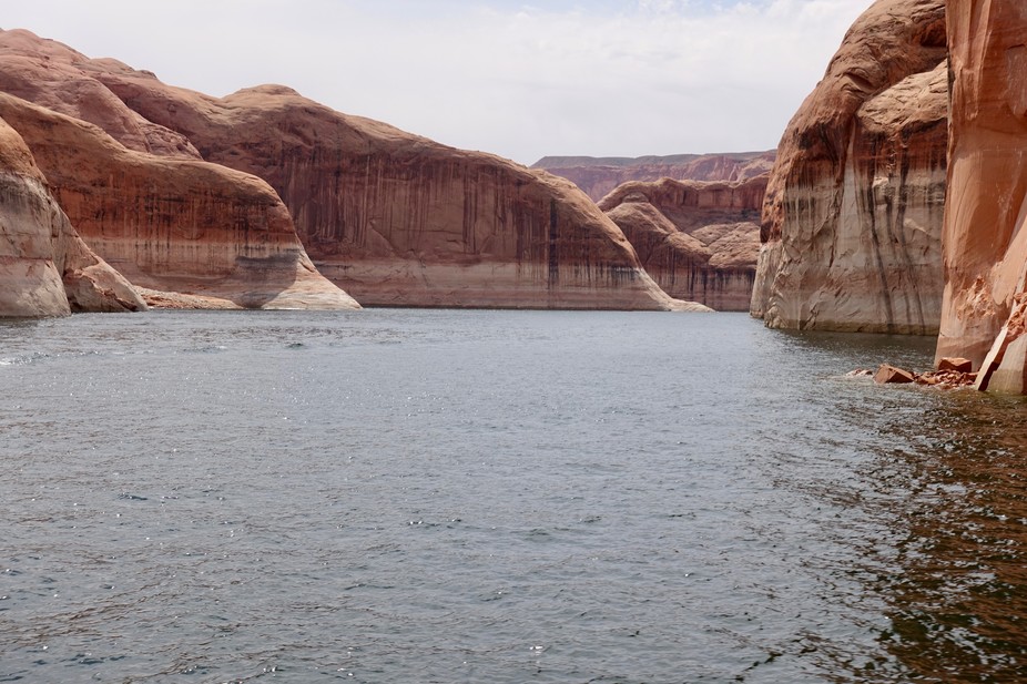
Featured image: Lake Powell, photographed April 12, 2017. The white ‘bathtub ring’ at the cliff base indicates how much higher the lake reached at its peak, nearly 100 feet above the current level. Patti Weeks
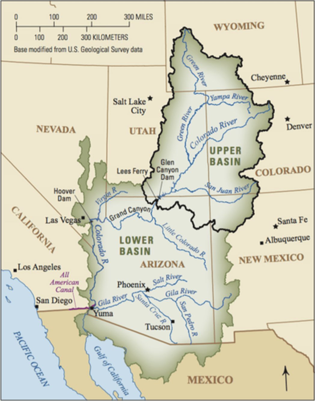
The nation’s two largest reservoirs, Lake Mead on the Arizona/Nevada border and Lake Powell on the Arizona/Utah border, were brim full in the year 2000. Four short years later, they had lost enough water to supply California its legally apportioned share of Colorado River water for more than five years. Now, 17 years later, they still have not recovered.
This ongoing, unprecedented event threatens water supplies to Los Angeles, San Diego, Phoenix, Tucson, Denver, Salt Lake City, Albuquerque and some of the most productive agricultural lands anywhere in the world. It is critical to understand what is causing it so water managers can make realistic water use and conservation plans.
While overuse has played a part, a significant portion of the reservoir decline is due to an ongoing drought, which started in 2000 and has led to substantial reductions in river flows. Most droughts are caused by a lack of precipitation. However, our published research shows that about one-third of the flow decline was likely due to higher temperatures in the Colorado River’s Upper Basin, which result from climate change.
This distinction matters because climate change is causing long-term warming that will continue for centuries. As the current “hot drought” shows, climate change-induced warming has the potential to make all droughts more serious, turning what would have been modest droughts into severe ones, and severe ones into unprecedented ones.
The Colorado River is about 1,400 miles long and flows through seven U.S. states and into Mexico. The Upper Colorado River Basin supplies approximately 90 percent of the water for the entire basin. It originates as rain and snow in the Rocky and Wasatch mountains. USGS
How climate change reduces river flow
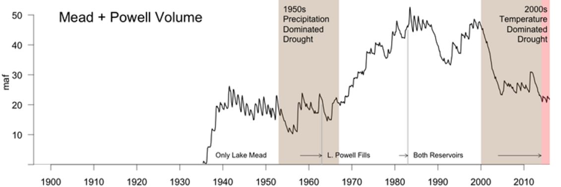
In our study, we found the period from 2000 to 2014 is the worst 15-year drought since 1906, when official flow measurements began. During these years, annual flows in the Colorado River averaged 19 percent below the 20th-century average.
During a similar 15-year drought in the 1950s, annual flows declined by 18 percent. But during that drought, the region was drier: rainfall decreased by about 6 percent, compared to 4.5 percent between 2000 and 2014. Why, then, is the recent drought the most severe on record?
The answer is simple: higher temperatures. From 2000 to 2014, temperatures in the Upper Basin, where most of the runoff that feeds the Colorado River is produced, were 1.6 degrees Fahrenheit higher than the 20th-century average. This is why we call this event a hot drought. High temperatures continued in 2015 and 2016, as did less-than-average flows. Runoff in 2017 is expected to be above average, but this will only modestly improve reservoir volumes.
High temperatures affect river levels in many ways. Coupled with earlier snow melt, they lead to a longer growing season, which means more days of water demand from plants. Higher temperatures also increase daily plant water use and evaporation from water bodies and soils. In sum, as it warms, the atmosphere draws more water, up to 4 percent more per degree Fahrenheit from all available sources, so less water flows into the river. These findings also apply to all semi-arid rivers in the American Southwest, especially the Rio Grande.
The combined contents of the nation’s two largest reservoirs, Lake Mead and Lake Powell, since their initial fillings. The large decline since 2000 is shaded brown for 2000-2014, our 15-year study period, and pink for the continuing drought in 2015-2016. The loss was significantly influenced by record-setting temperatures, unlike a similar 15-year drought in the 1950s which was driven by a lack of precipitation. Bradley Udall, Author provided
A hotter, drier future
Knowing the relationship between warming and river flow, we can project how the Colorado will be affected by future climate change. Temperature projections from climate models are robust scientific findings based on well-tested physics. In the Colorado River Basin, temperatures are projected to warm by 5°F, compared to the 20th-century average, by midcentury in scenarios that assume either modest or high greenhouse gas emissions. By the end of this century, the region would be 9.5°F warmer if global greenhouse gas emissions are not reduced.
Using simple but strong relationships derived from hydrology models, which were buttressed by observations, we and our colleagues calculated how river flows are affected by higher temperatures. We found that Colorado River flows decline by about 4 percent per degree Fahrenheit increase, which is roughly the same amount as the increased atmospheric water vapor holding capacity discussed above. Thus, warming could reduce water flow in the Colorado by 20 percent or more below the 20th-century average by midcentury, and by as much as 40 percent by the end of the century. Emission reductions could ease the magnitude of warming by 2100 from 9.5°F to 6.5°F, which would reduce river flow by approximately 25 percent.
Large precipitation increases could counteract the declines that these all-but-certain future temperature increases will cause. But for that to happen, precipitation would have to increase by an average of 8 percent at midcentury and 15 percent by 2100.
The American Canal carries water from the Colorado River to farms in California’s Imperial Valley. Adam Dubrowa, FEMA/Wikipedia
On a year-in, year-out basis, these large increases would be substantial. The largest decade-long increases in precipitation in the 20th century were 8 percent. When such an increase occurred over 10 years in the Colorado Basin in the 1980s, it caused large-scale flooding that threatened the structural stability of Glen Canyon Dam, due to a spillway failure not unlike the recent collapse at California’s Oroville Dam.
For several reasons, we think these large precipitation increases will not occur. The Colorado River Basin and other areas around the globe at essentially the same latitudes, such as the Mediterranean region and areas of Chile, South Africa and Australia, are especially at risk for drying because they lie immediately poleward of the planet’s major deserts. These deserts are projected to stretch polewards as the climate warms. In the Colorado River basin, dry areas to the south are expected to encroach on some of the basin’s most productive snow and runoff areas.
Moreover, climate models do not agree on whether future precipitation in the Colorado Basin will increase or decrease, let alone by how much. Rain gauge measurements indicate that there has not been any significant long-term change in precipitation in the Upper Basin of the Colorado since 1896, which makes substantial increases in the future even more doubtful.
Megadroughts, which last anywhere from 20 to 50 years or more, provide yet another reason to avoid putting too much faith in precipitation increases. We know from tree-ring studies going back to A.D. 800 that megadroughts have occurred previously in the basin.
March of 2017 was the warmest March in Colorado history, with temperatures a stunning 8.8°F above normal. Snowpack and expected runoff declined substantially in the face of this record warmth. Clearly, climate change in the Colorado River Basin is here, it is serious and it requires multiple responses.
It takes years to implement new water agreements, so states, cities and major water users should start to plan now for significant temperature-induced flow declines. With the Southwest’s ample renewable energy resources and low costs for producing solar power, we can also lead the way in reducing greenhouse gas emissions, inducing other regions to do the same. Failing to act on climate change means accepting the very high risk that the Colorado River Basin will continue to dry up into the future.
A Canadian company, Energy Fuels Inc., is about to begin mining high-grade uranium ore just 5 miles from the South Rim of the Grand Canyon.
If the project goes ahead, the Colorado River could be exposed to dangerous levels of radiation, threatening the water supply for 40 million people downstream, including residents of Los Angeles and Las Vegas.
The Canyon Mine, which pre-dates a 2012 ban on uranium mining near the Canyon’s rim, would annually extract 109,500 tons of ore for use in US nuclear reactors. Post-extraction, 750 tonnes of radioactive ore would be transported daily from the Canyon Mine to the White Mesa Mill uranium processing facility in Utah, traversing Arizona in unmarked flatbed trucks covered only with tarpaulins.
The Canyon mine, located 5 miles from the South Rim of the Grand Canyon. Photo: Garet Bleir
The toxic material would pass through several towns, Navajo communities and the city of Flagstaff en route to the processing facility, which is only three miles from the White Mountain Ute tribal community.
From extraction to transport and processing, every stage of the uranium project could expose this iconic landscape, its watershed and inhabitants to high levels of radiation.
There’s more. With President Trump’s recent cuts to the EPA, and the Koch Brothers’ campaign to remove the uranium mining ban, the entire Grand Canyon region faces an unprecedented threat.
The Havasupai Nation, whose only water source is threatened by the Canyon Mine, has teamed up with several environmental organizations to ask federal judges to intervene before the mine causes any harm.
Meanwhile, members of the Navajo Nation are working to establish a ban on the transport of uranium ore through their reservation and the White Mesa Ute are leading protests against the processing facility.
The Navajo Nation has already been devastated by 523 abandoned uranium mines and 22 wells that have been closed by the EPA due to high levels of radioactive pollution. According to the EPA, “Approximately 30 percent of the Navajo population does not have access to a public drinking water system and may be using unregulated water sources with uranium contamination.” A disproportionate number of the 54,000 Navajo living on the reservation now suffer from organ failure, kidney disease, loss of lung function, and cancer.
The Canyon mine could have a similar impact on the Havasupai Nation and millions of Americans who depend on water from the Colorado River.
IC will be onsite for the next four weeks, investigating the risks and impacts of the Canyon Mine and bringing you exclusive updates from the emerging resistance movement.
We will look at the history of the Energy Fuels processing mill and cover the outcome of the Havasupai lawsuit. We will collect expert testimony, conduct interviews with key players and introduce you to some of the people affected by uranium mining.
We’re launching a crowdfunding campaign later this month to let us complete this vital investigative journalism project.
To build momentum for this fundraising campaign, we need 100 people to join us on Thunderclap and help us send a message that the Grand Canyon has allies!
A windmill blade knocks the head off a Cooper’s hawk interrupting the late afternoon peace in Spring Valley, just outside Ely, Nevada.
The blade tosses the hawk’s body onto yellow gravel the power company spread, over living soil, in circles around their windmills.
The ever-present Great Basin breeze, who usually whispers with a soothing tone through pinyon needles, juniper branches, and sage tops, becomes angry. Grazing cows pause their chewing and look up to consider the scene.
Heads of cheat grass poke through the gravel, only to droop with sorrow for the splayed feathers and twisted wings at their feet. Taller than cheat grass and crowding around the gravel’s edge, crested wheatgrass shakes and shutters with horror in the wind.
The collision’s suddenness and the sickening sound of the blade striking the hawk’s small skull breaks my awareness open with a pop. I seep across the valley floor. I mingle with the wounds on the land and recognize pain in places I previously overlooked. The windmills, the invasive plants, the cows, and the empty scars on the foothills marking pinyon-juniper clearcuts are all evidence of violence.
The gravel at my feet is the remains of stones and boulders that were exploded and crushed, loaded into trucks, and transported to Spring Valley as part of Pattern Energy’s Spring Valley Wind Farm project. Windmill construction means so much involves land clearances, building maintenance roads, and operation of fossil-fuel intensive heavy machinery.
Before the gravel was dumped and the construction project started, the ground I stand on was covered in a complex mosaic of lichens, mosses, microfungi, green algae, and cyanobacteria that biologists call a “biological soil crust.”
Across the Great Basin, biological soil crusts are integral to protecting soil surfaces from erosion. They are also vulnerable to disturbance by construction projects like the one that brought the windmills here. The lichen components of these disturbed crusts can take 245 years to recover. Far worse, soil losses due to erosion following mechanical disturbances can take 5,000 to 10,000 years to naturally reform in arid regions.
The windmills that tower above me fill the air with a buzzing, mechanical sound. Built only four miles from a colony of millions of Mexican free-tailed bats at the Rose Guano Cave, the windmills killed 533 bats in 2013, triple the amount allowed by federal regulations. The majority of these bats are killed by barotrauma. Rapid or excessive air pressure change, produced by windmills, causes internal hemorrhaging. In less abstract language, the bats’ lungs explode.
Both cheatgrass and crested wheatgrass are invasive species. Global shipping routes, which have long been tools of colonialism, brought cheatgrass to North America through contaminated grain seed, straw packing material, and soil used as ballast in ships. Cheatgrass outcompetes native grasses for water and nutrients. It drops seeds in early summer before native grasses and then drys out to become highly flammable.
When wildfires rip through areas cheatgrass has invaded, native grasses are destroyed without seeding. In the fall, after native grasses have burned, cheatgrass seeds germinate and cheatgrass dominance expands. This dominance has been disastrous for the Great Basin. Fire return intervals have gone from between 60-110 years in sagebrush-dominated systems to less than 5 years under cheatgrass dominance.
While cheatgrass was imported by accident, crested wheatgrass was imported from Asia in 1898. By the 1890s, Great Basin rangelands were depleted of water, soil, and economically useful vegetation. Ranchers needed cheap feed for their livestock and crested wheatgrass provided it. It outcompetes native grasses, grows in tight bunches that choke out other species, quickly forms a monoculture, and reduces the variety of plant and wildlife species in places it takes hold. Worst of all, crested wheatgrass supports a destructive ranching industry that should have collapsed decades ago.
Ranching is one of the most ecologically destructive activities in the Great Basin. Livestock grazing depletes water supplies, causes soil erosion, and eliminates the countless trillions of small plants forming the base of the complex food web supporting all life in the region. Ranchers have nearly killed off all the top carnivores on western rangelands and jealously guard their animals against the re-introduction of “unacceptable species” like grizzly bears and wolves.
Ranchers, always searching for new rangeland, encourage government agencies like the Bureau of Land Management (BLM) and the US Forest Service (USFS) to clear-cut forests and remove sagebrush to encourage the growth of graze for their livestock. In the hills north of the wind farm, pinyon pines and junipers lie in mangled piles where they were “chained.”
Chaining is the preferred method for destroying forests here. To chain a forest is to stretch a US Navy battleship anchor chain between two crawler tractors which are then driven parallel to each other while ripping up every living thing in their path.
Ship chain used to clear forests. Photo: Wikimedia Commons
Nevada Highway 893 runs to my left along the west side of the valley. If I followed the road north a few miles, I would run into one of the Southern Nevada Water Authority’s (SNWA) test wells. SNWA installed these wells in the preparation of its Clark, Lincoln, and White Pine Counties Groundwater Development Project that would drain Spring Valley of water and, then, transport the water by pipeline to support Las Vegas’ growing population.
Fortunately, the project has been successfully stalled in court by determined grassroots activists. But, if SNWA eventually prevails, Spring Valley will quickly dry up and little life, endemic or invasive, will survive here.
***
The reminders of violence I encounter in Spring Valley reflect global problems. Windmills are a symptom of the dominant culture’s addiction to energy. The roads here will carry you to highways, highways to interstates, and interstates to airports.
There is virtually nowhere left on Earth that is inaccessible to humans with the privilege, power, and desire to go wherever they will. To gain this accessibility, these humans are so thoroughly poisoning the atmosphere with greenhouse gas emissions global temperatures are rising.
Invasive species – cows, cheat grass, crested wheatgrass, European settlers – are colonizers. They each colonize in their own way. The cows replace elk, pronghorn, wolves, and bears. The grasses eliminate natives by hoarding nutrients and water. They reproduce unsustainably and establish monocultures. When that doesn’t work, they burn the natives out. And, the settlers do the same.
The violence of civilized life becomes too obvious to ignore and the land’s pain threatens to overwhelm me. Despair accompanies these moments. When all I see is violence, it is easy to conclude that violence is all there is, all there ever was, and all there ever will be. Claims I’ve heard repeated countless times echo through my mind.
Humans are selfish. This is just what we do. We will kill ourselves, but the planet will recover…eventually. Humans have been butchering each other for centuries and we’ll butcher each other for centuries more if we don’t destroy the world first.
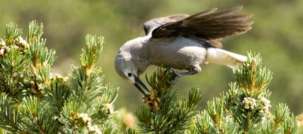
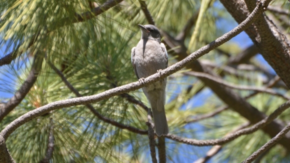
I stand paralyzed under a windmill, with a decapitated hawk at my feet, struggling through my thoughts for who knows how long, when the blue feathers of a pinyon jay catch my eye. At first, it’s the simple beauty of her color that attracts my attention. But, it’s the strangeness of the phenomenon that keeps my attention.
Rows of windmills form the wind farm. I stand under the northernmost row and about one hundred yards separate the rows. The jay lands on a barbed wire fence post about halfway between the row I’m standing under and the first row south of me. Her presence is strange for two reasons. First, pinyon jays prefer to live in pinyon-juniper forests and there are no trees for a mile in either direction. Second, pinyon jays are very intelligent, and she must have known that to brave the circling windmill blades is to brave the same death the Cooper’s hawk just experienced or the barotrauma so many bats experience.
The despair I felt a few moments ago is fading. As I approach the jay I see her picking through a pinyon pine cone. She picks deftly at it before she pulls a pine nut from the brown folds of the cone. It’s not until she lifts her head, with the pine nut in her beak, that I understand.
She flew down from the forests, through dangerous windmill blades, to show me a pine nut.
Pinion Jay – Photo: Wikimedia Commons
***
Pine nuts represent the friendship humans and pinyon-juniper forests have shared for thousands of years. Pinyon charcoal and seed coats have been found in the 6,000-year-old Gatecliff Shelter in central Nevada. Pinyon seed coats have been found with 3,000-year-old artifacts in Hogup Cave in northwestern Utah. Many of the Fremont culture’s ruins (circa 1000 AD) in eastern Utah also show pinyon use.
Pine nuts are symbols of true sustainability. I’ve heard many traditional, indigenous people explain that sustainability requires making decisions with the succeeding seven generations in mind. When the health of the seventh future generation guides your relationship with the land, overpopulation, drawdown, pollution, and most forms of extraction become unthinkable. European settlers arrived to find indigenous peoples in the Great Basin, like so many indigenous peoples around the world, living in cultures that existed for centuries in balance with the land.
And, the pine nut made these cultures possible.
The Washoe, Paiute, and Shoshone all developed cultures centered on pine nuts. Pinyon pine expert, Ronald Lanner notes, “Just as life on the plains was fitted to the habits of the buffalo, life in the Great Basin was fitted to the homely, thin-shelled nut of the singleleaf pinyon.” Pinyons give their nuts freely and harvesting them involves no damage to the trees. In fact, pine nuts are seeds. Animals who collect and gather the seeds – like pinyon jays, rats, mice, and humans – help the trees reproduce.
It’s a beautiful relationship: pinyon pines offer animals food, and animals offer pinyon pines regeneration. At a time when the survival of life on Earth depends upon humans embracing their role as animals, the relationship the Washoe, Paiute, and Shoshone built with pinyon pines serves as a model for the world.
Relying on the research of American Museum of Natural History archaeologist David Hurst Thomas, Lanner describes the central role the annual pinyon festival played in Western Shoshone life. He writes, “…when pinyon harvest time arrived, Shoshone bands would come together at a prearranged site. There they would harvest nuts, conduct communal rabbit drives, and hold an annual festival. The pinyon festival was the social highlight of the year and was often attended by several hundred people. At night…there was dancing…There was gambling among men and courting among the young. Marriages were arranged and sexual liaisons conducted.”
Pine nut crops, like all natural processes, are subject to variation. There are good yields and bad yields. Human cultures dependent on the land are constantly confronted with a choice. Either humans can tighten their belts and reduce their populations voluntarily. Or, they can exploit the land, stealing resources from the future to meet the needs of the present.
Lanner describes how Western Shoshone sustainability was maintained, “…the pinyon festival was used as an opportunity for regulating the future size and distribution of Shoshone populations. If at the festival the intelligence from all areas foretold a failure of next year’s crop, then measures could be taken to avoid mass starvation…Births could be limited by sexual abstinence or abortion. One or more twins could be killed at birth, as could illegitimate children…The sick and the old could be abandoned. A widow might be killed and buried beside her husband.”
Some of these measures may seem harsh to us today. But, when we consider the violence necessary to sustain today’s civilized, human populations, we will realize that some of these difficult decisions are what true sustainability looks like. Killing a twin or abandoning the sick is small violence compared to the mass violence of deforestation, anthropogenic desertification, and climate change.
***
The pinyon jay in Spring Valley shows me both a pine nut and the history of human sustainability. Even though Spring Valley, with the rest of the world, currently reflects too much human violence, the vast majority of human history reflects true sustainability. Modern humans have existed for 200,000 years. For the vast majority of that time, most of us lived in cultures similar to the Western Shoshone. We must not forget where we come from.
Meanwhile, ecological collapse intensifies. Violence against the natural world is so pervasive it must be considered a war. Perceiving this war hurts. The pain offers us two choices: endurance or cure. Either the pain is inevitable, an unavoidable fact of life that must be endured. Or, the cause of the pain can be treated and healed.
The pervasiveness of violence tempts us to conclude that it is inevitable. When everywhere we look, we are met with human destruction, it is easy to believe that humans are inherently destructive. This is one reason why the dominant culture destroys the natural world so zealously. If violence is inevitable, there is no reason to stop it.
This is also why the dominant culture works to destroy those non-humans we’ve formed ancient friendships with. If the dominant culture eradicates bison, it destroys our memory of how to live sustainably on the Great Plains. If the dominant culture eradicates salmon, it destroys our memory of how to live sustainably in the Pacific Northwest. If the dominant culture eradicates pinyon-juniper forests, it destroys our memory of how to live sustainably in the Great Basin.
There is a war being waged on the natural world and wars are fought with weapons. The pinyon jay brings me a weapon against the despair I feel recognizing pervasive violence in Spring Valley. She shows me that the violence is not inevitable. She shows me the path to true sustainability, and in doing so, shows me the path to peace.
To learn more about the effort to protect pinyon-juniper forests, go to Pinyon Juniper Alliance. You can contact the Alliance here.
Join us for a flash rally outside of the Annual General Meeting of Copper One – a mining company that has been relentlessly pursuing a claim on Barriere Lake’s land despite firm and repeated refusals by the community.
Community members will be driving to Toronto from Barriere Lake to attend the meeting and tell them there is no possible way they will ever get community consent to drill on Barriere Lake’s unceded Algonquin territory. Just like they’ve been doing since 2011.
The company’s claim covers a large area of the La Vérendrye wildlife reserve and a neighbouring area including the headwaters of the Ottawa River.
In spite of a government decision to suspend the company’s mining claims earlier in 2017, Copper One has repeatedly stated its intention to begin exploratory drilling on the territory of the Algonquins of Barriere Lake.
The Algonquins of Barriere Lake have consistently refused mining exploration on the territory claimed by Copper One. This traditional and current-use territory of the community has been subject to agreements between the community and the governments of Quebec and Canada concerning the joint management of renewable resources, namely the Trilateral Agreement of 1991 and the Bilateral aggreement of 1998. The community has accepted some forms of development on this territory, but has repeatedly stated that mining is not acceptable.
The community objects to the Quebec’s Mining Act’s failure to require consultation with indigenous nations. The Mining Act also fails to allow integrated land use planning in respect of indigenous peoples’ rights and aspirations, including the possibility of saying “no” to mining claims located in culturally or ecologically sensitive areas.