Editor’s Note: Brave activist throughout the world risk their lives to protect the environment. We honor and respect their courage and realize that they are truly heroes. May they remain safe and in our thoughts to give them strength to carry on. Are you working with an organization that protects the environment?
Over nearly 30 years, Carlos Zorrilla and the organizations he co-founded helped stop six companies from developing open-pit copper mining operations in the Intag Valley in Ecuador. As a leader and public figure, Zorrilla is often for advice from communities facing similar struggles, so in 2009 he published a guide on how to protect one’s community from mining and other extractive operations. The 60-page guide shares wisdom and resources, including mines’ environmental and health risks, key early warning signs a company is moving in, and advice on mitigating damage if a mine does go ahead. The most important point, Zorrilla says in an interview with Mongabay, is to stop mining before it starts. Carlos Zorrilla is a leader in what locals say is the longest continuous resistance movement against mining in Latin America.
Zorrilla’s family fled from Cuba to the U.S. in 1962 when he was 11 years old. He moved to the Intag Valley in Ecuador in the 1970s, citing his love for the cloud forest ecosystem there. Soon after he arrived, so did the first of the mining companies.
Over the following decades, Zorrilla and the organizations he co-founded, including DECOIN (Defensa y Conservación Ecológica de Intag), helped block five transnational mining companies and a national company from developing operations in one of the planet’s most biodiverse ecosystems.
In the process, Zorrilla and community members say they faced personal threats, smear campaigns, arrests and violence. But the movement also notched historic wins, including a constitutional case upholding the rights of nature against Chilean state-owned miner Codelco and the Ecuadorian national mining company in 2023.
Community members holding a sign that says, “let’s save Intag.” Communities in Intag Valley have been resisting mining for nearly 30 years. Photo by Carlos Zorrilla.
As a leader and public figure, Zorrilla is often sought out for advice by people facing similar threats. In response, he and two co-authors published Protecting Your Community From Mining and Other Extractive Operations: A Guide for Resistance in 2009 and an updated version in 2016. (The guide is also available in Spanish, French and Bahasa Indonesian).
“After getting rid of two mining companies, I was constantly being asked how the hell we did it,” Zorrilla tells Mongabay. “Rather than keep answering individuals, I wrote the manual. It’s much easier to just say, ‘Read the manual!’”
The 60-page guide shares experiences and resources, including the environmental and health risks of mines, strategies to prevent mining before it starts, key early warning signs a company is moving in, and advice on mitigating damage if a mine goes ahead.
Zorrilla says the most important point is to stop mining before it starts. To emphasize this point, he also published Elements for Protecting Your Community from Mining and Other Extractive Industries, which focuses on preventing mining from gaining a foothold.
.
“Stop the companies before they corrupt your communities and before they discover economically viable mineral deposits,” he says. “Once they start investing in exploratory activities it becomes progressively harder to get rid of them.”
Mining is a divisive issue within Indigenous and local communities. Some see economic benefits to address poverty, own their own mining projects, and highlight the need to negotiate better benefit-sharing agreements or collaborations with mining projects as a form of self-determination.
“But these memorandums only work with ethical mining companies and they are as rare as chicken teeth,” Zorrilla says.
Zorrilla’s opinions on mining are contentious. After the publication of the resistance guide, Ecuador’s president at the time, Rafael Correa, denounced it on public television as “destabilizing” and a foreign-led interference, in a move that Zorrilla says was “great publicity for the manual.”
Former Ecuadorian President, Rafael Correa, holds up Zorrilla’s resistance guide on public television in 2009, denouncing it as “destabilizing”.
As the world transitions away from fossil fuels, the demand for critical minerals to feed “clean” energy technologies such as electric cars is rising. Thus, mining is also increasing.
However, many experts say mining in Ecuador, especially in the Intag Valley, is just a bad idea. Aside from the earthquakes, rainfall, steep slopes and lack of infrastructure, it’s a country with a wealth of other options for development, such as ecotourism potential or sustainable agriculture.
“It’s really a poor choice to develop large-scale mining in such a rich country,” says William Sacher, professor and researcher at Simón Bolívar Andean University in Quito, who studies large-scale mining and its impacts. “If you actually do the math just in terms of cost and benefit, if you take into account the costs of large-scale mining, they outweigh the benefits.”
Zorrilla’s work with DECOIN resisting mining as well as restoring forests and watersheds has been internationally recognized with awards, including the United Nations Development Programme’s Equator Prize in 2017. This year, Zorrilla won the Global Alliance for the Rights of Nature’s award for defending nature’s rights.
It’s his connection to nature, he says, that keeps him motivated. “It is hard to put into words the connection I feel with the land and people, with the biological community I am part of,” he says. “What else could someone do that feels to be an integral part of a community? How could one not defend it against forces that would destroy it?”
In an interview with Mongabay’s Liz Kimbrough, Zorrilla discusses the guide and his experiences.
An open pit copper mine in DRC. Image by Fairphone (CC BY S.A. 2.0)
Mongabay: What inspired you to write this guide?
Carlos Zorrilla: I think two main reasons motivated me to write the guide. The first and most important was that we had gone through a lot in confronting a Japanese and a Canadian mining company in the 1990s and the early 2000s and had to do so without any idea of how to go about it. I kept wishing there was some concrete information on the best ways for communities to confront the presence of these companies. Much as I looked around, I was unable to find anything.
I thought other communities could benefit from our experience in successfully standing up to two transnational mining corporations and blocking mining development in our area (as of early 2024, civil society in Intag has been able to block five transnational mining companies and a national one from opening a mine).
The second reason is much more practical. After getting rid of two mining companies, I was constantly being asked how the hell we did it. Rather than keep answering individuals, I wrote the manual. It’s much easier to just say, “Read the manual!”
Mongabay: You mention that preventing a project in the exploration phase is much easier than stopping it once mining has started. What are some early warning signs that communities should look out for?
Carlos Zorrilla: First, it helps to clarify why it’s so much more difficult to stop a mine once it has opened. A large mining company can incur hundreds of millions of dollars in exploration costs — costs that, in most cases, the country issuing the licenses could be held liable for if the mining company is unable to develop the mining site. This is a result of a country signing bilateral investment treaties with other countries to protect the investments of private companies.
So, in essence, the more a company invests in a project, the more expensive it is for a signatory country to pay off the mining company to go home.
The other reason is that the longer a mining company is a territory, the more likely they are to learn how to co-opt people and institutions, and they waste no time doing so. It’s similar to contracting cancer or other similar diseases: you’ve got to treat its soon as possible, otherwise it becomes deadly or ravages your body so badly that it becomes unable to defend itself.
Another reason it is imperative to stop a company in its initial stage or before is that the longer a mining company explores, the greater the possibility of finding an economically viable ore deposit. If they are successful, companies are much more likely to convince governments to allow all permits and look the other way in cases of illegal activities. It is also much easier for the company to find investors if they can show they have a viable mine to develop.
Mongabay: What are the first signs a company is interested in exploring territory?
Carlos Zorrilla: You may find strange people wandering around the community asking questions. Another is if you suddenly find that private individuals start to buy large tracts of land. Your community could be subjected to social and economic surveys carried out by a government agency under the guise of social or economic development or identifying health needs.
Keep in mind that it’s essential for the companies to find out as much as they can about the communities and the inhabitants they will be dealing with. This also goes for local government needs. For example, they may identify basic needs, such as the lack of basic health services, road and school infrastructure that needs repairing, lack of safe drinking water, etc. Once these needs are mapped out, they will offer the community and/or subnational governments financial help to address them. They often even offer to create so-called development groups or organizations, such as farming co-ops or women’s groups, and provide initial funding to address some of the needs. Companies may sign financial agreements with local or state governments to help cover the costs of supplying communities with basic necessities.
Needless to say, the funding always has strings attached to it, the least of which is that the subnational governments and community groups support the mining company’s presence and, later, the development of the mine.
The most important thing to remember is that the main objective of the companies is to create complete dependency on what they provide, whether it is jobs, road maintenance, drinking water, or basic health services. The inhabitants become so accustomed to having the services provided by the companies that they forget that they have lived without these things all their lives or that it is the state or national government’s responsibility to provide them. The dependency can become so instituted that the locals stop petitioning the local or national governments to provide the services and rely solely on the companies. This can also apply to subnational governments, especially when the national governments purposely reduce their funding as a strategy for the mining projects to gain support from the local populace.
At the same time, the companies are gathering basic information about the community, they are also identifying key players within the community. These are persons who have influence or could be groomed to hold a position of authority. They are the first ones co-opted. It could be someone successful in business or a well-respected community leader. They, in turn, will do a lot of the work for the company, such as convincing their neighbors that mining is the best way for the community and families to get out of poverty. Or it’s really silly not to accept the company’s support to build that road everyone always wanted. That propaganda is infinitely more effective when espoused by individuals you know and respect.
Community members in Intag protest mining in the forest. Image courtesy of Carlos Zorrilla.
Mongabay: What do you believe are some of the best ways to stop a mine before it starts?
Carlos Zorrilla: The best way to know what you’re up against is to find out all that you can about the company: things like who the owners are, the company’s history, main sources of funding, and where the company’s stocks are traded (if it is a publicly traded company).
Once you know all that you can about the company, your main objective is to stop it before it starts gathering information, hiring community members, or buying land — certainly before it holds meetings in your community.
As soon as you suspect a company is interested in your territory, hold public meetings or assemblies where, hopefully, most of the community’s adult population can participate in deciding whether to meet with the company. It can help to invite knowledgeable people to discuss some of the problems the community will have to face if they open the door to mining.
It is absolutely essential that no one accepts meetings with company officials or government employees promoting mining development unless it’s in a public setting with everyone from the community invited.
It is strongly recommended that the bylaws of the community include provisions for any approval of activities affecting the natural environment or social peace of the community be approved by two-thirds majority of the community members. It is dangerous to let the board members of the community (president, vice president, secretary, etc.) represent the community when it comes to allowing activities that could have such terrible and long-lasting social and environmental impacts.
Mongabay: The guide says mining companies use many tactics to divide communities and quell opposition. What’s the most difficult company tactic to counter that you’ve encountered? What should communities be aware of?
Carlos Zorrilla: The companies can use multiple tactics to neutralize the opposition. We’ve experienced just about all. Anywhere from making up criminal lawsuits to try to imprison effective opposition leaders and hiring paramilitaries to violently access the mining site, to death threats, outright buying community leaders, to terrible smear campaigns aimed at discrediting resistance leaders and/or the organizations that support the communities.
Then there are soft tactics. One of the hardest to counter is the easy money that the companies offer to the leaders and, eventually, community members when they start working for the company. This is especially effective in areas where making a living off the land is difficult.
Needless to say, this will lure people away from the fields and the normally hard work that is agriculture. Remember, the company offers steady paychecks, often accompanied by social security and health coverage. One of the things we must do is point out that these jobs will not last more than a few years or until the mine opens. Only qualified personnel are required once a mine opens, with few exceptions. But the company will never admit to it.
Communities have to know what the sacrifices are of accepting the jobs the companies offer. These include very often permanent, ongoing social conflicts; it could also lead to the relocation of whole communities to make room for the mine and its infrastructure, possibly contamination of water sources, desecrating sacred lands, and direct impacts on sustainable activities like ecotourism or agroecological farming.
It’s also been documented that there is more delinquency and violence surrounding mining projects, among many other negative impacts. The impacts are especially hard on women. Most mining jobs go to men, worsening economic inequality within households. Women often have to replace men’s work in the fields, adding even more stress to their daily lives. There also tends to be more health problems from STDs, plus more interfamily violence in mining sites.
So, when mining companies come offering jobs, communities have to consider all the impacts, not just look at the positive aspects.
That is why it is so important not to let the company get this far. Communities have to know that mining companies and government officials lie when it comes to convincing communities about mining. That is one of the most important messages. They have to lie because if they were to tell the truth about the social and environmental impacts of mining, not a single person in the community would support them.
In this light, it’s important to invite knowledgeable persons and community members from other communities that have suffered at the hands of mining companies to share with the communities what really goes on when mining companies roll into your community.
Liz Kimbrough is a staff writer for Mongabay and holds a Ph.D. in ecology and evolutionary biology from Tulane University, where she studied the microbiomes of trees. View more of her reporting here.
Editor’s note: Exxon Mobil recently discovered more oil and gas fields in the disputed territory of Esequibo in South America. Guyana has already awarded drilling bids to the corporation. But Venezuela claims the region its own. News about the developments changes rapidly: On December 3rd the Venezuelan people voted 96% in favor of the non-binding referendum María Páez Victor writes about. Nobody informed Indigenous leaders in Esequibo about the situation, according to Deutsche Welle.
The question one might ask now is: will Guyana and Venezuela be able to protect Esequibo’s dense rain forest together with its indigenous peoples, or will Exxon Mobile set up yet another “carbon bomb”?
Apart from oil and gas, Exxon Mobil wants a part of the electric vehicle cake, too: As global energy demand grows, the corporation will start producing EV-batteries in 2026 in Arkansas.
Attacks on Venezuela by the USA and its allies include 930 illegal sanctions that shut the country out from international finance blocking it from buying medicines, food or producing or selling its oil.
Also there have been direct and indirect support for coup d’etat attempts, street violence leading to murders and injuries, cyberattacks on its electricity grid, sabotage of oil and infrastructure, financing criminal bands, corruption of officials, assassination attempt against the President and his cabinet, setting up a false presidency, appropriating CITGO oil company and billions of Venezuelan assets in banks, blocking the country from obtaining Covid-19 vaccines during a pandemic, and a brutal attack on the currency. It is estimated that at least 100,000 Venezuelans have lost their lives due to the illegal sanctions.
It seems it has not been enough.
Now, wrapping itself in old-fashioned colonialism, the USA through its creature Exxon Mobil, and hand in hand with its imperial ally Great Britain, are poised to pull the biggest land grab since the US took a quarter of México, by means of sleight-of-hand judicial theft.
Long standing issues – land and gold
All the ancient maps of Venezuela, from the time it was first mapped under Spanish rule, show that its eastern border was the Esequibo River.
On the other side of the river was a territory later claimed by England that became British Guiana. It was a place where explorers thirsty for gold invaded seeking the myth of El Dorado, which they did not find but did find gold and the sweet gold of sugar cane. Using a deliberate misinformation campaign, involving the bogus cartography by R. Schomburgk, as far back as 1835, the British Empire made inroads into Venezuelan territory.
After Britain gave independence to British Guiana and it became Guyana, these inroads did not cease. The territory to the west of the river called Guayana Esequiba, thus claimed by Guyana and which is in dispute, measures 159.542 Km², a territory bigger than Portugal and the Netherlands together.
The long-standing controversy reached a point when in 1899, an Arbitral Tribunal in Paris was convened to settle the matter – with not a single Venezuelan present! The judges were from Britain, the United States and one Russian. The USA, claiming some sort of reason to be there because of their own Monroe Doctrine, presumed to represent Venezuela. The sentence, to no one’s surprise, benefited Great Britain.
Venezuela continued to fight this astonishing judicial theft of the land that had always been part of Venezuela, and after long diplomatic struggles, the Accord of Geneva of 1966 was agreed upon by both parts. It emphatically declared null and void the actions of the Paris Tribunal of 1899, and stipulated that both parts – Venezuela and Guyana- are obligated to negotiate amicably together in good faith to resolve all matters concerning the Esequibo. Furthermore, considering this Accord, in 1980 both parties agreed to the United Nations mechanism of Good Offices, whereby a jointly appointed person would help implement negotiations.
Exxon Mobil and today’s issue – black gold
In 2014/15, the most sinister and predatory oil corporation in the world, Exxon Mobil -an avowed enemy of Venezuela- discovered oil in land and sea of the disputed territory. That ended all the ongoing amicable negotiations between Venezuela and Guyana, as the wealth of Exxon Mobil obtained the upper hand of the government of Guyana.
The present prime minister, for example, has been handed $18 million in exchange for refusing to negotiate further, denouncing the Geneva Accord of 1966 and demanding that the decision of the 1899 Paris Tribunal be enforced through yet another biased team of judges at the International Court of Justice, that actually has no jurisdiction except its own self-enlarged mandate.
But most dangerous of all, the oil corporation urges Guyana to aggressively provoke Venezuela into attacking so that it can present itself to the world as a “victim” of Venezuela. The aim is to provoke a frontier war so that the naval fleet of the US Southern Command – now conveniently posted in the adjacent seas- can then intervene militarily and invade Venezuela. Since 2015 Guyana has been carrying out military manoeuvres with the Southern Command with Venezuela as a target.
There is nothing the USA would want more than “a cause”, real or not, to invade Venezuela and get its hands on the rich oil, gas and precious minerals that are abundant there. It can no longer count on stooge right-wing governments in Colombia and Brazil, so now it is manipulating Guyana to be its surrogate war monger. The fleet of the US Southern Command is already poised in waters off the Esequibo and, in fact, the USA has army presence in Guyana itself.
However, Venezuela clearly understands this ruse. It has repeatedly stated that Venezuela has never gone to war – except when its armies marched to Colombia, Peru, Bolivia, and Ecuador to liberate them from the Spanish Empire. Venezuela seeks a peaceful outcome.
The people of the Esequibo
Guyana is one of the most unequal and poor countries in the region.
Its resource extraction enterprises are in the hands of foreign corporations, and the income they grant the country has not had the corresponding impact on the health and welfare indicators of the population. The first attempt to measure poverty was in 1992-93, later repeated in 2006. An academic scholar has concluded:
“The economic history of Guyana is one of slavery, indenture, colonialism and a social stratification based on skin colour.”
The first free elections occurred just as recently as June 1953, but were followed in October of the same year by a British invasion with troops and ships, abetted by the USA, which overthrew the elected populist government of Cheddi Jagan y Forbes Burnham.
Its society suffers with accusations of corruption, inefficiency, and police brutality It has about 78,500 indigenous peoples, 10% of the population, that have been sadly, and historically neglected by the Guyanese government but are now defending their rights through their own movements as since 1990 multinational resource exploitation has increased and highlighted the failure of the government to recognize and guarantee indigenous rights.
Many indigenous people of the Esequibo consider themselves Venezuelans, or at least of dual nationality. Since the Chávez government, Venezuela has been proposing joint ventures that would benefit both countries, especially the population in the Esequibo, just as it has effective and amicable gas exploitation with Trinidad and Tobago on shared seas.
The referendum
Venezuela’s position on the Esequibo is based on the borders it has always had since it was a General Captaincy of the Spanish Empire as clearly stated in Article 10 of the Venezuelan Constitution. It also emphatically declares that the nation’s sovereignty resides in the people, and that the Republic is democratic, participatory and protagonist, multiethnic and pluricultural.
In Article 70, referenda are indicated as one of the ways in which the people can participate in the exercise of their sovereignty. Furthermore, Article 71 states that matters of special national transcendence can be submitted to a consultative referendum.
Therefore, on 6 December 2023 the Venezuelan people will be asked to answer “yes” or “no” to 5 questions: if they reject the 1899 Paris arbitration, approve of the 1966 Geneva Accord agreement as the only binding mechanism to resolve the issue, agree with not recognizing the International Court of Justice’s jurisdiction, oppose Guyana’s unilateral appropriation of the Esequibo’s territorial waters. The 5th key question asks voters if they agree with establishing a new state, called Guayana Esequiba, in the disputed land, granting Venezuelan citizenship to its inhabitants and implementing accelerated social programs.
This last question is of critical political relevance because it, in effect, offers the Esequibo people all the advantages, rights, equality, services and prosperity that today the Venezuelan government and institutions can provide to its citizens. It is so crucial that immediately Guyana and Exxon Mobil demanded of the International Court of Justice be brought into the dispute to do something impossible: to forbid the nation of Venezuela to carry out a referendum for its own citizens! That is, to directly intervene in the domestic affairs of a sovereign country and violate its Constitution. Thus is the fear that they have towards the voice of the people.
However, the ICJ does not actually have jurisdiction over this issue not only because for years it has creepingly and unilaterally expanded its own mandate, but also because any demands of this nature must be made by both parties, and Venezuela has not accepted that court’s involvement or jurisdiction.
Yet Exxon Mobil has paid for Guyana’s substantial legal fees before this court.
Oil corporation “paying” to grab land
Venezuela’s electoral process -considered by former US President Jimmy Carter as the best in the world- always carries out a trial vote just to make sure everything is in working order. This trial vote on November 19th had a surprising result: the turnout was three times larger than in any other election trial, more than 3 million voters turned up! This is a clear indication of the great interest that Venezuelans have in the Esequibo. In fact, the Esequibo is the most important unifying issue in Venezuela today. Government, artists, oppositions, NGOs, unions, private sector, educators, etc; it seems the entire country is standing up in defense of the Esequibo.
But there is one factor, apart from maps, judicial lawfare and referendum, that will impact on this issue: it is Exxon Mobil and the millions it is distributing among politicians, lawyers, and media to get this land grab.
Exxon Mobil is perhaps the most criminal oil company in the world.
For decades its engineers knew well what fossil fuels were doing to the climate, but not only did they supress this information, they paid writers, scientists, and media to deny climate change was happening. It has violated human rights of countless rural and indigenous people; and in Indonesia its collaboration with a brutal government led to it being accused of genocide.
Its seems wherever it operates it commits ecocide, crimes against nature.
One of its worst crimes was the environmental disaster caused by its oil tanker the Exxon Valdez. In 1989 it spilled 10.8 million gallons of crude oil in Alaska, causing the death of between 100,000 and 250,000 marine birds, hundreds of otters, seals, eagles, orcas and innumerable fish.
Exxon Mobil spent years fighting in courts, denying its culpability, and trying to squirm out of paying for damages caused. In the end, after 20 years of litigations, it paid the state of Alaska the pittance of $507 million, that is one tenth of the cost of the damages caused by its oil spill.
If it can do this to Alaska in its own home country, imagine what little environmental protection the people, and pristine flora and fauna of the Esequibo would get from this irresponsible corporation.
This is the monster that has bought Guyana and that is attacking the sovereignty of Venezuela.
What is at stake
This is not merely a territorial dispute between two countries, but more than that, what is at stake is the validity of international law, the integrity of the Geneva Accord of 1966, the integrity of the Good Offices of the United Nations, and the honesty of the International Court of Justice (if it has any).
In the end it is the struggle between democracy and the rapacious interests of a powerful oil corporation in the service of the United States empire.
However, Venezuela has defeated an empire before.
María Páez Victor, Ph.D. is a Venezuelan born sociologist living in Canada.
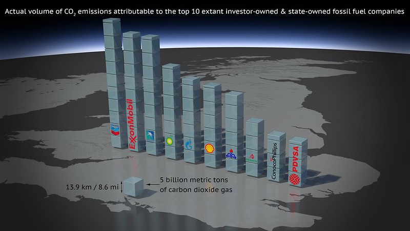
Graph: Top 10 Carbon Majors (with caption & annotations) by Carbon Visuals is licensed under CC BY 2.0.
Editor’s Note; It is important to understand the difference between a reform and a revolution in any political movement. A reform aims to tweak some aspects of the system to make it more equitable, fair and just. A revolution, on the other hand, changes the overall structure of the system. DGR, as a radical environmental and a radical feminist organization, believes that reforms are not enough in a system that is inherently rooted in oppression and injustice. We believe that a revolution is necessary to remove that deep rooted structural violence. However, we also understand that a revolution requires political organizing at a much larger scale. While we are working on building that political movement, the natural world is being destroyed. Till then, something needs to be done to protect the pieces of natural world that we have left, no matter how small. That is where reforms contribute. We understand the perseverance and diligence it takes to bring about any reform and appreciate those who are working on it. Below is the story of such a movement. Though originally designed to be much more protective of nature and indigenous people, the mining laws in Mexico were modified to be much less than that by the time they were passed. The US is still ruled by the Mining Law of 1872.
Reforms to Mexico’s mining law limit harmful practices by extractive industries and improve protections for the environment and Indigenous peoples. But they’re also a far cry from the change activists had been hoping for.
Under the new reform, Indigenous communities will receive 5% of a mining operation’s profits. The maximum lifespan of mining concessions is also reduced from 100 years to 80.
Concessions will no longer be granted in areas with water shortages or in protected areas. Currently, there are 1,671 mining concessions in 70 protected areas in Mexico, spreading across 1.5 million hectares (3.7 million acres) of preserved land.
MEXICO CITY — A major reform approved by congress last week is supposed to limit harmful practices by the mining industry and improve protections for the environment and Indigenous peoples. But some parts of the reform faced strong resistance from pro-business interests, resulting in a watered-down version that some environmentalists said doesn’t go far enough.
The reform, originally introduced by President Andrés Manuel López Obrador at the end of March, was designed to make it harder for private companies to obtain mining concessions without accounting for impacts on surrounding ecosystems and local communities.
It establishes free and prior consent as a requirement for mining concessions, meaning that companies must meet with residents to discuss the impacts of their projects before receiving permits. It also requires companies to restore the land once a mine closes.
But some of the most impactful components of the proposal were negotiated down. Payment to Indigenous communities living near mining operations was originally supposed to be 10% of mining profits but lawmakers reduced it to 5%.
There was also debate about the length of mining concessions, which the previous version of the law set at up to 100 years. Although the original reform proposal wanted to limit it to just 30 years, effectively preventing the companies from shaping entire regions for the long term, lawmakers ultimately settled on 80 years.
“These topics were suppressed or modified without justification and under pressure from the business interests that are responsible for social and environmental devastation,” Colectiva Cambiémosla Ya and Alliance for Free Determination and Autonomy, two mining activist groups, said in a statement ahead of the senate vote.
Deputy Ignacio Mier Velazco, from the state of Puebla — who explained that the reforms were changed to avoid risking investment and economic development — said he was confident the version that was passed would still improve oversight of the industry. Many activists in the region agreed, telling Mongabay the reforms were a victory that allowed for some positive change and a way forward for the continued fight against mining.
Mexico’s mining industry has experienced rapid growth since 1992, when the original mining law was passed. The country has become a top exporter of silver, zinc and other important minerals. In the 1980s, less than 1% of Mexican territory was under a mining concession. Now, it’s a little more than 8%, according to the president’s reform proposal.
The private sector made a push to stall the vote when the initiative was introduced last month, accusing the president’s party, Morena, of fast-tracking the process before the end of legislative sessions in April. The Confederation of Industrial Chambers of Mexico (Concamin) and Association of Mining Engineers, Metallurgists and Geologists of Mexico (AIMMGM) called for additional dialogue with lawmakers. Credit rating agency Moody’s argued that limitations on the length of concessions could hinder growth in the sector. Officials in Canada expressed concern about whether the reforms would impact investments and Mexico’s commitment to international trade agreements. A senate commission that needed to approve the proposal even declared a recess in order to delay voting just days before the end of the legislative session. But the proposal was eventually approved on the final day with a vote of 66 in favor and zero against because the opposition wasn’t present to vote.
Other major changes
Under the original mining law, companies could easily buy up land because extractives activities were listed as having a higher economic benefit than sectors like agriculture and tourism. Now, mining companies no longer have preferential treatment and will have to compete with those industries through a public bidding process.
Companies are also held more accountable for pollution and land use changes. They will receive warnings and suspensions for environmental damage, during which time they’ll be required to correct the issue or else risk having their concessions cancelled altogether. This includes ensuring the safety of workers on-site.
“Communities continue to live in poverty despite being in areas that are very rich in gold, silver and other precious minerals,” said Beatriz Olivera, the general director of Engenera, an environmental and social advocacy NGO. “What we are going to see now is that companies can’t continue operating so irresponsibly on the part of employees.”
The reform bans exploration and extraction in areas with proven water shortages, underwater and in protected areas.
Currently, there are 1,671 mining concessions in 70 protected areas in Mexico, with an overlapping area of around 1.5 million hectares (3.7 million acres), according to the Ministry of Economy. Fourteen of those mining concessions overlap with protected area core zones.
Eleven mine sites labeled as “highly contaminated” by the Ministry of the Environment and Natural Resources were located within protected areas in 2019, the most recent year that the data is available.
Over half of the core zone in the Sierra de Manantlán Biosphere Reserve, or around 22,000 hectares (54,000 acres), overlaps with five mining concessions. The Zicuirán Infiernillo Biosphere Reserve has 12 mining concessions covering over 12,000 hectares (29,600 acres) of its core zone.
“It’s a big, big advance,” said Manuel Llano, Director of Carto Crítica, an NGO for environmental and social rights. “The prohibition of mining in protected areas will change what has been happening up until now, which was that land and water were being concessioned and operated on without concern.”
Editor’s Note: Scientists have been known to make modest predictions when it comes to ecological crises. This is a reason many predictions come about long before the expected timeline. The following article looks at some recent events to argue that climate collapse has already begun.
In 2023, different climatic anomalies have been recorded that set new historical records in the tragic progression of climate change at the global level.
Thus, in June, the surface temperature in the North Atlantic reached the maximum increase of 1.3 degrees Celsius with respect to preindustrial values. In a similar direction—although in lower values—the average temperature of the seas at the global level increased. On the other hand, the retraction of Antarctic ice reached a new limit, reaching the historical decrease of 2016, but several months earlier in the middle of the cold season.
The combination of these records has led scientists who follow these processes to warn of the danger of a profound change in the currents that regulate temperature and life in the oceans and globally. The heat waves recorded on the coasts of a large part of the world—in Ireland, Mexico, Ecuador, Japan, Mauritania, and Iceland—may, in turn, be proof of this.
These phenomena, of course, are not limited to the seas. On Thursday, July 6, the global air temperature (measured at two meters above the ground) reached 17.23 degrees Celsius for the first time in the history of the last centuries, 1.68 degrees Celsius higher than preindustrial values; last June was already the warmest month in history. Meanwhile, temperatures on the continents, particularly in the North, also broke records: 40 degrees Celsius in Siberia, 50 degrees Celsius in Mexico, the warmest June in England in the historical series that began in 1884.
And its counterpart, droughts, such as the one plaguing Uruguay, where the shortage of fresh water since May has forced the increasing use of brackish water sources, making tap water undrinkable for the inhabitants of the Montevideo metropolitan area, where 60 percent of the country’s population is concentrated. This is a drought that, if it continues, could leave this region of the country without drinking water, making it the first city in the world to suffer such a catastrophe.
But the stifling heat and the droughts also bring with them voracious fires, such as the boreal forest fire that has been raging across Canada for weeks, with more than 500 outbreaks scattered in different regions of the country, many of them uncontrollable, and the widespread images of an apocalyptic New York darkened and stained red under a blanket of ashes.
This accumulation of tragic evidence, against all the denialist narratives, makes it undeniable that the climate crisis is already here, among us. It also indicates the absolute failure of the policies and initiatives adopted to reduce the emission or presence of greenhouse gases in the atmosphere. In this direction, in May of 2023, the levels of carbon dioxide (CO2) measured at NOAA’s global reference observatory in Hawaii reached an all-time high of 424 parts per million (ppm), becoming more than 50 percent higher than before the beginning of the industrial era and, those of the period January—May 2023, 0.3 percent higher than those of the same period of 2022 and 1.6 percent compared to that of 2019. According to the latest report of the United Nations Intergovernmental Panel on Climate Change (IPCC), the global surface temperature has risen faster since 1970 than in any other 50-year period for at least the last 2,000 years, the same period in which international agreements and national initiatives to combat the causes of climate change were deployed. The failure of these policies is also reflected, in our present, in the persistence and strength of a fossil capitalism and its plundering and socio-environmental destruction.
Not only have these so-called mitigation policies failed, but also the so-called adaptation policies aimed at minimizing the foreseeable impacts of climate change are weak or even absent.
In the same vein, the annual report of the World Meteorological Organization (WMO, Global Annual to Decadal Climate Update) released in May 2023 warned that it is very likely (66 percent probability) that the annual average global temperature will exceed 1.5 degrees Celsius in at least one year of the next five years (2023-2027), it is possible (32 percent probability) that the average temperature will exceed 1.5 degrees Celsius and it is almost certain (98 percent probability) that at least one of the next five years, as well as the five-year period as a whole, will be the warmest on record; The IPCC has estimated serious consequences if this temperature is exceeded permanently.
How close to this point will the arrival of the El Niño phenomenon place us this year and possibly in the coming years? El Niño is an event of climatic origin that expresses itself in the warming of the eastern equatorial Pacific Ocean and manifests itself in cycles of between three and eight years. With antecedents in the 19th century, in 1924 climatologist Gilbert Walker coined the term “Southern Oscillation” to identify it and in 1969 meteorologist Jacob Bjerknes suggested that this unusual warming in the eastern Pacific could unbalance the trade winds and increase the warm waters toward the east, that is, toward the intertropical coasts of South America.
But this is not simply a traditional meteorological phenomenon that recurs in irregular annual periods. It is not a natural phenomenon; however many attempts are made, time and again, to make invisible or deny its social causes. On the contrary, in recent decades, the dynamics of the climate crisis have increased both in frequency and intensity. Already in early 2023, the third continuous La Niña episode concluded, the third time since 1950 that it has extended over three years and with increasing intensity. Likewise, in 2016, El Niño led to the average temperature record reached by the planet. And different scientists estimate today that this Super El Niño may be repeated today with unknown consequences given the levels of greenhouse gases and the dynamics of the current climate crisis.
The banners of a change inspired by social and climate justice and the effective paths of this socio-ecological transition raised by popular movements are becoming more imperative and urgent today. It is possible to propose an emergency popular mitigation and adaptation plan. But to make these alternatives socially audible, to break with the ecological blindness that wants to impose itself, it is first necessary to break the epistemological construction that wants to inscribe these catastrophes, repeatedly and persistently, in a world of supposedly pure nature, in a presumably external field, alien and outside human social control.
This is a matrix of naturalization that, while excluding social groups and the mode of socioeconomic organization from any responsibility for the current crises, wants to turn them into unpredictable and unknowable events that only leave the option of resignation, religious alienation, or individual resilience. The questioning of these views is inscribed not only in the discourses but also in the practices and emotions, in responding to the catastrophe with the (re)construction of bonds and values of affectivity, collectivity, and solidarity—indispensable supports for emancipatory change.
Editor’s note: Roads in the middle of wildlife, both illegal and legal, cause habitat fragmentation. This, in turn, impacts wildlife. They disturb migration routes of many animals. Many die in roadkill. Some are more likely to be killed than others, affecting the population balance between species. The light pollution alters the circadian rhythms. Other forms of pollution affects other aspects of their lives. Learn more about the impacts of roads on wildlife here.
The following article demonstrates how, in addition to that, roads (mainly unofficial roads) are causing a widespread deforestation in the Amazon rainforest, one of the largest remaining rainforests. Amazon is home to not only some rare species of flora and fauna, but also to some of the last remaining uncontacted peoples in the world. Destruction of Amazon is an annihilation of these species and the lifestyles of these people.
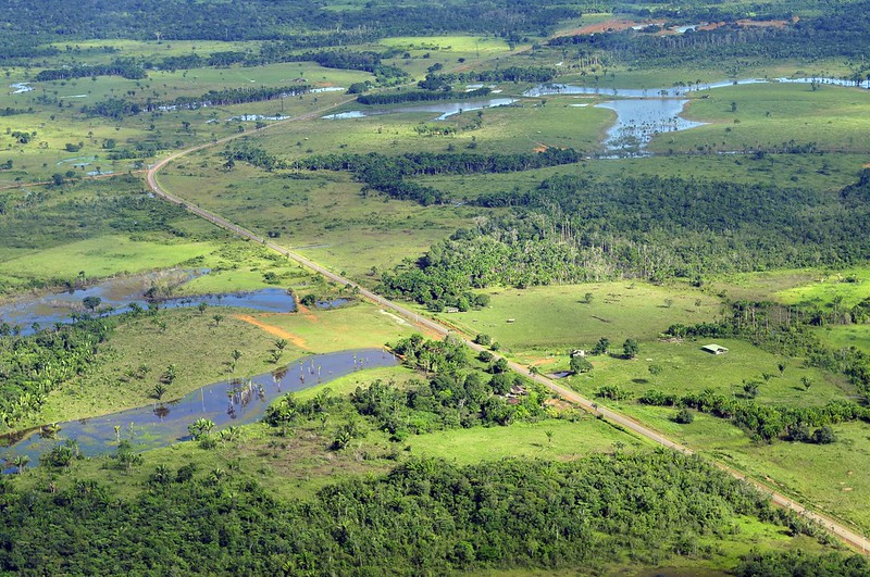
A groundbreaking study using satellite data and an artificial intelligence algorithm shows how the spread of unofficial roads throughout the Amazon is driving widespread deforestation.
One such road is on the verge of cutting across the Xingu Socioenvironmental Corridor, posing a serious risk of helping push the Amazon beyond a crucial tipping point.
Unprotected public lands account for 25% of the total illegal road network, with experts saying the creation of more protected areas could stem the spread and slow both deforestation and land grabs.
Officially sanctioned roads, such as the Trans-Amazonian Highway, also need better planning to minimize their impact and prevent the growth of illegal offshoots, experts say.
The Americas have a long history of occupation based on the destruction of nature and the violent massacre of native peoples, all in the name of a particular idea of “progress.” Brazil’s military dictatorship, which ran from 1964 to 1985, embraced this ideology to the point it had a specific motto — “integrate to not surrender” — for its nationalist project for the Amazon Rainforest. That mindset is still alive in the systemic and uncontrolled spread of unofficial roads in the Amazon, and the extent of this destruction is becoming increasingly clear.
A study by the Brazilian conservation nonprofit Imazon identified 3.46 million kilometers (2.15 million miles) of roads in what’s known as the Legal Amazon, an administrative region that spans the nine Brazilian states located within the Amazon Basin. The researchers estimated that at least 86% of the extent of these roads are unofficial, “built by loggers, goldminers, and unauthorized land settlements from existing official roads.” The sprawling network of roads also means that 41% of the Amazon Rainforest is already cut by roads or lies within 10 km (6 mi) of one.
While two-thirds of the road extent identified in the study is on private properties and settlements, the other third is on public lands. Here, unofficial roads have mushroomed, particularly in public areas without special protection from the government. The roads in these public areas run 854,000 km (531,000 mi), accounting for a quarter of the total in the Amazon.
According to Imazon, roads in these areas point to criminal activities such as illegal logging, mining, and land grabbing. The study also shows that 5% of the road network is inside conservation units, and 3% within Indigenous territories, running a total 280,000 km (174,000 mi) inside these ostensibly protected areas.
“These are arteries of destruction,” study co-author Carlos Souza Jr., an associate researcher at Imazon who coordinates the institute’s Amazon monitoring program, told Mongabay by phone. “The roads are opened to extract wood, and the ramifications spread from the main line, where the trucks and heavy machinery are.” He added the degradation is followed by the occupation of these areas, in what’s become a very familiar pattern in the Amazon.
According to Souza, previous studies estimated the length of official roads at around 80,000 km (nearly 50,000 mi) in the Brazilian Amazon, composed of federal, state and municipal highways and roads in official settlements, all of which are part of the planned infrastructure.
But the official numbers are much lower. The Federal Department for Transport Infrastructure (DNIT) told Mongabay in an email that it acknowledges 23,264 km (14,455 mi) of paved and unpaved roads within the Legal Amazon. That’s a tiny fraction of the more than 3 million km of mostly undocumented roads that Imazon identified in the region.
“Roads created without planning by municipalities, states and the federal government don’t appear on official maps,” Souza said, “but they end up being incorporated into the municipal network, demanding public money for their maintenance.”
The Imazon study, published in July in the journal Remote Sensing, used 2020 images from the Sentinel-2 satellite made available by the European Space Agency. The researchers applied an artificial intelligence algorithm created by Imazon to analyze the images.
Past efforts at making out roads in stacks of satellite images took researchers months of poring over the pictures. This time around, Imazon’s algorithm cut the analysis time to just seven hours, allowing the researchers to focus on the data. Studies using the previous methods had already indicated that the advance of unofficial roads was a driver of deforestation in the Amazon, but the new research will allow scientists to recreate a historical series with data from previous years using the new algorithm for the entire Amazon region.
Souza said mapping and monitoring the spread of roads is crucial to identifying threats to the forest, its people, and traditional communities. Previous studies have already shown that 95% of deforestation happens within 5.5 km (3.4 mi) of a road, and 85% of fires each year occur within 5 km (3.1 mi). Accounting for only the official road network, deforestation would be at least 50 km (31 mi) from the nearest road, and fires 30 km (18.6 mi) away.
“That proves mapping clandestine roads improves deforestation and fire risk prediction models and can be used as a tool to prevent forest destruction,” Souza said. “Monitoring usually looks for deforestation after the forest has already been cut down. If monitoring focuses on roads, the potential to prevent deforestation is huge.”
Souza and the team at Imazon are also building a network to deploy their tool in tropical forests worldwide to map the road footprint in other areas under pressure, such as the Congo Basin and Indonesia. PrevisIA, a deforestation prediction tool, is already using the new database. According to the latest analysis by Imazon, 75% of deforestation occurred within 4 km (2.5 mi) of PrevisIA’s predictions.
Both by length and density (the ratio between the area covered and the length of the road), unofficial roads in the Amazon are concentrated in the states of Mato Grosso, Pará, Tocantins, Maranhão and Rondônia. The data show that the zone known as the “arc of deforestation,” on the southeastern edge of the biome, continues to be the most targeted, but also points to a surge in the south of Amazonas state, western Pará, and the Terra do Meio region in central Pará.
Souza said that while most roads are very well maintained in private areas and with no public access, regulatory bodies such as the DNIT should work with environmental protection agencies to restrict traffic on these roads.
An imminent threat
An example of an illegal road that presents a danger to one of the most extensive contiguous forests in the Amazon was detected by Rede Xingu+, a network of conservation NGOs. The organization spotted an unofficial road running 42.8 km (26.6 mi) across two important conservation areas: the Terra do Meio Ecological Station and the Iriri State Forest. The road threatens to divide the Xingu Socioenvironmental Corridor, a 28-million-hectare (69-million-acre) swath of native forest that’s home to 21 Indigenous territories and nine conservation units.
According to the Instituto Socioambiental (ISA), an NGO that advocates for environmental and Indigenous rights, the illegal road starts in a deforestation hub inside the Triunfo do Xingu Environmental Protection Area. From there, it’s on the verge of completing the connection between the municipalities of Novo Progresso and São Felix do Xingu, a center for the illegal timber and gold trades. With just 10 km (6 mi) of forest to cut through in Iriri, the road could soon reach the Curuá River, inside the state forest, completing the connection and slicing right through the Xingu corridor, increasing the vulnerability of its forests dramatically.
“The threat is imminent,” Thaise Rodrigues, a geoprocessing analyst at the ISA, told Mongabay by phone, “and so far we are not aware of any legal action to stop it.” Rede Xingu+ spotted the road for the first time in January this year. Its progress was interrupted for a few months when it reached a mine inside the Terra do Meio Ecological Station. As of May this year, work on the road resumed, and it reachedthe Iriri State Forest. In July and August, the monitoring showed 575 hectares (1,420 acres) of deforestation around this road.
“When a large mass of forest is broken, it becomes vulnerable. The roads cause fragmentation, which intensifies deforestation,” Rodrigues said. The ISA has criticized both the Pará state and the federal governments for their inaction, given that both are responsible for the protected areas inside the Xingu corridor. The illegal road increases what’s known as the “edge effect,” where areas of forest exposed to clearings such as roads become more vulnerable to threats. And the deforestation wrought by these threats drives the Amazon closer toward a “tipping point,” beyond which the rainforest loses its ability to self-regenerate and devolves into a dry savanna.
According to the ISA, the Xingu corridor holds an estimated 16 billion metric tons of carbon dioxide, and its mass of lush vegetation is responsible for generating the “flying rivers” of water vapor that bring rain to the rest of the continent. Splitting up swaths of forest with roads also causes a loss of connectivity, which directly impacts the migration of aquatic and terrestrial wildlife, while accelerating the desertification of the soil. The ISA points to another serious risk: opening up the rainforest brings humans closer to the 3,000 known coronavirus species that Amazonian bats carry, making another global pandemic ever more likely.
Near the Iriri State Forest, the Baú Indigenous Territory is already under heavy pressure from mining activities and the deforestation front advancing from the municipality of Novo Progresso.
“The greater the network of roads around and inside protected areas,” Rodrigues said, “the greater the access for the consolidation of such illegal activities.”
She added that unprotected public areas are even more susceptible to land grabs. “The delimitation of protected areas would help, but the public authorities need to show interest in protecting these areas and the communities that live there.”
Imazon’s Souza said the creation of protected areas is the fastest way to contain the spread of these roads, since there’s little chance of land grabbers gaining legal title to the land that’s designated as protected.
“Deforestation is an expensive business,” he said, “and nobody will spend money if there’s no chance of owning that land in the future.” That applies even to areas where roads have already been cut, since that would make them less appealing to speculators.
Official roads are also risks
Experts say Brazil should also rethink the construction of government-built roads. One example is the BR-230, a project conceived under the military dictatorship that’s become a problem child for successive administrations. Construction of the road, known as Trans-Amazonian Highway, began in 1969, and it was inaugurated in 1972 despite not having been completed. Today, it cuts more than 4,000 km (2,500 mi) through the Amazon from Brazil’s northeast coast, with long stretches still unpaved and rendered completely impassable during the rainy season. The combination of cost, logistics, and the inherent difficulty of building colossal infrastructure in the middle of the forest have meant it’s still uncompleted 50 years after its inauguration.
Besides the Trans-Amazonian Highway, there’s the BR-163, which connects Cuiabá, in Mato Grosso, to Santarém, in northern Pará; and the BR-319, from Manaus, in Amazonas, to Porto Velho, in Rondônia. Both are expected to cut across the Brazilian Amazon in different directions. Experts say that despite being officially sanctioned projects, the precarious planning behind them compounds the risks to the region’s environment.
A 2020 study evaluated 75 road projects in the Amazon, including in Brazil, Bolivia, Colombia, Ecuador and Peru, composed of 12,000 km (nearly 7,500 mi) of planned roads. It showed that, if carried out over the next 20 years, the roads would cause the deforestation of 2.4 million hectares (5.9 million acres) of forest. Besides the environmental damage linked, 45% of the projects would also generate economic losses. Canceling these unfeasible projects would save $7.6 billion and 1.1 million hectares (2.7 million acres) of forests, the study showed.
It also made the case that carefully picking a smaller number of projects could achieve 77% of the economic benefits with only 10% of the socioenvironmental damage.
“Every project will cause environmental damage to some degree,” study co-author Thaís Vilela, a senior economist at the Washington, D.C.-based Conservation Strategy Fund, told Mongabay in an email. “But there is a subset of projects that have a positive financial return with lower environmental and social impacts.”
The research considered variables such as the project’s initial cost, deforestation, ecological relevance of the area, access to schools and health centers, and breaches of environmental regulations.
“Often, decision makers only consider the financial costs and benefits of the project,” Vilela said, “and there are political demands that often do not follow the economic logic.”
The research shows that the economic prospects of a project go from positive to negative when the potential environmental and social impacts are accounted for. To pave 2,234 km (1,388 mi) of the Trans-Amazonian Highway, for instance, 561,000 hectares (1.38 million acres) of forest would be destroyed. In terms of the impact on biodiversity, water, carbon storage, and the integrity of protected areas, BR-163, BR-230, and BR-319 would do the most significant damage to the environment, the study found. Paving 496 km (308 miles) of BR-163 alone would cause 400 million metric tons of carbon dioxide emissions by 2030.
As dire as these figures look, the true extent of the damage would be even greater because of the unofficial roads that would sprout off these main highways, the study authors said. Construction and improvement of these primary roads, they wrote, “might potentially lead to the construction of secondary, tertiary, and even illegal roads in the region, promoting additional impacts.”.
“Unofficial roads usually come from official ones,” Imazon’s Souza said. He blamed poor environmental impact assessments for allowing this proliferation of roads, adding that the major official highways also harm protected areas and Indigenous territories.
“There are areas where roads should not be built, as environmental and social damage would be greater than potential benefits,” Vilela said. “Ideally, the definition of these variables should involve all individuals directly affected by the project.”
The DNIT told Mongabay that its responsibility is limited to federal roads listed in the National Road System database, which doesn’t include unofficial roads. Mongabay also contacted IBAMA, the Brazilian environmental protection agency, and ICMBio, the government institute that oversees protected areas, but didn’t receive any response to requests for comment by the time this story was published.
Citations:
Botelho, J., Costa, S. C., Ribeiro, J. G., & Souza, C. M. (2022). Mapping roads in the Brazilian Amazon with artificial intelligence and Sentinel-2. Remote Sensing, 14(15), 3625. doi:10.3390/rs14153625
Barber, C. P., Cochrane, M. A., Souza Jr, C. M., & Laurance, W. F. (2014). Roads, deforestation, and the mitigating effect of protected areas in the Amazon. Biological Conservation, 177, 203-209. doi:10.1016/j.biocon.2014.07.004
Vilela, T., Malky Harb, A., Bruner, A., Laísa da Silva Arruda, V., Ribeiro, V., Auxiliadora Costa Alencar, A., … Botero, R. (2020). A better Amazon road network for people and the environment. Proceedings of the National Academy of Sciences, 117(13), 7095-7102. doi:10.1073/pnas.1910853117