by Deep Green Resistance News Service | Mar 16, 2012 | Climate Change, NEWS
By Environment News Service
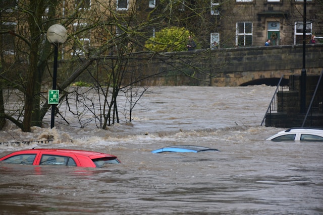
Nearly four million Americans are at risk of severe flooding as climate change raises sea levels and intensifies storm surges during the coming century, new research indicates.
Two studies, published today in the journal “Environmental Research Letters,” provide evidence that sea levels are rising, creating higher and higher floods that will inundate much of the low-lying coastal United States.
Ben Strauss, a researcher at the nonprofit Climate Central who co-authored both papers, said, “The sea level rise taking place right now is quickly making extreme coastal floods more common, increasing risk for millions of people where they live and work.”
“Sea level rise makes every single coastal storm flood higher,” said Strauss. “With so many communities concentrated on U.S. coasts, the odds for major damage get bigger every year.”
The first study, by researchers at Climate Central and the University of Arizona, finds that around 32,000 square kilometers (12,355 square miles) of U.S. land lies within one vertical meter of the high tide line.
This area encompasses about 2.1 million housing units where 3.9 million people live.
For this study, the researchers created a new model to identify the areas of the U.S. mainland that are at risk of flooding. With a predicted sea level rise of one meter (39 inches) or more by the end of the century, this study suggests that the U.S. government’s currently designated flood zones should not be considered stable.
This study demonstrates that coastal dwellings on every coast are exposed to this risk. At the state level, areas surrounding the Gulf of Mexico appear to be the most vulnerable. In terms of population, Florida is the most vulnerable, followed by Louisiana, California, New York and New Jersey.
The Los Angeles metropolitan area is of great concern, the researchers warn, citing previous studies suggesting that flooding may reach rare heights more swiftly in southern California than in any other U.S. mainland area.
Read more from Environment News Service:
Photo by Chris Gallagher on Unsplash
by Deep Green Resistance News Service | Mar 11, 2012 | Biodiversity & Habitat Destruction, Colonialism & Conquest, Indigenous Autonomy
By Edward Helmore / The Guardian
Of the many projects commissioned by the Obama administration to showcase its commitment to renewable energy, few are as grandly futuristic as the multibillion-dollar solar power projects under construction across broad swaths of desert on the California-Arizona border.
But at least two developments, including the $1bn, 250-megawatt Genesis Solar near Blythe in the lower Colorado river valley and the Solar Millennium project, are beset with lengthy construction delays, while others are facing legal challenges lodged by environmental groups and Native American groups who fear damage to the desert ecology as well as to ancient rock art and other sacred heritage sites.
Out on the stony desert floor, Native Americans say, are sites of special spiritual significance, specifically involving the flat-tailed horned toad and the desert tortoise.
“This is where the horny toad lives,” explains Alfredo Figueroa, a small, energetic man and a solo figure of opposition who could have sprung from the pages of a Carlos Castaneda novel, pointing to several small burrows. Figueroa is standing several hundred metres into the site of Solar Millennium, a project backed by the Cologne-based Solar Millennium AG. The firm, which has solar projects stretching from Israel to the US, was last month placed in the hands of German administrators and its assets listed for disposal.
Figueroa is delighted with the news. “Of all the creatures, the horny toad is the most sacred to us because he’s at the centre of the Aztec sun calendar,” he says. “And the tortoise also, who represents Mother Earth. They can’t survive here if the developers level the land, because they need hills to burrow into.”
Figueroa, 78, a Chemehuevi Indian and historian with La Cuna de Aztlán Sacred Sites Protection Circle, has become one of the most vocal critics of the solar programme and expresses some unusually bold claims as to the significance of this valley: he claims it is the birthplace of the Aztec and Mayan systems of belief. He points out the depictions of a toad and a tortoise on a facsimile of the Codex Borgia, one of a handful of divinatory manuscripts written before the Spanish conquest.
On a survey of the 2,400-hectare site Figueroa points out a giant geoglyph, an earth carving he says represents Kokopelli, a fertility deity often depicted as a humpbacked flute player with antenna-like protrusions on his head. Kokopelli, he says, will surely be disturbed if the development here resumes.
The area is known for giant geoglyphs, believed by some to date back 10,000 years. Gesturing towards the mountains, he also describes Cihuacoatl – a pregnant serpent woman – he sees shaped in the rock formations. All of this, he says, amounts to why government-fast-tracked solar programmes in the valley, where temperatures can reach 54C, should be abandoned. It is a matter of their very survival.
“We are traditional people – the people of the cosmic tradition,” Figueroa explains. “The Europeans came and did a big number on us. They tried to destroy us. But they were not able to destroy our traditions, and it’s because of our traditions and our mythology that we’ve been able to survive. If we’d blended in with the Wasps – the white Anglo-Saxon Protestants – we’d have been lost long ago.”
At the Genesis Solar site, 20 miles west, Florida-based NextEra has begun to develop an 810-hectare site. The brackets that will hold the reflecting mirrors stand like sentinels. Backed by a $825m department of energy loan, Genesis Solar is planned as a centrepiece of the administration’s renewable energy programme, with enough generating capacity to power 187,500 homes.
But local Native American groups collectively known as the Colorado River Indian Tribes are demanding that 80 hectares of the development be abandoned after prehistoric grinding stones were found on a layer of ashes they say is evidence of a cremation site “too sacred to disturb”.
Read more from The Guardian: http://www.guardian.co.uk/environment/2012/mar/11/solar-power-mojave-desert-tribes
by Deep Green Resistance News Service | Mar 8, 2012 | Toxification
By Krishna Ramanujan
A new report has found dozens of cases of illness, death and reproductive issues in cows, horses, goats, llamas, chickens, dogs, cats, fish and other wildlife, and humans. It says these conditions could be the result of exposure to gas drilling operations.
Hydraulic fracturing, popularly called hydrofracking, is a process for extracting natural gas from shale using chemicals and water.
The paper’s authors, Robert Oswald, a professor of molecular medicine at Cornell’s College of Veterinary Medicine, and veterinarian Michelle Bamberger, DVM ’85, interviewed animal owners in six states — Colorado, Louisiana, New York, Ohio, Pennsylvania and Texas — and cited 24 cases where animals were potentially affected by gas drilling.
According to the study, recently published online and appearing soon in print, in New Solutions: A Journal of Environmental and Occupational Health Policy, making a direct link between death and illness is not possible due to incomplete testing, proprietary secrecy from gas drilling companies regarding the chemicals used in hydrofracking, and non-disclosure agreements that seal testimony and evidence when lawsuits are settled.
“We have a number of case studies — they don’t tell us about the prevalence of problems associated with hydraulic fracturing, but they do tell us how things can happen,” said Oswald.
Some of the case studies include:
- In Louisiana, 17 cows died within an hour of direct exposure to hydraulic fracturing fluid. A necropsy report listed respiratory failure with circulatory collapse as the most likely cause of death.
- A farmer separated his herd of cows into two groups: 60 were in a pasture with a creek where hydrofracking wastewater was allegedly dumped; 36 were in separate fields without creek access. Of the 60 cows exposed to the creek water, 21 died and 16 failed to produce calves the following spring. None of the 36 cows in separated fields had health problems, though one cow failed to breed in the spring.
- Another farmer reported that 140 of his cows were exposed to hydrofracking fluid when wastewater impoundment was allegedly slit, and the fluid drained into a pasture and a pond. “These farmers saw workers slitting the liner to decrease the amount of liquid in the impoundment in order to refill it,” said Bamberger. “We have heard it now on several occasions.” Of the 140 cows, about 70 died, and there were high incidences of stillborn and stunted calves.
The authors note that the “most striking finding” of their study was how difficult it was to get solid information on the link between hydrofracking and health effects.
To provide better assessments of health impacts, the researchers recommend:
- prohibiting nondisclosure agreements when public health is at stake;
- increasing food safety testing and research, as the study documented that animals exposed to chemicals were not tested prior to slaughter, and little is known about the effects of hydrofracking chemicals on meat and dairy products;
- improving the monitoring of routes of exposure, including in water, soil and air; and, most importantly,
- fully testing the air, water, soil and animals prior to drilling and at regular intervals after drilling is completed, and disclosing fully the chemicals used when hydrofracking.
“Without knowledge of all the chemicals being used, you can’t test before drilling,” said Bamberger. “And if we don’t have predrilling tests then if you find a chemical postdrilling, how can you prove that” it came from hydrofracking, she added.
From Physorg: http://www.physorg.com/news/2012-03-reproductive-problems-death-animals-exposed.html
by Deep Green Resistance News Service | Mar 8, 2012 | Agriculture, Listening to the Land
By Ann Perry
U.S. Department of Agriculture (USDA) scientists are studying the overall improvement in water quality when native prairie vegetation is restored to fields once cropped with corn and soybeans. Agricultural Research Service (ARS) scientists in Ames, Iowa, were part of a team that examined changes in groundwater during prairie establishment at the Neal Smith National Wildlife Refuge near Prairie City, Iowa. ARS is USDA’s chief intramural scientific research agency.
ARS researchers Mark Tomer and Cynthia Cambardella work at the agency’s National Laboratory for Agriculture and the Environment in Ames. Their group studied concentrations of nitrates and phosphorus in groundwater in a 17-acre field that was being converted from corn and soybean row-cropping into a reconstructed prairie. The researchers set up groundwater monitoring wells and collected water samples from 2002 through 2009.
After a final soybean harvest in 2003, the field was seeded with native grasses and forbs. As the prairie became established, nitrate concentrations in groundwater samples declined and stabilized within five years. Initially, nitrate levels in groundwater samples taken at higher slopes averaged 10.6 parts per million (ppm), levels that can fuel the downstream development of the “dead zone” in the Gulf of Mexico.
But nitrate levels in groundwater samples taken near surface waterways averaged only 2.5 ppm, and after 2006, nitrates disappeared from the shallow groundwater near the waterways. Further upslope, groundwater samples still had measurable nitrate levels in 2006, but levels diminished to around 2 ppm after 2007.
Unlike nitrate, however, phosphorus levels did not decline. Between 2006 and 2009, phosphorus concentrations averaged 0.14 ppm along the ephemeral waterways, while average upland concentrations were only around 0.02 ppm. The higher phosphorus concentrations were found in shallow groundwater wells adjacent to grass waterways. When groundwater levels rose enough to produce overland flows that contribute to stream flow, the phosphorus concentrations were high enough to threaten local water quality.
From Physorg: http://www.physorg.com/news/2012-03-prairie-quality.html
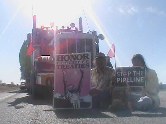
by Deep Green Resistance News Service | Mar 7, 2012 | Indigenous Autonomy, Obstruction & Occupation
By Chase Iron Eyes / Last Read Indians
March 5th, 2012, everyone had their ear to the new moccasin telegraph. Social networks, telephones, and word of mouth networks were abuzz with reports of Oglala Lakota Nationals preventing oil pipeline materials, destined for Canadian Tar sands and/or Keystone XL infrastructure locales or some unknown destination, from being transported across the Pine Ridge Reservation’s Treaty territory. Information travelled to Debra and Alex White Plume (Owe Aku, Inc. “Bring Back the Way) and Olowan Martinez that semi-trucks loaded with enormous oil pipeline components were set to cross Oglala territory sometime during the afternoon on March 5th, 2012; “We did not know where the equipment was going, but we knew that these trucks were too huge, too heavy, and too dangerous to pass our roads. We thought the equipment may be going to the Tarsands oil mine, or other oil mines in Canada,” Debra White Plume explained.
A call went out via digital media and other sources for all able bodied and willing participants to mobilize and report to Wanblee, South Dakota, for an impromptu gathering of scores of activists ready to block the road with their bodies to prevent semi-trucks and pipeline components from crossing Oglala Territory. Within minutes the confrontation happened as several State and Tribal police officers and other officials responded to the tense scene. Oglala Tribal police arrived immediately with one Sergeant telling the road-blockers that the South Dakota Highway Patrol was parked a few miles down the road at the border between Oglala Country and the State of South Dakota but that the SD Highway Patrol would not proceed onto the reservation. Notably, this Sergeant also advised those present that the FBI (Federal Bureau of Investigation) was en route to the reservation in two vans from Rapid City, SD. However, at the conclusion of the day there were no signs of such FBI presence.
The Texas semi-trucks, transporting 1.25 Million-dollar “Treater Vessels” used in oil, gas and element separation, were stopped in their tracks as they approached the human roadblock. The human roadblock that featured two Lakota grandmothers: Renabelle Bad Cob Standing Bear (in her wheelchair) and Marie Randal (in her 90s). The drivers were questioned by those forming the blockade as to why they were crossing Oglala lands. One of the drivers responded that they did not know they were crossing Indian land, only that they were following company directives regarding their assigned routes and that their Canadian Corporation had received this particular route information as a result of a partnership with the State of South Dakota, whose elected officials have always supported the Keystone XL pipeline. This information prompted Tom Poor Bear (Vice President of the Oglala Lakota Nation) to phone South Dakota State officials in Pierre, SD, inquiring as to the nature and origin of the route of the stopped truckers. South Dakota affirmed to Oglala Vice President Tom Poor Bear that indeed the State was involved with planning such route, ostensibly without consulting the Oglala Lakota Nation. The heavy-hauling trucks were allegedly cutting through Oglala country in attempts to avoid a $50,000.00 per-truck-fee to pass through using State of South Dakota roadways.
Read more from Last Real Indians