Five thousand acres of cloud forest are currently being threatened in Coatepec, Veracruz, Mexico. This land is, at present, being held by squatters, who, with the backing of local politicians, have claimed to be the forest’s rightful owners. They displaced dozens of families and are threatening one of Mexico’s most vital ecosystems. These 5,000 acres of land contain three municipal parks and one archeological site. While the land’s original stewards and forest protectors are engaged in a legal battle with the “invaders,” the deforestation of this fragile ecosystem has already commenced. This act of environmental devastation has wide political/economic ramifications. If you control Coatepec’s mountains, you control the subsistence and livelihood of millions.
The Coatepec Cloud Forest
The cloud forest above Coatepec is known as “la fabrica de agua” (the water factory). It is one of the last “water factories” of its kind in Mexico, and it moderates the weather of the entire region. The clouds that roll in from the Gulf of Mexico are captured by the forest canopy, the moisture forming a thick mist that shrouds the mountainside. Trees, moss, and orchids collaborate in an infinitely diverse ecosystem to retain the water that feed the region’s rivers, bringing life to the valleys bellow. The cities of Coatepec, Xalapa, and Cardel rely on this water, not to mention most of the communities of central Veracruz.
Globally, cloud forests are bastions of biodiversity. They harbor animal, and plant that are threatened by the shifting tides of the climate crises and uncontrolled land use. Coatepec’s cloud forest now hosts 90 plant, animal, and fungal species on the verge of extinction. Coupled with the biodiversity loss, the destruction of this ecosystem holds serious repercussions for the entire watershed. Without the cloud forest, the rivers will run dry, and the entire region will see considerably less rainfall. In short, the destruction of the cloud forest will spell drought and devastation for all.
The Invasion
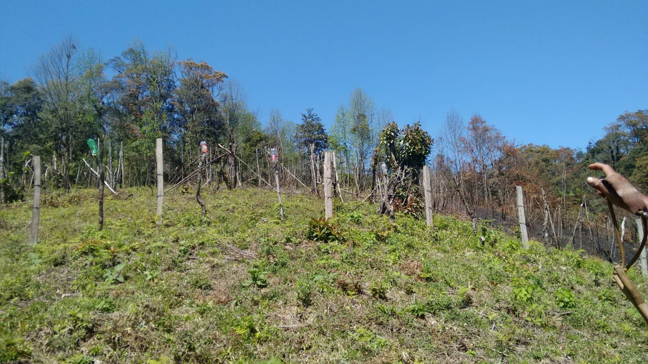
In January 2019, a faction of the “Central Independiente de Obreros Agrícolas y Campesinos” (The Independent Organization of Agricultural Laborers and Farmers) set up an encampment on the 2,000 acres of cloud forest known as the Jinicuil Manso estate. CIOAC verbally threatened more than 500 original stewards of the land and claimed to be the legal owner of the property. While the information is difficult to corroborate, local activist networks say that the organizers of the CIOAC encampment came from outside the region, and do not hold legal rights to the said property. The community members who own land in the Jinicuil Manso estate submitted complaints to the local authorities. While the government “invited” the squatters to move off the premises, they requested that the community members refrain from engaging directly with CIOAC, to prevent physical aggression.
The situation was further complicated in February 2020, when the local authorities issued a “measurement and demarcation notice,” requesting that all the landowners submit paperwork confirming their title to the land. Many of the land’s stewards were not aware of the government’s decree. Others did not have the paperwork to prove that they owned their properties, even though the land had been in their family for generations. The local government never specified the reasons for this “demarcation notice,” and never compared the documents submitted by the land’s stewards with those provided by CIOAC. Instead, they refused to consider the documents submitted, and appear to favor CIOAC’s land claim, a land claim that local activists argue has been falsified.
The Electoral Politics of Water and Land
The local community groups, such as “Por la Defensa de la Sierra de Coatepec,” and the individual landowners, are currently involved in court cases with CIOAC. Throughout the process, it has it became clear the larger political forces are involved in the illegal “settlement” of the cloud forest. The CIOAC members have direct connection with major political parties in the area, with whom they have garnered ample political support. In addition, they have publicly thanked the governor of the State of Veracruz, Cuitlahuac García Jiménez, for his backing (though it is unclear whether this was just political posturing on the part of CIOAC).
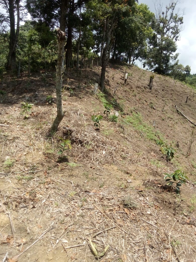
Land, environmental destruction, and electoral politics has been devastatingly intertwined in Mexico for decades. When CIOAC first “invaded” the cloud forest, they invited citizens from the surrounding regions to squat on the appropriated land. Community members who did not own land of their own, and/or were seeking greater financial stability, settled in the cloud forest. Forest protectors have observed between 100 to 300 community members in the encampments at a time. They cut down trees, hunt the local fauna, and set up their septic systems to run off into the precious streams. When forest protectors attempt to plant trees or talk with the squatters, the squatters respond violently. They have been known to brandish guns and machetes, defending the land that has been promised to them.
Political figures from various parties in the region have sought to partner with the CIOAC settlers, nurturing a solid voting block of support. Leading up to the future regional and national elections, the ruling political parties have reacted favorably to the CIOAC’s land claims. However, underneath the surface, the forest protectors and activists claim that there is an even darker story. The people that live in the encampments of Jinicuil Manso could also be serving as a human shield, emptying the land for a larger economic interest that seeks to control the most vital resource of all: water.
The Conquest of the Cloud Forest
While at first glance the squatters could appear to be land hungry farmers, they are in fact just a cog in the virulent political system. Local activists believe that the squatters could be a facade for a political and economic interest that seeks to take over the forest of the region. Nestle, Coca-Cola, and other international corporations have huge factories in Coatepec, and have been seeking to control the region’s water supply for decades. Over the last series of elections, the community members have seen this same political/environmental ploy play out, though not to this level of devastation.
Veracruz is one the deadliest regions for land and water protectors in the world. “Por la Defensa de la Sierra de Coatepec” continues to organize throughout the region, raising awareness about the plight of the cloud forest, and the people that have been displaced. However, the settlers began threatening the lives of the forest protectors. When the organizers tried to negotiate with them in person, they were attacked with machetes. In the end, the CIAOC managed to scare most of the forest protectors into silence by actively threatening their families, while local authorities have turned a blind eye.
Action
While many forest protectors are too afraid to speak in public or to the press, the fight is not over. On the 29th of November 2020, “Por la Defensa de la Sierra de Coatepec” will return to the stolen land to begin reforesting the trees that have been cut down. They will also initiate a barter market with the local community members who have been directly affected by the theft of land. While many forest protectors have been forced to move to surrounding cities to protect their families, they are willing to risk their lives to defend and bring life back to the cloud forest.
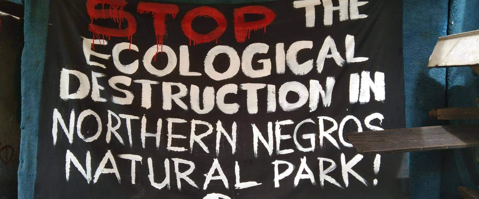
This article is based on communication from a comrade in the Negros province of the Philippines. There is ongoing destruction of the natural world in this area due to road construction, a planned airport, and clearing of the rainforest. The people on the front lines, being most affected, are calling for international solidarity and support.
On October the 18th this year, the first direct action regarding the Northern Negros National Park was taken by a group of concerned people. Food Not Bombs Bacolod Volunteers and concerned citizens have started a campaign to raise awareness about the ongoing destruction of the rainforest in the Negros area of the Philippines. The group has begun disseminating information to ensure other know about the ongoing harm being caused and to stand firmly IN SOLIDARITY WITH THE FOREST.
The group, focused their work in the city of Bacolod distributing printed placards, information flyers & leaflets and have been clear they are in direct opposition to any act of destruction. Food Not Bombs Bacolod condemns these injustices and the actions of the Local Government of Negros Island which sanctions the destruction of the remaining rainforest of the island.
The Northern Negros Natural Park is a protected area of the Philippines located in the northern mountainous forest region of the island of Negros in the Visayas. It is spread over five municipalities and six cities in the province of Negros Occidental and is the province’s largest watershed and water source for seventeen municipalities and cities including the Bacolod metropolitan area.
The park belongs to the Negros–Panay Biogeographic Region. It is one of two remaining lowland forests on Negros island, the other being in the Dumaguete watershed area in Mount Talinis on the southern end of the island in Negros Oriental.
The park is a habitat to important fauna including the Visayan spotted deer, Visayan warty pig, Philippine naked-backed fruit bat, and the endangered Negros shrew.
Number of endemic and threatened species of birds have been documented in the park, which includes the Visayan hornbill, Negros bleeding-heart, white-winged cuckooshrike, flame-templed babbler, white-throated jungle flycatcher, Visayan flowerpecker and green-faced parrotfinch.
Flora documented within the park include hardwood tree species (Dipterocarps), as well as palms, orchids, herbs and trees with medicinal value. Very rare is the local species of the cycas tree (locally called pitogo), probably a Cycas vespertilio, considered living fossil from the times of dinosaurs. Another prehistoric flora is present in the park like the tree ferns and the also protected Agathis philippinensis, (locally known as almaciga).
While We Were Distracted
As we know during 2020 most nations have been preoccupied trying to survive lockdown. During this time the local government of Negros Island, Protection And Management Board, Department of Environment and Natural Resources (DENR) failed in its responsibilities to protect the remaining watershed and rainforest. Road construction on the island started in the midst of Global Pandemic.
Instead the DENR legitimized the road construction on the Island and in doing so has increased the likelihood of communities on the island being destroyed in the medium to long term. The DENR, along with the Department of Public Works and the Department of Highways have acted in a way that swept aside the needs of local communities, that ignored the rights of the natural world and in doing so have colluded to strengthen their power. In short they have become the mechanism and tool of destruction for the island.
The Aerotroplis Project
The plans to build a new International Airport in Manila has also hit the radar of environmental activists. The people and environmental groups in Bulakan and Bulacan have shared concerns about the devastation this will cause to the natural world, to wildlife (including fish) populations, bird populations, air pollution, and airplanes flying in the sky. As always the focus is on economic benefits rather than the health of planet or people. There has been little or no analysis of the environmental impact.
Leon Dulce, national coordinator of Kalikasan-People’s Network for the Environment (Kalikasan-PNE), told the BusinessMirror that the presence of the bird populations are bioindicators of good ecological health. He stated “This is of crucial importance in these times when there are multiple epidemiological risks from pandemics, socioeconomic loss, and climate emergency all emerging from the disrupted environment. Massive land-reclamation activities in Manila Bay threatens the last remaining wetlands where migratory birds roost. The Bulacan Aerotropolis is one of the biggest threats that will destroy 2,500 hectares of mangroves and fisheries. It is outrageous that transportation mega infrastructure is being touted for economic recovery when global transportation is expected to remain disrupted until 2021.”
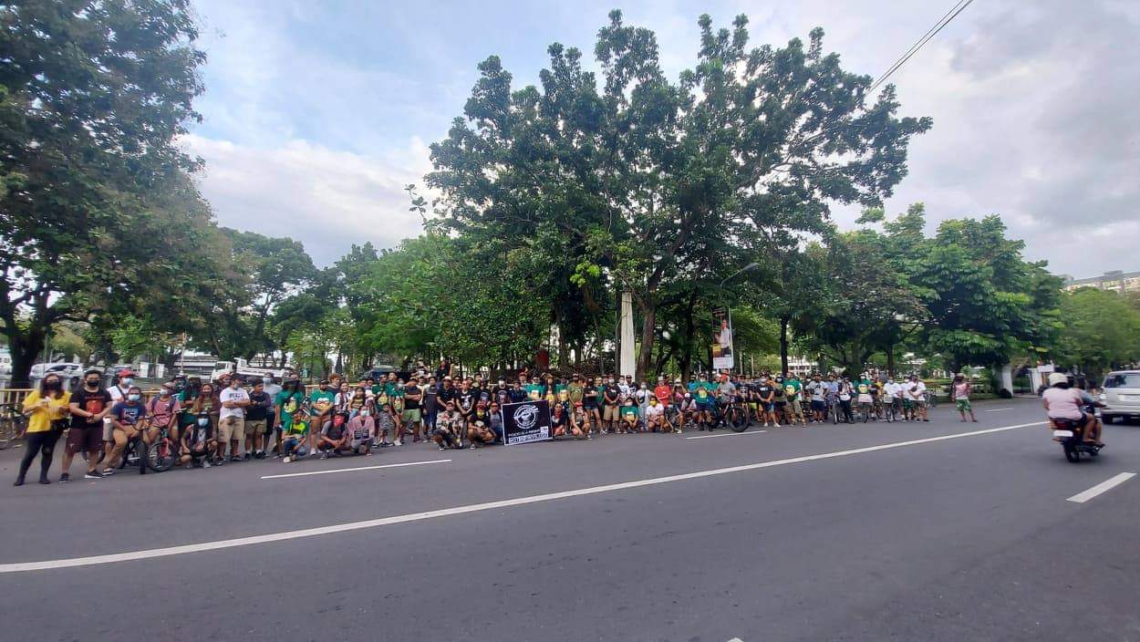
Critical Mass Ride
Following the actions from Food Not Bombs Bacolad, on November 8th Local Autonomous Networks held a discussion to consider the ongoing problem. They agreed to organize a coordinated Critical Mass Ride. The ride involved concerned people in the Archipelago from the different islands of the Philippines gathering to travel around the main city to raise awareness.
Food Not Bombs and Local Autonomous Networks have issued a call to action to support them in opposing the road construction and the subsequent destruction of the Rainforest that will kill the livelihood of hundreds of families.
The call to action in the Archipelago is just a start. They have been clear they will not stop nor be silenced until the destruction planned has been stopped. They are calling for International Solidarity to all readers.
Join The Resistance. Join The Fight!
Save the Remaining Forest & Watershed of Northern Negros Natural Park, Stop the Patag-Silay-Calatrava-Cadiz Road Construction. STOP the Bulacan Aerotropolis Project.
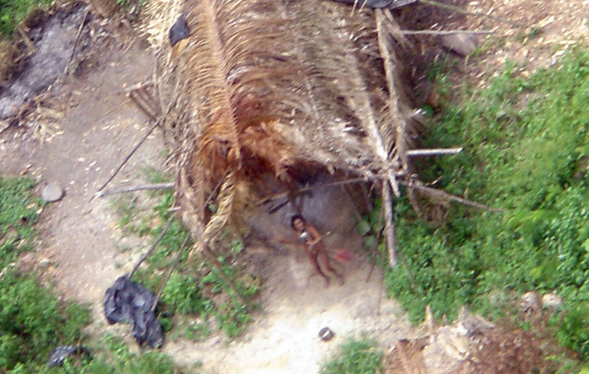
The survival of several uncontacted tribes is now at risk after fires were set inside their territories. Activists have described this year’s Amazon fires, and President Bolsonaro’s war on indigenous peoples, as “the gravest threat to the survival of uncontacted tribes for a generation.”
Four tribal territories face an especially serious crisis:
– The famed Papaya Forest on Bananal Island, the world’s largest fluvial island. It’s inhabited by uncontacted Ãwa people. Eighty per cent of the forest burned in fires last year – fires have been seen this year in one of the last areas of intact forest. More than 100,000 head of cattle now graze on the island.
– The Ituna Itatá (“Smell of Fire”) indigenous territory in Pará state, inhabited exclusively by uncontacted Indians. This reserve was the most heavily deforested indigenous territory in 2019, as land grabbers and cattle ranchers invaded. In the first four months of 2020, another 1,319 hectares of forest were destroyed, an increase of almost 60% compared to the same period last year.
– The Arariboia territory in the eastern Amazon state of Maranhão: uncontacted Awá inhabit this territory, which has already been extensively invaded. Amazon Guardians of the neighboring Guajajara tribe are warning daily that illegal loggers are destroying the forest at alarming rates. (The Ãwa people of Bananal Island and the Awá tribe of Maranhão state are distinct peoples).
– The Uru Eu Wau Wau territory. Uncontacted Indians inside this territory shot and killed famed Amazon expert Rieli Franciscato last month – campaigners fear the group is being forced out of the forest by the invasions.
Many of the fires are being started to clear the rainforest for logging and ranching, and millions of tons of soya, beef, timber and other products are imported into Europe and the US each year.
APIB (the Association of Indigenous Peoples of Brazil) has launched a campaign to highlight the links between Bolsonaro, his agribusiness backers, and the genocidal violence being committed against indigenous peoples across the country. They are asking people and companies around the world to stop buying products that are fuelling the destruction of their territories.
Survival has launched a global action calling on supermarkets in Europe and the US to stop buying Brazilian agribusiness products until indigenous rights are upheld.
Ângela Kaxuyana, spokesperson from COIAB, the Coordination of Indigenous Organizations of the Brazilian Amazon, said: “Land grabbing, deforestation and arson directly threaten the lives of our uncontacted relatives. The destruction of the territories that are their only sources of life, from where they obtain their food (fauna, flora and water), could end in their extermination.” “A grilagem de terra, o desmatamento e os incêndios criminosos ameaçam diretamente a vida dos nossos parentes em isolamento voluntário. A destruição dos territórios que são suas únicas fontes de vida, de onde garantem sua alimentação (fauna, flora e água), podem levá-los ao extermínio”.
Tainaky Tenetehar, one of the Guajajara Guardians who protect the Arariboia reserve for the Guajajara people and their uncontacted neighbors, said today: “We fight to protect this forest, and many of us have been killed doing so, but the invaders keep coming. They have damaged the forest so much in recent years that their fires are now much bigger, and more serious, than before, as the forest is so dry and vulnerable. The loggers must be evicted – only then can the uncontacted Awá survive and thrive.”
Survival’s Senior Researcher Sarah Shenker said: “In many parts of Brazil, uncontacted tribes’ territories are the last significant areas of rainforest left. Now they are being targeted by land grabbers, loggers and ranchers emboldened by Bolsonaro’s open support for them. Consumers in the US and Europe must understand that there’s a direct connection between the food on their supermarket shelves and this genocidal destruction – and act accordingly. Uncontacted tribes are the most vulnerable peoples on the planet, and at the same time nature’s best guardians, by far. We cannot let their land go up in flames.”
In this research excerpt, the latest temporally inter-comparable maps of the terrestrial Human Footprint are presented, as well as an assessment of change in human pressure at global, biome, and ecoregional scales.
Humans have influenced the terrestrial biosphere for millennia, converting much of Earth’s surface to anthropogenic land uses. Nevertheless, there are still some ecosystems that remain free from significant human pressure, thereby providing crucial habitats for imperilled species and maintaining the ecosystem processes that underpin planetary life-support systems. As a consequence, calls for the global identification, monitoring, and retention of the remaining lands that are relatively free of direct anthropogenic disturbance are increasing.
Over the past two decades, cumulative pressure maps that combine remotely-sensed data with survey data are being increasingly used to assess the full range of human pressures on land spatially. These advances have facilitated the mapping of Earth’s remaining marine and terrestrial wilderness, improved measures and estimates of species extinction risk underpinned broader assessments of human impacts on ecosystems and biodiversity and enabled the identification of protected areas and world heritage sites in danger. The results of these mapping efforts are influencing global policy discussions and informing on-the-ground decisions about where to undertake biodiversity conservation action.
Here, we provide the latest global maps of cumulative human pressure for the years 2000, 2005, 2010, and 2013, and use them to assess how changes in human pressure are altering Earth’s terrestrial ecosystems. We used a human footprint threshold of <4 (on 0 – 50 scale) to identify where land is considered ecologically intact (below the threshold) or highly modified and thus ecologically degraded (equal to or above the threshold). Areas below this threshold are ecosystems that may be subject to some level of human pressure (for example low-density transitory human populations or pasture lands grazed at a low intensity), but still contain the majority of their natural habitat and ecological processes.
This threshold has been found to be robust from a species conservation perspective because once surpassed, species extinction risk increases dramatically , and several ecosystem processes are altered.
We assess transitions from intact to highly modified land at global, biome, and ecoregional scales and ascertain which nations contain Earth’s remaining intact systems, and had the greatest amounts of habitat loss. Previous global assessments of human pressure have attempted to identify at risk ecosystems by determining a ‘safe limit’ of biodiversity loss for ecosystem functionality, assessing protection levels, and analysing habitat conversion using land cover. But all of these ignore a broad range of threats that occur beyond land use such as accessibility via roads, railways and navigable waterways, human population density, and light pollution. These pressures have environmental impacts well beyond the local development footprint.
As such, our results provide the latest spatially explicit understanding of the state of human pressure on the natural environment, and how it is changing over time. We show that the human footprint methodology can be continually updated and, when more recent data becomes available, allow for assessment of habitat loss at scales relevant to planning activities.
State of Terrestrial Earth
As of 2013, 55.8 million km2 (41.6%) of Earth’s surface was intact (which includes wilderness, human footprint of <4), and 33.5 million km2 (25.0%) was wilderness (human footprint of <1). The remaining (human footprint of >4) 78.4 million km2 (58.4%) was under moderate or intense human pressure (and therefore highly modified), which was widespread, encompassing over half the area of 11 (or 78.6%) of Earth’s 14 biomes. Temperate broadleaf and mixed forests were the most altered biome, with 11.6 million km2 (91.0%) being highly modified, followed by tropical and subtropical dry broadleaf forests with 2.72 million km2 (90.5%), and Mediterranean forests, woodlands and scrubs with 2.88 million km2 (89.7%). Wilderness areas have all but disappeared in many biomes, for example, only 82,000 km2 (0.81%) remained in temperate grasslands, savannahs, and shrublands, 29,000 km2 (0.96%) in tropical and subtropical dry broadleaf forests, and just 12,000 km2 (1.69%) in tropical and subtropical coniferous forests. Earth’s 14 biomes consist of 795 ecoregions, which represent distinct biotic assemblages and abiotic features (such as landforms) at a finer scale than biomes. We found the entire extent of 46 (5.76%) ecoregions were highly modified. These 46 ecoregions span 10 biomes, with the majority located in tropical and subtropical moist broadleaf forests (n=17, 37.0%), tropical and subtropical dry broadleaf forests (n=6, 13.0%), and temperate broadleaf and mixed forests (n=6, 13.0%). One-quarter of all ecoregions (n=187) have lost all wilderness. The majority of land in tundra, boreal and taiga forests, and deserts and xeric shrubland biomes remains intact. At the ecoregion level, just 52 (6.53%) still have >90% of their land intact, and a mere 21 (2.64%) are >90% wilderness. These ecoregions with >90% wilderness are found in just four biomes, tundra (n = 12), boreal forests/taiga (n = 5), tropical and subtropical moist broadleaf forests (Rio Negro campinarana and Juruá-Purus moist forests), and tropical and subtropical grasslands, savannahs and shrublands (Northwestern Hawaii scrub).
Contemporary changes in human pressure
Between 2000 and 2013, 25.4 million km2 (18.9%) of Earth’s terrestrial surface deteriorated (human pressure increased), while only 8 million km2 (5.96%) improved (human pressure decreased). This increase in human pressure was substantial across 1.89 million km2 of Earth’s intact lands, an area the size of Mexico, that these places can be classified as highly modified (i.e. they transitioned from below to above the human footprint threshold of 4). During the same time period, over 1.1 million km2 of wilderness was lost (human footprint increasing above 1), with 67,000 km2 of that wilderness becoming highly modified (human footprint increasing from below 1 to above 4).
Intact lands were lost in all biomes during the assessment period, with the highest loss occurring in tropical and subtropical grassland, savannah and shrublands (655,000 km2 was lost representing 11.3% of all intact lands within the biome, an area approximately the size of France; Figure 4). The tropical and subtropical moist broadleaf forests and mangrove biomes also lost substantial areas of intact land (559,000 km2, 6.90% and 9,000 km2, 14.7% respectively). While the largest absolute loss of intact lands occurred in savannah and woodland ecoregions, the largest proportional losses occurred in tropical forest ecoregion types. For example, intact areas were completely lost in seven forested ecoregions including the Louisiade Archipelago rainforests (Papua New Guinea), and Sumatran freshwater swamp forests (Indonesia).
In this article Mike Shanahan describes how the denial of extinction crisis ignores widespread, scientific evidence.
Featured Image: Ross Sokolovski via Unsplash
There’s a growing refusal by some groups to acknowledge the ongoing global extinction crisis being driven by human actions, conservation scientists say.
These views are pushed by many of the same people who also downplay the impacts of climate change, and go against the actual evidence of widespread species population declines and recent extinctions.
Scientists say this phenomenon will likely spike again this week, since a major Convention on Biological Diversity report is due to be released.
The authors of a new report on extinction denial advise experts to proactively challenge its occurrence, and present the “cold hard scientific facts.”
Biodiversity scientists are being urged to “fight the creeping rise of extinction denial” that has spread from fringe blogs to influential media outlets and even into a U.S. Congressional hearing. The call to arms came in a paper published in Nature Ecology & Evolution last month by Alexander Lees, senior lecturer in conservation biology at Manchester Metropolitan University, and colleagues.
“Many of the same individuals that routinely seek to downplay the impacts of climate change have written articles understating the biodiversity loss crisis,” Lees says. “Denialists have sought to obfuscate the magnitude of both extinctions and loss of bio-abundance.”
The paper describes and debunks three types of extinction denial.
The first, “literal denial,” argues that extinction is largely a historical problem. Arguments like this, such as contained in this article claiming that “the onset of further wildlife extinctions seems far-fetched,” ignore the conservatism of biologists in declaring extinctions, as well as actual evidence of recent extinctions and of the widespread population declines that suggest many more future losses are on the way, the authors write.
They point out, for example, that denialists have long stated that the Atlantic Forest in Brazil has suffered no extinctions despite having shrunk in area by 90%. Yet two bird species were declared extinct there in 2019, and seven more are down to their last few individuals or have not been seen for a decade or longer.
“The problem is most of the losses are not the big ‘exciting’ species but smaller and less charismatic ones in areas that lost the big exciting things years ago,” Lees says. “We are now reaching critical loss of habitat for many species in the tropics in places like the Philippines and eastern Brazil. It is in these places that the next wave of extinctions is taking place.”
Lees and colleagues also discuss “interpretive denial,” which acknowledges the loss of biodiversity but argues that economic growth alone will fix it. One example is a 2019 Washington Examiner article, “How capitalism will save endangered species.”
The third form of denial is “implicatory,” arguing for example that technological fixes and targeted conservation interventions — rather than comprehensive changes to socioeconomic systems — will overcome extinction. The authors write that these two forms of denial may use evidence from temperate ecosystems to make inappropriate claims about reduced impacts in the tropics, where habitat loss is accelerating and species are far more sensitive to change.
This article, written by Mike Shanahan was originally published on 14 September 2020 in Mongabay. You can find teh full and original article here: