For this episode of The Green Flame, Jennifer Murnan and Max Wilbert discuss extreme weather around the world. As the Arctic is experiencing catastrophic low ice formation, wildfires have swept western Turtle Island this summer and fall, and storms have pounded southeast Asia and the Caribbean. We include excerpts from a January podcast covering the megafires in Australia, discuss the rise of extreme weather under global warming, the basic science of why this occurs, and more.
From this episode:
Max Wilbert: It’s not too late. This can be a really heavy topic, but I want to emphasize for people that any change that we can make right now, any reduction in greenhouse gas emissions, is going to make the future less grim.
Any natural habitats that we can protect will be a reserve of biodiversity, will be a potential climate corridor, to help adaptation, to help the natural world, both non-humans and humans, to to to be more resilient in the face of what is coming.
I personally will not give up until every last living thing on this planet is dead, and that’s because I love this living world and it’s so important that we keep fighting no matter what.
Jennifer Murnan: Thank you, Max. I’d like to offer some insights too from from what I’ve observed. I can’t help but realize the immensity of what we are gifted by life. As you strip away the biological communities then you’re faced with the raw elements and one of the things that struck me is that the fires are creating their own weather.
That strikes me in a kind of poetic sense. Yes, you take away the mitigating forces of life and the balancing forces of life in this beautiful symphony of beings and what can be created, and you strip that away, and then you’re faced with the raw elements.
So what’s the reaction? I want to put all of my all of my belief all of my effort all of my energy all of my courage all of my fight into my fellow beings and into protecting and defending and loving the life that’s around me because i just got this massive lesson in what life is capable of. I’ve also read about mass extinctions that the planet has gone through before. I know that you can get through, and that life is part of getting through all of this. Much of the brilliance is in the smallest beings that are here. That’s where I find my courage and my strength right now, is from from life itself.
Max: I couldn’t agree more that life on this planet is so incredibly resilient and wants to live so badly. I’m always astounded at life’s capacity to hang on, whether it is plants growing out of the cracks in the sidewalk, or whether it’s in the Chernobyl irradiated zone where wildlife is flourishing despite some of the most toxic conditions on the planet, whether it is the salmon who are hanging on despite their streams having been dammed for 50, 60, 70 years, whether it is the trees who are ;osing their ability to reproduce in their home ranges but human beings are helping them migrate northwards to adapt to global warming. That’s already taking place. The natural world wants to live and is incredibly adaptive to varying natural conditions which are often pretty extreme throughout the Earth’s history. The world can survive a great deal. All we have to do is get industrial civilization out of the way, and help in that adaptation process.
Our music for this episode comes by the hand of DENNI.
The Green Flame is a Deep Green Resistance podcast offering revolutionary analysis, skill sharing, and inspiration for the movement to save the planet by any means necessary. Our hosts are Max Wilbert and Jennifer Murnan.
“We do not want those whose first impulse is to compromise. We want no straddlers, for, in the past, they have surrendered too much good wilderness and primeval areas which should never have been lost.“
Mr. Wuerthner provides a long list of key conservation victories, including the Arctic National Wildlife Refuge (ANWR), Yellowstone, Grand Teton, and Olympic National Park – all of which were protected because heroic people refused to compromise. He cites notable failures, as well, writing:
“Pragmatists, in the end, leave messes for future generations to clean up. Capitulating to local interests with half-baked compromises in the interest of expediency typically produces uneven results. Either they do not adequately protect the land or create enormous headaches for future conservationists to undue often at a significant political and economic expense.“
The National Forests system was originally set up by President Theodore Roosevelt to protect forests from commercial activity – not log them. Compromises made by Gifford Pinchot, the first Chief of the Forest Service, resulted in mining companies (and later timber companies) gaining access to our National Forests. In the early 1900’s, almost no one could imagine that the seemingly limitless supply of virgin timber on private lands would one day be exhausted. They could not conceive that in a few generations’ time, timber companies and their partners in government agencies would be fighting tooth and nail to log the dwindling amount of old growth in our national forests – our collective natural heritage.
Lessons for the Elliott Mr. Wuerthner’s impassioned writing has left me wondering what lessons future generations will glean from the current process surrounding the Elliott State Forest (likely to be handed over to OSU with their timber-centric “research design” in the coming weeks). How will they see the unusually short public outreach/comment period and the rush to complete the OSU plan in time for the Land Board’s approval? How will they judge our mainstream environmental groups who seem afraid to openly criticize the egregious shortcomings of the plan and process? Will future Oregonians accept that compromise was the best we could hope for with the Elliott State Forest?
Insight from the Advisory Committee: In a recent email, Bob Sallinger (Portland Audubon member serving on the Advisory Committee) clarified the current situation with OSU’s draft plan for the Elliott:
“The draft plan calls for cutting up to 3287 acres of mature forest (between 65 and 152 years of age) over a period of a couple or two decades using selective harvest (20%-80% retention). Several hundred acres within this 3287 acres are on the younger side (65-100 years old) but the majority is in 100-152 year range…
I don’t think there is anybody in the conservation community that thinks it is a good idea to cut these older stands or that the research benefits outweigh the benefits of preserving 100% of the older stands…Ultimately the question the conservation community will need to decide is whether they can live with the tradeoffs in this plan…
Pretty much 100% of the changes and concessions over the past year have been made to address conservation concerns. Despite that fact, if conservation interests sign-off, it looks like we will have consensus among all stakeholders including tribes, timber, counties, hunters and rec, and schools…
So bottom line is that there are definitely tradeoffs in this plan. There would be under any management scenario. In a perfect world we would lock up the entire Elliott as a carbon/ biodiversity reserve. However the same issues that have necessitated a decades long battle over the Elliott are still in play today.
Folks will have to decide whether the inclusion of things like clearcuts in about 14,000 acres of existing plantations (under 65 years of age) or selective harvest in a limited number of stands >65 are deal breakers or not. In doing so, I would encourage folks to think carefully about the other pathways that are available to us.“
I have great respect for Bob. He has been a true conservation hero on the Advisory Committee. But the 12-member committee was compromised at the outset by the inclusion of hardliners with vested economic interests (Douglas County Commissioner Chris Boice is a great example). When Bob writes about the need to live with tradeoffs and reach consensus among all stakeholders, I wonder what happened to the broader group of stakeholders – the citizens of Oregon. I also wonder why experts in forest ecology and carbon were not included on the committee – while timber interests were.
When it comes to the fate of the Elliott, surveys show Oregonians overwhelmingly support conservation. When I see DSL and the Land Board showing such great deference to OSU, I wonder, “Where’s the deference to Oregonians?” When it comes to this state forest, one ought to defer to the citizens of this state. And when it comes to compromise and tradeoffs, one has only to look at the millions of acres of clearcuts in our state and federal forests to understand that we’ve already compromised our natural heritage.
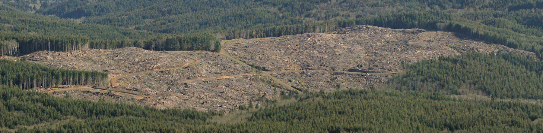
Pictures Tell the Story: OSU’s latest draft plan for the Elliott State Research Forest (ESRF) is an unwieldy mix of contradictions, obfuscation, and technical jargon put together by folks who clearly are not adept at communicating with a broader audience. When it comes to understanding this fundamental issue of compromise in the Elliott, pictures are the key.
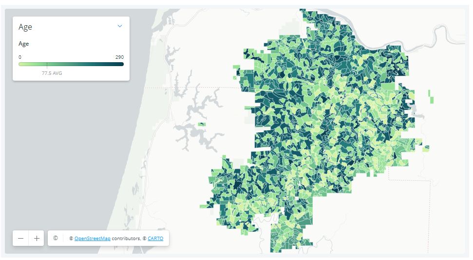
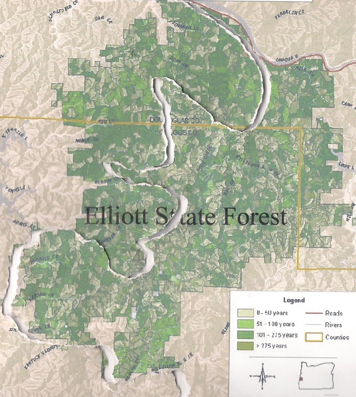
The map below shows the locations of older trees (indicated by darker shades of green) in the Elliott State Forest. It is important to note that significant quantities of older trees are scattered across vast stretches of the Forest.
Tree age classes in the Elliott State Forest (darker = older)
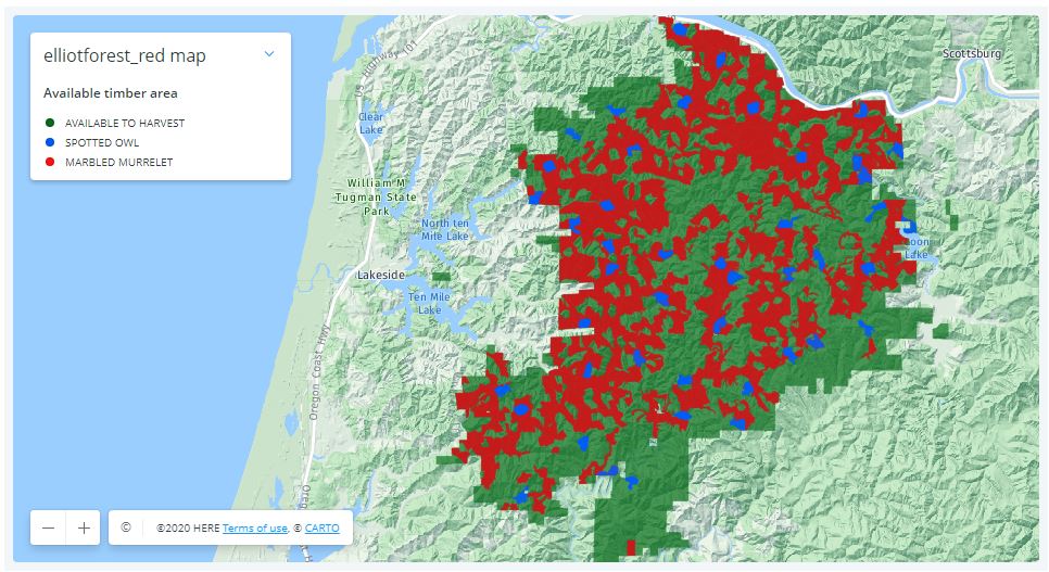
This next map shows the habitat of threatened birds (marbled murrelet in red and northern spotted owls in blue) in the Elliott. Predictably, the habitat is closely aligned with the older stands.
Habitat for threatened birds in the Elliott State Forest
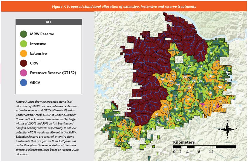
This final map shows how the OSU would divide the forest. The purple areas (denoted as “CRW”) would be “conservation research watersheds”, with limited logging allowed. The dark green areas (labeled as “MRW Reserve”) will be subject to experimental treatments (= logging) in the coming decades. The orange areas (labeled “Extensive”) will undergo thinning in which 20-80% of the trees are to be cut (including thousands of acres of older trees). The light green areas (labeled “Intensive”) are composed of trees less than 65 years of age, and will be subject to clearcutting.
OSU’s research design for the Elliott would perpetuate clearcutting or fragmentation in well over half the forest (conservation reserves shown in purple)
Viewed from the perspective of older trees and habit for our threatened birds, OSU’s plan for the Elliott is a complete disconnect. As the maps clearly show, it would sacrifice a majority of the Forest to continued clearcutting and fragmentation.
George Wuerthner’s eloquent words could not be more applicable to the Elliott:
“In far too many cases, there is a tendency to believe that it is necessary to appease local interests typically by agreeing to weakened protections or resource giveaways to garner the required political support for a successful conservation effort. However, this fails to consider that in nearly all cases where effective protective measures are enacted, it has been done over almost uniform local opposition.
In those instances where local opposition to a conservation measure is mild or does not exist, it probably means the proposal will be ineffective or worse—even set real conservation backward…Nevertheless, many environmentalists now believe that due to regional parochialism and lack of historical context, significant compromises are necessary to win approval for new conservation initiatives.“
The Elliott State Forest has already been heavily compromised – OSU’s plan would perpetuate the mistakes of the past.
The essence of OSU’s plan for the Elliott – the area on the west side would be protected, the area to the east would face continued fragmentation via a complicated matrix of “forest management” (including ~14,000 acres of clearcutting).
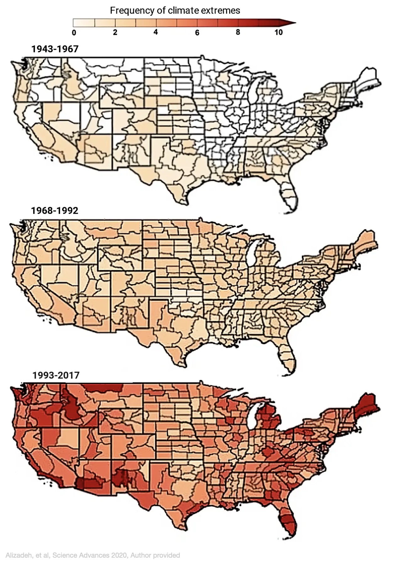
by Mojtaba Sadegh (Assistant Professor of Civil Engineering, Boise State University), Ata Akbari Asanjan (Research Scientist, Ames Research Center, NASA), and Mohammad Reza Alizadeh (Ph.D. Student, McGill University) / The Conversation
Two wildfires erupted on the outskirts of cities near Los Angeles, forcing more than 100,000 people to evacuate their homes Monday as powerful Santa Ana winds swept the flames through dry grasses and brush. With strong winds and extremely low humidity, large parts of California were under red flag warnings.
High fire risk days have been common this year as the 2020 wildfire season shatters records across the West.
What caused the 2020 fire season to become so extreme?
Fires thrive on three elements: heat, dryness and wind. The 2020 season was dry, but the Western U.S. has seen worse droughts in the recent decade. It had several record-breaking heat waves, but the fires did not necessarily follow the locations with the highest temperatures.
What 2020 did have was heat and dryness hitting simultaneously. When even a moderate drought and heat wave hit a region at the same time, along with wind to fan the flames, it becomes a powerful force that can fuel megafires.
That’s what we’ve been seeing in California, Colorado and Oregon this year. Research shows it’s happening more often with higher intensity, and affecting ever-increasing areas.
Climate change intensified dry-hot extremes
We are scientistsandengineers who study climate extremes, including wildfires. Our research shows that the probability of a drought and heat wave occurring at the same time in the U.S. has increased significantly over the past century.
The kind of dry and hot conditions that would have been expected to occur only once every 25 years on average have occurred five to 10 times in several regions of the U.S. over the past quarter-century. Even more alarming, we found that extreme dry-hot conditions that would have been expected only once every 75 years have occurred three to six times in many areas over the same period.
We also found that what triggers these simultaneous extremes appears to be changing.
During the Dust Bowl of the 1930s, the lack of rainfall allowed the air to become hotter, and that process fueled simultaneous dry and hot conditions. Today, excess heat is a larger driver of dry-hot conditions than lack of rain.
This has important implications for the future of dry-hot extremes.
Warmer air can hold more moisture, so as global temperatures rise, evaporation can suck more water from plants and soil, leading to drier conditions. Higher temperatures and drier conditions mean vegetation is more combustible. A study in 2016 calculated that the excess heat from human-caused climate change was responsible for nearly doubling the amount of Western U.S. forest that burned between 1979 and 2015.
Worryingly, we have also found that these dry-hot wildfire-fueling conditions can feed on one another and spread downwind.
When soil moisture is low, more solar radiation will turn into sensible heat – heat you can feel. That heat evaporates more water and further dries the environment. This cycle continues until a large-scale weather pattern breaks it. The heat can also trigger the same feedback loop in a neighboring region, extending the dry-hot conditions and raising the probability of dry-hot extremes across broad stretches of the country.
All of this translates into higher wildfire risk for the Western U.S.
In Southern California, for example, we found that the number of dry-hot-windy days has increased at a greater rate than dry, hot or windy days individually over the past four decades, tripling the number of megafire danger days in the region.
2020 wasn’t normal, but what is normal?
If 2020 has proved anything, it is to expect the unexpected.
Before this year, Colorado had not recorded a fire of over 10,000 acres starting in October. This year, the East Troublesome fire grew from about 20,000 acres to over 100,000 acres in less than 24 hours on Oct. 21, and it was nearly 200,000 acres by the time a snowstorm stopped its advance. Instead of going skiing, hundreds of Coloradans evacuated their homes and nervously watched whether that fire would merge with another giant blaze.
This is not “the new normal” – it’s the new abnormal. In a warming climate, looking at what happened in the past no longer offers a sense of what to expect in the future.
There are other drivers of the rise in fire damage. More people moving into wildland areas means there are more cars and power lines and other potential ignition sources. Historical efforts to control fires have also meant more undergrowth in areas that would have naturally burned periodically in smaller fires.
The question now is how to manage this “new abnormal” in the face of a warming climate.
In the U.S., one in three houses are built in the wildland-urban interface. Development plans, construction techniques and building codes can do more to account for wildfire risks, including avoiding flammable materials and potential sources of sparks. Importantly, citizens and policymakers need to tackle the problem at its root: That includes cutting the greenhouse gas emissions that are warming the planet.
On October 12th, 2020, Indigenous People’s Day, a group of indigenous people and allies gathered in Illahee (Portland, Oregon) to confront the Sierra Club and 350.org for their corporate ties and advocacy of false solutions as outlined in the film Planet of the Humans.
These groups were informed that they had breached trust with the grassroots environmental movement and local indigenous people, and had betrayed their own stated goals.
Sierra Club was informed that their promotion of “green investments” in massive multinational corporations via their “sustainable investing funds” represent a fundamental opposition to life on the planet.
350.org was informed that even their name and stated goal, 350 parts per million of carbon dioxide, is incompatible with life for the small island nations. As the Association of Small Island States write in their 2009 briefing as part of the Copenhagen climate conference, “350 ppm is a death sentence. . . . The safe level of CO2 for SIDS (Small Island Developing States) is around 260 parts per million. . . . CO2 buildup must be reversed, not allowed to increase or even be stabilized at 350 ppm, which would amount to a death sentence for coral reefs, small island developing states, and billions of people living along low lying coastlines.”
Both of these groups have and continue to advocate for false solutions, including “green” technology, “green” investments, and other greenwashing schemes. Both groups failed to sign the Universal Declaration on the Rights of Mother Earth created at the 2010 Cochabamba World People’s Conference on Climate Change, despite the opportunity to do so.
On October 12th, 2020, both groups were informed that they are no longer welcome, and were asked to cease operations in Oregon and across Turtle Island in favor of true grassroots resistance.
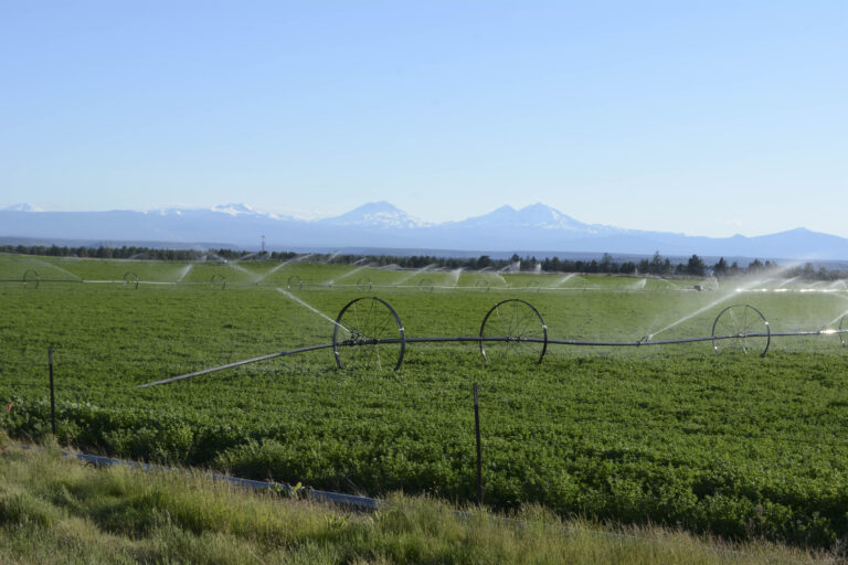
All around the world, irrigation for agriculture is taking massive amounts of water from rivers, in many cases leaving them almost or entirely dry. This article comes from central Oregon, where 90% of human water use is for agriculture.
Low Flows Due to Irrigation Destroying Deschutes River
The recent article “Low Flows On Deschutes” highlights why irrigation is a significant threat to our river’s ecological integrity.
According to the report, flows on a portion of the Deschutes dropped to 60 CFS leaving many parts of the river channel dry. To put this into perspective, historically, before irrigators took our water from us, the river ran at 1000-1200 CFS year-round. As a spring-fed river, the Deschutes supported outstanding fisheries.
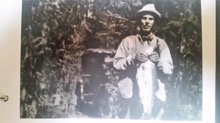
Huge trout caught out of the Deschutes near the turn of the century before irrigation destroyed the river.
This tragedy continues because the public is not standing up for its rights. We, the people, own the water in the river, not the irrigators. We allow the irrigators to take water from the river without any compensation to the public, and regardless of the damage done to aquatic ecosystems. This system was devised by irrigators to serve irrigators a century ago.
Isn’t it time for us to enter the modern age? Using water in the desert to grow hay for livestock is just a crazy waste of a valuable resource. Keeping water in the river would provide for greater recreational use. And maintaining viable flows would protect aquatic life like spotted frogs, trout, and salmon, not to mention all the other water-dependent species like eagles, mink, otter, and the rest.
Despite the claims to “water rights” the actual water in all state rivers belongs to Oregon citizens as affirmed by the Oregon Supreme Court.
“All water within the state from all sources of water supply belongs to the public,” including ground water. The Act allows for instream water rights for public uses, and public uses include but are not limited to recreation, “conservation, maintenance and enhancement of aquatic and fish life, wildlife, fish and wildlife habitat and any other ecological values,” pollution abatement, and navigation. In addition, “public uses are beneficial uses,” but “[t]he recognition of an in-stream water right . .. shall not diminish the public’s rights.”
The majority of water removed from the Deschutes is used to grow irrigated pasture and hay for livestock not crops consumed directly by humans. Photo by George Wuerthner
Technically speaking, degrading the river by irrigation should be illegal since the public values are supposed to be given priority in any water allotments.
Maybe it made sense to dewater our rivers to promote Ag a century ago when there were fewer economic opportunities. However, today Ag contributes only to 1.3% of Deschutes County income.
One can make a case that the 1% are degrading our river that belongs to all citizens for their private profit.
It is time to modernize our approach to water use. Growing cow food in the desert is a senseless waste of a valuable resource—water. We need to put the welfare of the river ecosystem and all citizens first.
George Wuerthner is an ecologist and former hunting guide with a degree in wildlife biology.
![[Green Flame] Extreme Weather Around the Planet](https://dgrnewsservice.org/wp-content/uploads/sites/18/2020/09/green-flame-NS.jpg)